Pages

Monday, 30 September 2013

Magnitude 2.5 Earthquake in northwest San Benito County, California.

The United States Geological Survey recorded a Magnitude 2.5 Earthquake at a depth of 5.5 km, 3 km southwest of San Juan Bautista in San Benito County, California, slightly before 2.05 pm local time (slightly before 9.05 pm GMT) on Saturday 28 September 2013. This is a small quake, highly unlikely to have caused any damage or casualties, though people did report feeling it in Santa Clara County to the north of the epicenter.

The approximate location of the 28 September 2013 San Juan Bautista Earthquake. Google Maps.

California is extremely prone to Earthquakes due to the presence of the San Andreas Fault, a tectonic plate margin that effectively bisects the state. The west of California, including Santa Barbara and Los Angeles, is located on the Pacific Plate, and is moving to the northwest. The east of California, including Fresno and Bakersfield is on the North American Plate, and is moving to the southeast. The plates do not move smoothly past one-another, but constantly stick together then break apart as the pressure builds up. This has led to a network of smaller faults that criss-cross the state, so that Earthquakes can effectively occur anywhere.

Witness accounts of Earthquakes can help geologists to understand these events and the underlying structures that cause them. If you felt this quake (or if you were in the area but did not, which is also useful information) then you can report it to the United States Geological Survey here.


Follow Sciency Thoughts on Facebook.

A new species of Turmeric from the Bù Gia Mập National Park in southern Vietnam.

Turmeric (Curcuma) plants are members of the Ginger Family (Zingiberaceae) native to India, southern China, Southeast Asia, Indonesia, Papua New Guinea and northern Australia. Several species are grown for use as a spice or dye, and the more colourful species are popular garden plants in tropical areas, though they need constant warm temperatures and high rainfall to thrive. The plants can reproduce both sexually by flowering and asexually by means of rhizomes (modified underground stems). These rhizomes, when cooked and dried, are also the source of spices and dyes derived from the plants.

In a paper published in the journal Phytotaxa on 26 August 2013, Jana Leong-Škorničková of The Herbarium at Singapore Botanic Gardens and Lưu Hồng Trường of the Southern Institute of Ecology at the Vietnam Academy of Science and Technology, describe a new species of Turmeric found growing in the Bù Gia Mập National Park in southern Vietnam.

The new species is named Curcuma leonidii, Leonid Averyanov of the Komarov Botanical Institute of the Russian Academy of Science, an expert on Vietnamese Orchids who discovered the first specimens of the species. Curcuma leonidii is a 30 cm herbaceous plant producing unbranching, bulb-like rhizomes and root tubers. It produces white flowers with yellow and red central parts in clusters of up to seven, low down on the plant between the leaves.

Curcuma leonidii. Leong-Škorničková & Lưu (2013).

The species is found in the understory of lowland tropical forests, usually near streams, at altitudes of between 350  and 400 m. It flowers in April-May and fruits in June. The species is known from several sites within the Bù Gia Mập National Park (which covers around 260 km²), but is unknown from outside the park, for which reason Leong-Škorničková & Lưu recommend that it be considered to be Endangered under the terms of the International Union for Conservation of Nature Red List of Threatened Species.

The approximate location of the Bù Gia Mập National Park. Google Maps.


Follow Sciency Thoughts on Facebook.

Magnitude 2.8 Earthquake in Baja California.

The United States Geological Survey recorded a Magnitude 2.8 Earthquake at a depth of 13.4 km in northern Baja California State, Mexico, roughly 24 km to the west of Mexicali and 9 km south of the border with the United States, slightly after 2.05 am local time (slightly after 9.05 am GMT) on Saturday 28 September 2013. This is not a large quake, and is unlikely to have caused any damage or casualties, but was probably felt locally.

The approximate location of the 28 September 2013 Baja California Earthquake. Google Maps.

The boundary between the Pacific and North American Plates runs beneath the Gulf of California, with Beja California lying on the Pacific Plate and the Mexican mainland on the North American. The Pacific Plate is moving northwest with regard to the North American Plate, while the North American Plate is moving southeast relative to the Pacific Plate. This creates a transform plate margin along the center of the Gulf of California, as the two plates slide past one-another, a margin that continues northward under California as the San Andreas Fault. The plates do not move past one-another smoothly, but continuously stick together then break apart as the pressure builds up, leading to regular Earthquakes beneath the Gulf of California and in the surrounding area.


Follow Sciency Thoughts on Facebook.

Magnitude 3.1 Earthquake in Sweetwater County, southwest Wyoming.

The United States Geological Survey recorded a Magnitude 3.1 Earthquake at a depth of 3.2 km in western Sweetwater County in southwest Wyoming, slightly before 2.55 am local time (slightly before 8.55 am GMT) on Saturday 28 September 2013. There are no reports of any damage or injuries arising from this event, though it is likely to have been felt locally.

The approximate location of the 28 September 2013 Sweetwater County Earthquake. Google Maps.

Wyoming typically suffers two or three moderate sized Earthquakes per year, though quakes large enough to cause significant damage are rare. The mountainous areas of the east of the state have a number of deeply buried faults where occasional movement occurs. This can be caused by movement around the Yellowstone Magma Chamber in the northeast of the state, an area that suffers more-or-less constant small tremors due to the movement of magma beneath the surface, but which seldom experiences larger quakes. The constant small movements around Yellowstone can lead to stress building up in rocks further away, leading to Earthquakes as the rocks release the strain by readjusting their positions, which can affect Wyoming as well as neighbouring Idaho and Montana. The same faults also suffer stress due to more distant rock movements, notably on the subduction zone on the American west coast.

Witness accounts of Earthquakes can help geologists to understand these events and the underlying structures that cause them. If you felt this quake (or if you were in the area but did not, which is also useful information) then you can report it to the United States Geological Survey here.


Follow Sciency Thoughts on Facebook.

Around 75 missing as Typhoon Wutip sinks Chinese fishing vessels.

Two Chinese fishing vessels are known to have sunk and a third is missing after they encountered high winds associated with Typhoon Wutip close to the Paracel islands, around 330 km south of the Chinese island of Hainan, on Sunday 29 September 2013. The ships were part of a fleet of five vessels with a combined crew of about 150 people. A rescue attempt is underway, but only 14 survivors have been found so far. Typhoon Wutip was a Category 2 storm, with sustained winds of over 96 km per hour, though it has lost some energy as it moves towards landfall in Vietnam.

The approximate location of the area where the Chinese vessels were lost. Google Maps.

Tropical storms are caused by solar energy heating the air above the oceans, which causes the air to rise leading to an inrush of air. If this happens over a large enough area the inrushing air will start to circulate, as the rotation of the Earth causes the winds closer to the equator to move eastwards compared to those further away (the Coriolis Effect). This leads to tropical storms rotating clockwise in the southern hemisphere and anticlockwise in the northern hemisphere.These storms tend to grow in strength as they move across the ocean and lose it as they pass over land (this is not completely true: many tropical storms peter out without reaching land due to wider atmospheric patterns), since the land tends to absorb solar energy while the sea reflects it.

The low pressure above tropical storms causes water to rise there by ~1 cm for every millibar drop in pressure, leading to a storm surge that can overwhelm low-lying coastal areas, while at the same time the heat leads to high levels of evaporation from the sea - and subsequently high levels of rainfall. This can cause additional flooding on land, as well as landslides, which are are a common problem after severe weather events, as excess pore water pressure can overcome cohesion in soil and sediments, allowing them to flow like liquids. Approximately 90% of all landslides are caused by heavy rainfall.


Follow Sciency Thoughts on Facebook.

Opportunistic Bivalves during the Early Jurassic Toarcian Oceanic Anoxic Event.

The Toarcian Oceanic Anoxic Event is an extinction event that took place in the Early Jurassic, about 183 million years ago. It took place in four phases, thought to have been related to Milankovitch Cycles. During each phase the temperature of the global ocean is thought to have risen abruptly by as much as 13℃, leading to a depletion in oxygen levels in the oceans, followed by an extinction event. Warmer waters are less able to retain oxygen, and this is thought to have been made worse by an increase in runoff from the continents due to higher rainfall, and a breakdown in ocean currents caused by the warming of deep oceanic waters. Each of these phases is marked by a distinct shift in Carbon, Oxygen and Strontium isotope ratios, an extinction event in the fossil record and the deposition of vast amounts of organic matter which has led to extensive hydrocarbons deposits at these levels in many places around the world. The Early Jurassic was considerably warmer than today, and it is thought that the warmest points on the Milankovitch Cycles (which are driven by cyclic variations in the Earth's orbit) raised global temperatures above a tipping point which led to runaway warming.

In a paper published in the journal Geology on 6 September 2013, Bryony Caswell of the School of Environmental Sciences at the University of Liverpool and Angela Coe of the Department of Environment, Earth and Ecosystems at the Centre for Earth, Planetary, Space and Astronomical Research at the The Open University, examine the behavior of populations of two species of opportunistic Bivalve, Bositra radiata and Pseudomytiloides dubius during the Toarcian Oceanic Anoxic Event in deposits at Whitby near North Yorkshire, England.

During the run up to the initial event the deposits were dominated by the Bivalve Bositra radiata, a Posidoniid Clam related to modern Scallops, quickly came to dominate to fauna, forming monospecific pavements and growing to sizes not achieved prior to the onset of the event. 

Bositra radiata shell pavement from Hawsker Bottoms, North Yorkshire. Scale bar is in milimeters. Caswell et al. (2009).

During the remaining three events the Inoceramid Clam Pseudomytiloides dubius (also related to modern Scallops) quickly came to dominate the faunas, again reaching larger sizes during the event. The two species appear to compete during the onset of the third event, but Pseudomytiloides dubius quickly came to dominate, suggesting that the two species competed for some resource (probably food) and that Pseudomytiloides dubius was able to outcompete Bositra radiata.

Pseudomytiloides dubius from Port Mulgrave in North Yorkshire. Scale bar is in milimeters. Caswell et al. (2009).

Bositra radiata and Pseudomytiloides dubius are both thought to have been opportunistic species. Both were small (even when reaching exceptional sizes), and are thought to have had short generation times and high larval production rates, probably comparable to the modern Mulinia lateralis, a small Surf Clam which can breed at two months old and seldom lives more than two years, which does well in anoxic conditions. Such organisms can thrive in environments even where they are exterminated each year, since they will have time to reproduce and can recolonize from adjacent areas.

The approximate location of the study area. Google Maps.

The Toarcian Oceanic Anoxic Event is of particular interest today as we are living in time when rising global temperatures, combined with local anoxic zones in parts of the oceans caused by excess runoff due to human activities, for example in the Black Sea and the Gulf of Mexico. This makes it important to understand how organisms cope (or don't) with such events, and what the long-term impact on the global biosphere is likely to be, particularly if these events become larger and more frequent.


Follow Sciency Thoughts on Facebook.

Sunday, 29 September 2013

Magnitude 4.4 Earthquake in northwest Iran.

The United States Geological Survey recorded a Magnitude 4.4. Earthquake at a depth of 36.9 km, roughly 6 km to the east of Oshnavieh in West Azerbaijan Province in the far northwest of Iran, slightly after 1.30 pm local time (slightly after 10.0 am GMT) on Friday 27 September 2013. A quake of this size at this depth is unlikely to have caused any damage or casualties, but is likely to have been felt over a wide area. 

The approximate location of the 27 September 2013 Oshnavieh Earthquake. Google Maps.


Iran is situated on the southern margin of the Eurasian Plate. Immediately to the south lies the Arabian Plate, which is being pushed northward by the impact of Africa from the south. This has created a zone of faulting and fold mountains along the southwest coast of the country, known as the Zagros Thrust Belt, while to the northeast of this the geology is dominated by three large tectonic blocks, the Central Iran, Lut and Helmand, which move separately in response to pressure from the south, stretching and compressing the rock layers close to the surface and creating frequent Earthquakes, some of which can be very large.

The population of Iran is particularly at risk from Earthquakes as, unlike other Earthquake-prone nations, very few buildings in the country are quake-resistant. The majority of residential buildings in Iran are made of mud-brick, a building material particularly vulnerable to Earthquakes as the bricks often liquify, trapping people inside and quickly asphyxiating them with dust. This is particularly dangerous at night when the majority of people are inside sleeping.


Follow Sciency Thoughts on Facebook.

Kepler 63b; a giant planet in a polar orbit.

KIC 11554435 (or Kepler Input Catalogue 11554435) is a young, sunlike star 652 light years from the Earth. It is thought to be between 200 and 300 million years old with a mass 98% of the Sun's and an effective surface temperature of ~5576 K, as opposed to 5778 K for the Sun. As a young star it rotates considerably faster than the Sun, roughly once every 5.4 days, while the Sun takes slightly under 24.5 days to complete a rotation, and has a high level of starspot activity (the same as sunspot activity but on a different star).

In a paper published on the online arXiv database at Cornell University Library on 26 August 2013, and accepted for publication in The Astrophysical Journal, a team of scientists led by Roberto Sanchis-Ojeda of the Department of Physics and Kavli Institute for Astrophysics and Space Research at the Massachusetts Institute of Technology, describe the discovery of a superjovian planet in orbit about KIC 11554435 by the Kepler Space Telescope. The system is renamed Kepler 63, with the star becoming Kepler 63A and the planet Kepler 63b (naming conventions dictate that stars are given upper case letters and planets lower case letters).

Kepler 63b orbits Kepler 63A every 9.43 days at an estimated distance from the star of 0.08 AU (8% of the distance at which the Earth orbits the Sun), making it a 'Hot Jupiter' type planet, transiting the star (passing in front of it from out point of view) as it does so. It has a highly oblique orbit, at 104° to the plane of the star's rotation. Kepler 63b has a radius 6.1 times that of Jupiter, and while it was not possible to determine its mass, this was given an upper limit of 120 times that of Jupiter.

Sanchis-Ojeda et al. were also able to detect a particularly large and apparently permanent starspot (or cluster of starspots) close the the pole of rotation of Kepler 63A that is turned towards us. This moves around the pole with the star's rotation, so that it is sometimes in line with the orbit of the planet and sometimes not.

Locations of the spot, transit chord, and planet at midtransit, according to the best-fitting model. Sanchis-Ojeda et al. (2013).


Follow Sciency Thoughts on Facebook.

Magnitude 4.2 Earthquake in Semnan Province, northern Iran.

The United States Geological Survey recorded a Magnitude 4.2 Earthquake at a depth of 12.9 km in western Semnan Province, northern Iran, slightly before 9.35 am local time (slightly before 6.05 am GMT) on Friday 27 September 2013. There are no reports of any damage or casualties arising from this quake, although it is likely to have been felt locally.

The approximate location of the 27 September 2013. Google Maps.

Iran is situated on the southern margin of the Eurasian Plate. Immediately to the south lies the Arabian Plate, which is being pushed northward by the impact of Africa from the south. This has created a zone of faulting and fold mountains along the southwest coast of the country, known as the Zagros Thrust Belt, while to the northeast of this the geology is dominated by three large tectonic blocks, the Central Iran, Lut and Helmand, which move separately in response to pressure from the south, stretching and compressing the rock layers close to the surface and creating frequent Earthquakes, some of which can be very large.

The population of Iran is particularly at risk from Earthquakes as, unlike other Earthquake-prone nations, very few buildings in the country are quake-resistant. The majority of residential buildings in Iran are made of mud-brick, a building material particularly vulnerable to Earthquakes as the bricks often liquify, trapping people inside and quickly asphyxiating them with dust. This is particularly dangerous at night when the majority of people are inside sleeping.


Follow Sciency Thoughts on Facebook.

A new species of Jumping Spider from Papua, Indonesia.

Jumping Spiders (Salticidae) are specialists who actively hunt their prey, rather than trapping it in webs as most Spiders do. They have extremely well developed vision, with large, forward facing eyes, and an enhanced respiratory system, which enables them to keep their tissues well oxygenated. Jumping Spiders actively move about looking for prey; most of the time they move quite slowly, but once suitable prey is detected they can leap onto it from some distance, and hold it with enlarged front legs. They are an extremely successful group, with over 5000 described species (approximately 13% of all described Spider species. They have a fossil record dating back to the Eocene, with specimens known from Baltic amber, roughly 44 million years old.

In a paper published in the journal Zootaxa on 23 May 2013, Joanna Gardzińska and Barbara Patoleta of the Department of Zoology at Siedlce University of Natural Sciences and Humanities describe a new species of Jumping Spider from Sarmi District in Papua, Indonesia. The description is based upon specimens collected in 1959, and held in the Royal Belgian Institut of Natural Sciences.

The new species is placed in the genus Diolenius, which previously included 14 species, all from New Guinea, New Britain, the Moluccas and adjacent islands, and which is classified within a wider group of Jumping Spiders all restricted to Australasia. It is given the specific name Diolenius sarmiensis, referring to the area where it was found.

Diolenius sarmiensis, female in dorsal view. Scale bare is 1 mm. Gardzińska & Patoleta (2013).

Diolenius sarmiensis is a 4-5 mm dark brown Jumping Spider. It's legs are orange or pale brown, though the enlarged forelegs have dark brown patches. The female is lighter in colour than the male, and has a marked constriction of the abdomen which the male lacks.

The approximate location of the area where Diolenius sarmiensis was discovered. Google Maps.


Follow Sciency Thoughts on Facebook.

Magnitude 3.6 Earthquake on Big Island, Hawai'i.

The United States Geological Survey recorded a Magnitude 3.6 Earthquake at a depth of 7.7 km, 41 km to the south of Hilo, slightly after 8.35 am local time (slightly after 6.35 pm GMT) on Thursday 26 September 2013. This is not a large quake, and is unlikely to have caused any damage or injuries, but was felt across much of the east of the island.

The approximate location of the 26 September 2013 Big Island Earthquake. Google Maps.

Big Island, Hawai'i, sits on top of a volcanic hotspot, an area where magma from deep inside the Earth is welling up through the overlying plate (in this case the Pacific) to create volcanism at the surface. The island comprises five overlapping shield volcanoes, two of which are currently active and another two of which are considered to be dormant with the possibility of reactivating in the future. Volcanoes move as they erupt, swelling as magma enters their chambers from bellow, then shrinking as that magma is vented as lava. The movements of a group of volcanoes close to one another can place considerable strain on layered rocks, and the islands of Hawai'i, and in particular Big Island, are very prone to Earthquakes, though these tend to be small and frequent rather than large, rare and destructive.

Witness accounts of quakes can help geologists to understand these events and the rock structures that cause them. If you felt this quake (or if you were in the area but did not, which is also useful information) you can report it to the USGS here.


Follow Sciency Thoughts on Facebook.

Asteroid 2013 SK20 passes the Earth.

Asteroid 2013 SK20 passed the Earth at a distance of 872 000 km (roughly 2.3 times the distance between the Earth and the Moon) on Sunday 29 September 2013. The 15 m diameter object is thought to have an elliptical 493 day orbit which takes it outside that of Mars and in almost as far as the orbit of Venus. This means that it passes the Earth on a fairly regular basis, with the most recent close encounters having come in September 2009 and September 2005, and future close visits predicted in January 2022 and March 2026. It is not thought to present any serious threat to the Earth however, as an object this size would be predicted to burn up in the atmosphere at an altitude of about 26 km, with only fragmentary material reaching the ground.

The orbit of 2013 SK20. JPL Small Body Database Browser.

2013 SK20 was only discovered this month; the name 2013 SK20 means the 510th object discovered in the second half of September 2013 (period 2013 S). It has an average distance from the Sun (semi-major axis) greater than that of the Earth, but passes inside of the Earth's orbit, making it a member of the Apollo Group of asteroids.


Follow Sciency Thoughts on Facebook.

Friday, 27 September 2013

Magnitude 2.5 Earthquake on the San Diego/Riverside County boundary, southern California.

The United States Geological Survey recorded a Magnitude 2.5 Earthquake at a depth of 8.5 km on the boundary between San Diego and Riverside Counties slightly before 9.40 am local time (slightly before  4.40 pm GMT) on Thursday 26 September 2013. This is not a large quake, and is unlikely to have caused any damage or injuries, but is likely to have been felt locally.

The approximate location of the 26 September 2013 San Diego/Riverside County boundary Earthquake. Google Maps.


California is extremely prone to Earthquakes due to the presence of the San Andreas Fault, a tectonic plate margin that effectively bisects the state. The west of California, including Santa Barbara and Los Angeles, is located on the Pacific Plate, and is moving to the northwest. The east of California, including Fresno and Bakersfield is on the North American Plate, and is moving to the southeast. The plates do not move smoothly past one-another, but constantly stick together then break apart as the pressure builds up. This has led to a network of smaller faults that criss-cross the state, so that Earthquakes can effectively occur anywhere.

Witness accounts of Earthquakes can help geologists to understand these events and the underlying structures that cause them. If you felt this quake (or if you were in the area but did not, which is also useful information) then you can report it to the United States Geological Survey here.


Follow Sciency Thoughts on Facebook.

Magnitude 2.8 Earthquake in San Benito County, California.

The United Stated Geological Survey recorded a Magnitude 2.8 Earthquake at a depth of 8.2 km, 11 km to the southeast of Hollister in San Benito County, California, slightly after 0.55 am local time (slightly after 7.55 am GMT) on Thursday 26 September 2013. This is not a large quake, and is unlikely to have caused any damage or casualties, but is likely to have been felt locally.

The approximate location of the 26 September 2013 San Benito County Earthquake. Google Maps.

California is extremely prone to Earthquakes due to the presence of the San Andreas Fault, a tectonic plate margin that effectively bisects the state. The west of California, including Santa Barbara and Los Angeles, is located on the Pacific Plate, and is moving to the northwest. The east of California, including Fresno and Bakersfield is on the North American Plate, and is moving to the southeast. The plates do not move smoothly past one-another, but constantly stick together then break apart as the pressure builds up. This has led to a network of smaller faults that criss-cross the state, so that Earthquakes can effectively occur anywhere.

Witness accounts of Earthquakes can help geologists to understand these events and the underlying structures that cause them. If you felt this quake (or if you were in the area but did not, which is also useful information) then you can report it to the United States Geological Survey here.


Follow Sciency Thoughts on Facebook.

Four new species of fossil Diatom from the western United States.

Diatoms are single celled algae related to Kelp and Water Moulds. They are encased in silica shells with two valves. During reproduction the cells divide in two, each of which retains one valve of the shell, growing a new opposing valve, which is slightly smaller and fits flush within the older valve. This means that the Diatoms grow smaller with each new generation, until they reach a minimum size, when they undergo a phase of sexual reproduction, giving rise to a new generation of full-sized cells.

In a paper published in the journal Phytotaxa on 29 August 2013, Patrick Kociolek of the University of Colorado Museum of Natural History and the Department of Ecology and Evolutionary Biology at the University of Colorado and Galina Khursevich of the Department of Botany at the Maxim Tank Belarus State Pedagogical University, describe four new species of fossil freshwater Diatoms from Oregon and Idaho, all of which are placed in the genus Cyclotella.

The first new species described is Cyclotella idahica, which is described from specimens from Christmas Valley in Oregon and Payette County, Idaho. It is thought to be 11 to 12 million years old. Cyclotella idahica is an 8.0–48.0 μm oval or elliptical Diatom. It has an oval central zone, with an irregular arrangement of areolae (holes through which the organism obtained nutrients), surrounded by an outer rim in which pores are arranged in distinct bands.

Cyclotella idahica, Valve view showing transversely undulate central area with irregularly arranged areolae and covered by bumps. Present are external openings of areolae and short tubes of marginal fultoportulae. Spines and/or spines bases are found on the valve face/mantle junction. Scale bars is 1 μm. Kociolek & Khursevich (2013).

The second new species described is Cyclotella discostelliformica, which is described from material from two sites in Klamath County, Oregon. This is an almost circular diatom 5.0–17.0 μm in diameter. The center of the valve is concave with 5-17 areolae arranged apparently at random, this is surrounded by a number of bands of smaller pores arranged radially.

Cyclotella discostelliformica, External view showing valves with sunken central areas. Fascicles are composed of 2–5 rows of areolae. Openings of the marginal fultoportulae are located at or near the thickened ribs. They lack tubes or thickenings. The central portion of the valves have isolated areolae, that are larger than those of the fascicles. Scale bar is 1 μm. Kociolek & Khursevich (2013).

Third new species described is named Cyclotella stoermeri, which is named from a single site in Klamath County, Oregon. Cyclotella stoermeri is a 7–100 μm circular Diatom. It has a central area with areolae arranged in radial rows, surrounded by a ring of radial striations that brach dichotomously towards the rim.

Cyclotella stoermeri, external valve view. Fascicles are comprised of 1–3 rows of small areolae. The ribs are thickened and elevated, becoming thinner on the valve mantle. The valve center has enlarged areolae. Kociolek & Khursevich (2013).

The final new species described is named Cyclotella pseudokansasica, which is named from a single specimen from Owyhee County, Idaho. Cyclotella pseudokansasica is a 10–23 μm diameter circular Diatom with a central area with irregularly arranged areolae and a wider outer area with radiate bands of pores separated by distinct ribs.

Cyclotella pseudokansasica, external valve view. Prominent spines or spine bases are located about the periphery of the valves. Multiseriate fascicles alternate with thick costae. Openings of the marginal fultoportulae are located near the base of the mantle. Scale bar is 1 μm. Kociolek & Khursevich (2013).


Follow Sciency Thoughts on Facebook.

A Marrellomorph Arthropod from the Late Ordovician of the Czech Republic.

The enigmatic fossil Furca bohemica was first recorded from Late Ordovician deposits at Veselá Gorge, in what is now the Czech Republic, by the French Palaeontologist Joachim Barrande in 1846, though he never formally described the specimens. A formal description was provided by Antonin Fritsch in 1908, who interpreted it as a larval Echinoderm. Since 1919 it has generally been recognized as being an Arthropod, but palaeontologists have disagreed as to its affinities, with different scientists regarding it to be a Trilobite, a Chelloniellid and a Marrellomorph.

In a paper published in the August 2013 edition of the journal Acta Palaeontologica Polonica Štěpán Rak of the Institute of Geology and Palaeontology at Charles UniversityJavier Ortega−Hernández of the Department of Earth Sciences at the University of Cambridge and David Legg of the Department of Earth Sciences and Engineering at Imperial College London describe the discovery of a large number of new specimens of Furca bohemica a recently discovered section of the Letná Formation on the southern slope Ostrý Hill in Beroun and in a debris of the classical site Veselá Gorge. These new finds enable a better description of the species, and enable them to more confidently place it within the Marrellomorpha.

Specimen of Furca bohemica preserved in fine sandstone. Scale bar is 10 mm. Rak et al. (2013).

Furca bohemica has a six-spined shield shape, typical of Marrellomorph Arthropods, but is surrounded by secondary structures which are harder to explain, and which if legs or cilia would rule out placing the fossils in any known Arthropod Group. Rak et al. interpret these as a fringe of secondary spines surrounding the main shield, an interpretation which does not rule out Arthropod affinities, and which allows the placement of Furca bohemica confidently within the Marrellomorph Arthropods.

New morphological reconstruction of the Marrellomorph Arthropod Furca bohemica in dorsal view. Scale bar is 10 mm. Rak et al. (2013).


Follow Sciency Thoughts on Facebook.

Magnitude 1.7 Earthquake in South Yorkshire.

The British Geological Survey recorded a Magnitude 1.7 Earthquake at a depth of 1 km, roughly 5 km to the west of the town of Thorne in South Yorkshire, slightly after 7.20 am British Summertime (slightly after 6.20 am GMT) on Thursday 26 September 2013. This is a small quake, highly unlikely to have caused any damage or casualties, but which may have been felt locally.

The approximate location of the 26 September 2013 South Yorkshire Earthquake. Google Maps.

Earthquakes become more common as you travel north and west in Great Britain, with the west coast of Scotland being the most quake-prone part of the island and the northwest of Wales being more prone  to quakes than the rest of Wales or most of England.

The precise cause of Earthquakes in the UK can be hard to determine; the country is not close to any obvious single cause of such activity such as a plate margin, but is subject to tectonic pressures from several different sources, with most quakes probably being the result of the interplay between these forces.

Britain is being pushed to the east by the expansion of the Atlantic Ocean and to the north by the impact of Africa into Europe from the south. It is also affected by lesser areas of tectonic spreading beneath the North Sea, Rhine Valley and Bay of Biscay. Finally the country is subject to glacial rebound; until about 10 000 years ago much of the north of the country was covered by a thick layer of glacial ice (this is believed to have been thickest on the west coast of Scotland), pushing the rocks of the British lithosphere down into the underlying mantle. This ice is now gone, and the rocks are springing (slowly) back into their original position, causing the occasional Earthquake in the process. 

Witness accounts of Earthquakes can help geologists to understand these events, and the structures that cause them. If you felt this quake, or were in the area but did not (which is also useful information) then you can report it to the British Geological Survey here.

A new species of Albanerpetontid Amphibian from the Early Cretaceous of the Isle of Wight.

The Albanerpetontid Amphibians were a distinct order of Lisamphibians (the group that includes all modern Amphibians and anything else descended from their most recent common ancestor) known in the fossil record from the Middle Jurassic to the late Pliocene. They were morphologically conservative, resembling Salamanders in shape (though they were distinctive). A single known specimen with preserved skin was scaly and had eyelids, implying a dryer habitat preference than Salamanders, though it is not known if this applied to the whole group.

In a paper published in the April 2013 edition of the journal Acta Palaeontologica Polonica, Steven Sweetman of the School of Earth and Environmental Sciences at the University of Portsmouth and James Gardner of the Royal Tyrrell Museum of Palaeontology describe a new species of Albanerpetontid Amphibian from the Early Cretaceous Wessex Formation of the Isle of Wight.

The new species is named Wesserpeton evansae, where 'Wesserpeton' means 'creeping animal from Wessex' and 'evansae' honours Susan Evans of University College London, a distinguished microvertebrate palaeontologist who has make important contributions to our understanding of the Albanerpetontids.

Wesserpeton evansae is described from a series of disarticulated, mostly partial, skeletons comprising frontal (forehead) bones, premaxillae (front part of the upper jaw), maxillae (remainder of the upper jaw), fragments of dentary, a number of fragmentary articular and angular bones (bones connecting the lower jaw to the skull, fused in Albanerpetontid Amphibians and moved to the inner ear in Mammals), a single prearticular, a variety of vertebrae, one complete and several partial humeri and several partial ilia.

Scanning electron micrographs of two nearly complete dentaries of the Albanerpetontid Amphibian Wesserpeton evansae from the Barremian Wessex Formation at Yaverland on the Isle of Wight. (A) substantially complete left dentary missing most of area for attachment of post−dentary bones in lingual (A₁), labial (A₂), and dorsal (A₃) views. (B) Right dentary preserving similar amount of bone, but with pathological anterior portion in lingual (B₁) and dorsal (B₂) views; enlargement of the anterior end in ventral view (B₃), showing bony callous and distortion in region of possible healed fracture and re−modelled symphyseal surface. Sweetman & Gardner (2013).


Follow Sciency Thoughts on Facebook.

Couple, baby, rescued after Philippine landslide.

A couple and their baby have been rescued after their home, described as a hut by a river, was destroyed by a landslide in the village of Inicbulan in Barangay Province, the Philippines, roughly 100 km south of Manila, at about 11.00 pm local time (about 3.00 pm GMT) on Thursday, 26 September 2013. The husband, Eric Lansito was only partially buried, and was quickly rescued, as was his 8 month old son. Rescuers form the Bureau of Fire Protection, Philippine National Police, Philippine Coast Guard and Red Cross were unable to locate Jean Lansito (18) despite searching through the night, and initial press reports stated that she was believed to have died. However it is reported that she was discovered unconscious at about midday local time on Friday 27 September, and taken to a local hospital where her condition is described as serious.

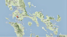
The approximate location of the 26 September 2013 Inicibulan landslide. Google Maps.

The incident happened following several days of heavy rain in the wake of the passage of Typhoon Odette. The low pressure above tropical storms causes water to rise there by ~1 cm for every millibar drop in pressure, leading to a storm surge that can overwhelm low-lying coastal areas, while at the same time the heat leads to high levels of evaporation from the sea - and subsequently high levels of rainfall. This can cause additional flooding on land, as well as landslides, which are are a common problem after severe weather events, as excess pore water pressure can overcome cohesion in soil and sediments, allowing them to flow like liquids. Approximately 90% of all landslides are caused by heavy rainfall.


Follow Sciency Thoughts on Facebook.

Magnitude 2.8 Earthquake in Oklahoma County, Oklahoma.

The United States Geological Survey recorded a Magnitude 2.8 Earthquake at a depth of 5.4 km roughly 23 km northeast of Oklahoma City, slightly after 0.15 am local time (slightly after 5.15 am GMT) on Thursday 26 September 2013. This is a small quake, unlikely to cause any damage or casualties, but was felt across a wide area of central Oklahoma County.

The approximate location of the 26 September 2013 Oklahoma County Earthquake. Google Maps.

Oklahoma is naturally prone to Earthquakes, particularly in the southwest of the state, near the Meers Fault Zone, but since 2009 has suffered a sharp increase in the number of small quakes in the central and northeast parts of the state. While most of these quakes have been quite small, a few have been large enough to potentially cause problems, and any unexplained increase in seismic activity is a cause for concern. 

In a paper published in the journal Geology on 26 March 2013, a team of geologists led by Katie Keranen of the ConocoPhillips School of Geology and Geophysics at the University of Oklahoma linked one of the largest of these quakes, a Magnitude 5.7 event in November 2011 which caused damage locally and was felt across 17 states, to the practice of pumping liquids (usually brine) into injection wells, which is common in the hydrocarbons industry and used to displace oil or gas, which can then be extracted from nearby extraction wells (where this is done in bursts at pressure to intentionally break up rock it is called hydraulic fracturing, or fracking). Significantly they suggested that the practice could lead to quakes years or even decades after the actual injection.

Witness accounts of quakes can help geologists to understand these events and the rock structures that cause them. If you felt this quake (or if you were in the area but did not, which is also useful information) you can report it to the USGS here.


Follow Sciency Thoughts on Facebook.

Thursday, 26 September 2013

Magnitude 7.0 Earthquake off the coast of Peru.

The United States Geological Survey recorded a Magnitude 7.0 Earthquake at a depth of 40 km, roughly 17 km off the coast of southern Peru, slightly after 11.40 am local time (slightly after 4.40 pm GMT) on Wednesday 25 September 2013. This is a large quake with the potential to cause severe damage, and has reportedly triggered several landslides and caused partial or complete damage to at least seventy buildings in nearby areas, with adobe structures being particularly badly affected. The quake also caused damage at a number of copper and iron mines, with at least seven miners being injured, some severely, at different sites, though it appears that early reports of fatalities were inaccurate. Another ten people are thought to have been injured in Earthquake-related accidents outside of mines. The quake was felt as far away as Lima, 500 km to the north of the epicenter, and in northern Chile, 500 km to the southeast.

The approximate location of the 25 September 2013 Peru Earthquake. Google Maps.

Peru is on the west coast of South America and the western margin of the South American Plate, close to where the Nazca Plate, which underlies part of the east Pacific, is being subducted along the Peru-Chile Trench. The Nazca Plate passes under the South American Plate as it sinks into the Earth, this is not a smooth process and the plates repeatedly stick together then break apart as the pressure builds up, causing Earthquakes. As the Nazca Plate sinks further it is partially melted by the friction and the heat of the Earth's interior. Some of this melted material then rises through the overlying South American Plate, fueling the volcanoes of Peru and neighboring countries.


Follow Sciency Thoughts on Facebook.

Eruption on Mount Telica, Nicaragua.

A small explosion to place on Mount Telica in northwest Nicaragua at about 6.50 am local time (about 12.50 pm GMT) on Wednesday 25 September 2013, producing an ash column approximately 1.5 km in height. There has been no further activity on the volcano, but local authorities are monitoring the situation closely. This is the first eruption on Telica this year, however it has undergone bouts of eruptive behavior several times over the last few years, and a number of Earhquake swarms this year have suggested that further eruptions were likely.

A small eruption on Mount Telica in November 1976. Jamie Incer/Smithsonian Global Volcanism Program.

Nicaragua is located on the southern edge of the Caribbean Plate, which underlies Central America as well as the Caribbean Sea. To the south the Cocos Plate, which underlies part of the eastern Pacific, is being subducted beneath the Caribbean Plate along the Middle American Trench, passing under Central America as it is sinks into the Earth. As it is subducted the Cocos Plate is being partially melted by the heat of the planet's interior and the friction caused by its dragging under the Caribbean Plate, producing liquid magma, which then rises through the overlying plate fueling the volcanoes of Central America.

The approximate location of Mount Telica. Google Maps.


Follow Sciency Thoughts on Facebook.