Pages

Tuesday, 31 December 2013

Over 100 people forced from homes by landslide in Dundee, Scotland.

Over 100 people have been forced from their homes by a landslide in Dundee, Scotland, at about 4.00 pm GMT on Monday 30 December 2013. A 40 m section of slope behind a block of tenement flats on Gardener Street collapsed, undermining the properties, and causing several tonnes of earth and debris to  pile against a second block of tenements in Lochee Road, 50 m downslope. Nobody was hurt, but authorities evacuated 24 flats in Gardner Street and a further 20 in Lochee Road as a precaution. The situation will now be assessed by the City Engineer.

The site of the 30 December 2013 Dundee Landslide. DC Thompson/Dougie Nicolson/The Courier.

The incident came after several days of heavy rain, which has led to high river levels in the area and the issuing of flood warnings by the Scottish Environment Protection Agency. Landslides are a common problem after severe weather events, as excess pore water pressure can overcome cohesion in soil and sediments, allowing them to flow like liquids. Approximately 90% of all landslides are caused by heavy rainfall. However some residents of the area have linked the incident to a long-standing sewer problem in the area.

The approximate location of the 30 December 2013 Dundee landslide. Google Maps.


Follow Sciency Thoughts on Facebook.

Magnitude 3.6 Earthquake in Riverside County, California.

The United States Geological Survey recorded a Magnitude 3.6 Earthquake at a depth of 19.6 km  in the San Jacinto Mountains in Riverside County, California, slightly before 3.45 pm local time (slightly before 11.45 pm GMT) on Monday 30 December 2013. There are no reports of any damage or injuries associated with this event, though people reported feeling it as far away as San Diego, slightly over 100 km to the southwest.

The approximate location of the 30 December 2013 Riverside County Earthquake. Google Maps.

California is extremely prone to Earthquakes due to the presence of the San Andreas Fault, a tectonic plate margin that effectively bisects the state. The west of California, including Santa Barbara and Los Angeles, is located on the Pacific Plate, and is moving to the northwest. The east of California, including Fresno and Bakersfield is on the North American Plate, and is moving to the southeast. The plates do not move smoothly past one-another, but constantly stick together then break apart as the pressure builds up. This has led to a network of smaller faults that criss-cross the state, so that Earthquakes can effectively occur anywhere.

Witness accounts of Earthquakes can help geologists to understand these events and the underlying structures that cause them. If you felt this quake (or if you were in the area but did not, which is also useful information) then you can report it to the United States Geological Survey here.


Follow Sciency Thoughts on Facebook.

A new species of Leptictid Mammal from the Late Eocene of South Dakota.

Leptictid Mammals appeared early in the post-Cretaceous radiation of Mammals, and persisted till the Oligocene. They may have been distant relatives of the Rodents and Primates, though some authors regard them as being the earliest group to break of from the other Placental Mammals. They were small Mammals, the largest reaching about 90 cm, and appear to have been primarily insectivorous in diet. Many Leptictids had reduced forelimbs, and are thought to have had a hopping gait similar to Kangaroos or Jerboas.

In a paper published in the journal Acta Palaeontologica Polonica on 17 August 2011, Terence Meehan of the Section of Vertebrate Paleontology at the Carnegie Museum of Natural History and Larry Martin of the Division of Vertebrate Paleontology at the Natural History Museum and Biodiversity Research Center at the University of Kansas, describe a new species of Leptictid Mammal from the Late Eocene White River Group of South Dakota.

The new species is named Megaleptictis altidens, where 'Megaleptictis' means 'Large Leptictid' and 'altidens' means 'tall-toothed'. The species is described from a nearly complete skull and mandibles, with most of the teeth intact. The skull of Megaleptictis altidens is large for a Leptictid, the snout broad, and the teeth higher and more heavily worn than in other comparable species. 

Megaleptictis altidens (A1), skull in dorsal view, note the postorbital constriction of the parasagittal crests; (A2) lateral view, the teeth and rostrum are tall; (A3) stereo pair, ventral view; (A4) occipital view. A portion of the supraoccipital region is broken away. Scale bars are 10 mm. Meehan & Martin (2011).

Megaleptictis altidens. (B1) Left dentary in lateral view; i2–m2 are well preserved, except for the  fractured crown of p3; the base of i1 and posterior talonid of m3 are present; the posterior ramus is broken away, except for a portion of the condyloid region shown in its approximate position. (B2) Occlusal view of mandibles placed in articulation. (B3). Right dentary in lateral view; complete p3–m2 and the fractured bases of i2–p2 and m3 are present. Meehan & Martin (2011).

The higher teeth and increased dental wear of Megaleptictis altidens compared to other Leptictid Mammals, and indeed other insectivorous Mammals in general, suggests tat that their diet may not have been the same as that of other members of the group. The modern Sengis (or Elephant Shrews) of Africa are often considered to be a good ecological model of for the Leptictids, and also have high teeth. However the fossil record of Sengis suggests that they have only adopted an insectivorous lifestyle quite recently, and that the higher teeth may be a relict from a previous plant-based diet. 

High teeth and heavy dental wear are typically associated with a diet high in plant matter, and the teeth of Megaleptictis altidens show adaptations apparently converging on those of Lagomorphs (Rabbits). This strongly suggests that Megaleptictis altidens may have had a large amount of plant matter in its diet. The late Eocene was a time of drying climate, and increased seasonality, and Megaleptictis altidens probably had to contend with a long dry season when Insects would have been scarce. Meehan & Martin suggest that this increased seasonality and scarcity of Insect food may have caused Megaleptictis altidens to change its diet, consuming a higher proportion of plant matter than earlier Leptictids.

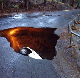
Pickup truck swallowed by sinkhole on Big Island, Hawaii.

A pickup truck and its driver were swallowed by a sinkhole on the Pohakea Mauka Road near Paauilo on the northeast coast of Big Island, Hawaii, at about 8.00 am local time (about 6.00 pm GMT) on Monday 30 December 2013. The driver of the vehicle, Velma Deluz, was able to climb out of the hole herself, but was described by relatives as 'severly shaken' by the event, and received hospital treatment for her injuries.

The vehicle inside the hole on Pohakea Mauka Road on 30 December 2013. Hawaii Civil Defence Agency.

Sinkholes are generally caused by water eroding soft limestone or unconsolidated deposits from beneath, causing a hole that works its way upwards and eventually opening spectacularly at the surface. Where there are unconsolidated deposits at the surface they can infill from the sides, apparently swallowing objects at the surface, including people, without trace. It is thought that on this occasion the sinkhole was caused by a leak from a culvert carrying rainwater beneath the road, which washed away the surrounding soil, undermining the road, following a night of severe rain.


 Follow Sciency Thoughts on Facebook.

A new species of Earwigfly from Brazil.

Earwigflies (Meropeidae) are a small group within the Mecoptera (Scorpionflies), known only from four fossil and two modern species. Three of the fossil species are from the Triassic of Kyrgyzstan, and the fourth from the Jurassic of Siberia, while the two modern species, Merope tuber and Austromerope poultoni are from North America and Australia respectively. Little is known of the biology of these Insects, the larvae having never been observed. It is thought that they may have been more diverse in the Mesozoic, and that the modern populations are a relict.

In a paper published in the journal ZooKeys on 15 February 2013, Renato Machado of the Department of Entomology at Texas A & M University, Ricardo Kawada of the Laboratório de Entomologia Sistemática at the Universidade Federal do Espírito Santo and José Rafael of the Instituto Nacional de Pesquisas da Amazonia, describe a new species of extant Earwigfly from Espírito Santo State in Brazil.

The new species is placed in the genus Austromerope, and given the specific name brasiliensis, meaning 'from Brazil'. Austromerope brasiliensis is described from a single 20 mm male specimen caught in a Malaise trap (tent like net structure used by entomologists to trap flying insects) at Domingos Martins in Espírito Santo State Brazil.

Austromerope brasiliensis, male specimen from. Domingos Martins in Espírito Santo State Brazil. Machado et al. (2013).

Austromerope brasiliensis is more similar to the Australian species Austromerope poultoni than the North American Merope tuber. As well as being the first member of the Meropeidae recorded in South America, Austromerope brasiliensis is the fourth Scorpionfly known from South America belonging to a family also known from Australia, other than the Bittacidae (Hangingflies), which are global in distribution. The other three species are all members of the genus Nannochorista, which is also known from Australia. The genus Nannochorista, along with a second genus, Microchorista, which comprises one species from New Zealand, comprise the family Nannochoristidae. All other Australian families of the Mecoptera are endemic (found only in Australia), whereas North American families of Scorpionflies tend to be found in Earasia as wel. One family, the Eomeropidae, comprises only a single species from South America. This implies that the Meropeidae had arisen before the breakup of the supercontint of Pangea in the Jurassic, with the lineages that gave rise to the modern genera Merope and Austromerope being trapped on Laurasia and Gondwana respectivel, while.most other famlies of the Meropidae apparently arose later.

See also Leaf mimicry in a Jurassic Scorpionfly, Three new species of Scorpionfly from the early Eocene of British Columbia and Washington State and A new species of Scorpionfly from Baltic Amber.

Follow Sciency Thoughts on Facebook.

Asteroid 2013 YB14 passes the Earth before being discovered.

The asteroid 2013 YB14 passed by the Earth at a distance of 7 378 000 km (slightly under 19.2 times the distance between the Earth and the Moon) a little before 6.55 am on Tuesday 24 December 2013 (Christmas Eve). There was no danger of the asteroid hitting us, though had it done so it would have presented a realistic risk. 2013 YB14 is estimated to be between 52 and 160 m in diameter, and an object towards the upper end of this range would be expected to punch straight through the Earth's atmosphere and impact the ground, resulting in an explosion over 45 000 times as powerful as the Hiroshima bomb, which would create a crater in excess of 2.5 km in diameter and lead to devastation over a wide area, as well as climatic effects that would last for years.

The calculated orbit of 2013 YB14. JPL Small Body Database Browser.

2013 YB14 was discovered on 26 December 2013 (Boxing Day, two days after its closest pass to the Earth) by the University of Arizona's Catalina Sky Survey in the Catalina Mountains north of Tucson. The designation 2013 YB14 implies that it was the 352nd asteroid discovered in the second half of December 2013 (period 2013 Y).

2013 YB14 has a 3.91 year orbital period and an eccentric orbit that takes it from 0.73 AU from the Sun (i.e. 73% of the average distance at which the Earth orbits the Sun, inside the orbit of Venus) to 4.23 AU from the Sun (i.e. 423% of the average distance at which the Earth orbits the Sun, considerably more than twice the distance at which Mars orbits the Sun). It is therefore classed as an Apollo Group Asteroid (an asteroid that is on average further from the Sun than the Earth, but which does get closer).


Follow Sciency Thoughts on Facebook.

Magnitude 3.1 Earthquake in eastern Idaho.

The United States Geological Survey recorded a Magnitude 3.1 Earthquake at a depth of 4.4 km beneath the city of Driggs in  Teton County in eastern Idaho, slightly before 5.05 pm local time on Sunday 29 December 2013 (slightly before 0.05 am on Monday 30 December, GMT). There are no reports of any damage or injuries associated with this event, though many people reported feeling the quake.

The approximate location of the 29 December 2013 Driggs Earthquake. Google Maps.

The quake took place close to the Yellowstone Magma Chamber in the northeast of Wyoming, an area that suffers more-or-less constant small tremors due to the movement of magma beneath the surface, but which seldom experiences larger quakes. The constant small movements around Yellowstone can lead to stress building up in rocks further away, leading to Earthquakes as the rocks release the strain by readjusting their positions, which can affect Wyoming as well as neighbouring Idaho and Montana. The same faults also suffer stress due to more distant rock movements, notably on the subduction zone on the American west coast.

Witness accounts of Earthquakes can help geologists to understand these events and the underlying structures that cause them. If you felt this quake (or if you were in the area but did not, which is also useful information) then you can report it to the United States Geological Survey here.


Follow Sciency Thoughts on Facebook.

Monday, 30 December 2013

The Lunar Perigee.

The Moon will be at its closest to the Earth since 19 March 2011 slightly after 9.00 pm GMT on Wednesday 1 January 2014, when it comes to approximately 356 921 km away (in 2011 it reached 356 577 km from the Earth). However this event is unlikely to be observed from the Earth, as this will happen only two hours and fifteen minutes before the New Moon. The Moon completes one orbit about the Earth every 27.5 days, and like most orbiting bodies, its orbit is not completely circular, but slightly elliptical, so that the distance between the two bodies varies by about 3% over the course of a month, with the closest point to the Earth being referred to as the perigee and the furthest point the apogee. This elliptical orbit is also not completely regular, it periodically elongates then returns to normal, making some perigees closer than others. These cycles mean that the Moon will reach its furthest point from the Earth since 2 April 2011 on 16 January 2014, when it reaches 406 536 km away.

Simplified diagram of the Moon's orbit. NASA.

While the 1 January 2014 perigee marks its closest to the Earth in several years, it will not actually be its closest pass of 2014. This will occur on 10 August, when the Moon reaches 356 896 km from the Earth (25 km closer than on 1 January). Similarly the 16 January apogee will not be the furthest from the Earth that the Moon reaches in 2014. This will occur on 13 June, when the Moon will reach 406 568 km from the Earth, 32 km more distant than on 16 January.


Follow Sciency Thoughts on Facebook.

A mass death of Starfish in the Late Cretaceous of Morocco.

Starfish (Asteroidea) are benthic marine Echinoderms found across the globe. They have a simple bodyplan, with a central disk that has the mouth on the underside, surrounded by (usually) five arms, each with a double row of tube feet underneath. The upper surface of the Starfish is covered by an articulated armoured exoskeleton made up of thousands of small calcite plates. The animal moves by means of a water vascular system, which enables it to inflate and deflate the tube feet as required. The earliest Starfish appear in the fossil record in the Ordovician, however they are not common fossils, as the skeleton is made up of a large number of very small components, and tends to disarticulate rapidly after death.

In a paper published in the journal Palaeontology on 7 May 2013, Any Gale of the School of Earth and Environmental Sciences at the University of Portsmouth and Loïc Villier of the Laboratoire de Géologie des Systèmes et des Réservoirs Carbonatés at the Université de Provence describe a site at Bakrit in the Middle Atlas of Morocco where a very large number of Starfish belonging to a single (new) species are preserved as in a limestone concretion apparently representing a mass mortality event.

The Starfish are given the specific Cretasterias reticulatus, where 'Cretasterias' means 'Cretaceous Starfish' and 'reticulatus' refers to their reticulated skeleton. There are thousands of individuals present in the slabs recovered from the site, averaging 60-140 mm across, and essentially similar in morphology to modern Starfish.

Specimens of the Starfish Cretasterias reticulatus on a slab from the Late Cretaceous of Bakrit in the Middle Atlas. Gale & Villier (2013).

The Starfish in the slab appear to have died in a single mass mortality event, probably when they were swept into a marine gully during a storm and buried rapidly. Such mortality events are not unusual in modern Starfish, many species of which will undergo spectacular population explosions when suitable conditions arise, followed by mass deaths when conditions change again.


Follow Sciency Thoughts on Facebook.

Fifty meter sinkhole opens up in Peak District, Derbyshire.

A sinkhole 50 m across and 40 m deep opened up near the village of Foolow in the Peak District, Derbyshire, England, early in the morning of Monday 30 December 2013. No buildings were damaged nor any injuries reported, but a power line was broken and had to be re-routed following the event.

The Foolow Sinkhole on 30 December 2013. F Stop Press.

Sinkholes are generally caused by water eroding soft limestone or unconsolidated deposits from beneath, causing a hole that works its way upwards and eventually opening spectacularly at the surface. Where there are unconsolidated deposits at the surface they can infill from the sides, apparently swallowing objects at the surface, including people, without trace.

The precise cause of this sinkhole has yet to be determined, and it under investigation by the British Geological Survey. Much of the Peak District lies on porous limestone which can be eroded away by water percolating through the rock, forming numerous cave systems that are a popular tourist attraction in the area. When such caves reach the top of the limestone layers unconsolidated sediments above collapse into the resulting voids abruptly, creating sinkholes at the surface. The area has suffered high levels of rain over the past week (as has much of the UK), so erosion in such a cave system would not be a surprise. 

The area where the sinkhole opened is also a site of historic lead mining, and it is possible that an abandoned mine could have caved in causing the hole at the surface. Such mine collapses are also more likely in wet conditions, which can weaken mine supports and exposed strata.

The approximate location of the Foolow sinkhole. Google Maps.


Follow Sciency Thoughts on Facebook.

Asteroid 2013 WD44 Passes the Earth.

Asteroid 2013 WD44 passed by the Earth at a distance of 8 901 000 km (slightly over 23 times the distance between the Earth and the Moon) a little after 9.30 pm GMT on Monday 23 December 2013. There was no danger of the asteroid hitting us, and had it done so it would not have presented any danger. 2013 WD44 is estimated to be between 14 and 43 m in diameter, and an object of this size would be expected to break up in the atmosphere between 27 and 10 km above the Earth's surface, with only fragmentary material reaching the ground.

The calculated orbit of 2013 WD44. JPL Small Body Database Browser.

2013 WD44 was discovered on 28 November 2013 by the University of Arizona's Mt. Lemmon Survey at the Steward Observatory on Mount Lemmon in the Catalina Mountains north of Tucson. The designation 2013 WD44 implies that the asteroid was the 1104th object discovered in the second half  of November 2013 (period 2013 W).

While 2013 WD44 occasionally comes near to the Earth, it does not actually cross our orbital path. It has an elliptical 770 day orbit that takes it from 1.03 AU from the Sun (1.03 times the distance at which the Earth orbits the Sun), slightly outside our orbit, to 2.26 AU from the Sun, (2.26 times the distance at which the Earth orbits the sun and considerably outside the orbit of the planet Mars), so unless an encounter with another body causes it's orbital path to alter in a very specific way (highly unlikely) there is no chance of it hitting the Earth. As a Near Earth Object that remains strictly outside the orbit of the Earth it is classed as an Amor Family Asteroid.


Follow Sciency Thoughts on Facebook.

Worker killed at mine in Pilbara Region, Western Australia.

A worker has been killed and a second injured in an incident at the Fortescue Metals Group's Christmas Creek Mine in the Pilbara Region of Western Australia. The incident happened in the mine's heavy vehicle workshop during maintenance work on a surface mining vehicle. Details of the incident have not yet been released, though it is understood the dead worker was a 23 year old contractor and the second is being treated for leg injuries.

The Christmas Creek Mine. Fortescue Metals Group.

The Christmas Creek Mine is an open pit mine located about 60 km South West of Nullagine and 1200 km northeast of Perth. As well as producing iron ore it also produces silica, aluminium and phosphorous minerals. The ore is processed on site then shipped by rail to Herb Elliott Port.

This is the second fatality at the Christmas Creek Mine this year, after a 26-year-old contractor from New Zealand was killed at the site on 14 August. The Department of Mines and Petroleum has ordered Fortescue Metals to tighten its safety procedures following this latest incident, and in particular to improve the supervision of outside contractors working at the site.


Follow Sciency Thoughts on Facebook.
 

Magnitude 5.2 Earthquake in central Italy.

The United States Geological Survey recorded a Magnitude 5.2 Earthquake at a depth of 10 km in the northeast of the Povince of Isernia in the Campania Region of Italy, slightly before 6.10 pm local time (slightly before 5.10 pm GMT) on Sunday 29 December 2013. There are no reports of any injuries relating to this event, but minor damage to buildings has been reported in nearby towns and the quake was felt as far away as Rome, 167 km to the northwest of the epicenter.

The approximate location of the 29 December 2013 Campania Earthquake. Google Maps.

Italy is in an unusual tectonic setting, with the west of the country lying on the Eurasian Plate, but the east of the country lying on the Adriatic Plate, a microplate which broke away from North Africa some time in the past and which is now wedged into the southern margin of Europe, underlying eastern Italy, the Adriatic Sea and the west of the Balkan Peninsula. This, combined with the northward movement of the African Plate into Italy from the south, leads to uplift in the Apennine Mountains that run the length of the country, and makes Italy extremely prone to Earthquakes. 
Historically Italy has suffered a number of devastating Earthquakes that lead to large numbers of casualties, though in recent decades the country has made serious attempts to prevent this, with better warning systems and tighter building regulations, though the large number of historic buildings in Italy, which cannot easily be replaced (and any attempt to do so would be unlikely to succeed due to their high cultural value), meaning that the country is unlikely to be completely risk free any time soon.
This has been complicated by an ongoing series of corruption scandals in the Italian construction industry, and, alarmingly, the decision by a court in October 2012 to gaol six leading Earth scientists for failure to predict a quake. It is unclear how this will affect Italy's future ability to deal with geohazards, as it is likely that scientists will refuse to participate in programs that might result in prosecutions. 

Follow Sciency Thoughts on Facebook.

A new species of Giant Clam.

Giant Clams of the genus Tridacna are large Bivalve Molluscs in the Cockle Family (Cardiidae). They are extremely distinctive, both for their large size and their bright colouration, which is caused by symbiotic algae that live within the flesh of their mantles. Giant Clams are found throughout the Indian and Pacific Oceans, as well as in the Red Sea. There are currently eight described species (though there is some dispute among taxonomists, as species can be hard to tell apart), seven of which are listed on the International Union for the Conservation of Nature's Red List of Endangered Species. The Clams are threatened by habitat loss, as well as overharvesting; they are taken from the wild for their edible flesh, their shells and (increasingly) for sale in the aquarium trade.

A Giant Clam in the Red Sea. Woods Hole Oceanographic Institution.

In a paper published in the journal PLoS One on 20 November 2013, a team of scientists led by Thomas Huelsken and Jude Keyse of the School of Biological Sciences at the University of Queensland publish the results of a genetic study into the phylogeny of the genus Tridacna, which unexpectedly revealed the presence of a previously unknown species of Giant Clam.

The new species was found from the Ningaloo Reef of Western Australia east to the Solomon Islands and north as far as Taiwan, and is quite possibly also to be found further afield, since the species was discovered accidentally while sampling Clams thought to be of a different species, rather than by active collecting. The new species is morphologically indistinguishable from Tridacna maxima (the Small Giant Clam), but was more closely related to Tridacna crocea and Tridacna squamosa ( The Boring and Fluted Giant Clams). 

The species is not formally named in the paper, possibly because the study was based upon genetic analysis of tissue collected from living, wild Clams, whereas the designation of a species would require a type specimen in a museum collection, to which other putative members of the same species could be compared.


Follow Sciency Thoughts on Facebook.

Sunday, 29 December 2013

Thousands evacuated after eruption on Mount Chaparrastique, El Salvador.

Authorities in El Salvador have evacuated around 5000 people from a 3 km exclusion zone around Mount Chaparrastique, a volcano in the east of the country, following an explosive eruption at about 10.30 am local time (4.30 pm GMT) on Sunday 29 December 2013 that produced an ash column 5 km high and rained ash on nearby towns and coffee plantations.

Ash column over Mount Chaparrastique on 29 December 2013, seen from the city of San Miguel, about 15 km to the northeast of the volcano. AFP.

El Salvador, and neighbouring Central American states, lies on the Caribbean Plate. To the south of Central America the Coccos Plate, which underlies an area of the east Pacific, is being subducted beneath the Caribbean Plate along the Middle American Trench. As the plate is subducted it is partially melted by the friction and the heat of the planet's interior, giving rise to liquid magma which rises through the Caribbean Plate to fuel the volcanoes of Central America.

The approximate location of Mount Chaparrastique. Google Maps.

See also Eruption on Mount Telica, NicaraguaPyroclastic flow and ash column on Mount Fuego, GuatemalaSeismic activity on Mount Momotombo in western NicaraguaMagnitude 6.2 Earthquake beneath Guatemala and Eruption on Mount Pacaya.

Follow Sciency Thoughts on Facebook.

Magnitude 1.8 Earthquake beneath the island of Jersey.

The British Geological Survey recorded a Magnitude 1.8 Earthquake at a depth of 7 km beneath the eastern part of the island of Jersey in the Channel Islands, slightly after 1.35 am GMT on Thursday 26 December 2013 (Boxing Day). This is a small quake, and there was very little danger of it causing any damage or injuries, but large enough that many people on the island report being woken by it.

The approximate location of the 26 December 2013 Jersey Earthquake. Google Maps.

The precise cause of Earthquakes around the UK can be hard to determine; the country is not close to any obvious single cause of such activity such as a plate margin, but is subject to tectonic pressures from several different sources, with most quakes probably being the result of the interplay between these forces.

Britain is being pushed to the east by the expansion of the Atlantic Ocean and to the north by the impact of Africa into Europe from the south. It is also affected by lesser areas of tectonic spreading beneath the North Sea, Rhine Valley and Bay of Biscay. Finally the country is subject to glacial rebound; until about 10 000 years ago much of the north of the country was covered by a thick layer of glacial ice (this is believed to have been thickest on the west coast of Scotland), pushing the rocks of the British lithosphere down into the underlying mantle. This ice is now gone, and the rocks are springing (slowly) back into their original position, causing the occasional Earthquake in the process. 

Glacial rebound seems an unlikely cause of Earthquakes beneath the Channel Islands, an area that was never glaciated, but this is not entirely the case. The northwest of Scotland is rising up faster than any other part of the UK, but the Earth's crust onland in the UK is fairly thick, and does not bend particularly freely, whereas the crust beneath the Channel is comparatively thin and more inclined to bend under stress. Thus uplift in Scotland can cause the entire landmass of Great Britain to pivot, causing movement in the rocks beneath the Channel.

Witness accounts of Earthquakes can be useful to geologists trying to understand the processes that cause them and the rocks beneath the surface. If you felt this quake (or if you were in the area but did not feel the quake, which is also useful information) then you can report it to the British Geological Survey here.


Follow Sciency Thoughts on Facebook.

Asteroid 2013 YB.

The asteroid 2013 YB passed by the Earth at a distance of 27 290 km (less than 10% of the average distance between the Earth and the Moon, but still more than twice the Earth's diameter), slightly after 12.50 pm on Monday 23 December. While this is a very close approach to the Earth, there was zero danger to anyone on the Earth's surface, as 2013 YB is thought to be less than 3 m in diameter, and an asteroid of this size would be expected to break up in the atmosphere more than 43 km above the planet's surface, making it unlikely that even fragmentary material would reach the ground.

The calculated orbit of 2013 YB. JPL Small Body Database Browser.

2013 YB was discovered on 23 December 2013 (i.e. the day of its closest approach to the Earth) by the  University of Arizona's Catalina Sky Survey in the Catalina Mountains north of Tucson. The designation 2013 YB implies that it was the 2nd asteroid discovered in the second half of December 2013 (period 2013 Y).

2013 YB has a 707 day orbital period and an eccentric orbit that takes it from 0.88 AU from the Sun (i.e. 88% of the average distance at which the Earth orbits the Sun) to 2.22 AU from the Sun (i.e. 222% of the average distance at which the Earth orbits the Sun, considerably outside orbit of the planet Mars). It is therefore classed as an Apollo Group Asteroid (an asteroid that is on average further from the Sun than the Earth, but which does get closer).


Follow Sciency Thoughts on Facebook.

Fourteen new species of Moth from the Middle Jurassic Jiulongshan Formation of Inner Mongolia.

The Lepidoptera (Butterflies and Moths) first appear in the fossil record in the Early Jurassic of southern England, though they may be a little older; their closest relatives, the Caddisflies (Trichoptera) being known from the Late Triassic. Fossil Lepidopterans are not numerous in Mesozoic deposits, suggesting that the group did not become a major component of Insect faunas until the Cenozoic.

In a paper published in the journal PLoS One on 22 November 2013, a team of scientists led by Weiting Zhang of the College of Life Sciences at Capital Normal University in Beijing and the Geoscience Museum of the Shijiazhuang University of Economics describe fourteen new species of Moths from the Middle Jurassic Jiulongshan Formation from Daohugou Village in Inner Mongolia.

The first new species described is named Seresilepidopteron dualis, where 'Seresilepidopteron' means 'Lepidopteran from northwest China' and 'dualis' means 'twice'. This is a 4.3 mm Moth described from two specimens, thought to be members of the same species but different sexes. 

Seresilepidopteron dualis, female specimen. Zhang et al. (2013).

The second new species is named Akainalepidopteron elachipteron, where 'Akainalepidopteron' means  'spiny Lepidopteran' and 'elachipteron' means 'short wing'. The species is described from two female specimens and a partial specimen of uncertain sex. The Moths were about 7.2 mm in length, with forewings shorter than the body.

Akainalepidopteron elachipteronfemale specimen. Zhang et al. (2013).

The third new species described is named Dynamilepidopteron aspinosus, where 'Dynamilepidopteron' means 'Powerful Lepidopteran' and 'aspinosus' means 'lacking spines'. The species is described from a single male specimen, 7 mm in length.

Dynamilepidopteron aspinosus, male specimen. Zhang et al. (2013).

The fourth new species described is named Quadruplecivena celsa, where 'Quadruplecivena' means 'quadruple-veined' and 'celsa' means 'noble'. The species is described from a single male specimen, 9.5 mm in length.

Quadruplecivena celsamale specimen. Zhang et al. (2013).

The fifth new species described is named Petilicorpus cristatus, where 'Petilicorpus' means 'thin bodied' and 'cristatus' means 'crested'. The species is described from a single female specimen, 6.6 mm in length.

Petilicorpus cristatusfemale specimen. Zhang et al. (2013).

The sixth new species described is named Longcapitalis excelsus, where 'Longcapitalis' means 'long headed' and 'excelsus' means 'large'. The species is described from a single female specimen, preserved as part and counterpart, 7.9 mm in length.

Longcapitalis excelsus, female specimen. Zhang et al. (2013).

The seventh new species described is named Grammikolepidopteron extensus, where 'Grammikolepidopteron' means 'linear Lepidopterean' and 'extensus' means 'extended'. The species is described from a single female specimen preserved as part and counterpart, 3.8 mm in length, but missing the tip of the abdomen.

Grammikolepidopteron extensus, female specimen. Zhang et al. (2013).

The eighth new species described is placed in the genus Mesokristensenia, and given the specific name trichophora, meaning hair-carrier, a reference to a cluster of hairs on the base of the antennae. Mesokristensenia trichophora is described from a single female specimen, 5.1 mm in length.

Mesokristensenia trichophora, female specimen, with detail of the head inset, arrows pointing to the clusters of hairs at the base of the antennae. Zhang et al. (2013).

The ninth new species described is named Kladolepidopteron oviformis, where 'Kladolepidopteron' means 'branched Lepidopteran' (a reference to the wing-venation) and 'oviformis' means 'egg-shaped' in reference to a pair of oval structures on the first segment of the thorax. The species is described from a single female specimen, 6.3 mm in length.

Kladolepidopteron oviformis, female specimen. Zhang et al. (2013).

The tenth new species described is also placed in the genus Kladolepidoteron, and is given the specific name subaequalis, meaning 'less than equal', a reference to the wing venation. Kladolepidopteron subaequalis is described from a 5 mm specimen of indeterminate sex and an isolated forewing.

Kladolepidopteron subaequalis, specimen of indeterminate sex. Zhang et al. (2013).

The eleventh new species described is again placed in the genus Kladolepidoteron, and is given the specific name parva, meaning small. Kladolepidopteron parva is described from a single male specimen, 4.1 mm in length, preserved as part and counterpart.

Kladolepidopteron parva, male specimen, part and counterpart. Zhang et al. (2013).

The twelfth new species described is given the name Ascololepidopterix multinerve, where 'Ascololepidopterix' means 'Lepidopteran without spurs' and 'multinerve' means 'many-sinewed', a reference to the wing venation. The species is described from a single 8.1 mm specimen of indeterminate sex.

Ascololepidopterix multinervespecimen of indeterminate sex. Zhang et al. (2013).

The thirteenth new species described is given the name Pegolepidopteron latiala, where 'Pegolepidopteron' means 'large Lepidopteran' and 'latiala' means 'broad winged'. The species is described from a single 7.7 mm female specimen.

Pegolepidopteron latiala, female specimen. Zhang et al. (2013).

The final new species is named Trionolepidopteron admarginis, where 'Trionolepidopteron' means 'Three Lepidopteran', a reference to the wing venation, and 'admarginis' means 'towards the border', another reference to the wing venation. The species is described from a single 3.8 mm partial specimen of indeterminate sex.

Trionolepidopteron admarginisspecimen of indeterminate sex. Zhang et al. (2013).

See also Leaf mimicry in a Jurassic ScorpionflyA new species of Split-foot Lacewing from the Middle Jurassic of Inner MongoliaA Caddisfly from the Middle Jurassic of Inner MongoliaChoristopsychid Insects from the Middle Jurassic of Inner Mongolia and Four new species of Mantidfly from the Mesozoic of China.

Follow Sciency Thoughts on Facebook.

Three die as offshore rig sinks in al-Safaniya Oil Field.

Three workers have reportedly drowned after an offshore rig sank in the al-Safaniya Oil Field on Friday 20 December 2013. The three have been identified as two Indian and one Bangladeshi Nationals. twenty-four other workers were evacuated, with only minor injuries.The Saudi Arabian Oil Co. operated rig was 35 km off the port of Ras Al Khafji at the time of the incident.

The location of the al-Safaniya and other oil fields around the Persian Gulf. University of Southampton.

The al-Safaniya Oil Field was discovered in 1952, and produces 1.2 million barrels of oil per day. Itis considered to be the world's largest offshore oil field. An inquirey into the cause of the accident is ongoing.


Follow Sciency Thoughts on Facebook.
 

Saturday, 28 December 2013

Asteroid 2013 XA4 passes the Earth.

Asteroid 2013 XA4 passed the Earth at a distance of 16 810 000 km (approximately 43.75 times the average distance between the Earth and the Moon), slightly before 10.10 am GMT on Sunday 22 December 2013. There was no danger of the asteroid hitting the Earth, though should it do so it would present a considerable threat. 2013 XA4 is estimated to be between 94 an 300 m in diameter, large enough to punch directly through the Earth's atmosphere and impact the planet's surface, resulting in an explosion between 2000 and 70 000 times as powerful as the Hiroshima bomb and creating a crater between 1 and 4.6 km in diameter, as well as devastation over a wide area and climatic effects that could last for decades.

The calculated orbit of 2013 XA4. JPL Small Body Database Browser.

2013 XA4 was discovered on 4 December 2013 by the La Sagra Sky Survey at the Observatorio de La Sagra in Andalucia, Southern Spain. The designation 2013 XA4 implies that it was the 101st asteroid discovered in the first half of December 2013 (period 2013 X).

While 2013 XA4 occasionally comes near to the Earth, it does not actually cross our orbital path. It has an elliptical 4.38 year orbit that takes it from 1.09 AU from the Sun (1.09 times the distance at which the Earth orbits the Sun), slightly outside our orbit, to 4.26 AU from the Sun, (4.26 times the distance at which the Earth orbits the sun and considerably more than twice the distance at which the planet Mars orbits), so unless an encounter with another body causes it's orbital path to alter in a very specific way (highly unlikely) there is no chance of it hitting the Earth. As a Near Earth Object that remains strictly outside the orbit of the Earth it is classed as an Amor Family Asteroid.


Follow Sciency Thoughts on Facebook.

Magnitude 0.9 Earthquake in Gwynedd, North Wales.

The British Geological Survey recorded a Magnitude 0.9 Earthquake at a depth of 11 km in eastern Gwynedd County, North Wales, slightly before 1.25 am GMT on Thursday 26 December 2013. This is a small quake, and highly unlikely to have caused any damage or injuries, and given the rural location where it occurred and the time and date of the event, it is quite likely that nobody noticed it at all.

The approximate location of the 26 December 2013 Gwynedd Earthquake. Google Maps.

Earthquakes become more common as you travel north and west in Great Britain, with the west coast of Scotland being the most quake-prone part of the island and the northwest of Wales being more prone  to quakes than the rest of Wales or most of England.

The precise cause of Earthquakes in the UK can be hard to determine; the country is not close to any obvious single cause of such activity such as a plate margin, but is subject to tectonic pressures from several different sources, with most quakes probably being the result of the interplay between these forces.

Britain is being pushed to the east by the expansion of the Atlantic Ocean and to the north by the impact of Africa into Europe from the south. It is also affected by lesser areas of tectonic spreading beneath the North Sea, Rhine Valley and Bay of Biscay. Finally the country is subject to glacial rebound; until about 10 000 years ago much of the north of the country was covered by a thick layer of glacial ice (this is believed to have been thickest on the west coast of Scotland), pushing the rocks of the British lithosphere down into the underlying mantle. This ice is now gone, and the rocks are springing (slowly) back into their original position, causing the occasional Earthquake in the process. 

Witness accounts of Earthquakes can help geologists to understand these events, and the structures that cause them. If you felt this quake, or were in the area but did not (which is also useful information) then you can report it to the British Geological Survey here.


Follow Sciency Thoughts on Facebook.