
Around 1036 AD, Geoffrey of Monmouth wrote that the stones of Stonehenge came originally from Giants’ Dance on the legendary Mount Killaraus in Ireland, and that they were brought to England by the wizard Merlin, who had defeated the Irish and stolen their stones. Stonehenge itself was erected by an army of 15 000 workers, as a memorial to the Ancient Britons murdered by the treacherous Saxons during peace talks at Amesbury. This version of events is no longer viewed as being completely accurate; the Saxons did not arrive in England until after 300 AD, long after Stonehenge was erected, and none of the stones come from Ireland. However, in Geoffrey of Monmouth's time much of southwest Wales, from where the stones have been shown to originate, was considered to be Irish territory, which has led to some speculation that the story could contain a grain of truth, with the bluestones of Stonehenge having originally stood at a site somewhere in the Preseli Hills of west Wales, and subsequently having been moved to their current position on Salisbury Plain.
In a paper published in the journal Antiquity on 12 February 2021, Mike Parker Pearson of the Institute of Archaeology at University College London, Josh Pollard of the Department of Archaeology at the University of Southampton, Colin Richards of the Archaeology Institute at the University of the Highlands & Islands, Kate Welham of the Department of Archaeology & Anthropology at Bournemouth University, Timothy Kinnaird of the School of Earth and Environmental Sciences at the University of St Andrews, Dave Shaw of Allen Archaeology Ltd, Ellen Simmons of the Department of Archaeology at the University of Sheffield, Adam Stanford of Aerial-Cam Ltd, Richard Bevins of the Department of Natural Sciences at the National Museum of Wales, Rob Ixer, also of the Institute of Archaeology at University College London, Clive Ruggles of the School of Archaeology & Ancient History at the University of Leicester, Jim Rylatt of Past Participate, and Kevan Edinborough of the Faculty of Medicine, Dentistry and Health Sciences at the University of Melbourne, describe the results of the ‘Stones of Stonehenge’ project's attempts to find the Welsh origin of the Stonehenge stones.
The standing stones of Waun Mawn, in the Preseli Hills of Pembrokeshire, comprise four monoliths, three now recumbent, which originally stood in an arc. These were identified in 1925 as the remains of a stone circle, but subsequently have been seen as ‘doubtful or negative’ and ‘destroyed or unrecognisable’. However, recent excavations have identified bluestone megalith quarries at Craig Rhos-y-felin and Carn Goedog in the Preseli Hills as dating from 3400–3000 BC, making the Waun Mawn site a much more likely candidate for the original site of Stonehenge.

The Waun Mawn site was first identified as being of interest in 2010, but subsequent magnetometer and earth-resistance surveys carried out in 2011 failed to find any evidence to support this. Thus, Waun Mawn received no further attention at that time, while several other circular monuments in the area were surveyed and excavated between 2012 and 2017, none of these proved to be Neolithic in origin.
In 2017, Parker Pearson et al. returned to Waun Mawn, carrying out excavations at either end of the arc of stones, which revealed two stoneholes without stones which had not been detected by magnetometric investigation. Further surveys using earth resistance, ground-penetrating radar, and electromagnetic induction, also failed to reveal any indication of ancient activity, which led Parker Pearson et al. that, due to the minimally magnetic and conductive properties of the substrate, only physical excavation would be able to reveal further stoneholes in the non-magnetic substrate of glacial drift deposits at the site.

In September 2018, Parker Pearson et al. began a new series of excavations at Waun Mawn, carrying of further work beyond each end of the arc, and opening up further small trenches to the west, south-west and south, which followed the projected circumference of the circle. The 2017 and 2018 excavations revealed a total of twelve sub-surface features, six of which were identified as stoneholes with emptied sockets from which standing monoliths had been removed, and two as stoneholes of two of the fallen stones at the ends of the arc. These holes suggest a former stone circle with a diameter of 110 m, which may have comprised as many as 30–50 stones.
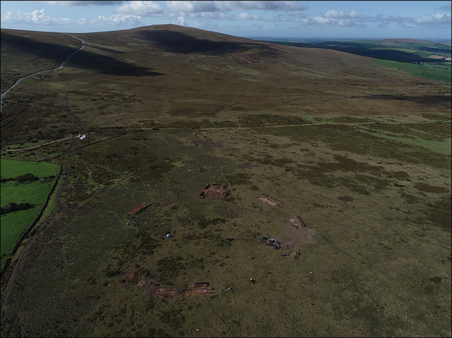
The majority of the stoneholes comprised shallow pits, 0.80–1.20m in diameter and 0.30–0.50m deep, with a shallow ramp up to 0.50m long. These contained stone packing around an emptied socket, which had subsequently filled with sediment following the removal of each standing stone. At the base of each socket an imprint of the monolith that once stood in it can be seen, preserving each stone’s basal shape and size. The largest of these (stonehole 91) preserves a pentagonal imprint, with four of the other holes preserve square of rectangular imprints.

Several stone tools were uncovered at Waum Mawn, including a flint scraper, a flint chip and a trimmed, circular mudstone disc. None of this material was directly datable, but the mudstone disc was made from a type of rock accessible within Neolithic levels at the Carn Goedog megalith quarry, which is about 5 km to the east of Waum Mawn. This is fairly typical of stone circles, which can be very hard to date, due to the small amount of associated material, and the fact that what material there is tends to be of types that do not lend themselves to radiometric dating. This problem is particularly acute at Waum Mawn, where the acid soil prevents the preservation of material made from bone. A small amount of charcoal, a material amenable to radiometric dating, was recovered by sediment flotation, was recovered, but the largest of these was under 4 mm long, making it likely that this material could have been moved from its original stratigraphic position by bioturbation. To attempt to remedy this, Parker Pearson et al. combined radiocarbon dating of these samples with optically stimulated luminescence dating of the sediments from which they were recovered. Optically stimulated luminescence dating can reveal the date at which a sample was last exposed to light; this potentially gives the date of burial, but can be reset if an object is subsequently exposed, making it unreliable on its own, but providing a plausible test for radiometric dating results.

Optically stimulated luminescence dating of samples from 11 feature profiles revealed a complex depositional history, with material from several exposures, possibly relating to the emplacement and removal of the megaliths, found within the sockets. Nevertheless, the material good internal stratigraphic coherence, with material likely to have been deposited in the Neolithic or Early Bronze Age.

The sediments from the holes yielded dates of between 6980 BC and 1900 AD, although the primary fills of the four sampled stoneholes, i.e. the deposits associated with the erection of the stone circle, are likely to have been deposited around 3530 BC, and the secondary fills, associated with the removal of the stones, were probably deposited around 2120 BC, although this date will not reflect the actual date of removal of the stones, but rather material that infilled the holes later, potentially at any time in the subsequent centuries or even millennia.
Radiocarbon dates were obtained from 43 charcoal samples recovered from Waun Maen, 31 from the stoneholes and 12 from other features. Most of these yielded Mesolithic dates, from the the ninth to fifth millennia BC, making them too old to be associated with the site, and were therefore discarded. Several more dates were rejected because they were too young, dating from the second and first millennia BC, i.e. the Bronze and Iron Ages. However, seven charcoal fragments, four of them from the postholes, yielded dates of 3600-3000 BC, i.e. the end of the Early Neolithic and beginning of the Middle Neolithic, dates which could plausibly relate to the construction of the site.
Such a date would place Waun Mawn amongst the earliest stone circles in Britain, alongside Long Meg and her Daughters in Cumbria (109m diameter) and the stone circle beneath the passage tomb of Bryn Celli Ddu on Anglesey (18m diameter). Radiometric dates obtained from a sample of Hazel charcoal recovered from one of the stoneholes of Long Meg and her Daughters dates to 3340–3100 BC, and cremated human remains obtained from pits associated with stoneholes at Bryn Celli Ddu have given radiocarbon dates of 3500–3100 and 3310–2900 BC, As no stone circle in Britain is currently thought to date to more than 3400 BC, Parker Pearson et al. suggest that the Waun Mawr stone circle was probably erected between 3400 and 3200 BC, and most likely towards the end of this range.
The three remaining stones at Waun Mawn are comprised of an unspotted dolerite, which may have come from the outcrops 3km to the south-east at Cerrigmarchogion on the Preseli ridge. A flake of rock left in the hole left by the standing stone with the pentagonal base is also made of this material.

Three of the stones of Stonehenge (stones 44, 45 & 62), are also made from unspotted dolerite bluestone, and one of these (stone 62) has a pentagonal cross-section at the turf line, which is similar in shape and dimensions to the imprint in stonehole 91 at Waun Mawn. Stones 44 and 45, which are undressed and form part of the outer circle at Stonehenge, are about 2 m high, similar in size to the single standing stone at Waum Mawn, at 1.20 m, but smaller than the two fallen stones, which are about 3.20 m long; stone 62, which stands about 2 m above the ground, would probably be almost as large as the fallen stones if its full length were exposed. The stones of Waum Mawn are therefore reasonably comparable with the stones of Stonehenge in terms of size.
Two of the stoneholes at Waum Mawn show no signs of having packing stones or ramps. One of these formerly held a short monolith 1.20m long, 0.90m wide and 0.25m thick, which is now recumbent at the east end of the arc, the second holds no stone, and is about 1.3 m to the east of the first. The long sides of these stones would have been perpendicular to the circumference of the circle, rather than parallel with it, forming what Parker Pearson et al. describe as a 'gunsight' on the north-east side of the circle, which possibly served as an entrance. To somebody standing in the centre of the circle during the Neolithic period, the Sun would have risen within this entrance on the Summer Solstice.

With a diameter of 110 m, Waum Mawn is the joint third largest stone circle in Britain (with the outer circle at Stonehenge), behind the outer circle at Avebury, at 331 m, and Stanton Drew, at 113 m, and ahead of Long Meg and her Daughters at 109 m, the Ring of Brodgar at 104 m, and the north and south circles at Avebury, at 104 m each. The inner circle of bluestone monoliths at Stonehenge was 87 m in diameter, with the stones carefully placed 4.5 m apart. This is quite different from the situation at Waum Mawn, where the stones are spaced irregularly, and where there are gaps in the perimeter where no stones were erected, particularly on the northwest side, although whether this was always the intention or whether the circle was not completed for some reason is unclear. Either way, the construction of Waum Mawn and Stonehenge appear to have been carried out with different emphasis and perspectives, with the regularity and homogeneity seen at Stonehenge being an inovation which was not present during the construction of the (older) Waum Mawn.
There are, however, still parallels with Stonehenge, notably the sighting of the putative entrance to Waum Mawn, in line with the Summer Solstice, which corelates with the setting of Stonehenge, which is positioned at the south-west end of a geomorphological landform of parallel ridges that coincidentally align on the solstitial axis. However, Stonehenge also appears to have an entrance aligned broadly with the northernmost major Moonrise, something which does not appear to have been marked at Waum Mawn.
The common diameter of Stonehenge and Waum Mawn, combined with the match between the cross section of stone 62 at Stonehenge and hole 91 at Waum Mawn, as well as the common building material (unspotted dolerite) used at both sites, strongly hints at a connection between the two ancient monuments.
Parker Pearson et al. believe there is a strong case for at least some of the material used at Stonehenge having originated at Waum Mawn, although they doubt that the stone circle at Waum Mawn ever contained 56 standing stones, the number suggested for Stonehenge by the Aubrey Holes. It is thought that about 80 bluestones were brought from Wales to Salisbury Plane in the Neolithic, with 56 going to Stonehenge and about 25 to the nearby Bluestonehenge circle. During Stonehenge stage two (2740–2505 BC) the site is thought to have comprised a double arc of standing stones, which were rearranged into an inner and outer circle at the onset of stage 3 (beginning in about 2400–2220 BC). During this last phase all of the original stones were re-organised, and the stones which had previously stood at Bluestonehenge incorporated into the new monument.
While the geology of the Waum Mawn stones matches that of some of the Stonehenge stones, this is not the case for the majority. Only three of the 44 bluestone stones at Stonehenge today are unspotted dolerite, compared to 27 spotted dolerite stones. Thus, while some of the Stonehenge material may have come from Waum Mawn, it is likely that the majority of the 80 original stones came from elsewhere. The Alter Stone at Stonehenge clearly did not come from Waum Mawn, or anywhere else in Preseli, and is thought most likely to have cone from the Devonian Senni Sandstone, about 100 km to the east. Two other sandstone pillars are thought to be of Palaeozoic origin, and to have come from the area to the north and east of Preseli. It is quite possible that these stones once formed part of other stone circles, which were dismantled in order to provide material for the construction of Stonehenge, as were other stones at the site with different lithologies.
It is unlikely that Waum Mawn is the Giants’ Dance described by Geoffrey of Monmouth. The common features seen at Waum Mawn and Stonehenge are sufficient to suggest that the stones were moved from one site to the other by people with a common purpose, not carried off as trophies of war following a military victory.
Recent strontium isotopic analysis on 25 of the approximately 60 cremation burials from Stonehenge has shown that four of these individuals had probably lived the last decades of their lives on the Ordovician/Silurian rocks of south-west Wales, the area that includes the Preseli Hills, with the remaining remains consistent with the individuals having lived on the chalk of Salisbury Plain or on the surrounding Mesozoic strata. Bone is remodelled repeatedly throughout our lives, with all our bone being replaced over a period of about a decade. This means that it is impossible, using bone as a test material, to detect the difference between a migrant who has lived in an area for more than a decade and a local who has lived their all their lives, so it is impossible to say if any of the other burials represent individuals who had moved to the area more than ten years before dying.
It is notable that the four individuals identified as being of southern Welsh origin have all been radiocarbon dated to around the very beginning of construction at Stonehenge, at about 3000 BC, when it is thought that the Bluestones were first erected, suggesting that these individuals might have relocated to the Salisbury Plain with the stones, while later burials reflect descendants of these migrants living on local chalk. This may even have applied to livestock as well as people. A sample of dentine from the mandible of an elderly Cow found in Stonehenge’s enclosing ditch has been dated to around 3350–2920 BC, and is has a strontium isotope signature consistent with the Animal having been reared in South Wales (unlike bone, dentine is laid down shortly before a tooth erupts, an is not replaced again within an Animal's lifetime.
No material at Waum Mawn has been dated to more recent than about 3000 BC, and very few items from the Preseli region in general. This is in spite of decades of research at Neolithic sites in the area. Waum Mawn did not go on to become the core of a larger monument complex, as happened to older stone circles at sites such as the Ring of Brodgar, Avebury and Stonehenge. Instead, the site seems to have been developed as a major centre in the earlier Neolithic, but then dismantled and abandoned. It is, however, unlikely that the area was completely depopulated, and the remaining stones at the circle may have remained in use in some way.
Stonehenge appears to have been built by Neolithic migrants from South Wales, whether on their own, or in collaboration with the local population. These migrants appear to have brought the large stones of the circle with them, possibly as a physical manifestation of their ancestral identities to be recreated in their new home. This brining of sacred stones to a new, mystically significant location may have helped to unify the people of southern Britain during the first phase of activity at Stonehenge.
Stonehenge lies upon a north–south line of henges, stone circles and cursuses (elongated parallel-sided enclosures) from the Thames Valley to the south coast of England, which broadly forms a geographic divide between different regional traditions in earlier Neolithic material culture, as well as variations in genetic ancestry between east and west, a location which has previously been cited as evidence for a unifying role for the monument.

The discovery of evidence for a potential migration of people and livestock from Wales to Salisbury Plain at the same time as the stones were relocated raises new questions about Stonehenge's origins and purpose. Why did these people move at this time? Was the movement driven by a change in climatic conditions, or was it driven by some economic, social or political change? Did people leave adverse conditions in Wales, or simply take advantage of some new opportunity on Salisbury Plane? Did they take over an older sacred site at Stonehenge? And if they did, was this an act of conquest, or unification (or both)?
See also...


Follow Sciency Thoughts on Facebook.
Follow Sciency Thoughts on Twitter.