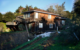
Three homes have had to be abandoned after a landslide at La Honda in San Mateo County, California this week. Home owners started to notice cracks in walls on Monday 23 January 2017, which grew during the next two days, till the road beneath the properties buckled on Wednesday 25 January. The properties have been red tagged (declared unsafe for habitation) by local authorities, leaving the homeowners unclear as to their future.
One of the properties in La Honda, California, that has been declared unsafe following a landslide this week. Aaron Kinney/Bay Area News Group.
The La Honda area is notoriously prone to landslips, which have apparently been happening for the last few thousand years, despite the overall relief of the area being quite low. These typically involve blocks of topsoil moving downslope after rainfall events, rather than deeper rock-events triggered by the state's complex seismic situation.
This week's incident happened after several weeks of heavy rainfall and winter storms that have affected much of California, with almost a meter of rain having fallen in the La Honda area already this month, and states of emergency being declared in 50 of the state's 58 counties. Landslides
are a common problem after severe weather events, as excess pore water
pressure can overcome cohesion in soil and sediments, allowing them to
flow like liquids. Approximately 90% of all landslides are caused by
heavy rainfall.
Road below the houses damaged by the January 2017 La Honda landslip. Josie Lepe/Bay Area News Group.
California has been battered by a succession of Pacific storms this winter, bringing widespread flooding and triggering a number of landslip and
subsidence events. This is due to exceptionally high temperatures over
the Pacific Ocean off the coast of the state this year due to a La Niña weather system over the southern Pacific; ocean
storms form due to heating of air over the sea, as
the air is heated the the air pressure drops and the air rises, causing
new air to rush in from outside the forming storm zone. If this zone is
sufficiently large, then it will be influenced by the Coriolis Effect,
which loosely speaking means the winds closer to the equator will be
faster than those further away, causing the storm to rotate, clockwise
in the northern hemisphere and anticlockwise in the southern hemisphere.
Whilst the high winds associated these storms is extremely dangerous, the real danger from such storms is often the flooding. Each millibar drop in air pressure can lead to a 1 cm rise in sea level, and large storms can be accompanied by storm surges several meters high. This tends to be accompanied by high levels of rainfall, caused by water picked up by the storm while still at sea, which can lead to flooding, swollen rivers and landslides; which occur when waterlogged soils on hill slopes lose their cohesion and slump downwards, over whatever happens to be in their path.
Whilst the high winds associated these storms is extremely dangerous, the real danger from such storms is often the flooding. Each millibar drop in air pressure can lead to a 1 cm rise in sea level, and large storms can be accompanied by storm surges several meters high. This tends to be accompanied by high levels of rainfall, caused by water picked up by the storm while still at sea, which can lead to flooding, swollen rivers and landslides; which occur when waterlogged soils on hill slopes lose their cohesion and slump downwards, over whatever happens to be in their path.
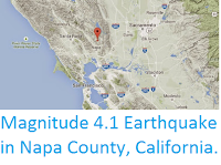
The approximate location of the January 2017 La Honda landslip. Google Maps.
The La Niña weather system is the opposite of the El Niño weather
system, in which unusually cold surface temperatures spread across the
equatorial Pacific from the upwelling zone on the South American coast.
This traps warm water from the western Pacific, preventing it from
spreading east and warming the central Pacific. This leads to lower
evaporation over the (cooler) east Pacific, leading to low rainfall on
the west coast of South America, and higher evaporation over the
(warmer) west Pacific, leading to higher rainfall over East and
Southeast Asia and northern Australia.
The effects of a La Niña weather system in December-February. NOAA.
This also leads to a breakdown in surface circulation in the North Pacific, which generally rotates clockwise, so that the same body of water stays off the coast of California, where it is constantly warmed by the Sun, leading to high levels of evaporation and onshore winds that bring high rainfall and flood events to the state.
The effect of the La Niña weather system on the weather of North America. NOAA.
See also...
Follow Sciency Thoughts on Facebook.


