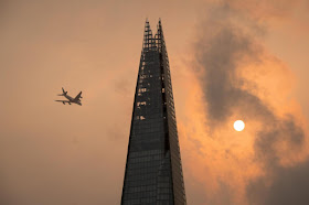
Much of the UK has been covered by a thick dust cloud today, reducing light levels and turning the sky an orange colour. The cloud was originally seen over the southwest of the country, and moved to the north and east.
Orange sky over London's Shard Building. Dominic Lipinski/PA.
The cloud is thought to have been caused by dust laden winds associated with former Hurricane Ophelia, a tropical storm over the Atlantic currently moving towards the UK. The dust is thought mostly to have originated from the Sahara; dust plumes from the Sahara frequently blow out over the Atlantic, and are a significant contributor to soils in the Amazon Basin, however these dust plumes are not generally blown back towards Europe unless an unusual wind pattern, such as that caused by Ophelia, crosses their path.
The path and strength of Hurricane Ophelia. Thick line indicates the
past path of the storm (till 3.00 pm GMT on Monday 16 October 2017),
while the thin line indicates the predicted future path of the storm,
and the dotted circles the margin of error at six and twelve hours
ahead. Colour indicated the severity of the storm. Tropical Storm Risk.
Tropical storms are caused by the warming effect of the Sun over
tropical seas. As the air warms it expands, causing a drop in air
pressure, and rises, causing air from outside the area to rush in to
replace it. If this happens over a sufficiently wide area then the
inrushing winds will be affected by centrifugal forces caused by the
Earth's rotation (the Coriolis effect). This means that winds will be
deflected clockwise in the northern hemisphere and anti-clockwise in the
southern hemisphere, eventually creating a large, rotating Tropical
Storm. They have different names in different parts of the world, with
those in the northwest Atlantic being referred to as hurricanes.
See also...
Follow Sciency Thoughts on Facebook.


