The Sahel Drylands spread across Africa to the south of the Sahara from Senegal in the west to Sudan in the east. The area suffered a series of severe draughts in the 1970s and 80s, but since then rainfall increased in both frequency and intensity, resulting in a steady greening of the area observed in satellite images. This increase in rainfall can be directly linked to rising global temperatures, with warmer air over the Atlantic Ocean leading to higher levels of evaporation there, and subsequently higher rainfall over Africa. However, the Sahel region is not a completely homogeneous environment, but rather is made up of a patchwork of dry grassland and woodland environments, which are likely to react to changing rainfall regimes in different ways, differences which may be beyond the capacity of satellites to detect without long-term terrestrial observation data for comparison, something which is absent in much of the region.
In a paper published in the journal Communications Biology on 23 April 2019, Martin Brandt of the Department of Geosciences and Natural Resource Management at the University of Copenhagen, Pierre Hiernaux of the Pastoralisme Conseil, Kjeld Rasmussen, also of the Department of Geosciences and Natural Resource Management at the University of Copenhagen, Compton Tucker of NASA's Goddard Space Flight Center, Jean-Pierre Wigneron of Interactions Sol Plante Atmosphère at the INRA Nouvelle-Aquitaine-Bordeaux Centre, Abdoul Aziz Diouf of the Centre de Suivi Ecologique, Stefanie Herrmann of Agricultural and Biosystems Engineering, at the University of Arizona, Wenmin Zhang, again of the Department of Geosciences and Natural Resource Management at the University of Copenhagen, Laurent Kergoat of Geosciences Environnement Toulouse at the Observatoire Midi-Pyrénées, Cheikh Mbow of START International Inc., Christin Abel, again of the Department of Geosciences and Natural Resource Management at the University of Copenhagen, Yves Auda also of Geosciences Environnement Toulouse at the Observatoire Midi-Pyrénées, and Rasmus Fensholt, once again of the Department of Geosciences and Natural Resource Management at the University of Copenhagen, present the results of a study of vegetation in the Sahel which used ground obsevation data from the fields sites run by the Centre de Suivi Ecologique in the Ferlo Region of north-central Senegal for comparison with satellite data.
The Ferlo Region covers much of northern Senegal, and has an extremely arid climate with a nine-month dry season when the climate is driven by dry winds from the Sahara and a rainy season that lasts from July to September, when moister air from the Gulf of Guinea brings irregular rainfall. The the Centre de Suivi Ecologique has routinely collected ecological data in the region since 1987, using a consistent methodology over more than three decades and measuring both woody and herbaceous vegetation properties over a series of 1 km transects.
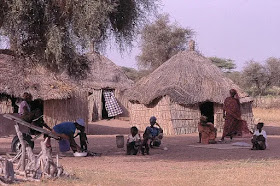
A village in the Ferlo Region of Senegal. Hôtel Cap Saint-Louis.
Brandt et al. used field data from the Ferlo to derive simple and reproducible metrics of vegetation composition, which was divided into above-ground herbaceous mass and woody plant foliage mass, across the Sahel, which was then compared to rainfall data. Rainfall was divided into core rainfall, which fell during the usual rainy season, and early/late rainfall, which fell outside of it.
The largest increases in rainfall measured across most of the Sahel were in early/late rainfall (i.e. rainfall that fell outside the typical rainy season), and this corresponded in most places to an expansion in woody plant foliage mass. Brandt et al.theorise that perennial woody plants were better able to utilise this out-of-season rain as most of the herbaceous plants have a very short growing season, starting their life cycle with the onset of the rains and finishing it as the rains end, with little potential to increase the length of their growing season.
Trends for the Sahel (1992–2012). (a) Vegetation optical depth estimated herbaceous mass trends. (b) Vegetation optical depth estimated woody foliage (trends. Significant (p less than
0.05) trends are shown in dark green and red, insignificant trends (p greater than 0.05) are shown in light red and green. (c) Areas where the slope in rainfall (early and late rains) is larger than the slope in rainfall (core wet-season rains) are shown in blue colour. d Pearson correlation between annual Vegetation optical depth 90% and pixel-wise fitted sinusoidal term (1st harmonic). (e) Core wet-season rainfall trend. (f) Early and late rainfall trend. Brandt et al. (2019).
0.05) trends are shown in dark green and red, insignificant trends (p greater than 0.05) are shown in light red and green. (c) Areas where the slope in rainfall (early and late rains) is larger than the slope in rainfall (core wet-season rains) are shown in blue colour. d Pearson correlation between annual Vegetation optical depth 90% and pixel-wise fitted sinusoidal term (1st harmonic). (e) Core wet-season rainfall trend. (f) Early and late rainfall trend. Brandt et al. (2019).
Significant increases in above-ground herbaceous mass were mostly located in the Ferlo and the northern Sahel of Mali. Areas with a significant increase in woody plant foliage mass are observed across the entire Sahel; notably in Senegal, Chad, eastern Niger and large parts of Mali. Decreases in both above-ground herbaceous mass and woody plant foliage mass were observed in western Niger and around Lake Chad, with no obvious relationship with rainfall, pointing towards other, rainfall independent causes (for example land management).
See also...
Follow Sciency Thoughts on Facebook.


