The Istituto Nazionale di Geofisica e Vulcanologia has reported a Magnitude 4.9 Earthquake at a depth of 1 km, roughly 2 km to the north of the city of Catania on the southeastern flank of Mount Etna, Sicily, slightly before 2.20 am local time (slightly before 3.20 am GMT) on Wednesday 26 December 2018. The Earthquake was felt across eastern Sicily and caused damage to buildings in the city, and about thirty people were injured, with ten requiring hospital treatment.
Damage to a house in Catania following an Earthquake on 26 December 2018. Reuters.
Earthquakes are often indicative of magma moving into new chambers beneath a volcano, and can be an indicator of major eruptions being imminent, though in this case the earthquake is part of a series that began two days previously and has been accompanied by some of the largest eruptions on the volcano for a decade.
The approximate location of the 26 December 2018 Earthquake. USGS.
Etna first erupted about half a million years ago, beneath the sea off
the east coast of Sicily, and has been going strong ever since. It now
stands 3330 m above sea level, and covers 1200 km³. It is responsible
for fertile soils across eastern Sicily. Records of eruptions on Etna go
back to 1500 BC. It is Europe's second largest volcano, after Teide in
the Canary Islands, and is one of the most active volcanoes in the
world.
Smoke from Mount Etna over the city of Catania on Wednesday 26 December 2018. AFP.
Despite all this Etna has only ever
caused 77 recorded deaths (the most recent being two tourists caught in a
summit explosion in 1987) and relatively little destruction. In 1928 it
destroyed the village of Mascali on its northeastern flank, though
there were no reported casualties, the village being slowly overrun by a
lava flow. In 1669 a much larger lava flow destroyed at least 10
villages, reaching the walls of the city of Catania, 40 km to the south,
but again without loss of life. In 122 BC a heavy ash fall covered much
of the region, causing several buildings to collapse in Catania. The
destruction was deemed so severe by the Roman authorities that they
granted the city a 10 year tax holiday. In about 6000 BC a landslide on
the eastern flank of the volcano is thought to have caused a tsunami
that caused destruction around much of the eastern Mediterranean.
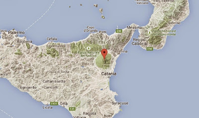
The location of Mount Etna. Google Maps.
Etna
is located on the border of the African and European Plates,
specifically where Africa is being subducted beneath the European Plate.
As it is drawn into the Earth's interior material from the African
Plate melts, and the lighter portions rise up through the overlying
European Plate, causing a number of volcanoes including Etna and
Vesuvius.
Map showing the tectonic plates underlying Italy and southern Europe, and the location of the l'Aquila Earthquake. Napoli Unplugged.
Witness
accounts of Earthquakes can help geologists to understand these events,
and the structures that cause them. The international non-profit
organisation Earthquake Report is interested in hearing from people who may have felt this event; if you felt this quake then you can report it to Earthquake Report here.
See also...
Follow Sciency Thoughts on Facebook.


