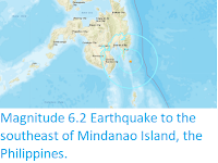
The Philippine Institute of Volcanology and Seismology recorded a Magnitude 6.4 Earthquake at a depth of 63 km about 80 km
off the southeast coast of Mindanao
Island, Philippines, slightly 3.00 pm local time(slightly after 2.00 am GMT) on Sunday 29 September 2019. There
are no reports of any damage or casualties associated with the event,
but it was felt across the southern Philippines and central Indonesia.
The approximate location of the 29 September 2019 Mindanao Earthquake. USGS.
The geology of the central Philippines is Complex. The west of Mindanao
Island is located on the Banda (or Sunda) Microplate, and the east on
the Philippine Plate, which is being subducted beneath the Sunda (or
Banda) Microplate along the central part of the island. Immediately to
the east of the Island the Pacific Plate is being subducted along the
Philippine Trench, and passes beneath eastern Mindanao as it sinks into
the Earth. This is not a smooth process, an the plates constantly stick
together then break apart again as the pressure builds up, resulting in
Earthquakes.
Subduction beneath the Philippines. Yves Descatoire/Singapore Earth Observatory.
Witness
accounts of Earthquakes can help geologists to understand these events,
and the structures that cause them. The international non-profit
organisation Earthquake Report is interested in hearing from people who may have felt this event; if you felt this quake then you can report it to Earthquake Report here.
See also...
Follow Sciency Thoughts on Facebook.


