Pages

Tuesday, 31 January 2012

Water in the stratosphere of Jupiter.

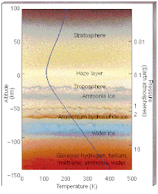
Jupiter, and the other giant planets of our solar system, trap water in their tropospheres. Any water vapor rising in the troposphere will condense out at a set point in the atmospheric layer, forming clouds and eventually falling as rain. Exactly how much and how high this happens will vary, depending on how warm the planet is (cold Neptune probably doesn't have to much water vapor to start with), but no (or very, very little) water should be able to escape the troposphere into the overlying stratosphere. Yet the Infrared Space Observatory and the Spitzer Space Telescope have been able to detect water in the stratospheres of all the giant planets, leaving scientists to speculate as to how it got there.

The atmosphere of Jupiter; water condenses out far below the bottom of the stratosphere.

In the absence of a theoretical model that can explain how water might rise into the Jovian stratosphere from bellow, planetary scientists assume that it must come from above arriving from space into the top of the atmosphere and working its way downwards through the layers of the Jovian atmosphere. In 1994 the comet Shoemaker-Levy 9 gave a good demonstration of one way in which this could happen, as it passed close to the giant planet, was torn apart by it's gravity, and finally plunged into the Jovian atmosphere in a series of impacts. But not everyone was completely convinced by this Shoemaker-Levy 9, like most comets, is thought to have been composed largely of water-ice, and certainly entered the Jovian atmosphere from above, but it was traveling at quite a speed, and so not much of it may have stayed in the upper atmosphere. Some scientists favor a different model for the arrival of water in the Jovian atmosphere, suggesting that of occasional big inputs of water, Jupiter may instead receive a steady flow of frozen space dust, from the trails of comets that have crossed its path (which would be a lot more abundant at Jupiter's orbit than it is at Earth's).

Animation of Shoemaker-Levy 9 plunging into Jupiter. ESA/Hubble.

In a forthcoming paper in the journal Planetary and Space Science, a team lead by Thibault Cavalié of the Max Planck Institute for Solar System Research, the Observatoire Aquitain des Sciences de l'Univers at the Université de Bordeaux and the Laboratoire d'Astrophysique des Sciences de Bordeaux present the result of a six year study into the Jovian atmosphere using the Swedish Odin Space Telescope, from 2003-9, combined with earlier data from 1999-2002, giving a ten year dataset.

Artist's impression of Odin. From the University of Calgary.

In theory if the water in Jupiter's stratosphere was delivered by rare commit impacts then it would fall steadily over the period of the study, as the water delivered by Shoemaker-Levy 9 was lost to diffusion into the lower atmosphere and photodissociation into hydrogen and oxygen (in the upper atmosphere of planets - including Earth - molecules are easily split into their constituent atoms by solar radiation), eventually disappearing completely about 15 years after the impact. If Jupiter receives its water from frozen, icy, space-dust, then the level of water in the atmosphere should have remained more-or-less constant during the period of the study.

In the event the level of water did fall over the period of the study, at a rather faster rate than predicted by the model. This suggests that Jupiter does in fact get the water in it's stratosphere from cometary impacts, but that we still do not have a full understanding of the processes in the Jovian atmosphere.

Cavalié et al. also note that in July 2009 another object was seen to collide with Jupiter, though since this object was not observed before the collision, it is unclear whether it was a (stoney) asteroid or an (icy) comet. In theory it ought to be possible to deduce the nature of this object by studying the evolution of the Jovian stratosphere.

Hubble image of the Southern Hemisphere of Jupiter after the 2009 impact; the large black mark is the impact site. NASA/ESO.

Cadmium spill on Longjiang River threatens water supplies to several Chinese cities.

On 15 January 2012 authorities in Guangxi Province in Southern China detected high levels of cadmium metal in the Longjiang River, after investigating reports of hundreds of dead fish in Hechi City. Cadmium levels were reported to be about 0.025 mg/l­ˉ³ (0.025 milligrams per liter) five times the official permitted safety levels. Cadmium, which is used in batteries, poses a serious threat to health; it is a carcinogen and can cause damage to the kidneys, liver, respiratory system and skeleton, and can be a persistent pollutant in water systems as it is hard to flush out. As well as Hechi the spill threatens the water supplies of Luijiang and Luizhou cities, with populations of 1.5 and 3.7 million respectively. There are reports of panic-buying of bottled water in Luijiang, and it is unclear if the 350 000 tons of water held in underground reserves at Luizhou would be enough to ride out the crisis. At the time of writing there have not been any reports of poisoning due to the incident.

The location of the Longjiang River, with the area effected by the spill highlighted in red. Zhang Ye/China Daily.

Authorities responded by releasing 500 million cubic meters of water from the Honghua Hydropower Station and mobilizing Police and Army personnel to pour polyaluminium chloride into the river as a neutralizing agent.

Officers from the Liuzhou brigade of the Armed Police Force pouring polyaluminium chloride into the Lomgjiang River on 29 January 2012. Xinhua News Agency.

On 25 January officials began investigating the Guangxi Jinhe Mining Co. in Hechi as the most likely source of the contamination. The company mines zinc in the city, and has failed repeatedly failed government inspections of its waste disposal procedures. Since cadmium is a common by-product of zinc mining the mine was an obvious target for suspicion. However 31 January local environment officials released a statement to the effect that they had arrested seven executives from chemical plants in Guangxi. It is unclear if this means the Jinhe Mine has been exonerated, if the investigation has been widened, or if officials are being deliberately vague to avoid prejudicing any future prosecution. Officials have also reported that seven mines and factories in have been closed as a precaution.

An environment official collecting samples from the Longjiang River in Luizhou. Reuters.

In the past three decades China has undergone an unprecedented process of industrialization, and has suffered many environmental problems as a consequence. In the past environmental groups have accused the country of turning a blind eye to environmental issues, in order to promote economic growth. However in the past few years Chinese authorities have shown signs of taking the environment much more seriously, after a string of pollution incidents with health implications, which have lead to public outcries.

Large Earthquake near Ica, Peru.

Slightly after ten past midnight local time (slightly after 5.10 am GMT) on Monday 30 January 2012, an Earthquake measuring 6.3 on the Richter Scale occurred 15 km to the southeast of the Peruvian city of Ica at a depth of 39.2 km, according to the United States Geological Survey. This is quite deep, but 6.3 is a big Earthquake, and the effects were felt quite severely in the city and surrounding area.

Map showing the location of the quake, and the areas where it was most intensely felt. From the United States Geological Survey.

There are no reports of any fatalities, but the Earthquake-Report website is reporting 145 people injured, 12 of them seriously. In addition they are reporting 581 people have been made homeless and 762 living in damaged buildings, with two houses completely destroyed, 125 uninhabitable, and a further 150 damaged but still in use. There are also some reports of looting.


Raw video from the scene of the quake. Associated Press.

Peru is on the West Coast of South America, on the margin between the South American and Nazca Plates. The Nazca Plate, which underlies part of the Southeast Pacific, is being subducted beneath the South American Plate. This is not a smooth process, and the plates often stick together, adhering for a while as pressure builds up (the Nazca Plate is being pushed eastwards by an expansive centre under the Pacific, the South American Plate is being pushed westwards by an expansive centre under the Atlantic), then shifting abruptly, causing Earthquakes. As the Nazca Plate is drawn into the Earth's interior, it partially melts, and some of the melted material rises up through the overlying South American Plate, causing volcanoes in the Andes, but also leading to the mineral richness of much of the area.

Diagram showing the subduction of the Nazca Plate beneath the South American Plate, and the effects thereof. The green star represents an Earthquake. From the Pacific Earthquake Engineering Research Center.

Sunday, 29 January 2012

A Pachycormiform Fish from the Lower Jurassic Posidonia Shale.

The Pachycormiform Fish were large Teleost (Ray-finned) fish from the Mesozoic. One group of these fish appears to have taken up filter-feeding, and reached very large sizes, at least 8m, with estimates for one species (Leedsicthys) of up to 27 m (bigger than an average, though not the largest, Blue Whale). The non-filter-feeding members of the group were pelagic predators superficially resembling modern Barracuda.

Issue 279 of the Proceedings of the Royal Society B contains a paper by Matt Friedmann of the Department of Earth Sciences at the University of Oxford, reexamines a Pachycormiform Fish from the Lower Jurassic Posidonia Shale of Southern Germany. This fish, Ohmdenia multidentata, is known from a single fragmentary skeleton held at the Institut für Geowissenschaften at Eberhard Karls Universität Tübingen. It is thought to be the sister species to the filter-feeding Pachycormiform Fish, that is to say the closest relative of the group that is not actually a member of it.

Ohmdenia multidentata. (a) Specimen photograph. (b) Interpretive drawing. (c) Reconstruction. Belemnites associated with abdominal region are shaded in grey and marked with an asterisk (‘*’) in (b). a.f, anal fin; ang, angular; c.f, caudal fin; cle, cleithrum; den, dentary; ?epb, possible epibranchials; hym, hyomandibular; ipb, infrapharyngobranchial; max, maxilla; op, opercle; p.f, pectoral fin; pop, preopercle; qu, quadrate; rad, pectoral radial; sang, surangular; scl, supracleithra; sclr, sclerotic ring. From Friedmann (2012).

Ohmdenia lived at the same time as the earliest filter-feeding Pachycormiforms, but as there closest relative still has the potential to shed light on how their ancestors lived. Unlike most non-filter-feeding Pachycormiforms, which had needle or blade-shaped teeth, Ohmdenia had blunted teeth, of a type usually associated with a diet of soft-bodied cephalopods (squid and octopus), suggesting that switching to such a diet may have been a stage on the way to filter-feeding.

Friedmann also suggests that such a change in diet may have occurred in other groups that have switched from a pelagic predatory diet to a filter feeding one, such as whales and sharks.

A new study of XO-2b, a planet in a wide binary star system.

The planet XO-2b was the second planet discovered by the XO Telescope on Haleakala Volcano on Maui, Hawaii, in 2007. It orbits a K-type Orange Dwarf Star with a mass 98% of that of our sun, 480 light years from Earth in the Lynx Constellation. This star (XO-2) has a binary companion (XO-2S) of similar mass at a distance of about 4600 AU (4600 times the distance between the Earth an the sun), the two orbiting about their mutual centre of gravity. The planet itself was determine to have a mass 57% of that of Jupiter and 98% of its radius, and to orbit the star at a distance of 0.0639 AU (or 6.39% of the distance between the Earth and the Sun) every 63 hours. The planet has a similar radius to Jupiter despite it's much lower mass due to the heat it receives from the close-by star, which causes it to expand; it is much less dense than Jupiter as a consequence.

An artist's impression of XO-2b (right), with Jupiter for scale. Ignacio González Tapia.

The 25 December 2011 edition of the Publications of the Astronomical Society of Japan contains a paper by a team lead by Norio Narita of the National Astronomical Observatory of Japan, describing an attempt to find out if the binary companion effects the orbit of XO-2b. The team made additional observations of the XO-2 system using the Subaru 8.2 m Telescope on Mauna Kea and previously published data from the Fred Whipple Observatory in Arizona.

The team made a revised estimate of the size of the planet, coming up with 62% of the mass of Jupiter. They found that XO-2b has a very slight eccentricity and orbited in the plane of the system (rather than tilted at an angle), had a prograde orbit, and slowed down and speeded up slightly in the course of this orbit, indicative of the gravitational influence of another body in the system. However this perturbation could not easily be attributed to the presence of XO-2S, since it appears to be caused by a body with an orbital period of about 8 years, implying that it orbits at most about 4 AU from XO-2 (Jupiter obits our Sun at a distance of 5.2 AU, every 11 years). They concluded that there was probably a second planet in the XO-2 system. This does not preclude any influence of XO-2S on the orbit of XO-2b, but suggests that it is two small to have been detected by this study.

Saturday, 28 January 2012

Ubehebe Crater; a seventh potentially active volcano in California.

California is generally considered to have six potentially active volcanoes, Medicine Lake, Mount Shasta, Lassen Peak, Clear Lake, the Long Valley Caldera and Cosco Peak. The Ubehebe Crater in Death Valley has always been assumed to be an ancient feature, the result of a phreatomagmatic explosion; an explosion that occurred when rising magma encountered subterranean water, causing the water to vaporize instantly and leading to an explosion that blew rocks over the floor of the valley. There are several smaller craters nearby that appear to have similar origins. Since Death Valley is thought to be a very dry place, it was always assumed that the explosions took place long in the past, when the valley had a wetter climate.

How a phreatomagmatic explosion created the Ubehebe Crater. From Jake McDonald's Dessert Southwest Capstone 2007 Trip Page.

On 18 January 2012 a paper published in Geophysical Research Letters by a team from the Department of Earth and Environmental Sciences at Columbia University led by Peri Sasnett, describes a new study of the Ubehebe Crater, which suggests that it may have been formed much more recently, and that further activity at the site could happen again at any time.

The team used a method developed to date moonrocks, which relies on detecting isotopes created by cosmic rays hitting rocks at the surface to determine how long had passed since the rocks were exposed. To their surprise they discovered the most recent explosion must have occurred about 800 years ago, at a time when Death Valley was even hotter and drier than it is now.

Ubehebe Crater.

This has two implications. Firstly, it is clearly not to dry in Death Valley for phreatomagmatic explosions. Actually this is not too much of a surprise. There is still groundwater deep beneath the surface of Death Valley, and the idea condition for phreatomagmatic explosions is quite dry; if there is too much water it will tend to swamp the explosion, reducing the size of the eruption. Secondly, magma has been rising towards the surface of Death Valley much more recently than had been realized, and therefore this could happen again.

Authorities at Death Valley National Park are relaxed about the study; it is unlikely that any explosion would happen without warning, so they do not have to worry about accidentally blowing up tourists, and none of the prior eruptions have been big enough to cause damage beyond their immediate vicinity. They have far more to worry about from car accidents and tourists getting heat exhaustion.

Volcanism on the West Coast of North America are fed by the subduction of the Juan de Fuca Plate beneath the North American Plate. As the subducting plate sinks into the Earth's interior it is heated by the heat of the planet's interior. Some of the melted material then rises up through the overlying North American Plate, forming volcanoes at the surface.

Diagram showing how the subduction of the Juan de Fuca Plate causes volcanism on the West Coast of North America. From the United States Geological Survey.

The Penguins of Africa.

A single species of Penguin, Spheniscus demersus, or the Blackfooted Penguin, lives in Southern Africa today, though two species, Nucleornis insolitus and Inguza predemersus are known to have lived there in the Early Pliocene. It has generally been assumed that the modern Penguins are descendants of the fossil penguins, though since they are also clearly closely related to other Penguins of the genus Spheniscus, which live in South America and the Galapagos, it is difficult to say what the exact relationship is.

Issue 279 of the Proceedings Of The Royal Society B contains a paper by Daniel Ksepka of the Department of Marine, Earth and Atmospheric Sciences at North Carolina State University and the Department of Zoology at the University of Cape Town and Daniel Thomas of the Department of Paleontology at North Carolina Museum of Natural Sciences in which they describe the results of a thorough investigation into South Africa's Penguins and the conclusions derived from this.
Reconstruction of the Pliocene Penguin Inguza predemersus (right) with a modern Blackfooted Penguin (left) for scale. From Ksepska and Thomas (2012).


Ksepska and Thomas examined over 200 fossil Penguins from the Iziko South African Museum collections, and compared them to recent and fossil penguins from South Africa and elsewhere. The came to the conclusion that modern Blackfooted Penguins are closely related to the Chinstrap Penguins of South America and the Galapagos, but not closely related to either of the fossil Penguins, and certainly not descended from either. Nor are the two extinct forms closely related.

This means that Penguins have invaded Africa on at least three separate occasions, something that Ksepska and Thomas examined next. Penguins appear first in the fossil record of New Zealand, but by the end of the Eocene are widespread in Antarctia, Australia and South America. They do not appear in Africa until the Early Pliocene, 30 million years later, and have never reached Madagascar of the Northern Hemisphere.

The inability of Penguins to colonize the Northern Hemisphere is the easiest to explain. Currents around the equator tend to flow away from it; in the Northern Hemisphere to the north and in the Southern Hemisphere to the south. There are also strong thermoclines to cross; water forms 'streams' within the ocean (such as the Gulf Stream) dependent on temperature, things flow easily within these streams, but it is hard to cross from one to the other. Similarly Madagascar is separated from Africa by the strong Agulhas Current, which sweeps away from Madagascar.

Africa can be reached from South America by the South Atlantic Current and the Antarctic Circumpolar Current, but these currents have not always flowed on their current paths. Prior to the Pliocene Antarctica and South America were still connected together; the Antarctic Peninsula was attached to the tip of Patagonia. This stopped the flow of the Antarctic Current, and trapped Penguins in the South Pacific. After the continents broke apart the Penguins were free to colonize the South Atlantic and soon reached Africa.

Map of the South Atlantic showing the prevalent currents and fronts. Dots show the location of modern Blackfooted Penguin colonies, and open stars locations where fossil Penguins have been found. From Ksepska and Thomas (2012).

Next Ksepska and Thomas looked at the extinction of the Pliocene Penguins. It is of course impossible to state the exact causes of such extinctions with absolute confidence, but this does not stop scientists from attempting to come up with plausible scenarios. During the Early Pliocene the sea-level was about 90 m higher than it is now. At the end of the Early Pliocene it dropped sharply, due to the increasing glaciation of Antarctica; another consequence of the separation of South America and Antarctica, which enabled the developing Circumpolar Current to isolate the southern continent in its own climatic zone, and caused the temperature to plummet. Ksepska and Thomas theorize that the Pliocene African Penguins may have been dependent on offshore islands as breeding grounds, and that either the falling waters left them vulnerable to African predators that they were unable to cope with, or that fluctuating sea levels associated with the changing climate left them unable to find safe nesting sites.


Earthquake shakes Yamanashi Prefecture, Japan.

Slightly before 7.45 am on 28 January 2012 local time (slightly before 10.45 pm on 27 January, GMT) an Earthquake shook the Yamanashi Prefecture in Japan, and was felt in surrounding areas. The quake was recorded as measuring 5.5 on the Richter Scale by the Japan Meteorological Agency, and as occurring at a depth of about 20 km. The quake was followed after a few minutes by an aftershock measuring 4.1 on the Richter Scale, also at a depth of 20 km. There are no immediate reports of any casualties or serious damage.

Map of the effected area from the Japan Meteorological Agency (red cross). The colours refer to the intensity of shaking, higher numbers indicate more severe shaking.

Japan lies on the boundary between four tectonic plates, the Eurasian, Philippine Sea, Pacific and North American. Yamanashi Prefecture is in the Yatsugatake Mountains, which lie over the border between the Eurasian and Philippine Sea Plates. The Philippine Sea Plate is being subducted beneath the Eurasian Plate in the Nankai Trench to the south of Honshu Island. As it passes under the island it sticks to the underside of the Eurasian Plate, causing the overlying plate to crumple, and forming fold mountains. This causes periodic build ups of pressure, which are released in Earthquakes. In addition as the Philippine Sea Plate sinks into the Earth, it is melted by the heat of the planet's interior. When this happens some of the melted rock rises up through the overlying Eurasian Plate, leading to the formation of volcanoes in the Yatsugatake Mountains.

Map of Japan showing the plate boundaries. The Yatsugatake Mountains are part of the SW Japan Arc.

Friday, 27 January 2012

HAT-P-38b, the most Saturn-like exoplanet discovered yet.

To date over 700 planets have been discovered outside our own solar system, a number that seems to grow every day. The majority of these planets are Jovian or super-Jovian planets; a category that includes everything bigger than 40% of the mass of Jupiter. The next most common category are super-Earth or Neptune sized planets, with less than 10% of the mass of Jupiter. We have even discovered a small number of Earthlike planets, of similar size to our planet, or a little smaller. Planets of a similar size to Saturn, between 10% and 40% of the size of Jupiter, are relatively unusual.

This is thought to be largely a product of our sampling methods. Very large planets are easy to detect, since their gravity effects their host stars, causing them to wobble as the planets move around them. Planets close to their stars are also fairly easy to observe, since they transit their stars quite often, causing regular dips in the light output of the star that we can detect. Thus the planets we detect the most easily are very large planets close to their stars, planets we suspect are quite unusual, but which we find readily. Conversely we suspect that planets of similar size to Saturn in similar orbits are fairly common, but this does not make them any easier to find. Saturn-sized planets close to their stars do not appear to be common, but this is not unexpected.

On 24 January 2012, a paper appeared on the arXiv online database at Cornell University Library, in which a team lead by Bun'ei Sato of the Department of Earth and Planetary Sciences at the Tokyo Institute of Technology, describing the discovery of a planet orbiting the star GSC 2314-00559. The paper has also been accepted for publication in the Publications of the Astronomical Society of Japan. The discovery was made using the Hungarian-made Automated Telescope Network (HATnet) which uses telescopes at the Fred Whipple Observatory in Arizona and at the Smithsonian Astrophysical Observatory in Hawaii and back up observations made using Subaru Telescope of the National Astronomical Observatory of Japan, also in Hawaii.

The Subaru Telescope.

GSC 2314-00559 is a G-type yellow dwarf star 812 light years from Earth. It has 89% of the mass of our Sun, and 92% of its radius; it is thought to be about 1.7 billion years old. As the 38th star hosting a planet discovered by the HATNet Project it has been renamed HAT-P-38. Orbiting this at a distance of 0.0523 AU (5.23 % of the distance at which the Earth orbits the Sun, or 13.4% of the distance at which Mercury orbits the Sun) is HAT-P-38B, a planet with 26.7% of the mass of Jupiter and 82.5% of its radius. The planet is highly irradiated due to the nearness of the star, with an estimated equitorial temperature of 1082 K, compared to 134 K for Saturn. Despite being so strongly heated, HAT-P-38b has an average density of 0.59 g cmˉ³, compared to 0.687 g cmˉ³ for Saturn (heated to the same temperature, Saturn would expand considerably, lowering its average density), suggesting that the overall makeup of the planet is not that similar to Saturn; Sato et al. suggest a large rocky core may be raising the overall density.


Asteroid 2012 BX34 to pass within 59 000 km of Earth.

On 27 January 2012, at approximately 3.30 pm GMT, Asteroid 2012 BX 34 is will be at its closest point to Earth on its current orbital cycle, passing within 59 000 km of the Earth (the Moon never comes within 370 000 km of the Earth). It is not thought likely that it will hit us, as it is too small (11m across) to survive the trip through our atmosphere. An asteroid would have to be about 140 m across to cause significant damage at the impact sight, and a lot larger still to cause global effects.

A diagram showing the orbit of 2012 BX34. NASA/JPL-Caltech.

2012 BX34 was discovered earlier this year by NASA's Asteroid Watch program (the name means the 873rd asteroid discovered in the second half of January 2012). The program is intended to search for near-Earth objects large enough to do us harm, but (obviously) it finds plenty of smaller objects in the process. To date the project has detected 911 objects large enough to be a potential threat, though none of these is predicted to collide with the Earth in the near future.

Thursday, 26 January 2012

A modern turbidite deposit from the Mediterranean Coast of Spain.


Turbidites are sedimentary rock formations formed by submarine landslides. They are very distinctive, as water is very efficient at separating sediments by particle size, since larger, heavier particles will sink rapidly but smaller, lighter particles will remain in suspension for longer, taking more time to settle out. The upshot of this is that turbidite deposits show a clear gradation of particle sizes, with large particles at the base and a steady decrease in particle size moving up the stratigraphic column; smaller, finer debris will also spread further out, giving a horizontal grain size distribution as well as a vertical one. Turbidites are valued by sedimentary geologists, as they are distinctive and tend to cover wide areas, helping to build a clear picture of the geology of a region. They are prized even more highly by palaeontologists, as they often contain excellent fossils, since organisms can be buried rapidly, helping them to enter the fossil record. For example the famous soft bodied Cambrian fossils of the Burgess Shale come from turbidite deposits.

In a paper published in the journal PLoS One on 25 January 2012, a team lead by Anna Sanchez-Vidal of the Grup de Recerca Consilidat (GRC)-Geociències Marines, Departament d'Estratigrafia, Paleontologia i Geociències Marines at the Universitat de Barcelona, describe the results of a storm on the Mediterranean Coast of Spain on 26 December 2008.

The storm was the largest recorded in 25 years of monitoring on the section of coast, though anacdotal evidence suggests that storms on a similar scale occurred on the same coast in the nineteenth and early twentieth centuries, when formal weather records were not being kept. The storm progressed for about 1000 km in a northwest-to-southeast direction along the Catalan Coastal Shelf, causing widespread shore erosion and coastal flooding. On the continental shelf it caused scouring of the seabed, and severe disruption to seagrass, brown algae (seaweed) and gorgonian (soft coral) communities.

Map of the effected area, from Sanchez-Vidal et al. (2012).

In the Blanes Canyon, at the western end of the effected area, where sedimentation was being monitored, there was strong increase in the current speed through the canyon, followed by a marked increase in the grain size of particles being deposited at the shallower end of the canyon. This was accompanied by a marked increase in turbidity in the water throughout the canyon. Finally there was an increase in the deposition rate for fine particles throughout the canyon.

Dodecanese Islands and Crete shaken by Earthquake.

At approximately 6.25 am local time (4.25 am GMT) on Thursday 26 January 2012 an Earthquake in the Aegean Sea to the north of Crete and west of the Dodecanese Islands was felt in both areas. The Quake was recorded by the Hellenic Unified Seismological Network as measuring 5.3 on the Richter Scale and occurring at a depth of 30 km, and by the United States Geological Survey as measuring 5.2 on the Richter Scale and occurring at a depth of 18 km. The quake has been followed by a series of aftershocks, some of which have exceeded magnitude 4.0 on the Richter Scale. Neither the original quake nor the aftershocks are reported to have caused any significant damage, nor casualties

Map showing the location of the main quake, from the United States Geological Survey. Pink line south of Crete is the boundary between the Aegean Sea Plate and the African Plate.

Crete is located on the southern edge of the Aegean Sea Plate, a small tectonic plate being forced southwest by the eastward motion of the Anatolian Plate, which underlies Turkey. Immediately to the south the African Plate is moving northward, creating a convergent margin. The African Plate is being subducted beneath the Aegean Plate in the Hellenic Trench, passing under Crete and the Aegean. This is not a smooth process, the rocks stick to one-another, then periodically move suddenly when the pressure becomes to great, causing Earthquakes.

Diagram showing the subduction of the African Plate (left) under Crete (right).

The subduction zone also leads to volcanism in the Dodecanese, as rocks from the African Plate are melted by the heat of the Earth's interior and rise up through the overlying Aegean Sea Plate, forming the volcanoes of Gyali, Santorini, and Nysiros, as well as a number of submarine volcanoes. This has lead to some catastrophic incidents in the past, most notably the destruction of the ancient Minoan civilization of Crete by a tsunami triggered by an explosion in the Santorini Caldera.

An artist's impression of a Minoan city being inundated by the Santorini Tsunami.

Earthquakes have also taken their toll on life in the Aegean over the millennia, and are a more regular threat. Earthquakes on Crete have three times (365 AD, 1303 and 1810) caused tsunamis that have led to devastation on the Egyptian Coast. On the Boundary with the Eurasian Plate the cities of Sparta, Corinth and Athens have all been devastated by Earthquakes on various occasions, as has Rhodes, on the boundary with the Anatolian Plate, most famously in 226 BC, when a quake destroyed the famous Colossus, a giant statue that stood at the entrance to the harbor.

See also Earthquake in the Gulf of Corinth, and Earthquakes on Sciency Thoughts YouTube.

A living fossil eel discovered in Palau.

Eels first appear in the fossil record about 100 million years ago, in the Mid Cretaceous. These Cretaceous forms are primitive compared to modern forms, with incomplete fusion of the dorsal, caudal and anal fins, scales on their bodies and many of the bones lost or fused still present. However they are still clearly eels, with elongate bodies and the loss and fusion of some bones associated with the group, in particular the gill rakers and the pectoral fins.

Volume 279 of the Proceedings of the Royal Society B (Biological Sciences) contains a paper by a team lead by David Johnson of the Division of Fishes at the National Museum of Natural History at the Smithsonian Institution, describing the discovery of a remarkable living fossil eel from a submarine cave in a coral reef fringing Ngemelis Island, part of the Pacific Ocean Republic of Palau. This eel shows many features in common with Cretaceous eels, and has been named Protanguilla palau (the first/earliest eel from Palau).

Protanguila palau. Top, adult female named as the Holotype, 176 mm in length. All other pictures of juvenile specimen named as Paratype. Top centre, whole specimen, 65 mm in length, scale bar is 5 mm. Left centre, head in lateral view, scale bar is 5 mm. Right centre, head in ventral view, scale bar is 2 mm. Bottom left, close up of left gill opening in ventral view, scale bar is o.5 mm. Bottom centre, stained scales on lateral body-line, scale bar is 0.5 mm. Bottom right, close up of scales, scale bar is 0.5 mm. From Johnson et al. (2012).

Protoanguila palau shows many similarities to Cretaceous eels, it has an unfused palette, incompletely fused fins, and retains its scales and some bones lost in modern eels. In addition it shows some features lost in even Cretaceous eels, it retains its gill rakers, and whilst clearly an eel, lacks the elongate form found in all other eels. Gene sequencing of P. palau confirms that while it is more closely related to eels than any other fish, all other eels are more closely related to one-another than they are to P. palau.

Based upon this Johnson et al. suggest that P. palau is a living fossil, which branched off from other eels at some time around the boundary between the Triassic and the Jurassic, and has been living in isolation ever since. Whilst this seems fairly reasonable (the date is suspiciously precise, 'before the Mid Cretaceous' would have been more defensible), Ngemelis Island is a coraline limestone platform on top of an extinct submarine volcano - a feature that is unlikely to have remained unaltered since the Mesozoic. This implies that P. palau must have migrated here some time in the more recent past, and may well have relatives elsewhere in the West Pacific.

See also New Mouse Lemur discovered in Madagascar and Boney Fish on Sciency Thoughts YouTube.

Wednesday, 25 January 2012

Was Archaeopteryx black?

Archaeopteryx lithographica was an early bird living in Northern Europe in the Late Jurassic, about 150 million years ago. In the mid-to-late-nineteenth century several complete and partial specimens were discovered in the Solnhofen Limestone in Bavaria, when it was hailed as both the first bird and the missing link between birds and dinosaurs. Modern scientists now regard all birds to be dinosaurs, and rivals have emerged for the title of earliest bird (though Archaeopteryx is still in the running), but Archaeopteryx still remains one of the most iconic fossils of all time, as well as shedding light on a particularly interesting area in the evolution of modern life, and as such, is still studied intently.

On 24 January 2012 a paper appeared in the journal Nature Communications detailing a new study on pigmentation in Archaeopteryx, by a team lead by Ryan Carney of the Department of Ecology and Evolutionary Biology at Brown University. Carney et al. were able to isolate melanosomes (pigment cells) from a single feather discovered in Solnhofen in 1861, the first ever fossil feather found, and the first specimen to be named Archaeopteryx. They went on to compare this to four modern melanosome types from living birds; black, grey, brown and penguin (penguin melanosomes are different from those of other birds), and came to the conclusion that they were 95% certain the feather was black.

Fit for Flight. Ryan Carney discusses the pigmentation of Archaeopteryx, by The Office of Public Affairs and University Relations at Brown University.

This has lead to widespread assertions in the press and on the internet that Archaeopteryx was black, something that Carney et al. have not actually said. The study only identifies a single feather as being (probably) black, a feather that was not actually found associated with a skeletal fossil. Since this was the original fossil assigned to the species Archaeopteryx lithographica, it could be argued on the strength of this that Archaeopteryx was black, but only by excluding all other Archaeopteryx fossils from the group. In fact there have been arguments about the classification of Archaeopteryx over the years, with some scientists having assigned all the specimens to different genera (though this was overruled by the International Commission on Zoological Nomenclature) and many scientists still assigning the different specimens to different species, so in a sense the single feather is the entire species, but this is not what is being implied.

As Carney et al. have been keen to point out, melanosomes have a structural as well as a colouring role in birds, so black feathers ten to be stronger than lighter coloured feathers. Thus flight feathers (such as the one studied) are often black on birds that are not black all over, whereas down feathers, which form an insulating layer beneath the bird's outer feathers, are usually white or light in colour.

Exactly how strong a flier Archaeopteryx was is still in dispute, but even a feather evolved for a different purpose that happened to be black would hold a slight advantage over one of another colour when getting airborne, so it is interesting, but not that surprising, to discover that the flight feathers of Archaeopteryx were black (OK finding out the colour of the feather was an amazing piece of work, but finding out that colour was black is less astounding).

Comparison with modern birds suggests the colour of the flight feathers is often independent of the colour of the rest of the bird, so even if we assume that the feather does come from the animal we think of as Archaeopteryx, we cannot assume from that that the bird was in fact black.

See also A new fossil bird from the Palaeocene of Brazil, How did raptors use their claws? (and did it help them learn to fly?), Dinosaur feathers preserved in amber, Giant bird from the Cretaceous of Kazakhstan, New 'oldest bird' found in China and Birds on Sciency Thoughts YouTube.

Earthquakes shake northern Italy.

At about 0.55 am on Wednesday 25 January 2012 local time (23.55 pm on Tuesday 24 January GMT) an Earthquake measuring 4 on the Richter Scale hit Italy about 10 km north of Verona at a depth of about 6 km, according to the United States Geological Survey. This was followed at about 9.05 am (8.05 am GMT) by a quake 4 km northwest of Castelnono di Sotto (between Palma and Viadana), that was measured as 5.1 on the Richter Scale at a depth of 10.2 km by the United States Geological Survey and 4.9 on the Richter Scale at a depth of 33 km by the Centre Seismologique Euro-Méditeranéen. This is quite a difference in depth and scale; since the quake seems to have been quite widely felt at the surface, the USGS estimate is probably more accurate.
Map showing the location of the two quakes, from the United States Geological Survey. The second quake is the larger square.

There are no reports of any casualties or damage at the current time, but reports of buildings being shaken by the quake and people running into the streets from Verona, through Milan and Turin to Genoa have appeared in the European press.

Italy is caught in the boundary between the Eurasian and African Plates. The east of the country sits on its own microplate, the Adriatic or Apulian, that broke away from Africa during the Cretaceous, and is now being pushed into the Eurasian Plate by the northward movement of Africa. To the southeast the Agean Sea Plate, under Greece, Anatolian Plate, under Turkey, and Arabian Plate, under Arabia, are suffering similar fates.

At the southern margin of the Adriatic Plate the last remnants of the oceanic crust that separated Africa from Italy are being subducted beneath the Adriatic Plate, giving rise to the volcanoes of Sicily and Southern Italy as the Earth's interior partially melts the sinking crust and the liquid rock rises to the surface as magma.

An eruption on Mount Etna, Sicily on 6 January 2012.

To the north the Adriatic Plate is being pushed into Eurasia, causing the two plates to crumple and forming the Alps and Apennine Mountains through the resultant uplift. This is not a gradual process, but happens in stops and starts as pressure builds up and is released, leading to Earthquakes. Occasionally these are severe enough to cause severe problems. The last major Earthquake in Italy struck L'Aquila in the central part of the country in 2009, killing 308 people and making about 40 000 homeless.

Tuesday, 24 January 2012

Fomalhaut b; not a planet after all?

Fomalhaut is a young, hot star in the Piscis Australis system, 25 light years from Earth; it is sometimes referred to as α Piscis Australis, since it is the brightest star in the constellation. Fomalhaut has a mass of about 2.1 times that of the Sun's, and a diameter 1.8 times the Sun's, but it emits roughly 18 times as much light and radiation as the sun does. The star is thought to be at very most 300 million years old, with the potential to live for about a billion years (the larger and hotter a star, the shorter its potential lifespan).

In 2005 a paper in the journal Nature by Paul Kalas and James Graham of the Astronomy Department at the University of California, Berkeley and Mark Clampin of the Goddard Space Flight Center detailing the discovery of a debris disk (astronomers refer to any disk of unknown material or origin as a 'debris disk', it does not necessarily imply that the material has a catastrophic origin) around Fomalhaut by the Infrared Astronomical Satellite, and its subsequent imaging by the Hubble Space Telescope. The disk is circular in shape, with a sharp inner radius of 133 AU, and an outer radius of 158 AU. The center is offset from the star by 15 AU. To give an idea of the scale involved 1 AU is the distance between Earth and the Sun, Neptune is 30 AU from the Sun and the outer limit of the Kuiper Belt is thought to be about 100 AU from the Sun. Given the output of Fomalhaut a protoplanetary disk far out from the star is not altogether surprising, as radiation does excerpt a gentle push (hence 'solar wind') that will move molecules and dust particles away from a star. However this cannot account for the elliptical shape of the ring, nor it's sharp inner edge. Therefore Kalas et al. theorized that a planetary body must be present in the system, shepherding the inner edge of the disk.

Hubble image of the Fomalhaut System (above) and the same image with annotation (bellow). The elliptical shape of the ring is caused by the angle at which we are viewing the system. Image from NASA/Goddard Space Flight Center.

An artist's impression of the Fomalhaut System. NASA/European Space Agency.

In 2008 another paper by a team lead by Paul Kalas, this time in the journal Science, unveiled further Hubble images of the Fomalhaut system, apparently showing a planet at the inner edge of the debris disk, fitting their previous prediction. The planet, given the name Fomalhaut b, was the first planet to be directly imaged in another star system. It apparently orbited the star at a distance of 115 AU, 18 AU (slightly less than the distance from the Sun to Uranus) from the inner edge of the debris disk, apparently to far away to be responsible for the sharp inner edge of the disk, leaving open the possibility that a second planet might exist. The planet was calculated to have a volume roughly the same as that of Jupiter, and a mass somewhere between 0.5 an 3.0 (probably less than 2.0) times Jupiter's.

2008 image of the Fomalhaut System. The scale bar is 100 AU (100 times the distance at which the Earth orbits the Sun) or 13" (13 arc-seconds' the whole sky - including the but behind the Earth - is divided into 360 degrees, each degree into 60 minutes and each minute into 60 seconds). East is reversed with regard to a ground map, as this is a map of the sky, i.e. looking up, not down. Image from NASA.

From here, however, things have gone downhill for Fomalhaut b. No other telescope managed to detect the planet, even though they now knew where to look. The in 2010 Kalas's team reported at the Extreme Solar Systems II conference in Moran, Wyoming, that they had once again imaged Fomalhaut b using Hubble, but that it was in an unexpected place. The only way that a planet could move between the two points was if it was on a highly elliptical orbit that took it straight through the debris ring. Such a large planet moving through the ring would severely disrupt it, something we would be able to detect, yet there were no signs of any such disturbance. So something was clearly wrong with Fomalhaut b.

On 20 January 2012 a team lead by Markus Janson of the Department of Astrophysical Sciences at Princeton University published a paper on the online arXiv database at Cornell University Library, detailing the results of a search for Fomalhaut b using the Spitzer Space Telescope. Spitzer is able to examine objects in the infra-red part of the spectrum from outside of the Earth's atmosphere. It is considered a vital tool in studies of exoplanets (amongst other things) as it is able to directly image their temperature. Despite this, and having a good idea where Fomalhaut b should have been, Spitzer was unable to image the exoplanet, causing Janson et al. to doubt its existence.

They concluded that it was more likely that Hubble had been imaging some sort of short lived dust clouds, though they were charitable enough to suggest that some of these may have formed around a planetary nucleus, albeit one much smaller than the proposed size of Fomalhaut b. They also noted that given the young age of the Fomalhaut system it is difficult to see how such a large planet could have formed in the available time.

Janson et al. consider that the proposed shepherding planet at the inner limit of the debris ring may well exist, as there is no other reasonable explanation for this phenomenon at this time, and do not, therefore, dispute the presence of at least one planet in the Formalhaut System, but they do not accept the claims for direct imaging of a super-Jovian planet in the system by the Hubble Space Telescope.
Earthquake in the Dominican Republic.

At about 4.50 am local time (8.50 pm GMT), on Monday 23 January 2012 an Earthquake measured as 5.1 on the Richter Scale by the United States Geological Survey and 5.4 on the Richter Scale by the Universidad Autónoma se Santo Domingo, hit the town of Rio San Juan, on the North Coast of the Dominican Republic. The quake occurred at a depth of about 7.4 km, which means it should have been felt quite strongly in the town. There are no reports of any damage or casualties, but workers from the country's Emergency Operations Center are making door-to-door enquiries to look for injured persons who may not have been able to call for help.

Map from the United States Geological Survey showing the level of shaking local populations are likely to have been exposed to.

The Dominican Republic forms the eastern part of the island of La Hispaniola, in the Greater Antilles. The western part of the island is occupied by Haiti, a nation that was devastated by a quake with a magnitude of 7.o on the Richter Scale in 2010, and which still has not recovered. The island has a complex geological structure, with parts of it lying on three different tectonic plates, and two plate margins running east-to-west across the island.

The northernmost part of the island lies on the North American Plate. This is divided from the Gonâve Microplate by the Septentrional Fault Zone, which runs through Rio San Juan, along the north coast of the Dominican Republic and Haiti, then across the Windward Passage and along the south coast of Cuba. The Gonâve Microplate is moving east relative to the North American Plate, pushed by the Mid-Cayman Spreading centre to the west of Jamaica.

To the south the Gonâve Microplate is separated from the Caribbean Plate by the Enriquilo-Plantain Garden Fault Zone, which runs across Southern Haiti and the Dominican Republic, and was the source of the 2010 quake. To the west the fault runs through central Jamaica. The Caribbean Plate is rotating clockwise, effectively moving east relative to the Gonâve Microplate.

Map of the Gonâve Plate, from Wikipedia.

Solar storm baths Earth in protons.

At about 4.00 am GMT on Monday 23 January 2012 a massive solar flare was observed on the sun, pointing more-or-less directly our way. An hour later radiation from the flare, a stream electrons, followed by a wave of protons (hydrogen ions) moving at 41.6 million meters per second washed over the Earth, a stream that we will remain in till Wednesday 25 January. This is a long way from being the worst solar storm ever recorded, but is the worst for several years, and may cause problems for satellite communications systems and astronauts on the International Space Station. On the bright side, it may lead to some spectacular Aurora Borealis displays, which may come south further than usual (the flare is angled slightly to the north of the Earth, so increased Aurora Australis displays are unlikely).


Space Weather prediction animation from the US National Atmospheric and Oceanic Administration.

Solar flares occur when energy builds up in the Sun's magnetic field, then is transfered to charged particles in the form of kinetic energy, though exactly how this happens remains a mystery. The result is a wave of charged particles that hits the Earth, these charged particles then interact with atoms in our upper atmosphere, causing a release of photons (light), which we see as auroras. Nitrogen atoms emit green or blue light when they interact with charged particles, oxygen atoms green or red light; thus green is the most common colour in aurora displays on Earth. The displays tend to happen at the poles as the Earth's magnetic field channels the charged particles their; the Earth is effectively a huge bar magnet and the charged particles act like iron filings, seeking out the poles. In times of high solar activity the number of charged particles goes up, and the auroras spread away from the poles.

The Aurora Borealis seen from Ineshowen in County Donegal on Sunday 22 January 2012 (before the solar flare). Image from Adam Porter of the Buncrana Camera Club.

In extreme instances solar flares can interfere with electrical and communications networks. In 1989 a solar storm caused a blackout in Quebec that lasted 9 hours. The rocks of the Canadian Shield (on which Quebec sits) are poor conductors of electricity, so a build up of static electricity caused by the storm tried to earth itself through the power grid, burning out sections of the network and tripping circuit breakers across the state. Since then Hydro-Québec have introduced special measures to deal with solar storms, as have some other power networks in North America and Europe. The storm also caused problems for communications satellites and the Space Shuttle Discovery, which was in orbit at the time. On that occasion the Aurora Borealis was seen as far south as Texas.