Thursday 30 November 2023

Đầu Rằm: A Neolithic jewellery-making workshop in northern Vietnam.

The Neolithic culture of the Red River Delta has been studied since the 1960s, when a series of excavations at Tràng Kênh in n Haiphong Province on the northern edge of the delta uncovered a large amount of distinctive pottery, stone tools, and animal bones, as well as many nephrite body ornaments that include bangles with various cross-sections (including T-shaped sections), small rings, penannular earrings with four circumferential protuberances, and tubular beads, and evidence of the industry responsible for these items. The nephrite was apparently shaped, worked and polished using stone knives, stone drill points, grinders, and polishers, to form a range of jewellery which was traded from the Chinese border to central Vietnam. 

In the 1970s a cluster of archaeological sites was discovered at Đầu Rằm on Tân Island in Quảng Ninh Province, about 16 km to the southeast of Tràng Kênh. Subsequent excavations at these sites revealed two periods of occupation, one by the Bronze Age Đông Sơn people, between about 300 BC and 100 AD, and one by a Neolithic community apparently from the same culture as that at Tràng Kênh, with similar production of nephrite jewellery.

In a paper published in the journal Archaeological Research in Asia on 16 November 2023, Isabella Shaw of the School of Archaeology and Anthropology at the Australian National University, Nguyễn Thị Thúy of the Vietnam Institute of Archaeology, Bùi Xuân Tùng of the Department of Archaeology at the VNU University of Social Sciences and Humanities, Elle Grono, also of the School of Archaeology and Anthropology at the Australian National University, Rachel Wood, again of the School of Archaeology and Anthropology, and of the Research School of Earth Sciences at the Australian National University, Cristina Castillo Cobo of the Institute of Archaeology at University College London, Peter Bellwood and Philip Piper, once again of the School of Archaeology and Anthropology at the Australian National University, and Lâm Thị Mỹ Dung, also of the Department of Archaeology at the VNU University of Social Sciences and Humanities, describe the results of a new series of excavations carried out at Đầu Rằm in 2018, and the conclusions drawn about the methods of the Neolithic nephrite jewellery-makers of the  Red River Delta.

Đầu Rằm is located on the on the southwest side of Tân Island, at the western edge of Ha Long Bay. The island is cut off from the mainland by the Hàm Rồng and Giang rivers. The site comprises two outcrops of kart limestone, Núi Đầu Rằm Lớn to the southeast and Núi Đầu Rằm Nhỏ to the northwest, and an area of sand between the two. It is likely that significant archaeological material was lost from the area during quarrying, which removed most of the karst from both outcrops before the significance of the site was realised. Previous excavations of the site revealed an occupation by the Đông Sơn people, between about 300 BC and 100 AD, overlying an older, Neolithic occupation with evidence for the manufacturing of nephrite jewellery. Shaw et al. excavated two new trenches on the sandy area, one close to the southern face of the Núi Đầu Rằm Nhỏ karst outcrop, and the second on the eastern end of the previous excavations.

Locations of the archaeological excavation trenches at Đầu Rằm (Black lines are unpaved tracks). Shaw et al. (2023).

The excavations yielded only Neolithic material, with no sign of the Đông Sơn culture. The soil here was sandy, with a surface layer of dark brown through ash-grey loamy material. A high concentration of shells was found in the sediment, reaching about 1.5 m deep at the karst outcrop, and extending about 10 m southwards. No signs of post holes or pits were found, suggesting that no construction had occurred here, and the distribution of the shells suggests that they may have been discarded from the top of the limestone outcrop. Cultural items were found within this shelly layer, and had probably been discarded in the same way.

The discarded material includes a large number of shells, as well as Animal bones, charred Plant remains, fragments of pottery, stone implements and debitage (left over fragments) from the making of nephrite rings. Two types of pottery were found. The most common type, comprising 98.2% of the assemblage, or 20 152 individual pieces, has a crushed shell temper, and a rim type known as 'miệng mai' (meaning 'house roof') which is only known from the northern Red River Delta, having been found at Đầu Rằm, Tràng Kênh, and Bồ Chuyến, all of which suggests it was made locally. The second type of pottery is a finely manufactured, sand tempered ceramic, otherwise known from the Phùng Nguyên settlements of the upper Red River, in Vĩnh Phúc and Phú Thọ provinces. Twenty two carbon dates were obtained from material from the midden, which indicated that use of the site began between 1782 and 1645 BC, and ended between 1576 and 1441 BC, giving a period of use of between 94 and 293 years.

The most distinctive feature of the Đầu Rằm locality is, however, the nephrite jewellery which appears to have been manufactured there. The most common forms are rings and bangles, although some cylindrical beads have also been recovered from the site.

Based upon the debitage and tool fragments recovered from Đầu Rằm in 2018, Shaw et al. propose a chaîne opératoire (chain of operations) for the production of nephrite rings and bangles. 

The material used in the manufacture is a s tremolitic nephrite, which is usually white or a pale orange colour, sometimes with grey mottling or veins. Where this nephrite came from is not precisely known, but nephrite pebbles can be collected from rivers and streams in Sơn La and Phú Thọ provinces, and nephrite inclusions are also known within the limestones of Thủy Nguyên, Hoành Bồ, and Đông Triều districts of Quảng Ninh province), and elsewhere in the mountains of northern Vietnam. The only evidence for the source material used at Đầu Rằm is a water-worn white nephrite cobble which shows signs of having been worked.

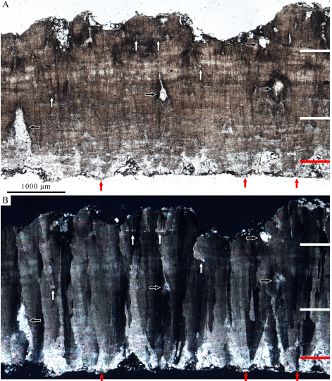
Once obtained the nephrite was cut into blanks (slices which could be further worked) using rasp-like saws made from sedimentary rock, which would have been drawn back and forth across the softer nephrite, probably with the addition of water and sand. These saws were small tools, designed to fit in the palm of the hand. Many had curved backs, which would have enabled them to be controlled by the index finger. Once the rock was cut into squared slices in this way it could then be ground to the desired thickness using a piece of rough sandstone. The corners of the squared slices could then be removed by sawing into the blanks from both sides, then snapping them off, to give a more rounded piece.

Once a near-round shape was achieved, the blank was further shaped by smoothing the edges with a piece of sandstone to achieve a circular disk. Examples of such disks have been found at Đầu Rằm with multiple grinding grooves, indicating that they were used to shape rings of different widths. This shaping of the outer surface of the ring was always completed before the inner core was drilled out, presumably because the rings were less delicate at this stage.

The inner part of the ring is theorised to have been drilled out by mounting the circular blank on a turntable which could be rotated with a wooden bow mechanism, then grinding the moving ring with a stone drill bit attached to a horizontal fixed arm. This would have enabled a circular grove to have been cut into the blank, with adjustment of the position of the fixed arm enabling different sized circles to be cut. The blank would have been worked by carving paired grooves on each side. A wooden bow drill has been found at the Dong Du site, and debitage indicating this modus operandi at Tràng Kênh, while a number of drill bits consistent with this method have been recovered at Đầu Rằm.

Finally, once the grooves on each side of the blank were deemed sufficiently deep, the core would have been removed by striking it with a hammerstone to form a ring. This last part of the operation appears to have been quite tricky, with a risk of breaking the thin ring in the process. At least one ring apparently broken at this stage has been found at Đầu Rằm, as well as ten hammerstones, with percussion marks on multiple facets, probably indicating they were used for a variety of tasks; one of these was notably small, and could have been easily held in one hand for precision tasks such as striking out the core of a ring.

This process would have left a sharp, uneven, flange around the inside of the ring, so the next task would have been to remove this by inserting a cylindrical grinder which could be used to smooth this inner surface by manual rotation. Four such cylindrical grinders have been found at Đầu Rằm, three of which appear to have been used at both ends. 

Finally, the ring would have been polished to a smooth surface using a dense, fine-grained stone polisher (one example of which has been found at Đầu Rằm), and then probably a piece organic material such as Bamboo, wood, or leather.

The chaîne opératoire of manufacture for nephrite rings at Đầu Rằm: (a) Initial raw material cutting and sawing; (b) grinding a preform to a desired thickness; (c) cutting a preform to an appropriate size; (d) removing corners; (e) grinding to a circular shape; (f) drilling out a core (from both sides); (g) using a ‘punch’ to remove a core; (h) grinding the inside of a ring; (i) grinding the exterior; (j) polishing to produce a surface gloss. Shaw et al. (2023).

Previous excavations at Đầu Rằm produced material from two phases of occupation, with the majority of the material coming from the younger Bronze Age Đông Sơn culture. However, Shaw et al.;s 2018 excavations found no trace of this younger material. Both dating evidence and the material recovered suggest that the earlier phase of occupation at Đầu Rằm was Neolithic, and the common style of pottery and nephrite working strongly indicates that the culture here was the same as the one at the nearby Đầu Rằm, Tràng Kênh, and Bồ Chuyến sites, with archaeologists referring to this common culture as the Tràng Kênh culture, as this site was discovered first. 

Radiometric dates obtained from both Tràng Kênh and Đầu Rằm suggest that this culture was active during the early-to-middle second millennium BC, although the results were not considered accurate enough for a more detailed chronology. Occupation at the Tràng Kênh site continued into the Bronze Age, which has been dated here to the end of the second millennium BC.

The artisans at Đầu Rằm used a standardised tool kit and methodology to manufacture rings, which would have required both a high degree of skill and a level of technical understanding which enabled the manufacturing and maintenance of the equipment needed for this process. This process also appears to have been used at Tràng Kênh, where evidence for a range of other manufacturing processes, not seem at Đầu Rằm has also been discovered. Items seen at Tràng Kênh but not Đầu Rằm include earrings with four protuberances, penannular earrings and T-sectioned bangles. T-sectioned bangles have also been found at sites in the upper Red River Valley associated with the Phùng Nguyên Neolithic culture, and at Mán Bạc in Ninh Bình Province, a site confidently dated to between 2000 and 1300 BC, indicating manufacture clearly pre-dating the onset of the local Bronze Age.

The difference between the wider range of manufactured items found at Tràng Kênh than Đầu Rằm poses questions about the nature of the two sites. It is possible that Tràng Kênh was simply larger than Đầu Rằm, and could therefore support a greater range of craftsmen, but it is also possible that some of the skills used at Tràng Kênh were effectively trade secrets which the people of Đầu Rằm did not possess.

Examples of the various artefacts, debitage and implements used in the production of nephrite rings at Đầu Rằm; (a) nephrite raw material, the black arrow indicates where attempts have been made to shape the piece; (b) sandstone saw (working edge at bottom); c. corner offcuts with saw lines and flanges along their edges; (d). and (e) external grinders; (f) polished drill bit; (g) inner cores of various sizes, note misalignment in the coring of the two smallest specimens on the right (arrow: internal flange); (h) one working end of an internal ring grinder of sandstone; (i) hard, fine-grained sandstone grinder; (j) almost completed ring. Shaw et al. (2023).

The wide area over which jewellery apparently manufactured at Tràng Kênh and Đầu Rằm have been found implies that these settlements were embedded in an extensive trade network. It has been suggested that the raw materials from which this jewellery was made was itself imported, which if true, would suggest that the location of the settlements was chosen for access to waterways, and therefore trade networks. 

Items made from nephrite have been found at more than 70 Neolithic Phùng Nguyên culture sites on the plains around the lower Red River. Some of these sites, such as Hồng Đa, show evidence of local manufacture of this jewellery, presumably from imported materials, but it is quite likely that many were importing finished jewellery from Tràng Kênh and Đầu Rằm. Pottery thought to have been manufactured in the lower Red River Valley has been found at both Tràng Kênh and Đầu Rằm, implying that this was another item traded between communities.

The Neolithic trade networks in nephrite jewellery and other goods were, nevertheless, quite restricted compared to the Iron Age trade networks which emerged in the region with goods being traded from Thailand and Cambodia to Taiwan and the Philippines. The Neolithic trade network appears to have extended at least as far south as Cồn Nền, a Bàu Tró culture site on the coast of Quảng Bình Province. This is consistent with other evidence, which suggests that by about 4000 years ago, two distinct and separate trade networks had emerged in northern and southern Vietnam.

Elsewhere, there appears to have been trade between Taiwan and southeast China during the Neolithic, where workshops appear to have made similar cylindrical beads, rings and penannular earrings at Fengtian in eastern Taiwan, around the Zhujiang Delta, and at Yunglong in Hong Kong. Some of the techniques used at these Chinese workshops resemble those used at Tràng Kênh and Đầu Rằm, possibly implying a both groups shared a common ancestry, possibly from the lower Yangtze region of central China, where Neolithic workshops are known from around 4000 BC onwards.

See also...

Follow Sciency Thoughts on Facebook.

Follow Sciency Thoughts on Twitter


Tuesday 28 November 2023

Six people believed to have died following landslide on Wrangell Island, Alaska.

Four people have now been confirmed dead and two remain missing following a landslide on Wrangell Island, Alaska, on Monday 20 November 2023. The landslide, which is described as having been 137 m wide, brought several hundred tons of waterlogged soil and timber down onto the Zimovia Highway, south of the town of Wrangell, blocking the road and destroying three homes, one of which was unoccupied. One of the occupants of the homes, Christina Florschutz, survived the event with minor injuries, though her husband, Otto Florschutz, is still missing, as is one of their neighbours, 12-year-old Derek Heller. Derek's sixteen-year-old sister, Mara, was found dead in the immediate aftermath of the event, while the bodies of his parents, Timothy Heller, 44, and Beth Heller, 36, were found the next day. The body of eleven-year-old Kara Heller was located on Saturday 25 November by Alaska State Troopers with the aid of rescue Dogs.

The aftermath of a landslide on Wrangell Island, Alaska, on 20 November 2023, which is believed to have killed six people. Alaska Department of Public Safety/AP.

The landslide came amid an early winter storm, which brought 50 mm of rain to the island in a few hours and caused damage along a wide stretch of the Southeast Alaskan coast, although no further fatalities. Landslides are a common problem after severe weather events, as excess pore water pressure can overcome cohesion in soil and sediments, allowing them to flow like liquids. Approximately 90% of all landslides are caused by heavy rainfall. 

Another landslide blocking part of the highway between Klawock and Craig on Prince of Wales Island, following a storm on 20 November 2023. Clarence Peele/Alaska Public Media.

Winter storms in Alaska are typically the remnants of Pacific tropical cyclones. These storms have become more hazardous in recent years due to the warming climate, which has both led to sea ice forming later, removing a protective barrier from coastal regions, and a combination of the ground freezing later and precipitation falling as rain rather than snow, which leads to more flooding and landslide events.

See also...

Follow Sciency Thoughts on Facebook.

Follow Sciency Thoughts on Twitter


Monday 27 November 2023

Iceberg A23a has begun to move.

An iceberg known as A23a, considered to currently be the largest in the world, with a surface area of about 4000 km² and a thickness of about 400 m, has begun to move, after remaining grounded within the Weddell Sea for several decades. The iceberg was one of a cluster that broke away from the Filchner Ice Shelf in November 1986, prompting the emergency evacuation of a Russian science station which was located on the breakaway part of the ice, but subsequently became grounded in the shallow waters of the Weddell Sea. The iceberg subsequently moved a short way in 2020, but again became grounded. It has now begun moving again, and appears likely to move out of the Weddell Sea and into the Antarctic Circumpolar Current, which will carry it west towards South Georgia and South Africa.

The current location of Iceberg A23a. Copernicus-Sentinal 3/BBC.

The increased rate of movement and break up of many ice sheets, which leads to the formation of icebergs, is thought to be directly connected to rising global temperatures. However, the movement of icebergs once they have formed is less well understood and it is unclear to what extent these events are climate driven. Icebergs from the Antarctic Peninsula and Ronne Ice Shelf typically become trapped in the Weddell Sea for many years, before migrating into the Antarctic Circumpolar Current. Icebergs in this, slightly warmer, current will tend to melt over time, but can drift a long way first, sometimes becoming stranded off South Georgia or even drifting into the shipping lanes around South Africa.

See also...

Follow Sciency Thoughts on Facebook.

Follow Sciency Thoughts on Twitter.


Anchonidium selvanum: A new species of Weevil from northern Portugal.

The Weevil genus Anchonidium currently contains three valid species, all of which are found in Western Europe. Several from Africa and the Caucasus region which were previously assigned to the genus are now considered to be erroneous, and some of these have been reassigned to other genera.

In a paper published in the journal Alpine Entomology on 24 October 2023, Christoph Germann of the Naturhistorisches Museum Basel and the Naturhistorisches Museum Bern, and Carlo Braunert of the Musée National d’Histoire Naturelle de Luxembourg, describe a new species of Anchonidium from northern Portugal. 

The new species is named Anchonidium selvanum, where 'selvanum' refers to the ancient native Oak-forests of Portugal, which are referred to in Portuguese as 'la selva', which is the environment in which the Weevils were found. These Weevils are 2.1-3.3 mm in length, excluding the rostrum (snout) and auburn in colour. Their dorsal surface is covered with large punctures arranged in lines which run lengthwise along the body, the ventral surface has similar punctures, but more randomly arranged.

Anchonidium selvanum. (1) Male. (2) Female. (3) Male underside. Germann & Braunert (2023).

The distribution of all four species of Anchonidium follow mountain chains and river valleys in Portugal. Anchonidium braunerti is found in the Serra de Monchique south of the Rio Tajo, at altitudes of about 890 m above sealevel, on the upper parts of mountains where heather and mosses dominate, but where Oak forests were found on the lower slopes in the past but are now gone. Anchonidium spathiferum is found in the Serra da Estrela at altitudes of about 1290 m above sealevel, again in an environment dominated by heather and mosses, above slopes that were once covered by Oak woodland. Both of these species are considered rare. Only Anchonidium unguiculare is more widely distributed being found in Oak forests from Morocco to southern England. Anchonidium selvanum is still relatively common within its environment, the ancient Oak woodlands of the Serra do Marão and Serra do Alvão, at altidudes of between 750 m and 1180 m above sealevel.

Records from Anchonidium sensu stricto in Western Europe. Anchonidium unguiculare (blue dots), Anchonidium braunerti (green dot), Anchonidium spathiferum (red dot) and Anchonidium selvanum (yellow dots). Germann & Braunert (2023).

The Oak woodlands in which Anchonidium selvanum is found are a relic of ancient woodlands which once covered much of the mountains of Portugal, and which today are threatened by over-extraction of timber, and replacement of the Oaks by plantations of straighter, faster growing species valued by the timber industry, such as Eucalyptus and Mimosa trees from Australia or the Aleppo Pine. Pinus halepensis. Monocultural stands of these trees create a very different environment to ancient Oak wooklands, which is not a usable habitat for species which evolved in those woodlands. Worse still, all of these trees are addapted to survive periodic forest fires, which clear rival trees (and the wildlife dependant on those trees) from the environments where they are found. Their introduction has led to an increased fire frequency in mountainous areas of Portugal, presenting an additional threat to its indigenous wildlife. For this reason, Germann and Braunert conclude that Anchonidium selvanum should be regarded as a threatened species, but also that it can serve as a useful indicator species for the health of the woodlands in which it is found.

(Top) Habitat at type locality of Anchonidium selvanum at Bobal, 880 m above sealevel, Serra do Alvão. A small remaining part of the ancient Oak forest with Mosses, Lichens and a deep leaf litter layer at ground where the new species lives in remarkable densities. (Bottom) Remains and replantation of Oak forest in the Serra do Marão close to Ansiães. A good example for small remains of the ancient forests where only few individuals of Anchonidium selvanum were found. Carlo Braunert in Germann  Braunert (2023).

See also...

Follow Sciency Thoughts on Facebook.

Follow Sciency Thoughts on Twitter.


Sunday 26 November 2023

Dinosaur eggs from the Late Cretaceous Moxia Formation of Jiangxi Province, China.

The Moxia Formation of southern Jiangxi Province in southeast China forms part of the Wuning Group redbeds, with a mixture of sandstones and conglomerates, thought to have been laid down in a pluvial fan environment (i.e. an environment in which sediments are laid down after being washed out of hills or uplands in periodic, rain driven floods). These beds have not been dated precisely, and are thought to be Late Cretaceous or Palaeogene in origin.

In a paper published in the journal Vertebrata PalAsiatica in October 2023, Zhou Ming-Xiao of the Institute of Vertebrate Paleontology and Paleoanthropology of the Chinese Academy of Sciences, and the University of the Chinese Academy of Sciences, Yan Yun of the Wuning County Museum, Qui Wen-Jiang of the Basic Geological Survey Institute of the Jiangxi Geological Survey and Exploration Institute, Fang Kai-Yong, also of the Institute of Vertebrate Paleontology and Paleoanthropology of the Chinese Academy of Sciences, Zhu Xu-Feng of the National Natural History Museum of China, Wang Qiang, again of the Institute of Vertebrate Paleontology and Paleoanthropology of the Chinese Academy of Sciences, and Wang Xiao-Lin, once again of the Institute of Vertebrate Paleontology and Paleoanthropology of the Chinese Academy of Sciences, the University of the Chinese Academy of Sciences, and of the Centre for Research and Education on Biological Evolution and Environment at Nanjing University, describe a clutch of Dinosaur eggs from the Moxia Formation, uncovered during construction work in the town of Luoping in Wuning County, southern Jiangxi Province, and the implications of this for the age of the deposits.

The clutch comprises three broken eggs, as well as seven impressions of similar shape, some of which contain fragments of eggshell. The eggs are almost spherical in shape, with the least crushed measuring 106 mm by 86 mm. They have a rough outer surface, weathered, and covered with sediment.

The incomplete clutch of eggs (WNCM-V1) from Wuning, Jiangxi, China. (A) Three broken eggs (No. 2, 3, 5) and seven prints with a few eggshell remnants, eggs were arranged tightly and irregularly; (B)–(D) Magnification figures of the egg, No. 2 (B), No. 3 (C) and No. 5 (D). Zhou et al. (2023).

Sections of eggshell were selected for microscopic sections were cleaned by ultrasonic and embedded in resin for examination under a polarising light microscope. This revealed that the shells were between 2.76 and 2.97 mm, although this is probably less than the original thickness, due to weathering. They have a two-layered structure, with an outer cone layer 0.22–0.32 mm thick (roughly 10% total thickness) and an inner columnar layer 2.38 to 2.72 mm in thickness, which is typical of Dinosaur eggs. The inner columnar layer can in turn be divided into inner, medial and outer zones. The inner zone is 0.78 to 0.92 mm thick, which corresponds to about a third of the eggshell thickness. Areas of secondary growth can be found in the mdial and outer layers. The whole thickness is penetrated by worm-like pores.

Microstructure of the eggs in radial section (S221008-1②) under ordinary light (A) and cross-polarized light (B). White lines show the boundaries between the inner, medial and outer zones. (A) the boundary between the cone layer and columnar layer (red line) is not clear, accretion lines distribute through the shell, pore canals (black arrows) are irregular and worm-like, and the secondary eggshell units (white arrows) grow in the medial zone and the outer zone. (B) The eggshell units show radial extinction through the nucleation centres (red arrows) to the outer surface, and secondary eggshell units (white arrows) show independent radial extinction. Zhou et al. (2023).

Based upon this morphology, the eggs are assigned to the ichnospecies Coralloidoolithus shizuiwanensis, which has previously been described from the Xixia and Xichuan localities in Henan Province, and the Shanggao locality in Jiangxi Province, although the new specimens are slightly thicker than those previously assigned to this species. Although the egg-layer for Coralloidoolithus shizuiwanensis is unknown, the eggs are clearly Dinosaurian in origin, establishing the Moxia Formation as a Late Cretaceous rather than a Palaeogene deposit.

See also...

Online courses in Palaeontology

Follow Sciency Thoughts on Facebook.

Follow Sciency Thoughts on Twitter.


Saturday 25 November 2023

A hoard of coins from the Indus Valley City of Mohenjo Daro.

The Indus Valley Civilization was a Bronze Age civilization in northern South Asia, contemporary with the Old Kingdom in Egypt and the Sumerian Civilization of Mesopotamia. Spread across what is now Afghanistan, Pakistan, and northwest India, the Indus Valley Civilization is generally considered to have built the first cities in South Asia, as well as a major centre of Bronze Age technological innovation, although its language has never been translated, so that much about the civilization remains a mystery. The largest of the cities constructed by the Indus Valley people was Mohenjo Daro, located in the  Larkana District of Sindh Province, Pakistan. Mohenjo Daro has founded around 2500 BC, and at its height had a population of about 40 000. It was abandoned in about 1700 BC, along with the other major cities of the Indus Valley Civilization, although why this happened remains as mysterious as many other things about the culture.

Ruins aof the city of Mohenjo Daro in Sindh, Pakistan. Saqib Qayyum/Wikimedia Commons.

On Wednesday 15 November 2023, a team of conservators working on the western side of Mohenjo Daro stupa uncovered a jar of copper coins, the first coins uncovered at the site since 1931, although it is unlikely that they date back to the Indus Valley Civilization, which is not known to have produced coins. The hoard unearthed in 1931 comprised 4348 copper coins dating from the Kushan Empire, which lasted from about 30 AD till its conquest by the Gupta Empire in 375 AD, although its coins would have remained in circulation somewhat longer. 

A pot of copper coins discovered at Mohenjo Daro in Sindh Province, Pakistan, on 15 November 2023. Saeed Memon/Dawn.

The coins together weigh about five and a half kilograms, and are currently fused together into a single amalgam. It is hoped that it will be possible both to separate them and clean them sufficiently to make out the inscriptions on their surfaces, although this is likely to take some time. It is planned that once prepared, they will be placed on display at the Mohenjo Daro Museum in Larkarna.

See also...

Follow Sciency Thoughts on Facebook.

Follow Sciency Thoughts on Twitter.


Sesamothamnus leistneri: A new species of Sesame Tree fromthe Kaokoveld Region of Namibia and Angola.

The Sesame Family, Pedaliaceae, contains eleven genera of shrubs and trees, including the True Sesames, Sesamum spp.. Eight of these genera are confined to Africa, where the family is thought to have originated, while one, Uncarina spp., if found only on Madagascar. Of the remaining two genera, Pedalium (which contains only a single species, Pedalium murex) is found across much of Africa and South and Southeast Asia as far east as Java, while Sesamum spp. has a near global distribution, although it is likely to have been introduced to many places by Humans, due to the use of its seeds as a food crop.

Phylogenetic studies of the Family Pedaliaceae have suggested that the basalmost genera is Sesamothamnus, the Sesame Trees or Sesame Bushes, a group found in arid areas of Africa, split into two groups with a bimodal distribution. The first group of species is found in East Africa, from Ethiopia and Somalia south into Kenya and Tanzania, and are large, tree forming plants, the second group has a Southern African distribution, being found in Angola, Namibia, Botswana, Zambia and Zimbabwe, and are smaller, shrubby plants, with a bulbus base from which a single, taperinc stem arises.

The most recent species of Sesamothamnus to have been described was Sesamothamnus lugardii in 1906, however, in 1957 the South African botanists Bernard de Winter and Otto Albrecht Leistner recorded seeing a tree-like species of Sesamothamnus while on an expedition to the Kaokoveld Region of northwestern Namibia, and in addition brought back sterile samples which were stored in the collections of the South African National Biodiversity Institute in Pretoria and the National Botanical Research Institute in Namibia, where they were tentatively identified as Sesamothamnus benguellensis, a shrub-like form found in Namibia and Angola. In 1966 the Namibian botanist Heinrich Johann Wilhelm (Willy) Giess collected fertile specimens of the tree, which were stored in the National Botanical Research Institute in Namibia under the name 'Sesamothamnus leistneranus' apparently in honour of Otto Albrecht Leistner, although he never published a description of this material.

In a paper published in the journal Phytotaxa on 14 November 2023, Wessel Swanepoel, an independent researcher from Windhoek and Abraham van Wyk, from the H.G.W.J. Schweickerdt Herbarium at the University of Pretoria, formally describe the Kaokoveld Sesame Tree as a new species.

The species is described as Sesamothamnus leistneri, rather than Sesamothamnus leistneranus, as this implies that it was discovered by Leistner, rather than simply named in his honour. Wessel Swanepoel and first observed an unfamiliar Sesame Tree while visiting the Kaokoveld in 1990, although at that time the tree was not in flower or fruit, making identification very hard. In 2005 Swanepoel and van Wyk observed another Sesame Tree in the Otjitanda area of the Kaokoveld. This time the tree was producing both flowers and fruit, and samples were taken which enabled it to be compared to the material previously collected by de Winter, Leistner, and Giess.

Sesamothamnus leistneri, habitat and habit. (A) Multi-stemmed tree with distinct browse line caused by domestic stock. (B) & (C) Trees showing typical upright habit and relatively dense green foliage during the rainy season. Swanepoel and van Wyk (2023).

Sesamothamnus leistneri is a single or (more-commonly) multi-trunked succulent tree, reaching about 8 m in height. Branches are formed high on these trunks, and covered with sharp spines up to 30 mm in length, formed from modified petioles (leaf stalks). The bark of the tree is creamy yellow, and peels away from the trunks in papery strips. The trees are deciduous, producing waxy green leaves 40-70 mm in length and 15-40 mm. Flowers are produced from January to June and are large and cylindrical, reaching 150 mm in length and 55 mm in width, white or cream on the outside and bright yellow on the interior. Flowers of this type are likely to be pollenated by Long-tongued Hawkmoths, as is the case with other members of the genus. The fruit, produced from February onwards is a green-to-yellow rigid woody capsule, 65-90 mm in length and 25-32 mm in width, which splits open during the dry season releasing a large number of small, winged seeds.

Sesamothamnus leistneri, habitat and habit. (A) Typical single-stemmed tree. (B) Tree with foliage starting to turn yellow in autumn. (C) Leafless tree during the dry season (winter), with persistent dehisced fruit. Swanepoel & van Wyk (2023).

Sesamothamnus leistneri was found growing in mountainous regions on both sides of the Kunene River, which forms the border between Namibia and Angola. In Namibia it was found from the Ehomba Mountain and Zebra Mountains in the east throughout the Baynes Mountains to the Otjihipa Mountains in the west, and south as far as Sesfontein. In Angola Sesamothamnus leistneri was observed near the summit of Serra Tchamalindi in the Iona National Park, and is thought likely to be fairly widespread.

Sesamothamnus leistneri, vegetative morphology. (A) Single-stemmed tree showing fluted trunk. (B) Bark peeling in papery pieces. (C) Long shoot with leaves clustered on lateral short shoots. (D) Mature leaves showing green colour and glossy upper surface. (E) Long shoot with spines derived from petioles; one dried leaf blade still attached. Swanepoel & van Wyk (2023).

Sesamothamnus leistneri grows on rocky mountain and valley slopes, in kloofs (gorges), less often on plateaus and at the base of hills, in Colophospermum-Commiphora woodland at elevations of 1000–1600 m, Between 83 and 220 km from the Atlantic Ocean. Rainfall in this area is typically 100-300 mm per year. This area is sparsely populated by Humans, and the tree does not appear to be utilised by Humans in any way, though it is browsed by livestock during periods of drought. As such Swanepoel and van Wyk assess that it should be classified as being of Least Concern under the terms of the International Union for the Conservation of Nature's Red List of Threatened Species.

Sesamothamnus leistneri, flower morphology. (A) Inflorescence showing one open flower, several flowers in different stages of development, and persistent styles (whitish, tipping blackish ovaries) of faded flowers following shedding of the corolla. (B) Flowers, open and in bud; note both stamens and stigma positioned in mouth of the corolla tube, also the lack of a spur at the base of the tube. (C) Flower showing style with bilobed stigma exserted about 10 mm from the mouth of the corolla tube. (D) Distal part of corolla tube opened out to show the yellow inner surface of the tube, white filaments, and anthers positioned at the level of the corolla mouth. Swanepoel & van Wyk (2023). 

The tree-like general habit of Sesamothamnus leistneri suggests that it is more closely related to the Sesame Trees of northern East Africa than the shrubby forms of Southern Africa. This is not altogether surprising, as while these areas are now separated by humid tropical forests where these Plants are unlikely to be able to survive, it is thought that the two zones would have been connected by bands of arid land several times during the Pleistocene glacial phases, when the climate of Africa would have been cooler and dryer.

Sesamothamnus leistneri, fruit morphology. (A) Two almost mature fruit and a dehisced one. (B) Old dehisced fruit persist for some time on trees. Swanepoel & van Wyk (2023).

See also...


Follow Sciency Thoughts on Facebook.

Follow Sciency Thoughts on Twitter.