Thursday 29 September 2016

Psora altotibetica: a new species of high-altitude Lichen from Mount Everest and the High Himalayas of Nepal & Tibet.

Lichens are hybrid symbiotic organisms, with a 'body' comprised of Fungal hyphae within which can be found cells of an Algal symbiont, and (it has recently been discovered) a third, Bacterial component that somehow facilitates the symbiosis between the other two partners. This unique symbiosis enables lichens to survive in a wide variety of habitats found inhospitable by other organisms, including hot and cold deserts, mountaintops and the high tidal zone on exposed rocky shores, as well as man-made surfaces such as brick and concrete.

In a paper published in the journal MycoKeys on 13 May 2016, Einar Timdal of the Natural History Museum of the University of Oslo, WalterObermayer of the Institut für Pflanzenwissenschaften at Karl-Franzens-Universität Graz, and Mika Bendiksby of the UniversityMuseum at the Norwegian University of Science and Technology, describe a new species of Lichen from the High Himalayas of Nepal and Tibet.

The new species is placed in the genus Psora, which contains about 30 species found on rock and soil from arid areas from the Arctic to the subtropics, and given the specific name altotibetica, from 'altitude' and 'Tibet'. The species was first identified from a preserved specimen at the Herbarium of the Institut für Pflanzenwissenschaften at Karl-Franzens-Universität Graz, collected by Austrian lichenologist Josef Poelt (1924-1995) in 1962 from near the Khumbu Glacier in Nepal, south of Mt Everest, then again in some specimens collected by Torstein Engelskjøn of the Tromsø Museum from the Rongbuk Valley in Tibet, north of Mt Everest, during a joint Chinese-Norwegian scientific expedition in 1993, and subsequently in a number of other specimens collected at altitudes between 4230 and 5000 m in Tibet and stored in the Herbarium of the Institut für Pflanzenwissenschaften.
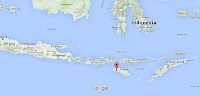
Psora altotibetica, known distribution. Open circle = holotype locality. Timdal et al. (2016).

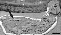
Psora altotibetica is a white or off-white encrusting Lichen with black apothacia (cup-shaped fruiting-body that produces spores). It's upper tissues were found to contain crystals of gyrophoric acid and calcium oxalate. A genetic analysis suggests it is closely related to Psora tenuifolia, another Tibetan species, which has been recorded at altitudes of between 2610 and 4525 m.
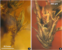
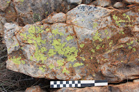
 Psora altotibetica growing on rock. Scale bar is 1 mm. Timdal et al. (2016).

See also...

http://sciencythoughts.blogspot.co.uk/2016/09/evidence-of-lichen-growth-on-bones-of.htmlEvidence of Lichen growth on the bones of Homo naledi.                                                    In 2013 scientists in South Africa described the discovery of a remarkable new Hominin species in the Dinaledi Cave System in Gauteng State, South Africa (part of the Maropeng Cradle of Humankind...
http://sciencythoughts.blogspot.co.uk/2014/11/a-new-species-of-lichen-infecting.htmlA new species of Lichen-infecting parasitic Fungus from Scandinavia.                                      Lichens are symbiotic organisms, each consisting of a Fungus and an Alga, the Fungus obtaining nutrients from the substrate (surface upon which the Lichen sits), while the Alga produces carbohydrates through photosynthesis. They the Fungi and Algae involved...
Follow Sciency Thoughts on Facebook.

Thousands evacuated following eruption on Mount Rinjani, Lombok.

The Pusat Vulkanologi dan Mitigasi Bencana Geologi (which monitors volcanoes and other geohazards in Indonesia) has set up a three kilometer exclusion zone around Mount Rinjani,  an active volcano on northern Lombok island, on Tuesday 27 September 2016. The eruption came without warning, and produced an ash column two kilometers in height from the Gunung Barujari crater, which first erupted in 1994. At the time of the eruption over a thousand tourists were in the Mount Rinjani National Park, which surrounds the volcano, including 639 foreign nationals. Initial reports suggested that some of these were missing and may have been trapped by the eruption, but all have now been found and evacuated, including some who reportedly initially sought to avoid local authorities in order to observe and document the eruption.

The 27 September 2016 eruption on Mount Rinjani. Antara Foto/Reuters.

The Indo-Australian Plate, which underlies the Indian Ocean to the south of Java, Bali and Lombok, is being subducted beneath the Sunda Plate, a breakaway part of the Eurasian Plate which underlies the islands and neighbouring Sumatra, along the Sunda Trench, passing under the islands, where friction between the two plates can cause Earthquakes. As the Indo-Australian Plate sinks further into the Earth it is partially melted and some of the melted material rises through the overlying Sunda Plate as magma, fuelling the volcanoes of Java and neighbouring islands.

The approximate location of Mount Rinjani. Google Maps.

Subduction along the Sunda Trench beneath Java, Bali and Lombok. Earth Observatory of Singapore.

See also...
 
http://sciencythoughts.blogspot.co.uk/2016/06/flooding-and-landslides-kill-forty.htmlFlooding and landslides kill forty seven in Central Java.                                               Forty seven people have been confirmed dead and another fifteen are missing after a series of landslides and flash floods in Central Java, Indonesia, this week. Landslides are a common problem after severe...
http://sciencythoughts.blogspot.co.uk/2016/02/magnitude-63-earthquake-beneath-palau.htmlMagnitude 6.3 Earthquake beneath Palau Sumba, Indonesia.                               The United States Geological Survey recorded a Magnitude 6.3 Earthquake at a depth of 28 km...
http://sciencythoughts.blogspot.co.uk/2015/11/landslide-believed-to-have-killed-one.htmlLandslide believed to have killed one person in West Java, Indonesia.                              One person is missing and believed to be dead following a landslide that hit the Karangmukti...
Follow Sciency Thoughts on Facebook.

Wednesday 28 September 2016

Magnitude 5.2 Earthquake off the northwest coast of Rhodes.

The United States Geological Survey recorded a Magnitude 5.2 Earthquake at a depth of 83.3 km, about 30 km to the northwest off the island of Rhodes slightly before midnight local time (slightly before 9.00 pm GMT) on Monday 27 September 2016. No damage or injuries have been reported following this event, but people have reported feeling the event from Rhodes and neighbouring islands, as well as much of the Anatolian (Turkish) mainland and as far away as Peleponesia in Greece.

The approximate location of the 23 September 2016 Rhodes Earthquake. Google.

The island of Rhodes lies on the boundary between the Anatolian Plate, to the north, the Aegean Sea Plate (underlying the Peloponnese, Attica, The Cyclades Islands, Crete, the Dodecanese Islands and Turkey to the southeast of the Taurus Mountains) to the west and the African Plate to the south. Northern Greece and the north coast of Turkey lie on the Eurasian Plate. Both countries are highly prone to earthquakes because of this.

To the east the Arabian Plate  is being pushed north and west by the movement of the African Plate, further to the south. This leads to a zone of tectonic activity within the province, as the Arabian and Anatolian plates are pushed together, along the East Anatolian Fault, and past one-another, along the Dead Sea Transform.

This movement also leads to a zone of faulting along the northern part of Turkey, the North Anatolian Fault Zone, as the Anatolian Plate is pushed past the Eurasian Plate, which underlies the Black Sea and Crimean Peninsula  (transform faulting). This is not a simple process, as the two plates constantly stick together, then break apart as the pressure builds up, leading to Earthquakes, which can be some distance from the actual fault zone.

The Aegean Sea Plate is moving southwest with regard to the Eurasian and Anatolian Plates, and being subducted beneath the African Plate to the south. Its margin with the Eurasian Plate is a divergent and a transform margin at different points. This is not a smooth process, with rocks tending to stick together, then being forced to move as the pressure builds up, typically in stops and starts that lead to Earthquakes.

 Simplified map of the plate movements of the eastern Mediterranean. Univeriteit Utrecht.

Witness accounts of Earthquakes can help geologists to understand these events, and the structures that cause them. The international non-profit organisation Earthquake Report is interested in hearing from people who may have felt this event; if you felt this quake then you can report it to Earthquake Report here.
See also...
http://sciencythoughts.blogspot.co.uk/2014/06/magnitude-45-earthquake-off-coast-of.htmlMagnitude 4.5 Earthquake off the coast of Hatay Province, southeast Turkey.               The United States Geological Survey recorded a Magnitude 4.5 Earthquake at a depth of 10 km, about 8 km offshore of the city of İskenderun in Hatay...
http://sciencythoughts.blogspot.co.uk/2014/05/magnitude-69-earthquake-beneath-north.htmlMagnitude 6.9 Earthquake beneath the north Aegean Sea.                                                 The United States Geological Survey recorded a Magnitude 6.9 Earthquake at a depth of 10 km beneath the north Aegean Sea, close to the...
http://sciencythoughts.blogspot.co.uk/2013/10/magnitude-64-earthquake-off-west-coast.htmlMagnitude 6.4 Earthquake off the west coast of Crete.                                                       The United States Geological Survey recorded a Magnitude 6.4 Earthquake at a depth of 36.2 km roughly 30 km off the west coast of Crete...
Follow Sciency Thoughts on Facebook.
 

Tuesday 27 September 2016

Brachycoraebus aeneus & Metasambus circularis: Two new species of Jewel Beetles from Singapore and Sumatra.

The Tribe Coraebini is the largest subgroup within the Buprestidae (Jewel Beetles). These are small Beetles found within the forest canopy in both temperate and tropical regions, though both their biology and true diversity is poorly understood, due to the inaccessible nature of their prefered habitats.

In a paper published in the Raffles Bulletin of Zoology on 31 August 2016, Loong-Fah Cheong of the Lee Kong Chian Natural History Museum, describes two new Beetles from the Tribe Coraebini, both of which were found in Singapore, and one also on Sumatra.

The first new Beetle described is placed in the genus Brachycoraebus and given the specific name aeneus, in reference to its brassy colouration. This species is described from two specimens, a female collected from the Nee Soon Swamp Forest on Singapore in September 2013, and a male collected from an unknown location on the island in April 1923. These are small Beetles, the male measuring 3.6 mm in length and 1.5 mm in width and the female 4.2 mm in length and 1.9 mm in width. They are dark brown in colour, and covered with short golden hairs, which gives them a brassy appearance; their undersides are black.

Brachycoraebus aeneus, female specimen in life. Loong-Fah Cheong (2016).

The second new species described is placed in the genus Metasambus, and given the specific name circularis, in reference to the circular pattern on the elytra (wing case) of the Beetles. The species is described from seven specimens, two from the Riffle Range Forest of Singapore and five from an unknown location on Sumatra. These are also small Beetles, measuring 3.8 mm in length and 1.3 mm in width, and are black in colour with a purplish tinge, and a covering of white hair on the elytra which forms two distinct bands, each with a circular pattern on each wing-case.

 Metasambus circularis, male specimen. Loong-Fah Cheong (2016).

 See also...

http://sciencythoughts.blogspot.co.uk/2014/01/two-new-species-of-jewel-beetle-from.htmlTwo new species of Jewel Beetle from Central America.                                                      Jewel Beetles (Buprestidae) are wood-boring Insects with distinctive bright, metallic elytra...
http://sciencythoughts.blogspot.co.uk/2012/12/six-new-species-of-jewel-beetle-from.htmlSix new species of Jewel Beetle from Southeast Asia.                                             Jewel Beetles (Buprestidae) are wood-boring Insects with distinctive bright, metallic elytra...
Follow Sciency Thoughts on Facebook.
 

Didymodon hengduanensis: A new species of Moss from the Hengduan Mountains of southwest China.

The Hengduan Mountains form the southeastern tip of the Himalayas, stretching from eastern Sichuan Province through northern Yunnan and southeaster Tibet into southern Myanmar. The range comprises a series of parallel north-south mountain ridges with south-flowing rivers between. The area is considered to be one of the world's biodiversity hotspots, with sharp divisions in flora and fauna both between the valleys of the range and at different altitudes on the mountains, leading to a very high number of endemic species.

In a paper published in the journal Phytotaxa on 21 September 2016, Juan Jiménez of the Departamento de Biología Vegetal (Botánica) at the Universidad de Murcia, David Long of the Department of Botany at the California Academy of Sciences, James Shevok of the Royal Botanical Garden iEdinburgh and Juan Guerra, also of the Departamento de Biología Vegetal (Botánica) at the Universidad de Murcia, describe a new species of Moss from the Hengduan Mountains of Sichuan and Yunnan provinces.

The new Moss is placed in the widespread and specious genus Didymodon, and given the specific name hengduanensis, meaning 'from Henduan'. The species is described from five specimens from Lushu, Heqing, Gongshan, and Shangri-la counties in Yunnan Province and Yajiang County in Sichuan Province, collected by Davd Long and James Shevock during a series of joint expeditions with the Chinese Academy of Sciences. The moss grows in dense tufts reaching 3.7 cm in height, and yellowish green in colour. It is distinguished from other Mosses in the genus Didymodon by its long, pointed leaves and by the presence of a leaf margin, made up of cells distinct from those of the rest of the leaf.

Habit of Didymodon hengduanensis in dry state. Jiménez et al. (2016).

See also...

http://sciencythoughts.blogspot.co.uk/2016/06/didymodon-novae-zelandiae-new-species.htmlDidymodon novae-zelandiae: A new species of Moss from Manukau Harbour, New Zealand.                                                    Mosses are among the simplest and most ancient groups of plants. They lack flowers, seeds and roots, and only have very simple vascular systems...
http://sciencythoughts.blogspot.co.uk/2014/07/mosses-from-late-eocene-rovno-amber.htmlMosses from Late Eocene Rovno Amber. Mosses are thought to be among the most ancient of plant groups, and still make up a significant proportion of all plant communities. They are an ancient group, considerably predating vascular plants such as Ferns and Seed Plants, but they have a poor fossil record, largely due to their lack of...
http://sciencythoughts.blogspot.co.uk/2012/12/two-new-species-of-moss-from-permian-of.htmlTwo new species of Moss from the Permian of Brazil.                                                         Mosses (Bryophytes) are simple plants which lack vascular systems to pump water and nutrients from a root system, instead relying on what they can absorb through their leaves, and generally only reaching a few cm in height. This means that they...
 Follow Sciency Thoughts on Facebook.

Monday 26 September 2016

Cave-in at Polish copper-mine kills two.

Two miners have died and another was seriously injured following a cave-in at the Polkowice-Sieroszowice Copper Mine in Lower Silesia Province, Poland, on Friday 23 September 2016. The cause of the incident at the KGHM Polska Miedz SA owned mine is not yet clear.

Workers at the Polkowice-Sieroszowice Copper Mine. KGHM Polska Miedz SA.

The Polkowice-Sieroszowice Mine targets metal-rich shale (clay) beds within a carbonate (limestone) dominated rock sequence. These shale beds are rich in copper and silver, being roughly 2.3% copper and 62 parts per million silver (this sounds like a small amount of silver, but it makes the Polkowice-Sieroszowice Mine the world's second most productive silver mine in the world). The mine also produced significant amounts of rock salt from different desposits. The mine has been operating since 1962, but questions have been raised about the safety of the mine this year following a series of incidents and fatalities, with this week's accident brining the number of deaths at this mine to six this year.

See also...

http://sciencythoughts.blogspot.co.uk/2014/06/rescue-operation-ongoing-at-riesending.htmlRescue operation ongoing at Riesending Cave, near Berchtesgaden in the German Alps.                                                               A rescue operation is underway at Riesending Cave, near...
http://sciencythoughts.blogspot.co.uk/2013/10/three-workers-killed-by-gas-at-german.htmlThree workers killed by gas at German potash mine.                                               Three workers have died and another four needed to be rescued after a controlled explosion at a Kali & Salz (K+S) GmbH operated mine near Unterbreizbach in Thuringia at about 1.10 pm local time (about 11.10 am GMT) on Tuesday 1 October 2013, which released an undetected pocket of gas, creating a larger...

http://sciencythoughts.blogspot.co.uk/2013/03/polish-miners-rescued-after-earthquake.htmlPolish miners rescued after Earthquake.      On Tuesday 19 March 2013, slightly before 9.10 pm GMT (slightly before 10.10 pm local time) the Lower Silesia Region of southwest Poland was struck by a magnitude 4.7 Earthquake at a depth of 3.7 km, close to the town of Lubin, which was felt as far away... 
Follow Sciency Thoughts on Facebook.
 

Sunday 25 September 2016

Burundi Earthquake causes at least two fatalities.

The United States Geological Survey recorded a Magnitude 4.8 Earthquake at a depth of 10 km, in the northwest of Cibitoke Province of northwestern Burundi, close to the border with Rwanda, slightly before 6.10 pm local time (slightly before 4.10 pm GMT) on Friday 23  September 2016. There have been at least two fatalities following this event, and at least five injuries, as well as a large number of building collapses; the damage has been more severe than would be expected for an event of this size, largely because it occurred in an area where Earthquakes this large are rare and few if any buildings are Earthquake proofed. People have reported feeling the event across the eastern Democratic Republic of Congo, as well as most of Rwanda and Burundi, though the fatalities and injuries have all been reported in the Congo.

Damage following the 23 September 2016 Cibitoke Province Earthquake. BBC/Earthquake Report.

Burundi lies within the the of the Great Rift Valley, which is slowly splitting the African Plate in two along a line from the Red Sea through Ethiopia, and which includes the great lakes and volcanoes of east-central Africa. This has the potential to open into a new ocean over the next few tens of millions of years, splitting Africa into two new, smaller, continents; Nubia to the west and Somalia to the east.

  Movement on the African Rift Valley, with associated volcanoes. Rob Gamesby/Cool Geography.

Witness accounts of Earthquakes can help geologists to understand these events, and the structures that cause them. The international non-profit organisation Earthquake Report is interested in hearing from people who may have felt this event; if you felt this quake then you can report it to Earthquake Report here.
 The approximate location of the 23 September 2016 Cibitoke Earthquake. Google.
See also...
http://sciencythoughts.blogspot.co.uk/2016/09/fourteen-dead-after-earthquake-in.htmlFourteen dead after Earthquake in northwest Tanzania.                                                      The United States Geological Survey recorded a Magnitude 5.9 Earthquake at a depth of 40 km, roughly 22 km to the northeast of Nsunga in the Kagera...
http://sciencythoughts.blogspot.co.uk/2016/03/eruptions-from-new-vent-on-mount.htmlEruptions from new vent on Mount Nyiragongo, Democratic Republic of Congo. The Observatoire Volcanologique de Goma has raised concerns about the possibility of a major eruptive episode on Mount Nyiragongo in the Virungu Mountiains of the North Kivu Province in eastern...
http://sciencythoughts.blogspot.co.uk/2015/08/magnitude-55-earthquake-on-western.htmlMagnitude 5.5 Earthquake on the western shore of Lake Kivu.                             The United States Geological Survey Recorded a Magnitude 5.5. Earthquake at a depth of 10 km beneath the western shore of Lake Kivu, which... 
Follow Sciency Thoughts on Facebook. 

Thursday 22 September 2016

Previously unidentified Burnetiamorph specimens from the Permian Karoo Basin of South Africa,

The Burnetiamorphs are a poorly understood group of Permian Theraspids (Theraspids are the group which gave rise to and and include the living Mammals, though Burnetiamorphs are not thought to be particularly closely related to the earliest Mammals or their direct ancestors) known from Southern and East Africa and Russia. The group has a somewhat limited fossil record; by the end of the twentieth century only two species had been described, one from South Africa and one from Russia, though since then the number has risen to ten species. The most commonly preserved part of Burnetiamorphs is a heavy bone boss, made up of the fused and thickened bones of the occipital region and the upper part of the braincase, though it is often hard to identify the different bone components in these dense structures, making them of limited use for understanding relationships within the group.
  
In a paper published in the journal Palaeontologia Africana on 23 March 2016, Christian Kammerer of the Museum für Naturkunde at the Leibniz-Institut für Evolutions- und Biodiversitätsforschung and the Evolutionary Studies Institute at the University of theWitwatersrand, records two previously undescribed Burnetiamorph specimens from museum collections. Both specimens originate in the Karoo Basin of South Africa, and both are considered by Kammerer to be too fragmentary to assign to a species, but they nevertheless provide insights into this little known group.

The first specimen described, TM 4305, comes from the collection of the Ditsong National Museum of Natural History in Pretoria. It comprises a weathered and only particularly prepared skull fragment, including the interorbital region, temporal region and dorsal occiput. Any details of where or when, or by whom this specimen was collected appear to have been lost, though it does have a label attached, identifying it as coming from the Tapinocephalus Assemblage Zone, making it Middle Permian in age.

TM 4305 in (A) right lateral, (B) left lateral, (C) anterior, (D) ventral and (E) posterior views. nb, Nasal boss; or, orbit; po, postorbital bar; sb, supraorbital boss; sp, sphenoid element; tf, temporal fenestra. Kammerer (2016).

The second specimen described, NHMUK R871, comes from the collection of the Natural History Museum in London. This specimen comes with more detailed location information, having been collected by palaeontologist Thomas Bain (1797-1864) at a site in Tafelberg, Beaufort West, which produced a number of other, more complete and more studied, vertebrate fossils, all of which were assigned to the genus Tropidostoma; the location is therefore considered to be part of the Tropidostoma Assemblage Zone, making it Late Permian in age.

This specimen comprises a fragment of skull roof preserving the interorbital region and temporal roof to the anterior edge of the pineal foramen. It was originally identified as a 'Theriodont? Reptile' and subsequently as a 'Deinocephalian', but both a Deinocephalian in the Tropidostoma Assemblage Zone and a Theriodont with the extent of bone fusion and thickening seen in the specimen are highly unlikely. The pattern of bone fusion is, however, consistent with a Burnetiamorph, and Kammerer feels confident in assigning the specimen to this group.

NHMUK R871 in (A) right lateral, (B) left lateral, (C) anterior and (D) posterior views. mb, Median boss; sb, supraorbital boss. Kammerer (2016).

See also...

http://sciencythoughts.blogspot.co.uk/2015/03/dinocephalian-therapsids-from-middle.htmlDinocephalian Therapsids from the Middle Permian of the Karoo Basin, South Africa.       The Dinocephalians were a group of mostly large, herbivorous Therapsids (the group that also includes Dicnodonts and Mammals) known from the Middle Permian of Russia, Central Asia, China...
http://sciencythoughts.blogspot.co.uk/2014/04/scavenging-on-body-of-dicynodont.htmlScavenging on the body of a Dicynodont Therapsid in the Late Permian of the Karoo Basin.                                                     Therapsids were a group of Synapsid Amniotes (the group of terrestrial vertebrates that include the...
http://sciencythoughts.blogspot.co.uk/2013/07/strange-bedfellows-in-early-triassic.htmlStrange bedfellows in an Early Triassic burrow from the Karoo.                                              The Early Triassic Karoo Basin contain numerous preserved burrows of small Tetrapods, interpreted as adaptations to a harsh, seasonally dry, climate...
Follow Sciency Thoughts on Facebook.

Landslide kills four in Gorkha District, Nepal.

Four people have been confirmed dead and seventeen other have been injured in a landslide in Gorkha District, Nepal, on Thursday 22 September 2016. The incident occured on the Manaslu Trekking Route, a popular tourist destination in Nepal, and one of the dead and eleven of the injured have been identified as Spanish nationas holidaying in the area, while one of the other fatalities has been identified as a local tour guide. Efforts are roportedly underway to evacuate the injured to a hospital in Kathmandu.

A victim of the 22 September 2016 Gorkha District landslide. AP.

The incident has been blamed on torrential rainfall that has fallen across the country in the last few days. Landslides are common during the monsoon season in Nepal, which lasts from May to September, with  the highest rainfall occurring in July. Landslides are a common problem after severe weather events, as excess pore water pressure can overcome cohesion in soil and sediments, allowing them to flow like liquids. Approximately 90% of all landslides are caused by heavy rainfall. Landslides are a problem in Nepal every monsoon season, though this year has seen a particularly high instance of sich events, possibly due to the aftereffects of the April 2015 Nepal Earthquake, which disrupted rock formations across the country.

Monsoons are tropical sea breezes triggered by heating of the land during the warmer part of the year (summer). Both the land and sea are warmed by the Sun, but the land has a lower ability to absorb heat, radiating it back so that the air above landmasses becomes significantly warmer than that over the sea, causing the air above the land to rise and drawing in water from over the sea; since this has also been warmed it carries a high evaporated water content, and brings with it heavy rainfall. In the tropical dry season the situation is reversed, as the air over the land cools more rapidly with the seasons, leading to warmer air over the sea, and thus breezes moving from the shore to the sea (where air is rising more rapidly) and a drying of the climate. This situation is particularly intense in South Asia, due to the presence of the Himalayas. High mountain ranges tend to force winds hitting them upwards, which amplifies the South Asian Summer Monsoon, with higher winds leading to more upward air movement, thus drawing in further air from the sea. 

Diagrammatic representation of wind and rainfall patterns in a tropical monsoon climate. Geosciences/University of Arizona.

See also...

http://sciencythoughts.blogspot.co.uk/2016/09/landslides-kill-at-least-eleven-people.htmlLandslides kill at least eleven people in Nepal.                                                            At series of landslides have killed at least eleven people in Nepal in the first few days of...
http://sciencythoughts.blogspot.co.uk/2015/11/multiple-deaths-after-landslide-pushes.htmlMultiple deaths after landslide pushes bus into ravine in Rasuwa District, Nepal. Thirty-four people are known to have died, twenty five people are being treated in hospitals and many more people are missing after a landslide swept a bus into ravine in Rasuwa District, Nepal, on Tuesday...
http://sciencythoughts.blogspot.co.uk/2015/08/landslide-hits-bus-in-palpa-district.htmlLandslide hits bus in Palpa District, Nepal, killing at least three.                                     Three people have been confirmed dead after a landslide hit a bus traveling from Palpa to Butwal on the Siddhartha Highway near Siddhababa...
Follow Sciency Thoughts on Facebook.

The September Equinox.

The September Equinox will falls on 22 September this year (2016), when the day and night will be of equal length in both of the Earth's hemispheres. The Earth spins on its axis at an angle to the plain of the Solar System. This means that the poles of the Earth do not remain at 90° to the Sun, but rather the northern pole is tilted towards the Sun for six months of the year (the northern summer), and the southern pole for the other six months (the southern summer). This means that twice a year neither pole is inclined towards the Sun, on days known as the equinoxes. 

 Simplified diagram showing the tilt of the Earth throughout the year. Not to scale. The Human Adventures in Space Exploration.

The equinoxes fall each year in March and September, with the March Equinox being the Spring (or Vernal) Equinox in the Northern Hemisphere and the Autumn Equinox in the Southern Hemisphere, while the September Equinox is the Autumn Equinox in the Northern Hemisphere and the Spring Equinox in the Southern Hemisphere. On these two days the day and night are both exactly twelve hours long at every point on the planet, the only days on which this happens.

See also...

http://sciencythoughts.blogspot.co.uk/2016/07/earth-reaches-its-aphelion.htmlEarth reaches its aphelion.                             The Earth reached its aphelion, the furthest point in its orbit from the Sun, a distance of 152 111 120 km, at 4.24 pm GMT on Monday 4 July 2016. The Earth's orbit is slightly eccentric and slightly variable, leading to the distance between the Earth and the...
http://sciencythoughts.blogspot.co.uk/2016/06/the-june-solstice.htmlThe June Solstice.                                         The June (or Northern) Solstice falls on Monday 20 June in 2016, the day on which the Sun rises highest in the sky and the longest day of the year in the Northern Hemisphere (where it is the...

http://sciencythoughts.blogspot.co.uk/2016/03/march-equinox-2016.htmlMarch Equinox, 2016.                                  The March Equinox fell on 20 March this year. The Earth spins on its...

Follow Sciency Thoughts on Facebook.

Wednesday 21 September 2016

Airports closed after eruptions on Mount Turrialba.

Several airports in Costa Rica were forced to close after a pair of eruptions on Mount Turrialba, a stratovolcano (cone shaped volcano made up of layers of ash and lava) in the central part of the country, Monday 19 September 2016. The first eruption occured at about dawn, the second at about noon, this latter event producing an ash column over four kilometers high, and causing ashfalls in the city of Cartago. A third eruption occured on Tuesday 20 September.

Eruption on Mount Turrialba on Monday 19 September 2016. Red Sismológica Nacional/Universidad de Costa Rica.

Volcanic ash is extremely hazardous to aircraft in a number of ways. At its most obvious it is opaque, both visually and to radar. Then it is abrasive, ash particles physically scour aircraft, damaging components and frosting windows. However the ash is most dangerous when it is sucked into jet engines, here the high temperatures can melt the tiny silica particles, forming volcanic glass which then clogs engine. When this happens the only hope the aircraft has is to dive sharply, in the hope that cold air passing through the engine during the descent will cause the glass to shatter, allowing the engine to be restarted.

 Residents of Cartago during an ashfall event on Monday 19 September 2016. AFP.

Turrialba forms part of the Cordillera Central, a range of volcanic mountains running through central Costa Rica and forming part of the Central American Arc. These volcanoes are fueled by the subduction of the Cocos Plate, which underlies part of the east Pacific Ocean, beneath the Caribbean Plate, on which Central America lies, along the Middle American Trench, which lies off the south coast of the country. As the Cocos Plate is subducted it is gradually melted by the heat and pressure of the Earth's interior, with some more volatile minerals rising through the overlying Caribbean Plate as volcanic magma.

  Diagram showing the passage of the Cocos Plate beneath Costa Rica (not to scale). Carleton College.

See also...

http://sciencythoughts.blogspot.co.uk/2016/05/exclusion-zone-established-around-mount.htmlExclusion zone established around Mount Turriabla after a series of eruptions on Sunday 1 May 2016.                                    The Costa Rican Comisión Nacional de Emergencias has...
http://sciencythoughts.blogspot.co.uk/2016/05/eruptions-on-mount-turrialba.htmlEruptions on Mount Turrialba                         The Observatorio Vulcanológico y Sismológico de Costa Rica-Universidad Nacional reported a series of eruptions on Mount Turrialba, a stratovolcano (cone shaped volcano made up of layers of ash and lava) in the central part of...
http://sciencythoughts.blogspot.co.uk/2015/12/explosive-eruption-on-mount-turrialba.htmlExplosive eruption on Mount Turrialba. The Observatorio Vulcanológico y Sismológico de Costa Rica-Universidad Nacional reported a short explosive eruption which lasted about ten minutes, beginning slightly after 1.10 pm local time on Monday 7 December 2015...
 
Follow Sciency Thoughts on Facebook.