Monday 30 June 2014

Magnitude 5.2 Earthquake in southern Greenlee County, Arizona.

The United States Geological Survey recorded a Magnitude 5.2 Earthquake at a depth of 5.0 km in southern Greenlee County, Arizona, close to the border with New Mexico, slightly before 10.00 pm local time on Saturday 28 June 2014 (slightly before 5.00 am on Sunday 29 June, GMT). This was a large event for the area, but there are no reports of any damage or casualties. People reported feeling the quake across much of southeast Arizona and southwest New Mexico, as well as in parts of the Mexican State of Chihuahua. The initial event was followed by a string of aftershocks, at least four of which exceeded Magnitude 3.0.

The approximate location of the 28 June 2014 Arizona Earthquake. Google Maps.

The precise cause of the event is not yet clear. Western Arizona is fairly prone to Earthquakes, driven largely by plate movement along the western North American coastal margin and the associated mountain growth in the Rocky Mountains, but the east of the state is generally less affected by this, and the quake may be the event of extensional movement along faults in the region, which forms part of the Basin and Range Province, an area of the North American interior where such faulting is common. 

The extent of the Basin and Range Province. USGS.

The Basin and Range Province is particularly associated with tilted block faulting, which occurs as areas of the crust are drawn apart by tectonic activity, causing fracturing in the brittle parts of the lithosphere (near-surface rocks), resulting in the formation of a series of blocks, which are then tilted over by further extension, leading to the formation of a series of active faults.

Witness accounts of quakes can help geologists to understand these events and the rock structures that cause them. If you felt this quake (or if you were in the area but did not, which is also useful information) you can report it to the USGS here.

See also...


The United States Geological Survey recorded a Magnitude 4.6 Earthquake at a depth of 10 km, 50 km to the northwest of...


The United States Geological Survey recorded a Magnitude 2.6...


The United States Geological Survey recorded a Magnitude 5.3...


Follow Sciency Thoughts on Facebook.

Asteroid 2014 MY17 passes the Earth.

Asteroid 2014 MY17 passed by the Earth at a distance of about 13 500 000 km (35.14 times the average distance between the Earth and the Moon), at about 3.25 am GMT on Thursday 26 June 2014. There was no danger of the asteroid hitting us, though were it to do so it would have presented a genuine threat. 2014 MY17 has an estimated equivalent diameter of 71-230 m (i.e. it is estimated that a spherical object with the same volume would be 71-230 m in diameter), and an object towards the upper end of this range would be predicted to be capable of passing through the Earth's atmosphere relatively intact, impacting the ground with an energy equivalent to about 500 megatons of TNT (roughly 30 000 times the energy of the Hiroshima bomb). Such an event would result in a crater about 2.5 km across, cause devastation over a wide area around the impact site and would have the potential to affect the climate globally for several years.

The calculated orbit of 2014 MY17. JPL Small Body Database Browser.

2014 MY17 was discovered on 24 June 2014 (two days before its closest approach to the Earth) by the University of Arizona's Catalina Sky Survey, which is located in the Catalina Mountains north of Tucson. The designation 2014 MY17 implies that it was the 450th asteroid (asteroid Y17) discovered in the second half of June 2014 (period 2014 M).

2014 MY17 has an 1511 day year orbital period and an eccentric orbit, tilted slightly to the plain of the Solar System, that takes it from 0.94 AU from the Sun (i.e. 94% of the average distance at which the Earth orbits the Sun) to 4.21 AU from the Sun (i.e. 421% of the average distance at which the Earth orbits the Sun, considerably  more than twice the distance at which the planet Mars orbits the Sun). It is therefore classed as an Apollo Group Asteroid (an asteroid that is on average further from the Sun than the Earth, but which does get closer).

See also...


Asteroid 2014 MZ5 passed by the Earth at a distance of about 9 908 000 km (25.78 times the average distance between the Earth and the Moon), slightly after 3.50 pm GMT on Sunday 22 June 2014...


Comet C/2014 E2 (Jacques) will reach its perihelion (the closest point on its orbit to the Sun)  on Thursday 3 July 2014, reaching its brightest in the sky (seen from Earth) a later in July, when it should...


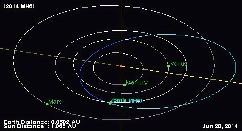
Asteroid 2014 MH6 passed by the Earth at a distance of 247 100 km (0.64 times the average distance between the Earth and the Moon), at about 2.05 pm GMT on Sunday 22 June 2013. There was no...


Follow Sciency Thoughts on Facebook.

At least one dead after Yunnan landslide.

One person is known to have died and at least 15 more are missing following a landslide at Latudi in Fugong County in Yunnan Province, China, at about 9.00 am local time on Monday 30 June 2013. Two other people were reportedly injured in the incident which reportedly occurred at a brickworks (presumably a brick-clay extraction site).

Rescue workers at the scene of the 30 June 2014 Fugong County landslide. Zhong Xin/China News Service.

The incident reportedly occurred following several days of persistent heavy rainfall in Yunnan, which has led to several flash flooding incidents as well as a number of fatalities across the province. Landslides are a common problem after severe weather events, as excess pore water pressure can overcome cohesion in soil and sediments, allowing them to flow like liquids. Approximately 90% of all landslides are caused by heavy rainfall.

The approximate location of the 30 June 2014 Fugong County landslide. Google Maps.

See also...


The United States Geological Survey recorded a Magnitude 5.9 Earthquake at a depth of 10 km in Yingjiang County in eastern Yunnan Province, China, close to the border with Myanmar, at...


Twenty-two miners are reportedly still trapped after a flood at a coal mine at  Dongshan in Yunnan Province on Monday 7 April 2014...


 Four killed by landslide at mine in Yunnan Province, China.

Four workers have been killed and a fifth injured following a landslide at a min in Jinping County, in Yunnan Province, China...


Follow Sciency Thoughts on Facebook.

Pareiasaurs from the Late Permian of Niger, West Africa.

The Pareiasaurs were a diverse and successful group of Parareptiles (an extinct group thought to have been essentially similar to Reptiles, but with no living descendants; all living Reptiles, Mammals and Birds are more closely related to one-another than any is to the Parareptiles) that appeared in the Middle Permian and flourished till the end of the Permian Period, but were wiped out by the End Permian Extinction Event. They are best known from Africa, particularly South Africa, from where nearly half of all described Pareiasaur species originate, but are also known from Zambia, Tanzania, Niger, Malawi and Morocco. Outside of Africa they are known from Brazil, China, Russia, Germany and Scotland.

The Pareiasaur Bunostegos akokanensis was described from a single skull, lacking lower jaws and eroded on the underside, from the Moradi Formation in the Agadez Department of northern Niger in 1888.

In a paper published in the Journal of Vertebrate Paleontology in July 2013, Linda Tsuji and Christian Sidor of the Burke Museum and Department of Biology at the University of Washington, Sébastion Steyer of the Bâtiment de Paléontologie at the Département Histoire de la Terre at the Muséum national d’Histoire naturelle, Roger Smith of Karoo Palaeontology at the Iziko South African Museum, Neil Tabor of the Roy M. Huffington Department of Earth Sciences at Southern Methodist University and Oumarou Ide of the Institut de Recherches en Sciences Humaines, Université de Niamey, describe a series of new specimens of Bunostegos akokanensis collected from the Moradi Formation in 2003 and 2006, and provide a revised description of the species based upon these.

The first new specimen described consists of an almost complete skull lacking its lower jaws, but accompanied by its right scapulocoracoid, and two dorsal vertebrae. The second new specimen comprises a three-dimensionally preserved skull with an eroded upper surface, and the third a braincase and part of the palate. Also described are isolated nasals, an interorbital skull roof, a right ulna, an isolated neural spine, and an isolated osteoderm.

The skull of Bunostegos akokanensis. Photograph and interpretative drawing in (A) dorsal and (B) ventral views. Abbreviations: bo, basioccipital; ec, ectopterygoid; f, frontal; j, jugal; l, lacrimal; m, maxilla; nb, nasal boss; p, parietal; pal, palatine; pf, postfrontal; pm, premaxilla; po, postorbital; pop, paroccipital process of opisthotic; pp, postparietal; ppf, prepalatal foramen; prf, prefrontal; pt, pterygoid; q, quadrate; qj, quadratojugal; sq, squamosal; st, supratemporal; st h, supratemporal ‘horn’; t, tabular; v, vomer. Tsuji et al. (2013).

The skull of Bunostegos akokanensis. Photograph and interpretative drawing in right lateral view. Abbreviations: j, jugal; l, lacrimal; m, maxilla; mf, anterior maxillary foramen; n, nasal; pf, postfrontal; pm, premaxilla; po, postorbital; prf, prefrontal; qj, quadratojugal; sq, squamosal; st, supratemporal. Tsuji et al. (2013).

Based upon this new material Bunostegos akokanensis is determined to be a medium-sized Pareiasaur with two or three dome-shaped bosses near the end of its snout, and horn-like structures above its eyes.

Reconstruction of the skull (A–C) and maxillary tooth (D) of Bunostegos akokanensis. Skull in (A) palatal, (B) dorsal, and (C) right lateral views. (D) tooth in labial view. Scale bar applies only to cranial reconstructions. Tsuji et al. (2013).

Restoration of a subadult Bunostegos akokanensis in life. Marc Boulay in Tsuji et al. (2013).

See also…

 Scavenging on the body of a Dicynodont Therapsid in the Late Permian of the Karoo Basin.

Therapsids were a group of Synapsid Amniotes...

 A Triassic Parareptile from South Africa.

The Parareptiles were a group of early Reptiles that flourished in the Permian. They were heavily depleted in the End Permian Extinction, but did survive into the Triassic. However they were never again a significant part of the fauna and disappeared before the start of the Jurassic, apparently unable to cope with competition from the emerging dinosaurs. The name...


Follow Sciency Thoughts on Facebook.

The Earth reaches its aphelion.

At midnight between Thursday 3 and Friday 4 July 2014 the Earth will reach its aphelion, the furthest point in its orbit from the Sun, a distance of 152 093 481 km. The Earth's orbit is slightly eccentric and slightly variable, leading to the distance between the Earth and the Sun varying by about 3.4% over time, reaching aphelion early in July each year and perihelion (the closest point on its orbit to the Sun) early in January. The exact distance at aphelion and perihelion each year varies, with this year's aphelion being slightly closer to the Sun than last year's, when the Earth reached 152 097 427 km from the Sun on 5 July.

Graphic showing the eccentricities of Mercury, Earth and Mars; the dotted lines represent a circular orbit centered on the Sun, the solid lines the actual orbit. Spaceweather.

This is counter intuitive to inhabitants of the Earth's Northern Hemisphere, who often assume that the Earth is closest to the Sun in midsummer, when in fact it is at its furthest away. This is because the tilt of the Earth plays a far greater role in our seasons than the distance from the Sun, and the Northern Hemisphere has just passed its Summer Solstice, i.e. the point at which the North Pole was pointing as close to the Sun as it ever gets, so that the Northern Hemisphere is currently getting much more sunlight than the Southern. The Earth's surface receives about 7% less sunlight at aphelion to at perihelion, but this is far less than the seasonal variation.

In fact the Earth could potentially move quite a bit in its orbit and still maintain an equitable climate, possibly even if it was as far out as Mars (1.5 AU), though presumably this would be somewhat cooler. Mars is a frozen wasteland largely because it is small and airless. The Earth, being larger, is able to sustain a thicker gaseous atmosphere, leading to a greenhouse effect that keeps the planet warm. Probes on the Red Planet have found abundant geological indicators of running water on the surface, suggesting that ancient Mars had a thicker atmosphere which could support liquid water, but this has now gone, the low gravity of the planet having let it escape molecule by molecule.


See also...


An Annular Eclipse will occur on Tuesday 29 April 2014, starting at about 3.52 am GMT. It will be visible from Australia, much of Antarctica and the southern Indian Ocean, eastern Java and the islands of the Bali, Flores and Savu Seas, though a full Annular...


A total Lunar Eclipse will occur on 15 Aril 2014, starting at about 4.35 am GMT. It will be visible across much of Canada and the United States, as well as all of Mexico and Central America, western South America and many Pacific and Caribbean Islands. Part of the eclipse will be visible from remaining areas of the Americas as...


The planet Mars will make its closest pass to the Earth since December 2007, coming within 92 000 000 km of us on 14 April 2014. This will make the planet a particularly bright object, visible in the night sky from anywhere on Earth in the constellation of Virgo, close to...


Follow Sciency Thoughts on Facebook.

Sunday 29 June 2014

Magnitude 4.2 Earthquake in Sanpete County, Utah.

The United States Geological Survey recorded a Magnitude 4.2 Earthquake at a depth of 5.1 km in Sanpete County, Utah, slightly before 7.00 pm local time on Saturday 28 June 2014 (slightly before 1.00 am on Sunday 29 June, GMT). There are no reports of any damage or casualties associated with this quake, but it was felt over a wide area of central Utah. There have been at least two aftershocks in excess of Magnitude 3.0 since the initial event.

The approximate location of the 28 June 2014 Sanpete County Earthquake. Google Maps.

Utah is in a zone of active mountain orogeny (mountain growth), fueled by the subduction zone on the American West Coast. The state is criss-crossed by faults associated with its many growing mountain ranges, which form part of the Rockies. The rocks of the North American lithosphere are being pushed to the east by seafloor spreading beneath the Pacific and to the west by seafloor spreading beneath the Atlantic. This results in folding and upthrust within the plate, principally in the Rocky Mountains, which run along the western margin of the North American Plate, close to the subduction and fault zones of the continent's west coast. This folding and thrusting leads to frequent Earthquakes throughout the Rocky Mountain region.

Witness accounts of quakes can help geologists to understand these events and the rock structures that cause them. If you felt this quake (or if you wee in the area but did not, which is also useful information) you can report it to the USGS here.

See also...


The United States Geological Survey recorded a Magnitude 3.3 Earthquake at a depth of 11.9 km in Morgan County, Utah...


The United States Geological Survey recorded...

 Magnitude 3.8 Earthquake in Mineral County, Nevada.

The United States Geological Survey recorded a Magnitude 3.8 Earthquake at a depth of 7.8 km in Mineral County in western...


Follow Sciency Thoughts on Facebook.

A Chacoan Peccary from the Late Pleistocene of northern Uruguay.

The Chacoan Peccary (Catagonus wagneri) was first recorded from pre-Columbian archaeological sites in northern Argentina in 1930, and subsequently found to be still living in the dry Chacos thorny forests of northern Argentina, western Paraguay and southeastern Bolivia in the 1970s. The Chacos Forests are hot and dry, with average annual temperatures over 24˚C and average annual rainfall between 80 and 800 mm. The two archaeological sites in northern Argentina where Catagonus wagneri has been recorded are outside the Chacos Forests, but are relatively close and still within areas with a hot dry climate; both are about a thousand years old.

In a paper published in the journal Historical Biology on 18 December 2012, Germán Mariano Gasparini of the División Paleontología Vertebrados at the Museo de La Plata, Martín Ubilla of the Facultad de Ciencias at the Universidad de la República and Eduardo Pedro Tonni, also of the División Paleontología Vertebrados at the Museo de La Plata, describe the skull of a Choacan Peccary from the Late Pleistocene Sopas Formation in Artigas Department in northern Uruguay. 

The specimen comprises a partial skull covered in carbonaceous material (limestone) with most of its teeth intact. The skulls of Catagonus wagneri are quite distict, and there is no doubt about the assignation of this specimen to the species.

Specimen assigned to Catagonus wagneri: (a) Lateral view. (b) Palatal view. (c) Occlusal view of right P2-M3 series. Gasparini et al. (2012).

The Sopas Formation outcrops along streams and rivers in northern Uruguay. It is about 15 m thick and comprises brownish mudstones, siltstones, sandstones and occasionally conglomerates. It has not been dated precisely, but based upon biostratigraphical evidence it is Late Pleistocene, and probably predates the last Glacial Maximum. It has previously yielded other fossils associated with dry climates, such as Camelids and Guinea Pigs, but also species associated with much wetter environments, such as Otters, Tapirs and Capybaras, suggesting that the climate varied considerably during the time period when it was laid down.

Archaeological and paleontological sites where fossil remains of Catagonus wagneri were found and current range. (1) Llajta Maüca archaeological site, 15 km north-west of Melero, Santiago del Estero Province. (2) Tulip-Loman archaeological site, near Icano, Santiago del Estero Province, 45 km south of Llajta Maüca. (3) Paleontological site in the Cuareim river, Artigas Department, Uruguay. (a) Mariscal Estigarribia, Boquerón Department, Paraguay. (b) Las Lomitas, Formosa Province, Argentina. Grey area: current range of Catagonus wagneriGasparini et al. (2012).

See also


A diverse fauna of Musk Oxen (Ovibovines) is known from the Late Miocene of China, each showing distinct and specialized horn cores (the bone core upon which the keratin horn is supported; the diversity of horn core shapes can be used to infer a diversity of horn shapes, even in the absence of horns), but otherwise quite similar. One of...


Pigs (Suidae) are found throughout the Old World. They are members of the Artiodactyla, the group that also includes Cattle, Deer and Antelopes (and, curiously, Whales), though they are considered less highly derived than other members of the group, lacking a rumen (additional stomach compartment) and retaining four toes on each foot (though two of these are...


The Przewalski’s Gazelle (Procapra przewalskii) is a species of high altitude adapted Antelope, which formerly ranged across much of...


Follow Sciency Thoughts on Facebook.

Asteroid 2014 MZ5 passes the Earth.

Asteroid 2014 MZ5 passed by the Earth at a distance of about 9 908 000 km (25.78 times the average distance between the Earth and the Moon), slightly after 3.50 pm GMT on Sunday 22 June 2014. There was no danger of the asteroid hitting us, though were it to do so it would have presented a moderate threat. 2014 MZ5 has an estimated equivalent diameter of 30-94 m (i.e. it is estimated that a spherical object with the same volume would be 30-94 m in diameter), and an object towards the upper end of this range would be predicted to be capable of passing through the Earth's atmosphere relatively intact, impacting the ground with an energy equivalent to about 35 megatons of TNT (roughly 2050 times the energy of the Hiroshima bomb). Such an event would result in a crater about a kilometer across, cause devastation over a wide area around the impact site and would have the potential to affect the climate globally for several years.

The calculated orbit of 2014 MZ5. JPL Small Body Database Browser.

2014 MZ5 was discovered on 21 June 2014 (the day before its closest approach to the Earth) by the University of Arizona's Mt. Lemmon Survey at the Steward Observatory on Mount Lemmon in the Catalina Mountains north of Tucson.. The designation 2014 MZ5 implies that it was the 150th asteroid (asteroid Z5) discovered in the second half of June 2014 (period 2014 M).

While 2014 MZ5 occasionally comes near to the Earth, it does not actually cross our orbital path. It has an elliptical 486 day orbit, tilted to the plane of the Solar System, that takes it from 1.08 AU from the Sun (1.08 times the distance at which the Earth orbits the Sun), slightly outside our orbit, to 1.34 AU from the Sun, (1.34 times the distance at which the Earth orbits the Sun, still inside the orbit of the planet Mars). As a Near Earth Object that remains strictly outside the orbit of the Earth it is classed as an Amor Family Asteroid. This means that close encounters between the asteroid and Earth are fairly common, with the last thought to have happened in June 2010 and the next predicted in June 2018.

See also...


Comet C/2014 E2 (Jacques) will reach its perihelion (the closest point on its orbit to the Sun)  on Thursday 3 July 2014, reaching its brightest in the sky (seen from Earth) a later in July, when it should...


Asteroid 2014 MH6 passed by the Earth at a distance of 247 100 km (0.64 times the average distance between the Earth and the Moon), at about 2.05 pm GMT on Sunday 22 June 2013. There was no...


Asteroid 2014 MP passed by the Earth at a distance of 3 483 000 km (9.05 times the average distance between the Earth and the Moon), slightly before 5.40 am GMT on Sunday 22 June 2013. There was...


Follow Sciency Thoughts on Facebook.

Two killed by dust storms in Uttar Pradesh, India.

Two people have died in separate incidents in the Barabanki District of Uttar Pradesh, India, after the area was struck by severe dust storms on 28 June 2014. Both died as a result of trees being pushed over by high winds, with a 55-year-old woman identified only as Sumitra being killed in her sleep after her home was struck by one tree and a 10-year-old boy named as Surendra billing killed by another while picking Mangoes in an orchard.

The location of the Barabanki District. Google Maps.

Dust storms are a common phenomena in arid regions, and are caused by high winds lifting particles from the ground. These are common in Uttar Pradesh in the summer season, a three month hot period lasting from March to June, when temperatures can pass 45° but humidity remains low, and high winds are particularly common ahead of the onset of the monsoon season.

See also...


At least seven people have died following torrential rainfall overnight in the city of Guwahati in Assam State, northeast India. Three people...


Parts of the Indian city of Mumbai are suffering from flooding after being hit by a series of freak waves on Thursday 12 June 2014. The waves occurred around high tide, and rose over four meters above...


At least thirteen people have been killed by lightning in West Bengal during the last week, and over twenty more have been injured as the annual kalboishakhi storms swept across the state. Most of those...


Follow Sciency Thoughts on Facebook.

Activity on Mount Mayon, Philippines.

The Philippine Institute of Volcanology and Seismology has recorded an increase in seismic activity over the past 24 hours (Saturday 28-Sunday 29 June 2014) beneath Mount Mayon, a 2463 m stratovolcano (cone shaped volcano) on southern Luzon Island. White smoke has also been seen issuing from the summit of the volcano, though the alert level has not yet been raised.

White smoke issuing from the summit of Mount Mayon at about 11.00  am on 29 June 2014. GMA News.

Mayon is considered to be a particularly due to the dense population in the area surrounding it. It has a long history of causing fatalities, most recently in 7 May 2013, when a sudden eruption caught a party of tourists by surprise, leading to five fatalities. As well as the direct danger from volcanic eruptions, Mayon has been the cause of numerous lahars (ash-laden flash foods). These tend to occur when ash from the volcano builds up across the path of seasonal waterways during the dry season, leading to temporary damming of water courses then flash floods at the start of the rainy season.

The location of Mount Mayon. Google Maps.

The geology of the Philippines is complex, with the majority of the islands located on the east of the Sunda Plate. To the east of this lies the Philippine Sea plate, which is being subducted beneath the Sunda Plate; further east, in the Mariana Islands, the Pacific Plate is being subducted beneath the Philippine Sea Plate. 

See also...


The United States Geological Survey recorded a Magnitude 7.1...


Five people are reported to have been killed in an eruption on Mount Mayon, an active stratovolcano (cone shaped volcano) on Luzon Island in the Philippines. The five, who have been described as four German tourists and a local guide, were part of a group of 20 people who were approaching the summit  of the volcano, when they were caught by a...


Follow Sciency Thoughts on Facebook.
Comet C/2014 E2 (Jacques) reaches perihelion.

Comet C/2014 E2 (Jacques) will reach its perihelion (the closest point on its orbit to the Sun)  on Thursday 3 July 2014, reaching its brightest in the sky (seen from Earth) a later in July, when it should be possible to see the comet with binoculars in the constellations of Taurus and Auriga. C/2014 E2 (Jacques) will make a close pass of the planet Venus on 13 July, and be at its closest to Earth on 28 August, though it will still be more than 0.5 AU away (equivalent to half the distance between the Earth and the Sun).

C/2014 E2 (Jacques) imaged on 17 April 2014 by Michael Jäger from Stixendorf in Austria. Spaceweather.

C/2014 E2 (Jacques) was discovered on 13 March 2014 by Cristóvão Jacques Lage de Faria, Eduardo Pimentel and João Ribeiro de Barros working at the Southern Observatory for Near Earth Asteroids Research in Minas Gerais State, Brazil. The name C/2014 E2 (Jacques) implies that it is a non-periodic comet (C/) (all comets are, strictly speaking, periodic since they all orbit the Sun, but those with periods longer than 200 years are considered to be non-periodic), that it was the second comet (comet 2) discovered in the first half of March 2014 (period 2014 E), and that it was discovered by Jacques.

Star chart showing the position of C/2014 E2 (Jacques) in the sky as seen from Earth from May 2014 to February 2015. In the sky.

C/2014 E2 (Jacques) is calculated to have a 21 424 year orbital period and a highly eccentric orbit that takes it from 0.66 AU from the Sun at perihelion (66% of the distance between the Earth and the Sun, slightly inside the orbit of Venus) to 1542 AU from the Sun at aphelion, which is 1542 times as far from the Sun as the Earth, over 500 times as far from the Sun as Neptune, 300 times as far from the Sun as the outer limit of the Kuiper Belt, but still within the inner Oort Cloud.

The passage of C/2014 E2 (Jacques) through the Inner Solar System. JPL Small Body Database Browser.

See also...


Faye's Comet (Comet 4P/Faye) reached it's perihelion (the closest point in its orbit to the Sun) on 29 May 2014, for the first time in seven-and-a-half years. It presents no danger to the Earth, as it never comes within... 


Comet 17P/Holmes is a Jupiter Family Comet with a 6.89 year orbit that takes it from 2.06 AU from the Sun (2.06 times the average distance at which the Earth orbits the Sun, considerably outside the orbit of Mars) to 5.18 AU from the Sun (slightly inside the orbit of Jupiter). Since its discovery in 1892 it has been observed to...


Comet ISON (C/2012 S1) was discovered in September 2012 by Vitali Nevski and Artyom Novichonok of the International Scientific...


Follow Sciency Thoughts on Facebook.