Showing posts with label East Java. Show all posts

Wednesday, 19 November 2025

Eruption on Mount Semeru.

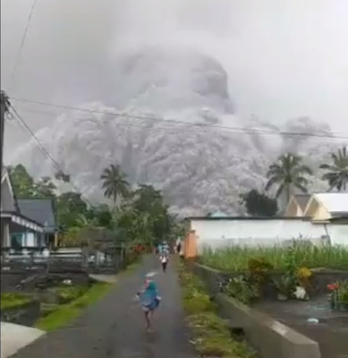
People living close to Mount Semeru, a 3676 m high stratovolcano (cone-shaped volcano made up of layers of ash and lava) close to the city of Lumajang in East Java, have been advised to avoid going near the volcano, following an eruption on Wednesday 19 November 2025. The volcano began erupting at about 4.00 pm local time (about 9.00 am GMT) producing an ash column about 5.6 km high, and triggering a series of pyroclastic flows (avalanches of hot rock, ash and gas) which reached as far as 7.00 km from the volcano.

A column of Ash above Mount Semeru on 19 October 2025. Badan Geologi/AP.

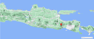
Mount Semeru forms part of the Tengger Volcanic Complex is a string of five overlapping stratovolcanoes (cone-shaped volcanoes) forming a single massif, extending northward from Semeru. The whole massif sits within a vast caldera (volcanic crater), left by the explosion of an ancient volcano about 150 000 years ago. The volcanoes are at the center of this caldera, surrounded by a vast sea of sand, the Tengger Sand Sea.

The approximate location of Mount Semeru. Google Maps.

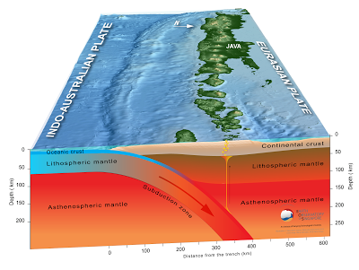
The Indo-Australian Plate, which underlies the Indian Ocean to the south of Java, is being subducted beneath the Sunda Plate, a breakaway part of the Eurasian Plate which underlies Java and neighbouring Sumatra, along the Sunda Trench, passing under Java, where friction between the two plates can cause Earthquakes. As the Indo-Australian Plate sinks further into the Earth it is partially melted and some of the melted material rises through the overlying Sunda Plate as magma, fuelling the volcanoes of Java and Sumatra.

Subduction along the Sunda Trench. Earth Observatory of Singapore.

See also...

Saturday, 4 December 2021

Indonesan authorities begin evacuations after eruption on Mount Semeru, East Java.

Authorities in East Java, Indonesia, have begun evacuating communities close to Mount Semeru, a stratovolcano (cone-shaped volcano made up of layers of ash and lava) close to the city of Lumajang which forms the highest point on the island, following a sudden eruption on Saturday 4 December 2021. The eruption produced an ash column that rose to about 15 000 m, leading to heavy ash-falls in several local communities. There are no reports of any casualties at this time, although a bridge connecting Lumajang to Malang has been either damaged or swept away, according to posts on social media. The Darwin Volcanic Ash Advisory Center has reported that the ash cloud appears to have become detached from the volcano, and is drifting to the southwest.

 
An ash cloud generated by an eruption on Mount Semeru, East Jave, on 4 December 2021. Daily Sabah/Twitter.

Mount Semeru forms part of the Tengger Volcanic Complex is a string of five overlapping stratovolcanoes (cone-shaped volcanoes) forming a single massif, extending northward from Semeru. The whole massif sits within a vast caldera (volcanic crater), left by the explosion of an ancient volcano about 150 000 years ago. The volcanoes are at the center of this caldera, surrounded by a vast sea of sand, the Tengger Sand Sea.

 
The approximate location of Mount Semeru. Google Maps.


Follow Sciency Thoughts on Facebook.

Follow Sciency Thoughts on Twitter. 


Saturday, 10 April 2021

Magnitude 6.0 Earthquake to the south of Gongdanglegi Kulon, East Java.

The United States Geological Survey recorded a Magnitude 6.0 Earthquake at a depth of 82.3 km to the south of the village of Gondanglegi Kulon in East Java, Indonesia, slightly after 2.00 pm local time (slightly after 7.00 am GMT) on Saturday 10 April 2021. The event was felt across most of Java, as well as on Bali and Lombok islands, but there are no reports of any damage or casualties.

 
The approximate location of the 10 April 2021 East Java Earthquake. USGS.

The Indo-Australian Plate, which underlies the Indian Ocean to the south of Java, Bali and Lombok, is being subducted beneath the Sunda Plate, a breakaway part of the Eurasian Plate which underlies the islands and neighbouring Sumatra, along the Sunda Trench, passing under the islands, where friction between the two plates can cause Earthquakes. As the Indo-Australian Plate sinks further into the Earth it is partially melted and some of the melted material rises through the overlying Sunda Plate as magma, fuelling the volcanoes of Java and neighbouring islands.

 
Subduction along the Sunda Trench beneath Java, Bali and Lombok. Earth Observatory of Singapore.

See also...


Follow Sciency Thoughts on Facebook.

Follow Sciency Thoughts on Twitter. 


Thursday, 17 March 2016

Cyrtodactylus petani: A new species of Bent-toed Gecko from East Java.

Bent-toed Geckos of the genus Cyrtodactylus are found across much of Southeast Asia. Recent studies have revealed the group to contain many cryptic species (species which closely resemble other species and which can only be differentiated by close morphological examination or genetic analysis), which has revealed that many long established species within the group are in fact species groups made up of several similar but genetically distinct species. To date all members of the genus from Java have been referred to two species, Cyrtodactylus fumosus and Cyrtodactylus marmoratus, though it has been suspected for some time that this may not reflect the true diversity of the genus on the island.

In a paper published in the journal Zootaxa on 22 December 2015, Awal Riyanto of the Museum Zoologicum Bogoriense of The IndonesianInstitute of Sciences, Lee Grismer of the Department of Biology at LaSierra University and Perry Wood of the Department of Biology at Brigham Young University, describe a new species of Cyrtodactylus from East Java.

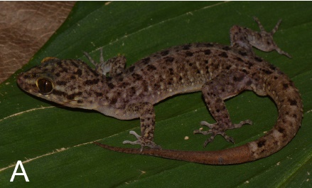
The new species is named Cyrtodactylus petani, where 'petani' means 'farmer' in Indonesian; the specimens from which the species is described having lived on farmland. The populations from which the species is described were previously assigned to Cyrtodactylus fumosus, and are similar, though the species can be differentiated by physical examination; Cyrtodactylus petani being slightly shorter and having a different pattern of scales. The animals have a camouflaged pattern, with brown, black and yellowish scales forming bands along the back and a lighter underside. The species was found in a number of habitats, including embankments in paddy fields, rocks and trees in farm gardens, rocks on a dry riverbed, artificial (cement) riverbanks and trees in teak woodland, though always close to the ground. The species is clearly highly adaptable, and able to colonise disturbed, man-made environments as well as natural ones.

Cyrtodactylus petani, male speciemen from Jeladri Village in Pasuruan District, East Java. Riyanto et al. (2015).

See also...
http://sciencythoughts.blogspot.co.uk/2015/08/calcified-lizard-eggs-with-preserved.htmlCalcified Lizard eggs with preserved embryos from the Early Cretaceous of Thailand.                                                                        Among living Vertebrate groups, Lizards show the most diverse range of reproductive strategies, with species known that reproduce sexually...
http://sciencythoughts.blogspot.co.uk/2014/11/a-new-species-of-velvet-gecko-from.htmlA new species of Velvet Gecko from the southern Kimberley of Western Australia. Velvet Geckos of the genus Oeduraare medium to large Geckos found across much of northern and eastern Australia, with isolated populations in the arid interior...
Phasmid Geckos are small climbing Geckos of the genus Strophurus found across much of northern Australia, where they inhabit stands of...
Follow Sciency Thoughts on Facebook.

Saturday, 11 July 2015

Indonesian airports closed by volcanic activity on Mount Raung, East Java.

Authorities in Indonesia have been forced to close several airports in East Java and Bali following a series of eruptions on Mount Raung, an active volcano in East Java. There are no reports of any damage or casualties associated with the eruptions, however volcanic ash is extremely hazardous to aircraft in a number of ways. At its most obvious it is opaque, both visually and to radar. Then it is abrasive, ash particles physically scour aircraft, damaging components and frosting windows. However the ash is most dangerous when it is sucked into jet engines, here the high temperatures can melt the tiny silica particles, forming volcanic glass which then clogs engine. When this happens the only hope the aircraft has is to dive sharply, in the hope that cold air passing through the engine during the descent will cause the glass to shatter, allowing the engine to be restarted.

Ash issuing from the summit of Mount Raung on 10 July 2015. AP.

Raung is a 3332 m stratovolcano (cone shaped volcano made of layers of ash and lava in East Java. It is a highly active volcano, typically erupting two or three times per decade.  The latest eruptive episode began on 24 July 2014, and as well as causing disruption to air travelers, has resulted in the production of a lava lake in the volcano's caldera; this is thought unlikely to overtop the caldera (which is roughly 2 km wide and 500 m deep) but a 3 km exclusion zone around the volcano has been put in place as a precaution.

The approximate location of Mount Raung. Google Maps.

The Indo-Australian Plate, which underlies the Indian Ocean to the south of Java, is being subducted beneath the Sunda Plate, a breakaway part of the Eurasian Plate which underlies Java and neighbouring Sumatra, along the Sunda Trench, passing under Java, where friction between the two plates can cause Earthquakes. As the Indo-Australian Plate sinks further into the Earth it is partially melted and some of the melted material rises through the overlying Sunda Plate as magma, fuelling the volcanoes of Java and Sumatra.

Subduction along the Sunda Trench. Earth Observatory of Singapore.

See also...

A student at Atma Jaya University in Yogyakarta is believed to have died after falling into the crater of Mount Merapi in Central Java on Saturday 16 May 2015. Eri Yunanto, 21, who was studying at the university's Technical Industry School had ascended the...

Four people have been confirmed dead and another nine are missing following an explosion on a...

Indonesian authorities have raised the alert level on Mount Slamet, an active volcano in Central Java, to three (out of a possible four), after a series of eruptions this week. The volcano began a new eruptive cycle in March, but has become notably more active over the...


Follow Sciency Thoughts on Facebook.

Thursday, 11 October 2012

Activity in the Tengger Caldera.

The Tengger Volcanic Complex is a string of five overlapping stratovolcanoes (cone-shaped volcanoes) forming a single massif, extending northward from the Semeru Volcano in East Java. The youngest and most active of these being Mount Bromo. The whole massif sits within a vast caldera (volcanic crater), left by the explosion of an ancient volcano about 150 000 years ago. The volcanoes are at the center of this caldera, surrounded by a vast sea of sand, the Tengger Sand Sea, and forms part of the Bromo Tengger Semeru National Park.

(Top) Modern terrain map showing the Semeru Volcano, the Tengger Caldera and the surrounding area. Google Maps. (Bottom) Junghuhn's 1844 map of the Caldera. Wikipedia. 

The volcano is one of Java's most active, having undergone at least 50 explosive eruptions since 1804, the most recent of which was in June 2011. The volcano has been more-or-less quiet since March this year (2012) when a number of white plumes where seen over the caldera. During September and early October, a number of white plumes where again seen over the Caldera, rising as high as 50 m above the Bromo crater. During early October sulphurous smells were also recorded in the area, and a number of small tremors recorded (such tremors are important near volcanoes, as they may reflect movement in underground magma chambers).

A view of the Tengger Caldera from the north, showing the smaller stratovolcanoes within; a small plume is issuing from Mount Bromo to the left. The peak in the foreground is Mount Batok, the larger peak in the background is the Semeru Volcano, which is to the south of the Caldera. The Malay Archipelago.

Java lies on the southern part of the Sunda Plate, to the north of the Sunda, or Java, Trench, along which the Indo-Australian Plate is being subducted beneath the Sunda Plate. As the Indo-Australian Plate sinks into the Earth it is heated by friction with the overlying Sunda Plate and the heat of the Planet's interior, which causes the plate to partially melt. Some of the melted material then rises through the overlying Sunda Plate, fueling the volcanoes of Java, and Sumatra to the northeast.

The passage of the Indo-Australian Plate beneath Sumatra. Auburn University.

See also Eruption on Mount Marapi, Sumatra, Eruptions on Krakatau, Large Earthquake to the south of East Java, Seismic activity beneath Mount Tangkubanparahu and Volcanoes on Sciency Thoughts YouTube.

Follow Sciency Thoughts on Facebook.