Showing posts with label Mount Ibu. Show all posts

Sunday, 19 January 2025

Evacuations ordered after increase in activity from Mount Ibu on Halmahera Island, Indonesia.

Authorities in North Maluku Province, Indonesia, have ordered the evacuation of six villages close to Mount Ibu, a 1325 m stratovolcano on the northwest coast of Halmahera Island, following a series of eruptions in the first two weeks of 2025. Mount Ibu began its current eruptive cycle in June 2024, but January has seen a significant rise in activity, with more than a thousand eruptions have been recorded on the volcano this year, with the largest producing ash columns reaching as high as 4 km over the summit of the volcano. However, to date only one village, with a population of 517 people, has been evacuated, with about 2500 people in the remaining five villages reluctant to leave without first harvesting crops.

An eruption on Mount Ibu, Halmahera Island, on Wednesday 15 January 2024. Azzam/AFP.

The Halmahera Island chain is a volcanic arc formed where the Halmahera Plate, a northeaster extension of the Molucca Sea Plate is being subducted beneath Philippine Plate from the east and the Eurasian Plate from the west, with the underlying plate being melted by the heat of the Earth's interior, and lighter minerals bubbling up through the overlying plate to form volcanoes. The Halmahera volcanoes are located where the Philippine Plate is overriding the Molucca Sea Plate; to the west the Sangihe Islands lie where the Molucca Sea Plate is being overridden by the Eurasian Plate.
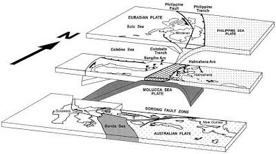
Diagrammatic representation of the subduction zones beneath Halmahera (middle), plus the Philippines (top) and Sulawesi (bottom), with the Eurasian Plate to the left, the Molucca Sea Plate in the middle, and the Philippine Plate to the right.  Hall & Wilson (2000).

See also...

Sunday, 19 May 2024

Exclusion area around Mount Ibu, Halmahera Island, extended following new eruption.

The Indonesian Center for Volcanology and Geological Hazard Mitigation has extended the exclusion zone around  Mount Ibu, a 1325 m stratovolcano on the northwest coast of Halmahera Island, following a new eruption on 18 May 2024. A two kilometre exclusion zone had already been put in place after the volcano began erupting on 28 April, but this has been increased to seven kilometres following the most recent eruption, which produced an ash column which rose to 4 km above the volcano's summit, resulting in seven villages needing to be evacuated. 

An ash column and lava fountain above Mount Ibu on the Indonesian island of Halmahera on 18 May 2024. Several lightning discharges can be seen within the ash column; ash columns can build up considerable charge variations leading to frequent electrical discharges. Indonesian Center for Volcanology and Geological Hazard Mitigation/Reuters.

The Halmahera Island chain is a volcanic arc formed where the Halmahera Plate, a northeaster extension of the Molucca Sea Plate is being subducted beneath Philippine Plate from the east and the Eurasian Plate from the west, with the underlying plate being melted by the heat of the Earth's interior, and lighter minerals bubbling up through the overlying plate to form volcanoes. The Halmahera volcanoes are located where the Philippine Plate is overriding the Molucca Sea Plate; to the west the Sangihe Islands lie where the Molucca Sea Plate is being overridden by the Eurasian Plate.

Diagrammatic representation of the subduction zones beneath Halmahera (middle), plus the Philippines (top) and Sulawesi (bottom), with the Eurasian Plate to the left, the Molucca Sea Plate in the middle, and the Philippine Plate to the right.  Hall & Wilson (2000).

See also...

Monday, 29 April 2024

Eruption on Mount Ibu, Halmahera Island, Indonesia.

The Regional Disaster Mitigation Agency for West Halmahera District has reported an eruption on Mount Ibu, a 1325 m stratovolcano on the northwest coast of Halmahera Island, Indonesia, on Sunday 28 April  2024 (a stratovolcano is a cone-shaped volcano made up of layers of ash and lava, although Mount Ibu has a truncated shape, having lost its upper part in an explosion at some point in the past). The eruption started at 0.37 am local time, and lasted approximately three minutes and 26 seconds, producing a column of dark ash which rose 3.5 km above the summit of the volcano and drifted to the west. The Regional Disaster Mitigation Agency has asked people not to go within 2 km of the volcano for the time being, and has issued dust masks to residents of 16 villages in the area. Sam Ratulangi International Airport, about 100 km from the volcano in the city of Manado, is closed to flights temporarily.

An ash column over Mount Ibu at 0.44 am local time on Sunday 28 April 2024. Abdul Fatah/Antara News Agency.

The Halmahera Island chain is a volcanic arc formed where the Halmahera Plate, a northeaster extension of the Molucca Sea Plate is being subducted beneath Philippine Plate from the east and the Eurasian Plate from the west, with the underlying plate being melted by the heat of the Earth's interior, and lighter minerals bubbling up through the overlying plate to form volcanoes. The Halmahera volcanoes are located where the Philippine Plate is overriding the Molucca Sea Plate; to the west the Sangihe Islands lie where the Molucca Sea Plate is being overridden by the Eurasian Plate.

Diagrammatic representation of the subduction zones beneath Halmahera (middle), plus the Philippines (top) and Sulawesi (bottom), with the Eurasian Plate to the left, the Molucca Sea Plate in the middle, and the Philippine Plate to the right.  Hall & Wilson (2000).

See also...

Friday, 1 September 2017

Eruptions on Mount Ibu, Halmahera, Indonesia.

The Darwin Volcanic Ash Advisory Center has reported eruptions on Mount Ibu, a stratovolcano (cone-shaped volcano made up of layers of volcanic ash and lava) on the northwest coast of Halmahera Island, Indonesia, on Thursday 24 and Monday 28 August 2017. Both eruptions were identified from ash plumes that rose 1.5-1.8 km above the summit of the 1325 m volcano and drifted to the west.

The approximate location of Mount Ibu. Google Maps.

The Halmahera Islands arc a volcanic arc; formed where one tectonic plate is being subducted beneath another, with the underlying plate being melted by the heat of the Earth's interior, and lighter minerals bubbling up through the overlying plate to form volcanoes. However the Halmahera Islands are unusual in that they lie on a double subduction zone. The underlying plate, a northeaster extension of the Molucca Sea Plate, is being overridden form the Philippine Plate from the east and the Eurasian Plate from the west. The Halmahera volcanoes are located where the Philippine Plate is overriding the Molucca Sea Plate; to the west the Sangihe Islands lie where the Molucca Sea Plate is being overridden by the Eurasian Plate.

 Diagrammatic representation of the subduction zones beneath Halmahera (middle), plus the Philippines (top) and Sulawesi (bottom), with the Eurasian Plate to the left, the Molucca Sea Plate in the middle, and the Philippine Plate to the right.  Hall & Wilson (2000).

See also...

http://sciencythoughts.blogspot.co.uk/2013/11/magnitude-62-earthquake-off-north-coast.htmlhttp://sciencythoughts.blogspot.co.uk/2013/10/eruptions-on-mount-dukono-on-halmahera.html
http://sciencythoughts.blogspot.co.uk/2013/09/eruptions-on-mount-dukono.htmlhttp://sciencythoughts.blogspot.co.uk/2012/09/eruption-on-gamalama.html
http://sciencythoughts.blogspot.co.uk/2011/12/volcanic-activity-in-halmahera-islands.html
Follow Sciency Thoughts on Facebook.