
Slightly before 11.50 am, local time (slightly before 3.50 am, GMT), on Monday 6 February 2012, the Philippine Islands of Cebu and Negros were shaken by an Earthquake measured by the United States Geological Survey as a 6.7 on the Richter Scale at a depth of 20 km, midway between the islands. Local press have widely reported this as a magnitude 6.9 quake, which may come from the Philippine Institute of Volcanology and Seismology, though their website is down at the time of writing, making this hard to check. The quake has been followed by a number of severe aftershocks, one at 6.10 pm, local time (10.10 am, GMT), measuring 6.0 on the Richter Scale according to the United States Geological Survey.
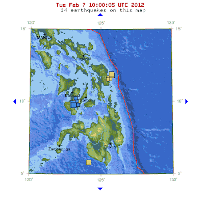
Map showing the location of the quakes, cluster of blue squares. The first quake is the yellow square behind the blue squares, other yellow squares represent other quakes within the last week. The red line is the Philippine Trench, where the Philippine Sea Plate to the east is being subducted beneath the Philippine Mobile Belt, on which most of the Philippine Islands sit. From the United States Geological Survey.
At the time of writing the official death toll from the quake is 15, with unofficial sources giving numbers as high as 52. Official figures also give 71 missing, 52 hospitalized and many hundreds more injured. The majority of the deaths are likely to have been caused by landslides, though there is apparently also widespread damage to buildings and bridges. The full extent of the destruction will probably not be known for several days. At the time of the initial quake there was widespread fear that it would be followed by a dangerous tsunami, but this did not occur.
Sudden inrush of water in Cebu, following the quake; technically this is a tsunami, but not life-threatening. Irene Nipaya, Balamban, Cebu.
The geology of the Philippines is complex, with the Philippine Sea Plate to the east and the Sunda Plate to the west both being subducted beneath the Philippine Mobile Belt, on which most of the islands sit. The Mobile Belt is slowly being pulled in several different directions by this, and geologists have mapped hundreds of faults in the islands - often by measuring quakes. On this occasion the quake may have revealed a previously unknown fault, according to Ishmael Narag of the Philippine Institute of Volcanology and Seismology's Seismological Observation and Earthquake Prediction Division.

Map of the Philippines showing Subductive Margins (Trenches) and known faults. From the Philippine Institute of Volcanology and Seismology.
See also Earthquake shakes Yamanashi Prefecture, Explosion on Suwanosejima, Earthquake in the Babuyan Islands of the Northern Philippines, Eruptions from the Tompaluan Crater and Earthquakes on Sciency Thoughts YouTube.


