
The Wellington Volcanic Ash Advisory Center reported an eruption on Mount Tinakula, an uninhabited island stratovolcano (cone-shaped volcano made up of layers of ash and lava) at the north end of the Santa Cruz Islands (part of the Solomon Islands), on the morning of Saturday 21 October 2017, which produced an ash column that rose to a height of 4.6 km and drifted to the north. A second, larger, eruption about four hours later produced an ash column that rose to a height of 10.7 km. Eruptions on the island continued for the rest of the week, producing ash falls on the islands of Fenualoa, and Nupani, and tainting water supplies in parts of the Reef Islands.

Satellite image of an ash column over Mount Tinakula taken by the MODIS camera on the Terra Satellite on 28 October 2017. Position of volcano indicated by yellow triangle. NASA/Volcano Discovery.
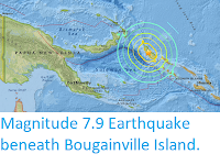
The Santa Cruz Islands lie on the boundary between the Australian Plate (to the south) and Pacific Plate (to the north). The Australian Plate is moving northward relative to the Pacific Plate, and being subducted beneath it. As the plate sinks further it is partially melted by the heat of the
friction combined with that of the Earth's interior. Some of the melted
material then rises through the overlying Pacific Plate, fuelling the
volcanoes of the Santa Cruz Islands.
See also...


Follow Sciency Thoughts on Facebook.