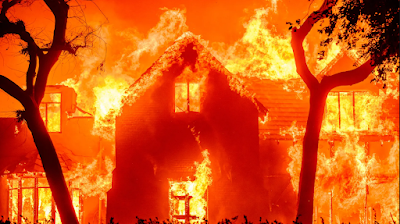
Five people have been confirmed dead and others may have lost their lives as more than 2000 homes have been destroyed in a series of wildfires which have swept across Los Angeles County in Southern California since Tuesday 7 January 2025. Around 180 000 further people have been ordered to evacuate their homes, with another 200 000 warned this may be necessary, amid concerns that these will also be lost, many of them in Los Angeles's wealthiest suburbs. Around 400 000 people have had their electricity supplies either disrupted or cut off completely.
The second fire reported, now named the Palisades Fire, was reported at about 10.30 am on 7 January in the Palisades Hills to the northwest of Santa Monica. This has subsequently spread to cover an area of about 55 km², affecting the communities of Santa Monica, Malibu, and Calabasas, with initial efforts to contain it hampered by high winds, which both helped the fire to spread quickly and prevented fire fighting aircraft from approaching the area. The problems faced by firefighters worsened as the area's fire hydrant system became exhausted by the demand being placed upon it, causing pressure to fall and fire hoses to run dry.
At about 6.20 pm the Eaton Fire was reported in the Eaton Canyon Falls area to the northeast of Pasadena. This fire has now spread to cover an area of about 40 km², again with high winds and an over-used fire hydrant system severely hampering efforts to contain the fire. All five known fatalities have been caused by the Eaton Fire in the Altadena neighbourhood, although local officials are warning that there are probably many more dead around the county.
At about the 10.30 the Hurst Fire was reported in the San Fernando Valley to the north of Los Angeles. This has spread to cover almost 3 km² of land and is only partially controlled, leading to a large area being evacuated. Some witnesses have reported seeing an explosion at an electrical distribution centre, possibly caused by high winds blowing power cables loose, but this is still under investigation,
The Lidia Fire was reported slightly after 6.00 am on Wednesday 8 January, close to the town of Ravenna to the north of the Angeles National Forest. This fire has spread to cover about 1.5 km² of land, and is only partially under control, provoking some evacuations. The Woodley Fire was reported at 6.15 am on Wednesday 8 January in the Woodley Recreation Area, to the north of Encino. This eventually burned about 121 400 m² of wood- and parkland before being brought under control. The Sunset Fire was reported slightly before 6.00 pm on Wednesday 8 January, and has spread to cover 170 m² of land, provoking further evacuations and threatening some of Holywood's most iconic landmarks.
The fires affecting Los Angeles (and other parts of California) are largely a result of several years of unusually hot and dry weather, which in turn have been driven by rising global temperatures. However, they have also been driven by extremely strong Santa Ana winds, a form of katabaric (downhill) wind driven by the Californian landscape. The interior of California is elevated, and has a dry climate compared to coastal areas. During periods of cool weather high pressure zones can form in these dry highlands, and if these coincide with a low pressure system in coastal areas, then the winds flow downhill, gaining heat (and, typically, quite a bit of dust) before reaching lowland coastal areas.
See also...


.jpg)
.jpg)

.jpg)


