Showing posts with label Dead Sea Transform Margin. Show all posts

Saturday, 1 November 2025

Magnitude 6.0 Earthquake in Balıkesir Province, Turkey.

The United States Geological Survey recorded a Magnitude 6.0 Earthquake at a depth of 8.0 km, about 4 km to the southeast of the municipality of Sındırgı in Balıkesir Province, Turkey,  slightly before 10.,50 pm local time (slightly before 7.50 pm GMT) on Monday 27 October 2025. No casualties have been reported following this event, but several buildings damaged during another Earthquake in August are reported to have collapsed. The Earthquake was felt across western Turkey, and in parts of southern Bulgaria.

The approximate location of the 27 October 2025 Balıkesir Province Earthquake. USGS.

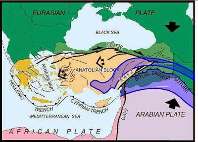
Balıkesir Province lies close to the boundary between the Anatolian Plate, to the north, the Aegean Sea Plate (underlying the Peloponnese, Attica, The Cyclades Islands, Crete, the Dodecanese Islands and Turkey to the southeast of the Taurus Mountains) to the west and the African Plate to the south. Northern Greece and the north coast of Turkey lie on the Eurasian Plate. Both countries are highly prone to earthquakes because of this.

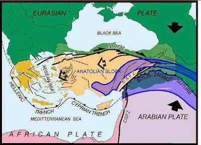
To the east the Arabian Plate  is being pushed north and west by the movement of the African Plate, further to the south. This leads to a zone of tectonic activity within the province, as the Arabian and Anatolian plates are pushed together, along the East Anatolian Fault, and past one-another, along the Dead Sea Transform.

Simplified map of the plate movements of the eastern Mediterranean. Univeriteit Utrecht.

This movement also leads to a zone of faulting along the northern part of Turkey, the North Anatolian Fault Zone, as the Anatolian Plate is pushed past the Eurasian Plate, which underlies the Black Sea and Crimean Peninsula  (transform faulting). This is not a simple process, as the two plates constantly stick together, then break apart as the pressure builds up, leading to Earthquakes, which can be some distance from the actual fault zone. 

See also...

Wednesday, 13 August 2025

At least one fatality following Magnitude 6.1 Earthquake in eastern Turkey.

The United States Geological Survey recorded a Magnitude 6.1 Earthquake at a depth of 10.0 km, about 10 km to the southwest of the municipality of Bigadiç in Balıkesir Province, Turkey,  slightly before 7.55 pm local time (slightly before 4.55 pm GMT) on Sunday 10 August 2025. Sixteen buildings are reported to have collapsed following the event, although the majority are reported to have been derelict before the event, with at least one fatality, an 81-year-old woman who died after being rescued from the remains of a collapsed building, with 29 more people having been injured.

Local residents removing debris from collapsed buildings following an Earthquake in northeast Turkey on 10 August 2025. Bahadir Demirçeriven/AP.

Balıkesir Province lies close to the boundary between the Anatolian Plate, to the north, the Aegean Sea Plate (underlying the Peloponnese, Attica, The Cyclades Islands, Crete, the Dodecanese Islands and Turkey to the southeast of the Taurus Mountains) to the west and the African Plate to the south. Northern Greece and the north coast of Turkey lie on the Eurasian Plate. Both countries are highly prone to earthquakes because of this.

The approximate location of the 10 August 2020 Balıkesir Province Earthquake. USGS.

To the east the Arabian Plate  is being pushed north and west by the movement of the African Plate, further to the south. This leads to a zone of tectonic activity within the province, as the Arabian and Anatolian plates are pushed together, along the East Anatolian Fault, and past one-another, along the Dead Sea Transform.

Simplified map of the plate movements of the eastern Mediterranean. Univeriteit Utrecht.

This movement also leads to a zone of faulting along the northern part of Turkey, the North Anatolian Fault Zone, as the Anatolian Plate is pushed past the Eurasian Plate, which underlies the Black Sea and Crimean Peninsula  (transform faulting). This is not a simple process, as the two plates constantly stick together, then break apart as the pressure builds up, leading to Earthquakes, which can be some distance from the actual fault zone. 

See also...

Tuesday, 11 January 2022

Magnitude 6.6 Earthquake off the west coast of Cyprus.

The United States Geological Survey recorded a Magnitude 6.6 Earthquake at a depth of 19.6 km roughly 48 km off the west coast of Cyprus slightly after 3.05 am local time (slightly after 1.05 am GMT) on Tuesday 11 January 2022. There are no reports of any serious damage or injuries from this quake, but it was felt around much of the eastern Mediterranean Basin.

 
The approximate location of the 11 January 2022 Cyprus Earthquake. USGS.

The Island of Cyprus overlies the boundary between the Anatolian Plate, which underlies Anatolia, and the African Plate, which underlies most of the Mediterranean. The African Plate is moving northward relative to the Anatolian Plate, and is being subducted beneath it along the Cyprian Trench, which runs to the south of Cyprus. This is not a smooth process, as the plates frequently stick together then break apart once the pressure has built up sufficiently, leading to (fairly frequent) Earthquakes.
 
To the east the Arabian Plate is being pushed north and west by the movement of the African Plate, further to the south. This leads to a zone of tectonic activity within the province, as the Arabian and Anatolian plates are pushed together, along the East Anatolian Fault, and past one-another, along the Dead Sea Transform.
 
Simplified map of the plate movements of the eastern Mediterranean. Univeriteit Utrecht.
 
See also... 


Follow Sciency Thoughts on Facebook.

Follow Sciency Thoughts on Twitter.


Thursday, 30 December 2021

Magnitude 5.7 Earthquake to the south of Crete felt around much of the eastern Mediterranean.

The United States Geological Survey recorded a Magnitude 5.7 Earthquake at a depth of 70.6 km,to the south of the island of Crete, slightly before 7.10 am local time (slightly before 5.10 am GMT) on Wednesday 29 December 2021. No damage or injuries have been reported following this event, but people have reported feeling the quake as far away as Sicily, southern Anatolia, and the Egyptian cities of Alexandria and Cairo.

 
The approximate location of the 29 December 2021 Crete Earthquake. USGS.

The island of Crete lies to the north of the boundary between the Aegean Sea Plate, which underlies southern Greece, and the African Plate, which underlies most of the Mediterranean. The African Plate is moving northward relative to the Aegean Sea Plate, and is being subducted beneath it along the Hellenic Trench, which runs from the Ionian Sea to the south and west of the Peloponnese and then to the south of Crete. This is not a smooth process, as the plates frequently stick together then break apart once the pressure has built up sufficiently, leading to (fairly frequent) Earthquakes.
 
To the east the Arabian Plate  is being pushed north and west by the movement of the African Plate, further to the south. This leads to a zone of tectonic activity within the province, as the Arabian and Anatolian plates are pushed together, along the East Anatolian Fault, and past one-another, along the Dead Sea Transform.
 
This movement also leads to a zone of faulting along the northern part of Turkey, the North Anatolian Fault Zone, as the Anatolian Plate is pushed past the Eurasian Plate, which underlies the Black Sea and Crimean Peninsula  (transform faulting). This is not a simple process, as the two plates constantly stick together, then break apart as the pressure builds up, leading to Earthquakes, which can be some distance from the actual fault zone.  
 
Simplified map of the plate movements of the eastern Mediterranean. Univeriteit Utrecht.
 
See also...


Follow Sciency Thoughts on Facebook.

Follow Sciency Thoughts on Twitter.


Tuesday, 15 December 2020

Magnitude 3.9 Earthquake beneath the northern Gulf of Aqaba.

The United States Geological Survey recorded a Magnitude 3.9 Earthquake at a depth of 10.0 km, beneath the Gulf of Aqaba, roughly 3 km off the coast of the city of Aqaba in southern Jordan, at about 5.30 am local time (about 2.30 am GMT) on Tuesday 15 December 2020. There are no reports of any serious damage or injuries from this quake, but people have reported feeling it in Jordan and Israel.

 
The approximate location of the 15 December 2020 Gulf of Aqaba Earthquake. USGS.

The Gulf of Aqaba lies on the boundary between the African and Arabian Plates, and is bisected by the Dead Sea Transform Margin (sometimes the Levant Transform Margin or Levant Transform Fault), with the east of the country located on the Arabian Plate, and the west on the African Plate. Both of these plates are moving northward, but the Arabian Plate is moving at a greater rate, driven by seafloor spreading beneath the Red Sea, creating a leading to transform movement on the plate margin that runs through the Gulf of Aqaba, the Dead Sea, and Lebanon, with the Arabian Plate moving northward relative to the African Plate. 

 
The relative movements of the African and Arabian Plates. School of Earth and Environment/University of Leeds.

Sea floor spreading is occurring at a faster rate beneath the southern Red Sea than the north, with the effect that the Arabian Plate is also rotating relative to the African Plate. This results in a slightly complex situation in Lebanon, with a network of faults underlying the region, all with the potential for movement, which can result in quakes anywhere in the country.

See also...


Follow Sciency Thoughts on Facebook.

Follow Sciency Thoughts on Twitter.