Showing posts with label Turkey. Show all posts

Saturday, 1 November 2025

Magnitude 6.0 Earthquake in Balıkesir Province, Turkey.

The United States Geological Survey recorded a Magnitude 6.0 Earthquake at a depth of 8.0 km, about 4 km to the southeast of the municipality of Sındırgı in Balıkesir Province, Turkey,  slightly before 10.,50 pm local time (slightly before 7.50 pm GMT) on Monday 27 October 2025. No casualties have been reported following this event, but several buildings damaged during another Earthquake in August are reported to have collapsed. The Earthquake was felt across western Turkey, and in parts of southern Bulgaria.

The approximate location of the 27 October 2025 Balıkesir Province Earthquake. USGS.

Balıkesir Province lies close to the boundary between the Anatolian Plate, to the north, the Aegean Sea Plate (underlying the Peloponnese, Attica, The Cyclades Islands, Crete, the Dodecanese Islands and Turkey to the southeast of the Taurus Mountains) to the west and the African Plate to the south. Northern Greece and the north coast of Turkey lie on the Eurasian Plate. Both countries are highly prone to earthquakes because of this.

To the east the Arabian Plate  is being pushed north and west by the movement of the African Plate, further to the south. This leads to a zone of tectonic activity within the province, as the Arabian and Anatolian plates are pushed together, along the East Anatolian Fault, and past one-another, along the Dead Sea Transform.

Simplified map of the plate movements of the eastern Mediterranean. Univeriteit Utrecht.

This movement also leads to a zone of faulting along the northern part of Turkey, the North Anatolian Fault Zone, as the Anatolian Plate is pushed past the Eurasian Plate, which underlies the Black Sea and Crimean Peninsula  (transform faulting). This is not a simple process, as the two plates constantly stick together, then break apart as the pressure builds up, leading to Earthquakes, which can be some distance from the actual fault zone. 

See also...

Wednesday, 13 August 2025

At least one fatality following Magnitude 6.1 Earthquake in eastern Turkey.

The United States Geological Survey recorded a Magnitude 6.1 Earthquake at a depth of 10.0 km, about 10 km to the southwest of the municipality of Bigadiç in Balıkesir Province, Turkey,  slightly before 7.55 pm local time (slightly before 4.55 pm GMT) on Sunday 10 August 2025. Sixteen buildings are reported to have collapsed following the event, although the majority are reported to have been derelict before the event, with at least one fatality, an 81-year-old woman who died after being rescued from the remains of a collapsed building, with 29 more people having been injured.

Local residents removing debris from collapsed buildings following an Earthquake in northeast Turkey on 10 August 2025. Bahadir Demirçeriven/AP.

Balıkesir Province lies close to the boundary between the Anatolian Plate, to the north, the Aegean Sea Plate (underlying the Peloponnese, Attica, The Cyclades Islands, Crete, the Dodecanese Islands and Turkey to the southeast of the Taurus Mountains) to the west and the African Plate to the south. Northern Greece and the north coast of Turkey lie on the Eurasian Plate. Both countries are highly prone to earthquakes because of this.

The approximate location of the 10 August 2020 Balıkesir Province Earthquake. USGS.

To the east the Arabian Plate  is being pushed north and west by the movement of the African Plate, further to the south. This leads to a zone of tectonic activity within the province, as the Arabian and Anatolian plates are pushed together, along the East Anatolian Fault, and past one-another, along the Dead Sea Transform.

Simplified map of the plate movements of the eastern Mediterranean. Univeriteit Utrecht.

This movement also leads to a zone of faulting along the northern part of Turkey, the North Anatolian Fault Zone, as the Anatolian Plate is pushed past the Eurasian Plate, which underlies the Black Sea and Crimean Peninsula  (transform faulting). This is not a simple process, as the two plates constantly stick together, then break apart as the pressure builds up, leading to Earthquakes, which can be some distance from the actual fault zone. 

See also...

Monday, 3 June 2024

Archaeologists uncover mosaic of the Muse Calliope in the ancient city of Side.

Archaeologists working in the ancient city of Side in the Turkish province of Antalya have uncovered a mosaic of the Muse Calliope, according to the Turkish Ministry of Culture and Tourism. The work was being carried out as part of a heritage project funded by the ministry, intended to restore the Monumental Fountains area of the city, which began in 2023.

A mosaic depicting the Muse Calliope uncovered during archaeological work at the city of Side in Antalya Province, Turkey. Hürriet Daily News.

The city of Side is thought to have been founded by Greek settlers in the seventh century BC, though it developed its own distinctive culture and language (which is yet to be deciphered). The city was taken over peacefully by Alexander the Great in 333 BC, and after his death remained in the control of the Ptolemaic Dynasty in Egytpt, until the beginning of the second century BC, when it was briefly taken over by the Second Seleucid Empire (itself a Hellenistic power founded by another of Alexander's Macedonian generals, Seleucus I Nicator). The city was liberated in 190 BC, when a joint fleet from the Greek city of Rhodes and the Roman Republic defeated a joint Carthaginian/Seleucid fleet led by the Carthaginian General Hannibal, effectively ending Seleucid influence in western Anatolia. The city remained independent until the first century, but was considered a haven for pirates by the Roman Republic, and was eventually brought under Roman control.

Calliope, the Muse of Epic Poetry, was a daughter of Zeus and Mnemosyne (the goddess of memory), and was considered to be the chief of the Muses. She was married to Oeagrus, a legendary king of Thrace, and was the mother of Orpheous and Linus. She is reputed to have turned the daughters of King Pierus of Thessaly into Magpies after defeating then in a singing competition.

See also...

Thursday, 16 May 2024

Oxynoemacheilus kottelati: A new species of Stone Loach from the Aegean drainage of Anatolia.

Stone Loaches of the genus Oxynoemacheilus are found across the Eastern Mediterranean, the southern Caucasus, Anatolia, Mesopotamia, and Central Iran. To date, 67 species have been assigned to the genus, of which are found in Turkish inland waters, and 36 entirely endemic to the country. Sixteen species are found within the Tigris and Euphrates basins, 14 within rivers and streams draining into the Mediterranean, six in rivers and streams draining into the Black Sea, four in rivers and streams draining into the Caspian, two species within the Konya Basin, two within the Marmara Basin, and one within the Van Basin. 

In a paper published in the journal Zoosystematics and Evolution on 9 May 2024, Davut Turan of the Faculty of Fisheries at Recep Tayyip Erdoğan University, Sadi̇ Aksu of the Vocational School of Health Services at Eskişehir Osmangazi UniversitySali̇m Serkan Güçlü of the Faculty of Eğirdir Fisheries at Isparta University of Applied Sciences, and Gökhan Kalaycı, also of the Faculty of Fisheries at Recep Tayyip Erdoğan University, describe a new species of Oxynoemacheilus from streams in the Aegean drainage of Anatolia.

The new species is named Oxynoemacheilus kottelati, in honour of the Swiss ichthyologist Maurice Kottelat, for his contributions to our understanding of the world's Fish fauna. The species is described from a series of Fish collected from the Havran and Karınca streams in Balıkesir Province, Turkey, in October 2023.

Oxynoemacheilus kottelati FFR 15655, (a), (b) Holotype, male, 47 mm; FFR 15656; (c) Paratype, female, 49 mm; Türkiye, Balıkesir Province, Havran Stream. Turan et al. (2024).

Specimens of Oxynoemacheilus kottelati range from 35 to 54 mm in length, with a deep body, laterally compressed at the base of the tail. They have a marbled brownish pattern on their flanks and dorsal surface, but are white on the underside. 

Oxynoemacheilus kottelati, FFR 15657, paratypes: (a) male, 47 mm; (b)female, 46 mm; (c) male, 45 mm; Havran Stream; FFR 15656; (d) female, 48 mm; Karınca Stream; Türkiye, Balıkesir Province. Turan et al. (2024).

See also...

Saturday, 17 February 2024

Rescue workers in Turkey search for mineworkers trapped beneath landslide.

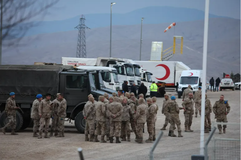
Hundreds of rescue workers have been deployed to a mine in eastern Turkey following a landslide on Tuesday 13 February 2024. The event happened when a spoil heap from the open-pit gold mine collapsed, leading several hundred tonnes of cyanide-laced soil to flow down into the mine site. Nine workers are reported to still be trapped within the mine, five within a shipping container, one inside a truck, and three in another vehicle. Concerns have been raised that cyanide from the mine may enter the Euphrates River, which runs close to the mine in the İliç District of Erzincan Province, then though Syria and Iraq before entering the Persian Gulf. Authorities in Turkey report damming a stream which flows from the mine to the Euphrates, and carrying out ongoing monitoring of the river.

Military personnel near the site of a gold mine hit by a landslide in Erzincan, Turkey. Ugur Yildirim/Getty Images.

The incident happened at the Çöpler Mine, which is operated by Anagold Madencilik, a subsidiary of the American SSR Mining. The mine has previously faced calls for its closure over an apparently poor safety record, following a cyanide leak in 2020, when the Euphrates was affected. On that occasion the mine was fined 16.5 million Turkish lire (US$537 000), but allowed to resume operating in 2022, despite objections from a range of organisations, including the Union of Chambers of Turkish Engineers and Architects, which includes the Chamber of Mining Engineers. Operations at the mine have been suspended pending an investigation. Four members of staff, including the pit's field manager, have been arrested as part of the investigation.

See also...

Friday, 8 September 2023

At least fourteen people dead as Storm Daniel sweeps across Greece, Turkey, and Bulgaria.

At least nine people have died, and several more are missing, after Storm Daniel swept across Greece, Turkey, & Bulgaria on Monday 4 and Tuesday 5 April 2023. In Greece a man died when a wall collapsed onto him in Volos on the Pagasetic Gulf, on Monday 4 September, and another man was killed in a vehicle-related incident, while on Wednesday 6 September the body of an elderly woman who was missing was found close to the city, having apparently drowned in the storm. Another four people are still missing in Greece. Considerable damage to infrastructure has occurred, and about a hundred people were evacuated from affected areas.

A collapsed bridge at Kala Nera on the western Pelion Peninsula. Stamos Prousalis/Reuters.

In Turkey at least two people have died in flooding in Istanbul and dozens have had to be rescued as floodwaters covered two neighbourhoods of the city, while in Kirklareli Province, close to the border with Bulgaria, five tourists are known to have died when a flash flood hit a campsite at which they were staying, and another one is still missing. Across the border in Bulgaria, four people are known to have died and three more are still missing after flooding hit the Black Sea coastal region.

Flood damage at Arnavutköy in Istanbul Province, Turkey. Ugur Yildirim/Getty Images.

Most storms form due to heating of air over the sea. As the air is heated the the air pressure drops and the air rises, causing new air to rush in from outside the forming storm zone. If this zone is sufficiently large, then it will be influenced by the Coriolis Effect, which loosely speaking means the winds closer to the equator will be faster than those further away, causing the storm to rotate, clockwise in the northern hemisphere and anticlockwise in the southern hemisphere.

A caravan swept out to sea on Bulgaria's Black Sea coast. Sofia Globe.

Whilst the high winds associated these storms is extremely dangerous, the real danger from such storms is often the flooding. Each millibar drop in air pressure can lead to a 1 cm rise in sea level, and large storms can be accompanied by storm surges several meters high. This tends to be accompanied by high levels of rainfall, caused by water picked up by the storm while still at sea, which can lead to flooding, swollen rivers and landslides; which occur when waterlogged soils on hill slopes lose their cohesion and slump downwards, over whatever happens to be in their path.

Such storms are common in tropical regions, but less so on the more temperate Mediterranean. However, this summer much of the eastern Mediterranean has suffered a prolonged heat wave, with temperatures regularly exceeding 40°C, and heat related deaths recorded across much of southern Europe, as well as a series of wildfires which have swept across Greece and other countries as vegetation has dried out. These events have been caused by a combination of an anticyclone (high pressure system) which formed over the Sahara then migrated northwards, intensified by an El Niño system over the southern Pacific, which tends to drive temperatures upwards in the Northern Hemisphere, both of which are considered to have been intensified by global warming.

See also...

Follow Sciency Thoughts on Facebook.

Follow Sciency Thoughts on Twitter.