Saturday, 8 July 2017

Sinkhole swallows bus in Veracruz, Mexico.

A bus was swallowed by a giant sinkhole in the city of Veracruz, in the Mexican state of the same name, on Friday 7 July 2017.  Nobody was hurt during the incident, as the bus was parked when the sinkhole opened,  but due to its large size, and the fact that it appears to be growing, at least twenty four neighbouring houses have been evacuated. Tn properties in other parts of the city have also been evacuated due to concerns about further sinkholes opening up.

Bus trapped in a sinkhole in Veracruz, Mexico, on 7 July 2017. Mexico News Daily.

Sinkholes are generally caused by water eroding soft limestone or unconsolidated deposits from beneath, causing a hole that works its way upwards and eventually opening spectacularly at the surface. Where there are unconsolidated deposits at the surface they can infill from the sides, apparently swallowing objects at the surface, including people, without trace.

The city of Veracruz is prone to sinkholes as it is located on soft limestone which is easily eroded by water; this weeks sinkholes have appeared after heavy rainfall in the area, with 125 mm falling in five hours this morning. This situation is made worse by the high level of seismic activity in Mexico, with even small tremors capable of repositioning deposits so that previously unexposed limestone layers come into contact with flowing water. In March 2016 the River Atoyac, which flows near the city, disappeared temporarily after a large sinkhole opened in its riverbed, an incident which is thought to have been triggered by a small Earthquake.

See also...

http://sciencythoughts.blogspot.co.uk/2016/11/eruptions-on-mount-popocatepetl.htmlhttp://sciencythoughts.blogspot.co.uk/2016/08/landslides-kill-at-least-40-as-tropical.html
http://sciencythoughts.blogspot.co.uk/2016/06/eruption-on-mount-popocatepetl.htmlhttp://sciencythoughts.blogspot.co.uk/2016/06/magnitude-47-earthquake-off-coast-of.html
http://sciencythoughts.blogspot.co.uk/2016/04/eruption-on-mount-popocatepetl.htmlhttp://sciencythoughts.blogspot.co.uk/2015/10/eruption-on-mount-popocatepetl.html
Follow Sciency Thoughts on Facebook.

Asteroid 2017 MC1 passes the Earth.

Asteroid 2017 MC1 passed by the Earth at a distance of  967 600 km (2.52 times the average distance between the Earth and the Moon, or 0.65% of the average distance between the Earth and the Sun), at about 9.25 pm GMT on Friday 30 June 2017. There was no danger of the asteroid hitting us, though had it done so it would have presented only a minor threat. 2017 MC1 has an estimated equivalent diameter of 25-78 m (i.e. it is estimated that a spherical object with the same volume would be 25-78 m in diameter), and an object towards the upper end of this range would be expected to explode in an airburst (an explosion caused by superheating from friction with the Earth's atmosphere, which is greater than that caused by simply falling, due to the orbital momentum of the asteroid) in the atmosphere about 2 km above the ground, with an explosive force about 1150 times as large as that of the Hiroshima bomb; not large enough to cause long-lasting global problems, but fairly devastating for anyone directly underneath.

The calculated orbit of 2017 MC1. Minor Planet Center.

2017 MC1 was discovered on 20 June 2017 (10 days before its closest approach to the Earth) by the University of Hawaii's PANSTARRS telescope on Mount Haleakala on Maui. The designation 2017 MC1 implies that it was the 28th asteroid (asteroid C1) discovered in the second half of June 2017 (2017 M).

2017 MC1 has a 1656 day orbital period and an eccentric orbit tilted at an angle of 0.88° to the plane of the Solar System, which takes it from 0.95 AU from the Sun (i.e. 95% of he average distance at which the Earth orbits the Sun) to 4.53 AU from the Sun (i.e. 453% of the average distance at which the Earth orbits the Sun, and over three times the orbit of the planet Mars). It is therefore classed as an Apollo Group Asteroid (an asteroid that is on average further from the Sun than the Earth, but which does get closer). This means that close encounters between 2017 MC1 and the Earth are not particularly common, though the asteroid does occasionally pass close to Jupiter, with this last having happened in November 2014.

See also...

http://sciencythoughts.blogspot.co.uk/2017/06/asteroid-2017-mf-passes-earth.htmlhttp://sciencythoughts.blogspot.co.uk/2017/06/asteroid-2017-kw31-passes-earth.html
http://sciencythoughts.blogspot.co.uk/2017/06/comet-c2015-v2-johnson-approaches-earth.htmlhttp://sciencythoughts.blogspot.co.uk/2017/05/asteroid-2017-kh5-passes-earth.html
http://sciencythoughts.blogspot.co.uk/2017/05/asteroid-2017-ky4-passes-earth.htmlhttp://sciencythoughts.blogspot.co.uk/2017/05/asteroid-2017-jv1-passes-earth.html
Follow Sciency Thoughts on Facebook.

Eleven confirmed deaths in Japan landslides.

Eleven people have been confirmed dead and a further fourteen are missing following a series of landslides and flash floods in Fukuoka and Oita prefectures, on Kyūshū Island, Japan, this week. The events occurred after very high rainfall in the area, with 600 mm of rain falling in parts of Fukuoka between Wednesday 5 and Friday 7 July 2017, in the wake of Tropical Storm Nanmadol which swept across Japan earlier. Landslides are a common problem after severe weather events, as excess pore water pressure can overcome cohesion in soil and sediments, allowing them to flow like liquids. Approximately 90% of all landslides are caused by heavy rainfall. 

The aftermath of a flash flood in Asakura, Fukuoka Prefecture, on Thursday 6 July 2017. Kimimasa Mayama/EPA.

Tropical Storm Nanmadol developed over the West Philippine Sea as a tropical depression on 1 July, sweeping northeast and growing in strength until it hit the Japanese coast near Nagasaki on 4 July, when it has wind speeds slightly below the threshold at which it could be considered a typhoon (sustained winds in excess of 119 kilometres per hour).

Tropical storms are caused by solar energy heating the air above the oceans, which causes the air to rise leading to an inrush of air. If this happens over a large enough area the in rushing air will start to circulate, as the rotation of the Earth causes the winds closer to the equator to move eastwards compared to those further away (the Coriolis Effect). This leads to tropical storms rotating clockwise in the southern hemisphere and anticlockwise in the northern hemisphere.These storms tend to grow in strength as they move across the ocean and lose it as they pass over land (this is not completely true: many tropical storms peter out without reaching land due to wider atmospheric patterns), since the land tends to absorb solar energy while the sea reflects it.

The low pressure above tropical storms causes water to rise there by ~1 cm for every millibar drop in pressure, leading to a storm surge that can overwhelm low-lying coastal areas, while at the same time the heat leads to high levels of evaporation from the sea - and subsequently high levels of rainfall. This can cause additional flooding on land, as well as landslides, which are are a common problem after severe weather events, as excess pore water pressure can overcome cohesion in soil and sediments, allowing them to flow like liquids. Approximately 90% of all landslides are caused by heavy rainfall.

See also...

http://sciencythoughts.blogspot.co.uk/2016/10/eruption-on-mount-aso-kyushu-island.htmlhttp://sciencythoughts.blogspot.co.uk/2016/06/magnitude-45-earthquake-in-kumamoto.html
http://sciencythoughts.blogspot.co.uk/2016/04/thousands-evacuated-and-at-least-nine.htmlhttp://sciencythoughts.blogspot.co.uk/2016/02/eruption-on-sakurajima-volcano-japan.html
http://sciencythoughts.blogspot.co.uk/2014/08/magnitude-61-earthquake-off-coast-of.htmlhttp://sciencythoughts.blogspot.co.uk/2014/01/small-eruption-in-aso-caldera-japan.html
Follow Sciency Thoughts on Facebook.

Friday, 7 July 2017

Nagiella occultalis: A new cryptic species of Pyraloid Moth from China.

Pyraloid Moths of the Subfamily Spilomelinae are diverse and global in distribution, with over 3300 species in over 300 genera. The genus Nagiella currently contains three species, with large widespread populations found across Burma, China, Japan and Malaysia. However, these are small and dull coloured Moths, and are not well studied, making it possible that these widely distributed species may in fact represent clusters of similar appearing species that have not yet been differentiated.

In a paper published in the journal ZooKeys on 8 June 2017, Misbah Ullah, Zhaofu Yang, Pingping Qiao and Yalin Zhang of the Key laboratory of Plant Protection Resources and Pest Management at Northwest A&F University describe new species of Nagiella from Shaanxi and Hubei Provinces, discovered as part of a study in which specimens apparently of the species Nagiella quadrimaculalis were collected from across a wide area of China then DNA sequenced to determine if that they were in fact the same species.

The new species is named Nagiella occultalis, meaning ‘cryptic’. It is described from three male specimens, two collected from Taibai Mountain in Shaanxi Province and one from Changleping town in Hubei Province. These are essentially similar to Nagiella quadrimaculalis, being yellowish brown to black with white spots on the wings, and with a forewing length of 15-16 mm, but were determined to be a separate language by DNA analysis. 

Male specimen of Nagiella occultalis in dorsal view. Ullah et al. (2017).

See also....

http://sciencythoughts.blogspot.co.uk/2017/06/boalda-poguei-new-species-of-owlet-moth.htmlhttp://sciencythoughts.blogspot.co.uk/2017/05/neopalpa-donaldtrumpi-new-species-of.html
http://sciencythoughts.blogspot.co.uk/2016/03/teinotarsina-aurantiaca-new-species-of.htmlhttp://sciencythoughts.blogspot.co.uk/2015/12/micropterix-gaudiella-new-species-of.html
http://sciencythoughts.blogspot.co.uk/2015/02/a-new-species-of-grass-moth-from-tibet.htmlhttp://sciencythoughts.blogspot.co.uk/2014/11/two-new-species-of-tortrix-moths-from.html
Follow Sciency Thoughts on Facebook.

Thursday, 6 July 2017

Magnitude 6.5 Earthquake under Layte Island, The Philippines, killsat least two.

The United States Geological Survey recorded a Magnitude 6.5 Earthquake at a depth of 6.5 km,eight kilometers to the west of the town of Jaro on Leyte Island, The Philippines, slightly after 4.00 pm local time (slightly after 4.00 pm GMT), on Thursday 6 July 2017. At least two people have died following this event, one in a landslide triggered by the Earthquake in Ormoc, and another in a shopping center that collapsed in Kananga; a number of other people are believed to be trapped within the building, and it is feared that the death tole may rise.

Cars trapped beneath a collapsed shopping centre in Kananga, Leyte, on 6 July 2017. ABS.CBN.

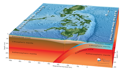
The geology of the Philippines is complex, with the majority of the islands located on the east of the Sunda Plate. To the east of this lies the Philippine Sea plate, which is being subducted beneath the Sunda Plate (a breakaway part of the Eurasian Plate); further east, in the Mariana Islands, the Pacific Plate is being subducted beneath the Philippine Sea Plate. This is not a smooth process, and the rocks of the tectonic plates frequently stick together before eventually being broken apart by the rising pressure, leading to Earthquakes in the process. Material from the subducting Philippine Plate is heated by the temperature of the Earth's interior, causing lighter minerals to melt and the resultant magma to rise through the overlying Sunda Plate, fueling the volcanoes of the Philippines.
 
 Subduction beneath the Philippines. Yves Descatoire/Singapore Earth Observatory.
 
Witness accounts of Earthquakes can help geologists to understand these events, and the structures that cause them. The international non-profit organisation Earthquake Report is interested in hearing from people who may have felt this event; if you felt this quake then you can report it to Earthquake Report here.
 
The approximate location of the 6 July 2017 Leyte Earthquake. USGS.
 
See also...
 
http://sciencythoughts.blogspot.co.uk/2017/05/magnitude-69-earthquake-off-south-coast.htmlhttp://sciencythoughts.blogspot.co.uk/2017/04/magnitude-53-earthquake-off-northeast.html
http://sciencythoughts.blogspot.co.uk/2017/04/student-killed-in-landslide-on-luzon.htmlhttp://sciencythoughts.blogspot.co.uk/2017/02/magnitude-65-earthquake-off-north-coast.html
http://sciencythoughts.blogspot.co.uk/2017/01/landslide-kills-78-year-old-man-on-cebu.htmlhttp://sciencythoughts.blogspot.co.uk/2016/09/magnitude-59-earthquake-on-mindanao.html
Follow Sciency Thoughts on Facebook.

Saturday, 1 July 2017

Sinkhole swallows car in St Loius, Missouri.

A driver returning to his car after visiting a gym in the Downtown area of St Louis, Missouri on Thursday 29 June 2017 was shocked to discover the vehicle had been swallowed by a sinkhole measuring six meters across and about seven meters deep. Nobody was hurt in the incident, but it is unclear at this time whether the vehicle will be salvageable.

Vehicle trapped in a sinkhole in St Louis, Missouri, on Thursday 29 June 2017. Christian Gooden/St. Louis Post-Dispatch.

Sinkholes are generally caused by water eroding soft limestone or unconsolidated deposits from beneath, causing a hole that works its way upwards and eventually opening spectacularly at the surface. Where there are unconsolidated deposits at the surface they can infill from the sides, apparently swallowing objects at the surface, including people, without trace.

However in this occasion the sinkhole is believed to have been caused by a ruptured water main, which washed away unconsolidated sediments beneath the road, creating a void into which the vehicle collapsed.

See also...

http://sciencythoughts.blogspot.co.uk/2015/12/stroms-and-floods-kill-at-least-43.html
http://sciencythoughts.blogspot.co.uk/2017/03/hundreds-of-homes-damage-as-storms.html

http://sciencythoughts.blogspot.co.uk/2015/05/giant-sinkholes-appear-at-missouri-golf.html
http://sciencythoughts.blogspot.co.uk/2015/10/magnitude-34-earthquake-in-ripley.html
http://sciencythoughts.blogspot.co.uk/2014/07/magnitude-28-earthquake-in-dunklin.html
http://sciencythoughts.blogspot.co.uk/2015/04/magnitude-36-earthquake-in-pemiscot.html

Follow Sciency Thoughts on Facebook.

German tourist found dead on Sumatran volacno.

The body of a German tourist missing since Wednesday 21 June 2017 has been found close to a waterfall on Mount Sibayak, North Sumatra, on Thursday 29 June. Klaus Wolter, a resident of Singapore, had set off to climb the volcano, a popular tourist attraction, but failed to return, prompting an eight day search by Indonesian search and rescue teams. His body has been identified by his wife.

Indonesian rescue workers recovering the body of a German tourist from Mount Sibayak, North Sumatra, on Friday 30 June 2017. AFP.

Mount Sibayak is a 2200 m stratovolcano (cone shaped volcano made up of layers of ash and lava) located close to the town of Berastagi in North Sumatra. It has not erupted since 1881, but is still considered an active volcano due to its numerous steam vents and hot springs. The volcano is considered an easy climb, with a picturesque, if somewhat acidic, crater lake.

The Indo-Australian Plate, which underlies the Indian Ocean to the west of Sumatra, is being subducted beneath the Sunda Plate, a breakaway part of the Eurasian Plate which underlies Sumatra and neighbouring Java, along the Sunda Trench, passing under Sumatra, where friction between the two plates can cause Earthquakes. As the Indo-Australian Plate sinks further into the Earth it is partially melted and some of the melted material rises through the overlying Sunda Plate as magma, fuelling the volcanoes of Sumatra.

 The Subduction zone beneath Sumatra. NASA/Earth Observatory.

This does not happen at a 90° angle, as occurs in the subduction zones along the western margins of North and South America, but at a steeply oblique angle. This means that as well as the subduction of the Indo-Australian plate beneath the Sunda, the two plates are also moving past one-another. This causes rifting within the plates, as parts of each plate become stuck to the other, and are dragged along in the opposing plate's direction. The most obvious example of this is the Sumatran Fault, which runs the length of Sumatra, with the two halves of the island moving independently of one-another. This fault is the cause of most of the quakes on the island, and most of the island's volcanoes lie on it.

  The movement of the tectonic plates around Sumatra. NASA/Earth Observatory.

See also...

http://sciencythoughts.blogspot.co.uk/2017/02/eruption-on-mount-krakatau.htmlhttp://sciencythoughts.blogspot.co.uk/2017/01/magnitude-57-earthquake-in-north-sumatra.html
http://sciencythoughts.blogspot.co.uk/2016/12/magnitude-65-earthquake-on-north-coast.htmlhttp://sciencythoughts.blogspot.co.uk/2016/07/magnitude-51-earthquake-beneath-west.html
http://sciencythoughts.blogspot.co.uk/2016/05/pyroclastic-flow-kills-at-least-seven.htmlhttp://sciencythoughts.blogspot.co.uk/2016/05/seventeen-students-confirmed-dead-after.html
Follow Sciency Thoughts on Facebook.