
The United States Geological Survey recorded a Magnitude 4.9 Earthquake at a depth of 43.2 km in Acamyo Province in the Cusco Region of Peru, at about 9.35 pm local time on Saturday 27 September 2014 (about 2.35 am on Sunday 28 September GMT). The quake was felt across much of the region, and is reported to have caused the collapse of 45 homes and an eighteenth century church in the village of Misca, and led to the deaths of four adults and four children in the village.

Peru is on the west coast of South America and the western margin of the
South American Plate, close to where the Nazca Plate, which underlies
part of the east Pacific, is being subducted along the Peru-Chile
Trench. The Nazca Plate passes under the South American Plate as it
sinks into the Earth, this is not a smooth process and the plates
repeatedly stick together then break apart as the pressure builds up,
causing Earthquakes. As the Nazca Plate sinks further it is partially
melted by the friction and the heat of the Earth's interior. Some of
this melted material then rises through the overlying South American
Plate, fuelling the volcanoes of Peru and neighbouring countries.

See also...
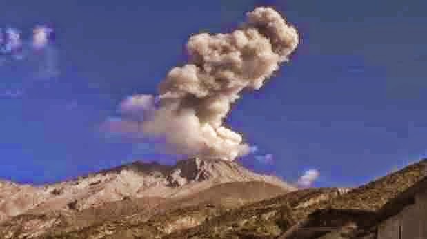 Eruption on Mount Urbinas. Mount Urbinas, a small but highly active volcano in the southern
Peruvian Andes, generally considered to be Peru's most active volcano,
erupted at 7.42 am local time (1.42 pm GMT) on Monday 31 March 2014...
Eruption on Mount Urbinas. Mount Urbinas, a small but highly active volcano in the southern
Peruvian Andes, generally considered to be Peru's most active volcano,
erupted at 7.42 am local time (1.42 pm GMT) on Monday 31 March 2014...
 Magnitude 6.3 Earthquake on the Peruvian coast. The United States Geological Survey
recorded a Magnitude 6.3 Earthquake at a depth of 9.8 km, on the coast
of Sechura Province in northern Peru, roughly 6...
Magnitude 6.3 Earthquake on the Peruvian coast. The United States Geological Survey
recorded a Magnitude 6.3 Earthquake at a depth of 9.8 km, on the coast
of Sechura Province in northern Peru, roughly 6...
 Magnitude 4.7 Earthquake in Coronel Portillo Province, Peru. The United States Geological Survey
recorded a Magnitude 4.7 Earthquake at a depth of 17.1 km in
eastern Coronel Portillo Province, close to the border with Brazil, at...
Magnitude 4.7 Earthquake in Coronel Portillo Province, Peru. The United States Geological Survey
recorded a Magnitude 4.7 Earthquake at a depth of 17.1 km in
eastern Coronel Portillo Province, close to the border with Brazil, at...
The subduction of the Nazca Plate beneath the South American Plate, and how it causes Earthquakes and volcanoes. Pacific Earthquake Engineering Research Center.
See also...
Eruption on Mount Urbinas. Mount Urbinas, a small but highly active volcano in the southern
Peruvian Andes, generally considered to be Peru's most active volcano,
erupted at 7.42 am local time (1.42 pm GMT) on Monday 31 March 2014... Magnitude 6.3 Earthquake on the Peruvian coast. The United States Geological Survey
recorded a Magnitude 6.3 Earthquake at a depth of 9.8 km, on the coast
of Sechura Province in northern Peru, roughly 6... Magnitude 4.7 Earthquake in Coronel Portillo Province, Peru. The United States Geological Survey
recorded a Magnitude 4.7 Earthquake at a depth of 17.1 km in
eastern Coronel Portillo Province, close to the border with Brazil, at...
Follow Sciency Thoughts on Facebook.