Showing posts with label Antarctic Plate. Show all posts

Sunday, 24 January 2021

Magnitude 6.9 Earthquake in the South Shetland Islands.

The United States Geological Survey recorded a Magnitude 6.9 Earthquake at a depth of 9.6 km roughly 50 km to the south of Elephant Island in the South Shetland Islands, slightly after 8.35 pm local time (slightly after 11.35 pm GMT) on Saturday 23 January 2021. This is a large Earthquake, and potentially very dangerous in a less remote area; in this case there are no reports of any damage or injuries associated with the event, although people have reported feeling it at the Chilean Great Wall Station on King George Island.

 
The approximate location of the 23 January 2021 South Shetland Islands Earthquake. USGS.

The South Shetland Islands lie on the boundary between the Antarctic Plate and the South Shetland Plate, a small tectonic plate more-or-less surrounded by the Antarctic Plate, and being subducted beneath it from the southeast in the South Shetland Trench, with the majority of the South Shetlands forming an island arc above the subduction zone. Elephant and Clarence Islands lie away from the rest of the South Shetland Islands, on the boundary between the South Shetland Plate and the Scotia Plate, though they probably share a common origin with the other islands. The margin between the South Shetland Plate and the Scotia Plate is a Transform Margin, where the two plates move past one-another, the Scotia Plate moving east with regard to the South Sandwich Island Plate. This is not a smooth process, the plates often sticking, leading to a pressure build-up, then an earthquake (or series of earthquakes) as the rocks give way and the pressure is released.

 
The Scotia Plate (yellow), showing its margins. Boundary with the South Shetland Plate (pink) is in the southwest. Carlton College.

See also...


Follow Sciency Thoughts on Facebook.

Follow Sciency Thoughts on Twitter.


Wednesday, 3 February 2016

Scientists observe eruption on Heard Island.

A group of scientists from the Australian Commonwealth Scientific and Industrial Research Organisation (CSIRO) have observed am eruption on Heard Island, a remote Australian territory in the southern Indian Ocean, while on a voyage to the remote Kerguelen Plateau in the Research Vessel Investigator. Eruptions on the island are thought to be quite common, but due to the remoteness of the location (nobody has set foot on the island for around 30 years) they tend not to be recorded unless they are large enough to be seen in satellite images.

A small volcanic plume emerging from the summit of Mawson Peak on Heard Island. Peter Harms/CSIRO.

Heard Island is part of the Kerguelen Plateau, a sunken microcontinent roughly 3000 km to the southwest of Australia, which is believed to have been part of the ancient supercontinent of Gondwana prior to its breakup. Most of the microcontinent is now an average of 600 m below the sea surface but the volcanic Kerguelen Islands plus the Heard and MacDonald Islands still rise above sealevel. Volcanism on the plateau began during the breakup of Gondwana, with the formation of the Kerguelen Hotspot between the landmasses that went on to become India and Antarctica, and is still going on to a minor extent on Heard and MacDonald Islands. The area is thought to have been covered with Conifer forests during the Cretaceous, and the islands still host unique floral communities.

 The approximate location of Heard Island. Google Maps.

The scientists were in the area primarily to study underwater plumes associated with submarine volcanoes on the Kerguelen Plateau, of which about fifty have been observed to date, and were not confident of seeing the islands of the region at all, due to constant heavy cloud cover in the region, but in the event have witnessed plumes over both Heard and MacDonald islands, as well as lava flowing over the surface of a glacier on Heard Island.

Video footage of eruptive activity on Heard Island shot by scientists on the RV Investigator. Institute for Marine and Antarctic Studies.

See also...

http://sciencythoughts.blogspot.co.uk/2015/11/eruption-on-heard-island.htmlEruption on Heard Island.                                A United States Air Force satellite detected an ash plume above Heard Island, an uninhabited volcanic island roughly in the Southern Ocean, midway between Madagascar, Antarctica and Australia on Friday 30...
http://sciencythoughts.blogspot.co.uk/2012/11/volcanic-activity-on-heard-island.htmlVolcanic activity on Heard Island.              Heard Island is a remote volcanic island on the Kerguelen Plateau in the southern Indian Ocean. It is made up of two volcanoes, the larger Big Ben to the southeast and the smaller Mount Dixon...
Follow Sciency Thoughts on Facebook.

Thursday, 5 November 2015

Eruption on Heard Island.

A United States Air Force satellite detected an ash plume above Heard Island, an uninhabited volcanic island roughly in the Southern Ocean, midway between Madagascar, Antarctica and Australia on Friday 30 October 2015. This is the first activity detected on the island since 2013, though the island is so remote that activity in the intervening time cannot be ruled out.

The approximate location of Heard Island. Google Maps.

Heard Island is part of the Kerguelen Plateau, a sunken microcontinent roughly 3000 km to the southwest of Australia, which is believed to have been part of the ancient supercontinent of Gondwana prior to its breakup. Most of the microcontinent is now an average of 600 m below the sea surface but the volcanic Kerguelen Islands plus the Heard and MacDonald Islands still rise above sealevel. Volcanism on the plateau began during the breakup of Gondwana, with the formation of the Kerguelen Hotspot between the landmasses that went on to become India and Antarctica, and is still going on to a minor extent on Heard and MacDonald Islands. The area is thought to have been covered with Conifer forests during the Cretaceous, and the islands still host unique floral communities.

Plate reconstructions of the southern Indian Ocean region. Red stars = possible reconstructed positions of the Kerguelen Hotspot; those labeled “K” assume that the Kerguelen archipelago is the current location of the Kerguelen hotspot, and those labeled “H” assume that Heard Island is the hotspot’s current location. Black shading = magmatism associated with the Kerguelen Hotspot, diamonds = lamprophyres (labeled with “L” in 110 Ma panel) as they have appeared through geologic time. Dashed line = a possible northern boundary for Greater India. IND = India, ANT = Antarctica, AUS = Australia. (A), (B) Seafloor spreading initiated at ~133 Ma between Western Australia and Greater India and at ~125 Ma between Australia and Antarctica. This model assumes breakup between India and Antarctica at ~133 Ma, although the timing of this event is not well known. The Bunbury Basalt (BB) of Southwest Australia erupted close to these breakup events in both time and space. Continental portions of Elan Bank (EB) and the Southern Kerguelen Plateau (unknown dimensions) remained attached to Greater India at these times. The Naturaliste Plateau (NP) also contains continental crust. (C), (D) Seafloor spreading continued between India, Antarctica, and Australia. The initial massive pulse of Kerguelen magmatism created the Southern Kerguelen Plateau (SKP), the Rajmahal Traps (RAJ), and Indian/Antarctic lamprophyres (L) from ~120 to ~110 Ma (Fig. F3, p. 38) and may be linked to breakup and separation between Elan Bank and Greater India. The Central Kerguelen Plateau (CKP) formed between ~105 and ~100 Ma and Broken Ridge (BR) between ~100 and ~95 Ma (Fig. F3, p. 38). Igneous basement of the Wallaby Plateau (WP) is not well characterized geochemically and has not been dated, but its age is inferred to lie between ~120 and ~100 Ma. (E), (F) The hotspot generated the Ninetyeast Ridge (NER) and Skiff Bank (SB) as India continued its northward drift relative to Antarctica. (G), (H) At ~40 Ma, seafloor spreading commenced between the Central Kerguelen Plateau and Broken Ridge. The hotspot generated the Northern Kerguelen Plateau (NKP), and, since 40 Ma, as Broken Ridge and the Kerguelen Plateau have continued to separate, has produced the Kerguelen Archipelago, Heard and McDonald Islands, and the chain of volcanoes between Kerguelen and Heard. Frey et al. (2003).


See also...

Heard Island is a remote volcanic island on the Kerguelen Plateau in the southern Indian Ocean. It is made up of two volcanoes, the larger Big Ben to the southeast and the smaller Mount Dixon to the...


Mount Siple is one of the world's most remote volcanoes, located on Siple Island, off the coast of Marie Byrd Land, Antarctica. It is a shield volcano (volcano with a fairly flat profile made up mostly...


On Sunday 15 January 2012 at approximately 9.40 am local time (1.40 pm GMT) Elephant Island in the South Shetland Islands was shaken by an Earthquake measuring 6.6 on the Richter Scale at a depth of approximately 10 km, according to the United States Geological Survey. This was followed by a...


Follow Sciency Thoughts on Facebook.

Saturday, 28 January 2012

The Penguins of Africa.

A single species of Penguin, Spheniscus demersus, or the Blackfooted Penguin, lives in Southern Africa today, though two species, Nucleornis insolitus and Inguza predemersus are known to have lived there in the Early Pliocene. It has generally been assumed that the modern Penguins are descendants of the fossil penguins, though since they are also clearly closely related to other Penguins of the genus Spheniscus, which live in South America and the Galapagos, it is difficult to say what the exact relationship is.

Issue 279 of the Proceedings Of The Royal Society B contains a paper by Daniel Ksepka of the Department of Marine, Earth and Atmospheric Sciences at North Carolina State University and the Department of Zoology at the University of Cape Town and Daniel Thomas of the Department of Paleontology at North Carolina Museum of Natural Sciences in which they describe the results of a thorough investigation into South Africa's Penguins and the conclusions derived from this.
Reconstruction of the Pliocene Penguin Inguza predemersus (right) with a modern Blackfooted Penguin (left) for scale. From Ksepska and Thomas (2012).


Ksepska and Thomas examined over 200 fossil Penguins from the Iziko South African Museum collections, and compared them to recent and fossil penguins from South Africa and elsewhere. The came to the conclusion that modern Blackfooted Penguins are closely related to the Chinstrap Penguins of South America and the Galapagos, but not closely related to either of the fossil Penguins, and certainly not descended from either. Nor are the two extinct forms closely related.

This means that Penguins have invaded Africa on at least three separate occasions, something that Ksepska and Thomas examined next. Penguins appear first in the fossil record of New Zealand, but by the end of the Eocene are widespread in Antarctia, Australia and South America. They do not appear in Africa until the Early Pliocene, 30 million years later, and have never reached Madagascar of the Northern Hemisphere.

The inability of Penguins to colonize the Northern Hemisphere is the easiest to explain. Currents around the equator tend to flow away from it; in the Northern Hemisphere to the north and in the Southern Hemisphere to the south. There are also strong thermoclines to cross; water forms 'streams' within the ocean (such as the Gulf Stream) dependent on temperature, things flow easily within these streams, but it is hard to cross from one to the other. Similarly Madagascar is separated from Africa by the strong Agulhas Current, which sweeps away from Madagascar.

Africa can be reached from South America by the South Atlantic Current and the Antarctic Circumpolar Current, but these currents have not always flowed on their current paths. Prior to the Pliocene Antarctica and South America were still connected together; the Antarctic Peninsula was attached to the tip of Patagonia. This stopped the flow of the Antarctic Current, and trapped Penguins in the South Pacific. After the continents broke apart the Penguins were free to colonize the South Atlantic and soon reached Africa.

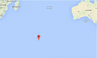
Map of the South Atlantic showing the prevalent currents and fronts. Dots show the location of modern Blackfooted Penguin colonies, and open stars locations where fossil Penguins have been found. From Ksepska and Thomas (2012).

Next Ksepska and Thomas looked at the extinction of the Pliocene Penguins. It is of course impossible to state the exact causes of such extinctions with absolute confidence, but this does not stop scientists from attempting to come up with plausible scenarios. During the Early Pliocene the sea-level was about 90 m higher than it is now. At the end of the Early Pliocene it dropped sharply, due to the increasing glaciation of Antarctica; another consequence of the separation of South America and Antarctica, which enabled the developing Circumpolar Current to isolate the southern continent in its own climatic zone, and caused the temperature to plummet. Ksepska and Thomas theorize that the Pliocene African Penguins may have been dependent on offshore islands as breeding grounds, and that either the falling waters left them vulnerable to African predators that they were unable to cope with, or that fluctuating sea levels associated with the changing climate left them unable to find safe nesting sites.


Monday, 16 January 2012

Series of Earthquakes in the South Shetland Islands.

On Sunday 15 January 2012 at approximately 9.40 am local time (1.40 pm GMT) Elephant Island in the South Shetland Islands was shaken by an Earthquake measuring 6.6 on the Richter Scale at a depth of approximately 10 km, according to the United States Geological Survey. This was followed by a magnitude 6.2 quake at a depth of about 14.2 km which took place slightly after 10.20 am local time (2.40 pm GMT), a magnitude 5.6 quake at a depth of 10 km a few minutes before midnight local time (4.00 am on 16 January GMT) and a magnitude 5.1 quake at a depth of roughly 15.7 km, about 50 km to the east, of the coast of Clarence Island. Given the remote location of the islands there are unlikely to have been any casualties, and no tsunami warning has been issued.

Map showing the location of the quakes (blue squares, larger squares are more powerful quakes). Red lines are plate margins. Palmer Station at the bottom of the map is a long term ecological research centre supported by the US National Science Foundation. Map from the United States Geological Survey.

The South Shetland Islands lie on the boundary between the Antarctic Plate and the South Shetland Plate, a small tectonic plate more-or-less surrounded by the Antarctic Plate, and being subducted beneath it from the southeast in the South Shetland Trench, with the majority of the South Shetlands forming an island arc above the subduction zone. Island arcs form above subduction zones when the plate being subducted is partially melted by the heat of the Earth's interior, causing hot liquid magma to rise up through the overlying plate forming volcanoes at the surface. The most famous volcano of the South Shetland Islands is Deception Island, A largely submerged active volcano with a crater that forms an open lagoon into which cruise ships can sail. The surrounding rim reaches 539 m above sea level at its highest point, is covered in glaciers and has a number of hot springs.


Elephant and Clarence Islands lie away from the rest of the South Shetland Islands, on the boundary between the South Shetland Plate and the Scotia Plate, though they probably share a common origin with the other islands. The margin between the South Shetland Plate and the Scotia Plate is a Transform Margin, where the two plates move past one-another, the Scotia Plate moving east with regard to the South Sandwich Island Plate. This is not a smooth process, the plates often sticking, leading to a pressure buildup, then an earthquake (or series of earthquakes) as the rocks give way and the pressure is released.

The Scotia Plate (yellow), showing its margins. Boundary with the South Shetland Plate (pink) is in the southwest. Map from Carlton College, Minnesota.

Thursday, 22 December 2011

A Titanosaur from the Antarctic.

Titanosaurs were the largest animals ever to roam on land; they were sauropod dinosaurs that survived to the end of the Cretaceous (most sauropods went extinct at the end of the Jurassic, certainly all non-Titanosaurian Sauropods were extinct by the Mid Cretaceous), and grew to sizes far in excess of their earlier relatives, which were big animals even by dinosaur standards. The biggest Titanosaur for which we can estimate a size, Argentinosaurus, grew up to 35 m in length and weighed 80-100 tonnes; it is quite possible that other Titanosaurs grew bigger, but most are only known from highly fragmented remains; in order to be fossilized efficiently an animal needs to be buried quickly, not easy for a creature as large as a Titanosaur.

Titanosaurs were first discovered in South America, where they seem to have originated and reached the peak of their diversity, and have subsequently been discovered in Africa, Europe, Asia, Australia and, most recently, North America. This month a team lead by Ignacio Cerda of Consejo Nacional de Investigaciones Científicas y Tecnológicas - INIBIOMA and the Museo de Geología y Paleontología at the Universidad Nacional del Comahue in Buenos Aeries published a paper in the German journal Naturwissenschaften in which they describe the discovery of a Titanosaur on James Ross Island, Antarctica.

The location of the Titanosaur find.

The discovery comprises only a part of a single vertebra; this is large and distinctive enough that it could not come from anything other than a Titanosaur, though Cerda et al. have not attempted any more detailed classification due to the limited nature of the material. The sedimentary beds in which the vertebra was found are thought to be of Upper Campanian age, between roughly 75 and 70 million years old.

The James Ross Island vertebra; (a & d) front view, (b & e) side view, (c & f) rear view.

Dinosaurs are not very well known from Antarctica, not so much because they were absent as because they are hard to find there now. Much of the continent is covered in snow and ice, and what is exposed has been scoured repeatedly by glaciation. Thus it is unsurprising that this is the first Titanosaur, and only the second Sauropod, found in Antarctica. Titanosaurs arose in South America and dispersed during the Early Cretaceous. Since they are known to have been present in Australia and New Zealand, areas that were still connected to Antarctica during the Early Cretaceous but not to any other land mass, then Titanosaurs must have been present in Antarctica at that time. It is possible that the new Titanosaur is descended from Titanosaurs that moved to Antarctica during this initial dispersal, but it is also possible that it is more closely related to the Titanosaurs present in South America during the Late Cretaceous, as South America and Antarctica were still connected till quite late in the Period (how late is still a matter of conjecture among geologists.

A reconstruction of the position of the continents during the Late Cretaceous.

See also An American Titanosaur and Dinosaurs on Sciency Thoughts YouTube.

Monday, 6 June 2011

The Puyehue-Cordón Caulle Volcanic Complex

The Puyehue-Cordón Caulle Volcanic Complex is in southern Chile, about 450 miles south of the capital Santiago, and about 20 miles west of the Argentine border. Chile has about 3000 volcanoes running from north to south along the whole length of the country, which about 80 are still periodically active. These occur as the Nazca Plate (part of the Pacific sea floor) is forced below the South American Plate; the South American plate is lifted up, forming the Andes Mountains, as the Pacific Plate is subducted into the Earth's mantle lighter minerals are melted and bubble up to the surface, creating a string of volcanoes throughout the Andes. The Andes are among the fastest growing mountains on Earth, and were where mountain orogeny (the growth of mountains) was first understood.


View Larger Map

The Puyehue-Cordón Caulle Volcanic Complex lies on the Liquiñe-Ofqui Fault, where the Nazca, South American and Antarctic Plates collide, an area of intense volcanic activity. The Puyehue-Cordón Caulle Volcanic Complex itself is between 200 000 and 300 000 when a shift in the fault shifted to the east and narrowed. A series of older volcanoes to the east all ceased activity at this time, and were replaced by younger larger volcanoes such as Puyehue-Cordón.

Technically Puyehue is a stratocone volcano, i.e. a classic cone-shaped volcano, whereas Cordón Cauelle is an adjacent volcanic fissure. The volcanic complex is very active, with a record of observed eruptions going back to 1759 when the first permanent European settlements in the area were established. There were nine eruptions during the twentieth century, including one in 1960 associated with the May 22 Valdivia earthquake, the most powerful earthquake ever recorded.

The complex began to erupt again on the 4th of June this year (2011), an eruption accompanied by a swarm of earthquakes and throwing an ash-cloud high into the air. It is not yet clear if this originates from the Puyehue stratocone or the Cordón Cauelle fissure, due to the remote location of the complex, within the Puyehue National Park and the fact that it is mid-winter in the southern hemisphere in June.

The Chilean government has responded by ordering the evacuation of around 3000 people from the area around the volcano, although it is unclear how many people have actually left; the raising livestock is an important part of the local economy and people are often reluctant to leave their animals.

The ash cloud has blown eastward over Argentina where two small airports servicing ski resorts among the extinct volcanoes of the eastern Liquiñe-Ofqui. Unlike British and Irish airlines, Argentine ones seem happy to accept that volcanic ash-clouds are dangerous to aircraft.


See also The Puyehue Eruption, Chile, 2011.
The Grímsvöten Volcano and
Volcanos on Sciency Thoughts YouTube