
Gathering data on the numbers and movements of far-ranging ocean Animals such as Cetaceans is notoriously difficult, which is unfortunate, as such Animals are considered to be key indicators of the condition of marine ecosystems, with current concerns about the long-term health of the marine environment making such data particularly crucial. The Marine StrategyFramework Directive requires European Union member states with coasts to monitor the biodiversity of their territorial waters in order to maintain the marine environment. However, this does not include dedicated Cetacean surveys, due to the complexity and expense of maintaining such programs. This leaves Cetacean surveys largely in the hands of citizen scientists and commercial organizations.
The highly charismatic nature of Whales and Dolphins makes them ideal for citizen science projects, with the public often keen to take a role in their conservation. Whale watching tours have become popular tourist activities in many parts of the world in recent decades, providing both a tool for educating the public about marine ecology and an excellent opportunity for scientific programs studying Whales to piggyback onto the commercial activity. Such programs have proven particularly good for gathering long-term data on Whales within areas where tours are carried out. Whale-watching tours are therefore a cost-effective tool for monitoring Whale populations, particularly in areas where funding is limited or unavailable. Successful examples include the ORCA Survey Network operating in UK waters, the Fixed Line Transect Mediterranean monitoring Network, which works from European Atlantic and Mediterranean ferries, the CETUS project, which operates from cargo boats out of Macaronesia (the Azores, Madeira, the Canaries, and the Cape Verde islands) and mainland Portugal, and the Kakila database, which gathers data from Whale watching tours in the Caribbean. Data gathered from such sources has led to numerous publications on the distribution, movements, and habitat preferences of Cetaceans.
The Azores Islands are located in the North Atlantic Ocean at 36-41° North and 24-32° West. The archipelago is composed of nine volcanic islands organised into three groups separated by deep waters (i.e. deeper than 2000 m): the Western (Flores and Corvo), Central (Faial, Pico, Graciosa and Terceira) and Eastern groups (São Miguel and Santa Maria). The archipelago presents a well-defined oceanographic seasonality: March is usually the coldest month (average sea surface temperature 15°C), while the highest temperatures are generally reached in September (average sea surface temperature 25°C). The spring bloom is noticeable each year by the increase in chlorophyll concentrations, which drastically drop to oligotrophic conditions during summer.
The people of the Azores have been linked to Cetaceans since the islands were first colonised in the fifteenth century, when early settlers are known to have harvested Whales stranded on beaches or found dead at sea. In the mid eighteenth century, whalers from North America began to visit the islands in pursuit of Sperm Whales, Physeter macrocephalus, often recruiting local people as crew for their vessels. The Azoreans learned the techniques used by the Americans, and adapted them to their own needs, replacing spotters mounted high upon ships with spotters at high points on land, and using these to guide small boats towards sited Whales in the same way.
Over time the oil for which Sperm Whales was hunted was replaced by oil from other sources, making Whaling less profitable, and the practice began to die out in the 1960s. In 1982, Portugal ratified the Moratorium of theInternational Whaling Commission, and in 1986 Whaling was officially banned in all Portuguese territories, including the Azores, where the last two Sperm Wales were killed in 1987.
The whaling industry provided the first accurate data on Whales collected in the Azores, with whalers collecting data on changes in the distribution of Whales over time, the first accurate descriptions of the Animals, and even the first records of their eating giant Cephalopods. In 1987 the government of the Azores, with support from the European Union, invited the International Fund for Animal Welfare to carry out a feasibility study on the potential for developing a Whale-watching industry in the Islands. The first tours were carried out from Pico Island in 1989, and rapidly became popular with tourists. Some the earliest recruits to the new business were former lookouts from the Whaling industry, and they were soon followed by former whalers, who worked as skippers on the new boats, brining with them their expertise in the ecology and behaviour of the Whales. In 1993 Whale-watching tours also began from São Miguel Island, with tours later starting from Faial and Terciera islands.
To date, 28 species of Whales and Dolphins have been observed around the Azores, making the islands one of the most popular Whale-watching destinations in the world. From the outset, the Whale-watching industry in the Azores was built on an ecotourism model, with regulations developed through collaboration between the tour operators, the scientific community, and the government of the Azores. The first Bienal das Baleias conference was held in Lajes do Pico in October 1998, with the various groups involved seeking to come to a consensus on further developing an ecologically friendly industry. As a consequence of this, legislation was introduced in 1999, which required the mandatory collecting of data on Whales by the tour boats, although this proved to be highly impractical, and was quickly dropped, although all parties involved agreed that a system of gathering this data was needed, both to develop the Whale-watching industry and to further the study and conservation of the Whales.
The MONICET project grew out of a discussion at the 2006 Bienal das Baleias conference, with a scientific consortium working with three Whale-watching companies to develop a methodology for collecting data in a scientifically usable manner, and a remit to develop a database to store this data, all funded by a grant from the Azores government.
In a paper published in the Biodiversity Data Journal on 8 August 2023, Laura González García of the Institute of Marine Sciences at the University of the Azores, Marc Fernández of the Marine and Environmental Sciences Centre of the Agência Regional para o Desenvolvimento da Investigação Tecnologia e Inovação, and José Azevedo, also of the Institute of Marine Sciences at the University of the Azores, describe the methodology used by the MONICET project, the data gathered by that project so far, and ways in which this data might be used by researchers outside the Azores.
González García et al. describe eleven years of MONICET data, collected between 2009 and 2020, and provided by 11 of the 23 Whale watching companies active in the Azore, operating out of four of the nine volcanic islands which make up the Azores (Azores Experiences and Peter Whale Watch from Faial Island; Aqua Açores and Espaço Talassa from Pico Island; Futurismo Azores Adventures, Picos de Aventura, Terra Azul, Terra do Pico and Sea Colors from São Miguel Island and Atlantiangra, Ocean Emotion and Picos de Aventura from Terceira Island). Not every company reported data every year; participitation in the project is voluntary, and data will always be accepted from any company wishing to participate. In the first year of the project only three companies reported data, while the greatest number was reached in 2019, when nine companies reported.
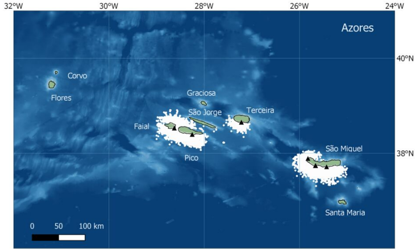
MONICET uses a collaborative platform to collect and disseminate data on Cetacean sightings and movements, as well as photo images used for Whale identification. The data is collected on a voluntary basis, and is available to all interested persons, including the general public.
Whale-watching tours in the Azores typically last 2.5-3 hours, with most companies operating two tours per day, although some run three per day in the peak of the tourist season. Tours operate from São Miguel Island year-round, but from the other islands is more seasonal, typically running from May to September. In all cases, Whales are first spotted from land, with experienced spotters guiding boats to the Cetaceans. This typically results in at least one Whale encounter per trip, with boats moving to the Whales then slowing down for periods of observation.
The data used by MONICET is typically gathered by trained guides on board the boats (often trained biologists), who record the times at which the boats leave and return to their home ports, the location of the boats throughout their voyage (recorded with a GPS system), and the time, location, and species of any Whales encountered, as well as the number of Whales, their approximate age (adults, juveniles or calves), and behaviour, as well as other data about weather, sea conditions etc. Guides are provided with annual training on data collection by MONICET.

During the period recorded in González García et al.'s data, 37 000 sightings were recorded of 22 Cetacean and three Turtle species, including Minke Whale, Balaenoptera acutorostrata, Sei Whale, Balaenoptera borealis, Bryde's Whale, Balaenoptera edeni, Blue Whale, Balaenoptera musculus, Fin Whale, Balaenoptera physalus, Humpback Whale, Megaptera novaeangliae, Common Dolphin, Delphinus delphis, Short-finned Pilot Whale, Globicephala macrorhynchus, Long-finned Pilot Whale, Globicephala melas, Risso's Dolphin, Grampus griseus, Killer Whale, Orcinus orca, False Killer Whale, Pseudorca crassidens, Striped Dolphin, Stenella coeruleoalba, Atlantic Spotted Dolphin, Stenella frontalis, Bottlenose Dolphin, Tursiops truncatus, Pygmy Sperm Whale, Kogia breviceps, Sperm Whale, Physeter macrocephalus, North Atlantic Bottlenose Whale, Hyperoodon ampullatus, Sowerby's Beaked Whale, Mesoplodon bidens, Blainville's Beaked Whale, Mesoplodon densirostris, True's Beaked Whale, Mesoplodon mirus, and Cuvier's Beaked Whale, Ziphius cavirostris, as well as Loggerhead Turtle, Caretta caretta, Green Turtle, Chelonia mydas, and Leatherback Turtle, Dermochelys coriacea.
One problem noted by González García et al. is that the MONICET data tends to reflect the commercial preferences of the tourist industry. Thus spotters will guide boats towards more appealing Cetaceans, such as families of Sperm Whales or active pods of Dolphins, over Beaked or diving Whales which spend little time at the surface. The data set is presumed to be good, given the training and experience of the guides, but some caution needs to be applied to sightings of more elusive Whales, as these are less often seen, and spend less time at the surface where they can be identified.
Some types of Whale will alter their behaviour in response to the presence of boats; this is particularly true of Dolphins, which tend to break off other activities in order to investigate Human visitors. For this reason, the activity of Whales is recorded when the boats first arrive, although there is a danger that the Whales may already have been affected by the presence of earlier boats.

See also...


Follow Sciency Thoughts on Facebook.
Follow Sciency Thoughts on Twitter.


