Showing posts with label Azores Microplate. Show all posts

Sunday, 8 March 2020

Magnitude 5.2 Earthquake to the southeast of Madeira.

The Centre Seismologique Euro-Méditeranéen  recorded a Magnitude 5.2 Earthquake at a depth of 10 km to the southeast of Madeira Island, Portugal, slightly before 9.00 pm local time (GMT) on Friday 7 March 2020. There are no reports of any damage or casualties associated with this event, though it was felt across the Madeira Islands group, as well as in parts of the Canary Islands.
 
The approximate location of the 7 March 2020 Madeira Earthquake. USGS.
 
Madeira lies to the south of the Cape St. Vincent Ridge, which runs along the boundary between the African and European plates to the east of the Mid-Atlantic Ridge. This is currently an area of expansion, with the two plates moving apart along this part of the boundary and new seafloor being created by the upwelling of magma from the mantle and its extrusion as a new area of crustal material, the Azores Microplate. This is not a smooth process, and can lead to occasional Earthquakes.

Witness accounts of Earthquakes can help geologists to understand these events, and the structures that cause them. The international non-profit organisation Earthquake Report is interested in hearing from people who may have felt this event; if you felt this quake then you can report it to Earthquake Report here.

See also...

https://sciencythoughts.blogspot.com/2020/02/flights-to-and-from-canary-islands.htmlhttps://sciencythoughts.blogspot.com/2019/08/thousands-forces-to-flee-their-homes-as.html
https://sciencythoughts.blogspot.com/2017/10/series-of-earthquakes-beneath-canary.htmlhttps://sciencythoughts.blogspot.com/2014/05/magnitude-42-earthquake-on-cape-st.html
https://sciencythoughts.blogspot.com/2013/12/magnitude-54-earthquake-off-coast-of-el.htmlhttps://sciencythoughts.blogspot.com/2013/08/the-floating-stones-of-el-hierro.html
Follow Sciency Thoughts on Facebook.

Monday, 12 May 2014

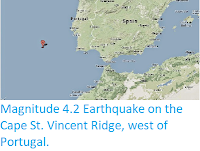
Magnitude 4.2 Earthquake on the Cape St. Vincent Ridge, west of Portugal.

The United States Geological Survey has reported a Magnitude 4.2 Earthquake at a depth of 15 km on the Cape St. Vincent Ridge, about 300 km to the west of the coast of southern Portugal, slightly after 1.45 pm GMT on Sunday 11 May 2014. While this is a moderately large quake it occurred a long way offshore in an area where it was unlikely to cause a tsunami, so there is no danger from this event, and it is highly unlikely that it was felt by anyone.

The approximate location of the 11 May 2014 Cape St. Vincent Earthquake. Google Maps.

The Cape St. Vincent Ridge runs along the boundary between the African and European plates to the east of the Mid-Atlantic Ridge. This is currently an area of expansion, with the two plates moving apart along this part of the boundary and new seafloor being created by the upwelling of magma from the mantle and its extrusion as a new area of crustal material, the Azores Microplate. This is not a smooth process, and can lead to occasional Earthquakes.

See also...


The United States Geological Survey recorded a Magnitude 5.4 Earthquake at a depth of 22.8 km roughly 31 km to the northwest of the island of El Hierro in the Canaries, slightly after 5.45 pm local...


When volcanic activity began off the south coast of El Hierro, in the Canary Islands, in October 2010, it led to the production of large plumes of pumice-like rocks that floated on the surface of the ocean, producing a distinctive volcanic 'stain'. Pumice is a volcanic rock which contains large vesicles (sealed, gas filled cavities) which cause it to float on the water, which is formed by superheated magma coming into contact with seawater...


On Tuesday 30 April, slightly after 6.25 am local time (which is GMT), the United States Geological Survey recorded a Magnitude...


Follow Sciency Thoughts on Facebook.

Tuesday, 30 April 2013

Magnitude 5.9 Earthquake in the Azores.

On Tuesday 30 April, slightly after 6.25 am local time (which is GMT), the United States Geological Survey recorded a Magnitude 5.9 Earthquake at a depth of 10 km in the Azores, roughly 20 km southeast of São Miguel Island. This is a large Earthquake, and is likely to have been felt across much of the archipelago, though it was probably far enough offshore to avoid any serious damage or injuries.

The location of the 30 April 2013 Earthquake. Google Maps.

The Azores are a group of volcanic islands belonging to Portugal, strung out along the boundary between the African and European plates to the east of the Mid-Atlantic Ridge. This is currently an area of expansion, with the two plates moving apart along this part of the boundary and new seafloor being created by the upwelling of magma from the mantle and its extrusion as a new area of crustal material, the Azores Microplate. This is not a smooth process, and can lead to occasional Earthquakes.

The location of the Azores relative to the Mid-Atlantic Ridge. (Martins et al. 2008)


Follow Sciency Thoughts on Facebook.

Wednesday, 6 June 2012

Earthquake in the Azores.

On Tuesday 5 June 2012, slightly after 7.45 am local time (which is GMT), an Earthquake struck in the Azores, roughly 140 km southeast of Santa Cruz das Flores and 171 km west of Horta. This was recorded by the United States Geological Survey as measuring 4.9 on the Richter Scale and occurring at a depth of 10 km. There are not reports of any injuries or damage, and a quake of this size so far from land may not have been felt by anyone.

Map showing the location of the 5 June 2012 quake. USGS.

The Azores lie on the junction of the Mid-Atlantic Ridge (a divergent margin) and the boundary between the Eurasian and African Plates (a convergent margin), where they occupy their own microplate (the Azores Microplate). The islands are volcanic in nature, with volcanoes fed both by the upwelling of magma under the Mid-Atlantic Ridge, and by material from the subducting African Plate, which is melted as it sinks into the Earth, both by the heat of the planets interior and by the friction of the converging plates.

The plate margins around the Azores. GESPEA (Working Group on


Follow Sciency Thoughts on Facebook.