Showing posts with label Isle of Islay. Show all posts

Tuesday, 31 July 2018

Magnitude 1.7 Earthquake on the Isle of Islay, Scotland.

The British Geological Survey recorded a Magnitude 1.7 Earthquake at a depth of about 4 km on the Isle of Islay in the Inner Hebrides Islands,slightly before 4.10 am British Summertime (slightly before 3.10 am GMT) on Sunday 29 July 2018. This was not a major event, and presented no threat to human life or property, but may have been felt on the island.
 
The approximate location of the 29 July 2018 Isle of Islay Earthquake. Google Maps.
 
Earthquakes become more common as you travel north and west in Great Britain, with the west coast of Scotland being the most quake-prone part of the island and the northwest of Wales being more prone  to quakes than the rest of Wales or most of England.

The precise cause of Earthquakes in the UK can be hard to determine; the country is not close to any obvious single cause of such activity such as a plate margin, but is subject to tectonic pressures from several different sources, with most quakes probably being the result of the interplay between these forces.

Britain is being pushed to the east by the expansion of the Atlantic Ocean and to the north by the impact of Africa into Europe from the south. It is also affected by lesser areas of tectonic spreading beneath the North Sea, Rhine Valley and Bay of Biscay. Finally the country is subject to glacial rebound; until about 10 000 years ago much of the north of the country was covered by a thick layer of glacial ice (this is believed to have been thickest on the west coast of Scotland), pushing the rocks of the British lithosphere down into the underlying mantle. This ice is now gone, and the rocks are springing (slowly) back into their original position, causing the occasional Earthquake in the process. 
 
 (Top) Simplified diagram showing principle of glacial rebound. Wikipedia. (Bottom) Map showing the rate of glacial rebound in various parts of the UK. Note that some parts of England and Wales show negative values, these areas are being pushed down slightly by uplift in Scotland, as the entire landmass is quite rigid and acts a bit like a see-saw. Climate North East.
 
Witness accounts of Earthquakes can help geologists to understand these events, and the structures that cause them. If you felt this quake, or were in the area but did not (which is also useful information) then you can report it to the British Geological Survey here.
 
See also...
 
https://sciencythoughts.blogspot.com/2018/05/earthquakes-off-knapdale-coast-argyll.htmlhttp://sciencythoughts.blogspot.co.uk/2017/12/magnitude-17-earthquake-on-isle-of-mull.html
http://sciencythoughts.blogspot.co.uk/2017/11/magnitude-26-earthquake-in-knapdale.htmlhttp://sciencythoughts.blogspot.co.uk/2017/10/magnitude-14-earthquake-to-southeast-of.html
http://sciencythoughts.blogspot.co.uk/2017/01/magnitude-24-earthquake.htmlhttp://sciencythoughts.blogspot.co.uk/2016/03/magnitude-13-earthquake-off-west-cost.html
Follow Sciency Thoughts on Facebook.

Friday, 25 March 2016

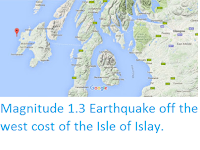
Magnitude 1.3 Earthquake off the west cost of the Isle of Islay.

The British Geological Survey recorded a Magnitude 1.3 Earthquake at a depth of about 7 km about 2.5 km off the west coast of the Isle of Islay in the Inner Hebrides Islands, at about 5.55 pm GMT on Sunday 20 March 2016. This was not a major event, and presented no threat to human life or property, but was felt on the island.
.
 The approximate location of the 20 March 2016 Isle of Islay Earthquake. Google Maps.
.
Earthquakes become more common as you travel north and west in Great Britain, with the west coast of Scotland being the most quake-prone part of the island and the northwest of Wales being more prone  to quakes than the rest of Wales or most of England. 

The precise cause of Earthquakes in the UK can be hard to determine; the country is not close to any obvious single cause of such activity such as a plate margin, but is subject to tectonic pressures from several different sources, with most quakes probably being the result of the interplay between these forces.

Britain is being pushed to the east by the expansion of the Atlantic Ocean and to the north by the impact of Africa into Europe from the south. It is also affected by lesser areas of tectonic spreading beneath the North Sea, Rhine Valley and Bay of Biscay. Finally the country is subject to glacial rebound; until about 10 000 years ago much of the north of the country was covered by a thick layer of glacial ice (this is believed to have been thickest on the west coast of Scotland), pushing the rocks of the British lithosphere down into the underlying mantle. This ice is now gone, and the rocks are springing (slowly) back into their original position, causing the occasional Earthquake in the process. 

(Top) Simplified diagram showing principle of glacial rebound. Wikipedia. (Bottom) Map showing the rate of glacial rebound in various parts of the UK. Note that some parts of England and Wales show negative values, these areas are being pushed down slightly by uplift in Scotland, as the entire landmass is quite rigid and acts a bit like a see-saw. Climate North East.
   
Witness accounts of Earthquakes can help geologists to understand these events, and the structures that cause them. If you felt this quake, or were in the area but did not (which is also useful information) then you can report it to the British Geological Survey here. 

See also...

http://sciencythoughts.blogspot.co.uk/2013/08/earthquake-on-rinns-of-islay.htmlEarthquake on the Rinns of Islay.                    A Magnitude 1.7 Earthquake at a depth of 2 km took place on the Rinns of Islay (the southwest peninsula of the Isle of Islay) at about 9.20 pm British Summertime (about 10.20 pm GMT) on Wednesday 31 July 2013...
http://sciencythoughts.blogspot.co.uk/2012/08/small-earthquake-on-islay-argyle-and.htmlSmall Earthquake on Islay, Argyle and Bute. On Monday 27 August, slightly before 2.00 pm British Summertime (slightly before 1.00 pm GMT), the British Geological Survey recorded a small Earthquake 8 km beneath the Rhinns of Islay Peninsula, to the west of Loch Indaal on the Island of Islay...
http://sciencythoughts.blogspot.co.uk/2012/07/isle-of-islay-shaken-by-two-earthquakes.htmlIsle of Islay shaken by two Earthquakes in two days.                                                        On Thursday 19 July 2012, slightly before 3.45 pm British Summertime (slightly before 2.45 pm GMT), the British...
Follow Sciency Thoughts on Facebook.

Friday, 2 August 2013

Earthquake on the Rinns of Islay.

A Magnitude 1.7 Earthquake at a depth of 2 km took place on the Rinns of Islay (the southwest peninsula of the Isle of Islay) at about 9.20 pm British Summertime (about 10.20 pm GMT) on Wednesday 31 July 2013, according to the British Geological Survey. This is a small Earthquake, and extremely unlikely to have caused any damage or casualties, but may have been felt locally.

The approximate location of the 31 July 2013 Islay Earthquake. Google Maps.

Earthquakes become more common as you travel north and west in Great Britain, with the west coast of Scotland being the most quake-prone part of the island and the northwest of Wales being more prone  to quakes than the rest of Wales or most of England.

The precise cause of Earthquakes in the UK can be hard to determine; the country is not close to any obvious single cause of such activity such as a plate margin, but is subject to tectonic pressures from several different sources, with most quakes probably being the result of the interplay between these forces.

Britain is being pushed to the east by the expansion of the Atlantic Ocean and to the north by the impact of Africa into Europe from the south. It is also affected by lesser areas of tectonic spreading beneath the North Sea, Rhine Valley and Bay of Biscay. Finally the country is subject to glacial rebound; until about 10 000 years ago much of the north of the country was covered by a thick layer of glacial ice (this is believed to have been thickest on the west coast of Scotland), pushing the rocks of the British lithosphere down into the underlying mantle. This ice is now gone, and the rocks are springing (slowly) back into their original position, causing the occasional Earthquake in the process. 

Witness accounts of Earthquakes can help geologists to understand these events, and the structures that cause them. If you felt this quake, or were in the area but did not (which is also useful information) then you can report it to the British Geological Survey here.


Follow Sciency Thoughts on Facebook.

Thursday, 30 August 2012

Small Earthquake on Islay, Argyle and Bute.

On Monday 27 August, slightly before 2.00 pm British Summertime (slightly before 1.00 pm GMT), the British Geological Survey recorded a small Earthquake 8 km beneath the Rhinns of Islay Peninsula, to the west of Loch Indaal on the Island of Islay in the Southern Hebrides, measuring 1.6 on the Richter Scale. Such a small tremor os highly unlikely to have caused any damage or casualties, and quite often will pass completely unnoticed, although on this occasion some people on the island reportedly did feel the quake.

Map showing the location of the 27 August Earthquake. BGS.

The UK is not close to any tectonic plate margins, so major Earthquakes are an unusual occurrence, but small quakes are not infrequent, and become more common as one travels north and west in the country, making the west coast of Scotland Britain's most Earthquake-prone area (which is possibly why people there are more likely to notice small tremors, and realize what they are).

The precise cause of quakes in the UK is seldom possible to determine, as the country is subject to tectonic stresses from a number of different sources, and most quakes are probably a result of a combination of these. The strongest source of stress in Scotland is probably glacial rebound; much of the north of the UK was covered by thick ice until about 10 000 years ago, pushing the rocks of the lithosphere down into the underlying mantle. Now this ice has gone and the rocks are slowly rebounding, causing the occasional small Earthquake in the process. The country is also being pushed to the east by the expansion of the Atlantic Ocean (along with the rest of Eurasia) and to the north by the impact of Africa into Europe from the south. There are also lesser spreading centers beneath the North Sea, Rhine Valley and Bay of Biscay, all of which exert tectonic pressure on the UK to some extent.


Follow Sciency Thoughts on Facebook.

Saturday, 21 July 2012

Isle of Islay shaken by two Earthquakes in two days.

On Thursday 19 July 2012, slightly before 3.45 pm British Summertime (slightly before 2.45 pm GMT), the British Geological Survey recorded an Earthquake 9 km beneath Loch Indaal on the Isle of Islay, off the west coast of Scotland, measuring 1.7 on the Richter Scale. Roughly 33½ hours later, slightly before 0.15 am British Summertime on Saturday 21 July (slightly before 12.45 pm on 20 July, GMT), a second quake was recorded beneath the Loch, this time at a depth of 6 km and measuring 1.3 on the Richter Scale.

The location of the July 2012 tremors. BGS.

Earthquakes this small are highly unlikely to cause any damage or injuries, and often people will fail to notice them at all, or not realize that they are Earthquakes, though on this occasion both were reportedly felt by local people. It is possible the inhabitants of Islay are more likely to notice such events than people in other parts of the country because they have more of them; as a rough rule of thumb the further north and west you go in the UK, the more Earthquakes you will encounter, and the west coast of Scotland is generally the most quake-prone part of the country.

The exact cause of quakes in the UK is often hard to determine; as the country is not close to any major source of tectonic movement, but rather is subject to minor geological stresses from a number of different sources. Earthquakes in Scotland are most often attributed to glacial rebound; until about 10 000 years ago much of the north of the UK was covered by a thick layer of ice, which pushed the rocks of the British lithosphere down into the underlying mantle; these rocks have been slowly rising back up ever since the ice melted, causing occasional Earthquakes in the process.

The UK is also subject to tectonic stresses caused by the expansion of the Atlantic Ocean, which is slowly pushing the entire of Eurasia to the east, and from the northward motion of Africa, which is pushing into Europe from the south. In addition there are smaller spreading centers beneath the North Sea, the Rhine Valley and the Bay of Biscay, all of which exert tectonic stresses upon Britain.

If you felt either of these quakes (or were in the area but didn't, which is also useful information) then you can report it to the British Geological Survey here. Witness statements help geologists understand how shock-waves travel through rock, which in turn helps them to build up a picture of the structures beneath the surface.


Follow Sciency Thoughts on Facebook.

Tuesday, 29 May 2012

Earthquake on the Isle of Islay.

On Monday 28 May 2012, at 3.07 pm, British Summertime (2.07 GMT), the British Geological Survey recorded an Earthquake in Loch Indaal on the Isle of Islay, about 2.5 km southwest of the island's administrative capital, Bowman. The quake was recorded as measuring 1.6 on the Richter Scale and occurring at a depth of 10 km. Such a small quake at thus depth is highly unlikely to have caused any damage or injuries, and may not even have been felt by anyone.

The location of the 28 May quake. BGS.

As a rule of thumb, the further north and west you travel in Great Britain the more Earthquakes you will encounter (though quakes large enough to cause significant damage are very rare), making the west coast of Scotland one of the most earthquake-prone areas of the country. The largest quake ever recorded in Scotland, on 28 November 1880 is thought to have been centered in Argyll, about 70 km northwest of the 28 May 2012 quake. This is thought to have measured 5.2 on the Richter Scale and to have occurred at a depth of 25 km (there were no seismometers in 1880, so these are estimates).

Most earthquakes in Scotland are attributed to glacial rebound; till about 10 000 years ago the northernmost parts of Britain were buried beneath hundreds of meters of ice, pushing the lithosphere down into the underlying mantle. Now this ice is gone the rocks are rebounding, albeit very slowly, and this can lead to Earthquakes.

This is slightly over-simplistic, as the rocks of Scotland are subject to stresses from a number of sources, and the origin of quakes is generally complex, without a single obvious cause. Eurasia, including Scotland, is being pushed to the east by the expansion of the Atlantic Ocean, and to the North by the impact of Africa from the south. There are also lesser centers of expansion beneath the North Sea, the Rhine Valley and the Bay of Biscay, all of which have some influence on rock movements beneath the UK.


Follow Sciency Thoughts on Facebook.