Showing posts with label Khaybar County. Show all posts

Tuesday, 16 January 2024

Investigating the walled oasis at Khaybar, Northwest Arabia.

Walled oases appear to have been a key part of the development of early settled societies on the Arabian Peninsula. Unlike other defensive systems, such as isolated towers, fortresses, or even walled cities, walled oases comprised an extensive system of defences enclosing an entire agricultural system, and marking a boundary between this managed farmland and the surrounding desert. Two such walled oases, Tayma and Qurayyah, have been familiar to archaeologists for a long time, and been the subject of numerous studies. However, recent examination of satellite images of the region has exposed a series of previously unknown walls around other oases, including Khaybar, Huwayyit, Dumat al-Jandal, Hait, Al-Wadi, Al-Ayn, and al-Tibq. This process of urbanization and oasis protection appears to have begun during the Bronze Age and persisted into the Iron Age, paying a major role in the appearance of the  caravan kingdoms.

Khaybar has a pre-Islamic period fortress located on a mesa at the centre of the great wadis which dominate the site, but a wall enclosing the entire oasis had not previously been observed or even suspected. The walls are spread over a wide area, and for the most part have been dismantled to the point at which they are hard to recognise. The area is rugged, and made up largely of basalt rock with almost zero sedimentation, so that any and all archaeological remains sit on the surface. This has created a lunar landscape, dotted with archaeological remains from a wide range of periods, including desert kites, mustatils, funerary avenues and dense necropolises, encampments, forts, plot walls, a range of less identifiable structures. To date, about 16 000 such structures have been counted within the 56 km² of land which constitutes the oasis. Determining that dismantled and fragmentary walls scattered over a wide area formed part of a single original structure requires extensive fieldwork and careful examination of the components.

In a paper published in the Journal of Archaeological Science: Reports on 10 January 2024, Guillaume Charloux, Shadi Shabo, Guillaume Chung-To, and Bruno Depreux of the French National Centre for Scientific Research, independent researcher François Guermont, Kévin Guadagnini, also of the French National Centre for Scientific Research, Thomas Therasse and  Mylène Bussy, also independent researchers, Saifa Alshilali of the Royal Commission for AlUla, Diaa Albukaai and Rémy Crassard, again of the French National Centre for Scientific Research, and Munirah AlMushawh, another independent researcher, demonstrate the presence of a defence wall around the entire Khaybar Oasis, as well as providing dating information on its construction and use.

Location map of the Khaybar walled oasis (red and white circle) and other major sites in north-western Arabia. Guillaume Charloux in Charloux et al. (2024).

Six seasons of fieldwork were carried out between October 2020 and March 2023, as part of the Khaybar Longue Durée Archaeological Project. Khaybar is about 670 m above sealevel, and is located in the Hijaz Region of Saudi Arabia, between Medina and AlUla. It was an important agricultural centre in the Early Islamic Period, with the entire oasis measuring about 8 km by 7 km. The oasis is at the confluence of three alluvial valleys, Wadi al-Suwayr/Halhal, Wadi al-Zaidiyyah, and Wadi al-Sulamah, which merge on the western side of the oasis to form the Wadi Khaybar. The wadis are cut into the surrounding Neogene-Quaternary basalt plateau, and contain a series of perched sediment beds. The first (brief) archaeological survey of the oasis was carried out in 2015. This was followed by an aerial survey by the Aerial Archaeology in Kingdom of Saudi Arabia project in 2018, with the Khaybar Longue Durée Archaeological Project beginning in 2020.

Aerial views of the dry-stone basement of the outer rampart: (A) Segment KH00911 facing south; (B) Segment KH01130 facing north; (C) Segments KH00904-KH00905 and KH00906 facing south; (D) segment KH00922. Guillaume Charloux in Charloux et al. (2024).

Charloux et al. used ArcGIS mapping software to combine aerial photography with high resolution geological maps and e architectural, archaeological and geomorphological surveys of the oasis to build up a map of the wall network. They also dug 19 test pits into sections of the remaining ramparts. 

Map of the main ramparts of Khaybar, with identification of main segment walls and location of bastions and soundings in 2021–2023. Guillaume Charloux in Charloux et al. (2024).

Charloux et al. discovered 5.9 km of previously unknown wall, 5.9 km of which are interpreted as being part of a network which once enclosed the entire oasis. There were 146 large wall segments remaining, ranging in length from a few metres to several hundred metres. The discovered walls were placed into five groups. Group A comprised aligned accretion walls 2.4-4.5 m thick, with both bastions and towers, and without any obvious discontinuity, which formed part of the enclosure surrounding the al-Natah Site. Group B walls comprised two exterior faces with a rubble in-fill, 1.4-2.4 m thick, with bastions, forming part of an inner enclosure wall. Group C walls were similar to Group B walls, but formed part of the outer perimeter enclosing the entire oasis. Group D walls are made from multiple types of masonry, are between 50 cm and 4 m thick, lack bastions, and again form part of an inner enclosure. Group E walls were smaller segments, similar in construction to Group D walls, which did not form part of any obvious larger structure.

View of the ramparts KH00905-KH00906 and a bastion KH00974 during excavation, looking west. Kévin Guadagnini in Charloux et al. (2024).

The remaining outer wall around the Khaybar oasis has a length of 5912.78 m, which is thought to represent 41% of an original wall which would have measured 14.5 km, enclosing an area of 11.8 km². The wall is interrupted by a variety of newer roads, buildings, gardens, etc., making it difficult to reconstruct the entire shape of the perimeter boundary, particularly on the southern side. 

Rampart KH00909, looking north. Charloux et al. (2024).

Seventy four bastions are still present on this outer wall, wall facing out towards the desert rather than in towards the oasis, which Charloux et al. consider to be strong evidence for the entire enclosure to have been built in a single phase of construction, albeit one which would have taken some time and been subject to subsequent additions and alterations.

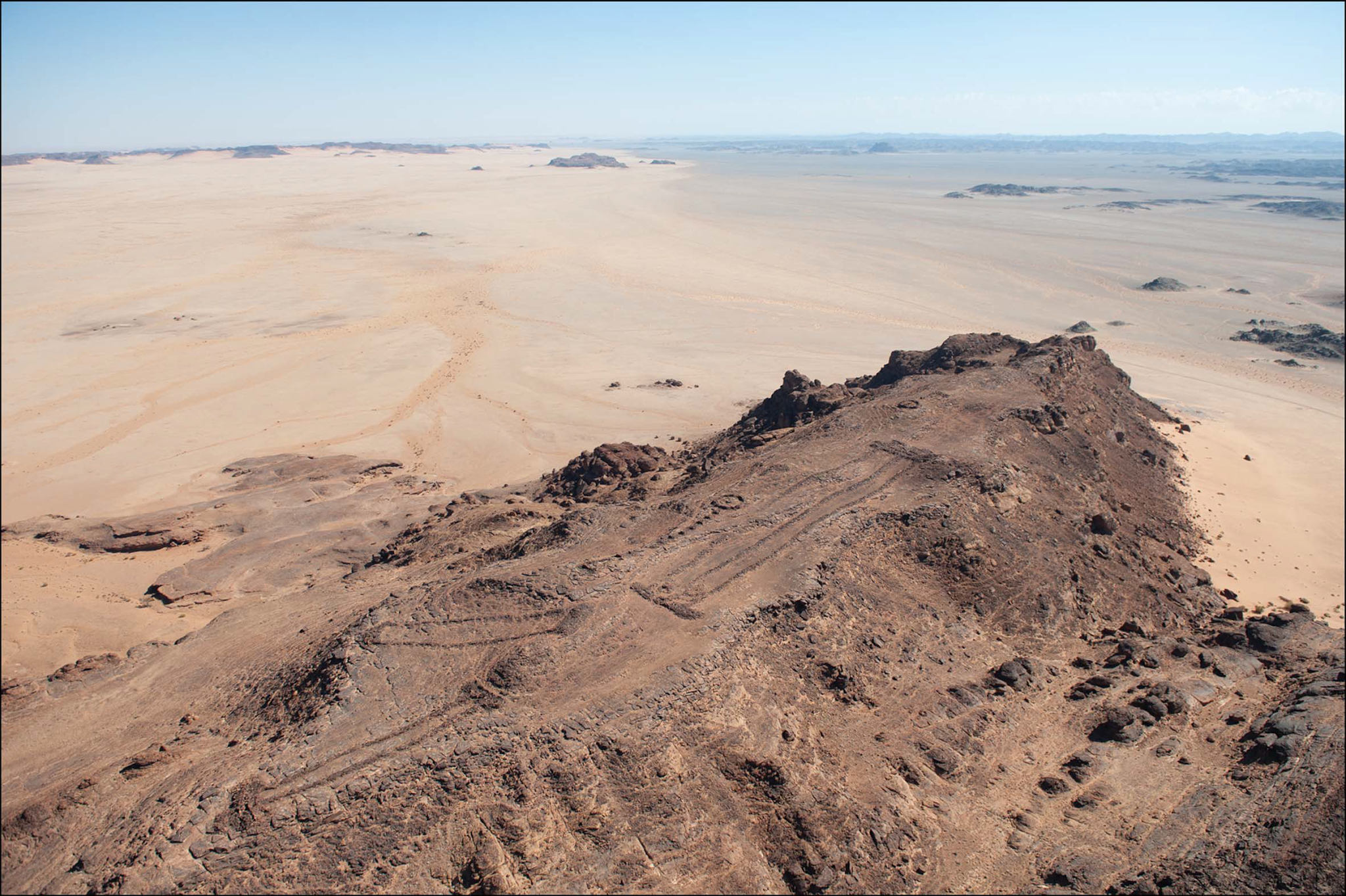
Rampart KH00911 situated on the crest (right on the picture), looking east. Guillaume Charloux in Charloux et al. (2024).

The walls of the outer perimeter are also very similar throughout their extent, most being rubble-filled, double-faced dry-stone walls, between 1.8 m and 2.4 m thick, which again supports a single interval of wall building. The walls appear to have been built in separate segments, with the thinnest section on the slopes and summits of Jabal Mushaqqar, where it is only 1.1 m thick and built of simple drystone masonry, which was apparently acceptable to the builders for this s high position along a ridge on the top of a rhyolite mountain. Earlier stone structures in the region appear to have been raided extensively for building stone.

View of the currently preserved masonry of the outer enclosure wall (rampart KH01130) facing north. Guillaume Charloux in Charloux et al. (2024).

The majority of the wall is made up of curvilinear sections which for the most part follow the contours of the plateau, with connections between these long sections crossing valleys at their narrowest points. Ramparts are between 120 m and 250 m from the cliff edge, apparently built at this distance to avoid the topological irregularities associated with the cliff. Building the wall in this way would have given good visibility over both the oasis and the surrounding desert, while enclosing the minimum amount without encroaching on the agricultural land.

Rampart KH00911 on top of the cliff, looking north. Guillaume Charloux in Charloux et al. (2024).

The height of the original walls is impossible to determine; only the stone bases of the walls remain, but there are traces of mud bricks in places, which suggests a brick superstructure existed on top of the stone wall. The highest remaining section of wall is 3 m tall, at Makidah on the southern section. Charloux et al. suggest another 2 m of brick wall may have existed on top of this, possibly with a walkway. The walls at the Tayma Oasis, have been estimated at 6 m high, with an inner enclosure which might have been 14 m high, while the walls at Dumat al-Jandal have been estimated at 6.5 m, and a section of walkway has been identified.

Rampart KH00919, with dismantled infilling, looking northeast. Guillaume Charloux in Charloux et al. (2024).

There are no contemporaneous structures attached to the outer wall, which is made of basalt and has been heavily eroded by the desert winds and runoff from the annual rains, as well as depletion due to raiding by later builders of other structures, all of which tend to make dating of any structure difficult. However, the wall is built over several older pendant tombs, some of which were also raided for stone by the wall builders. These tombs have been dated to the middle of the third millennium BC, which makes it impossible for the wall to have been built before about 2600-2200 BC. 

Rampart KH00918, looking northeast. Guillaume Charloux in Charloux et al. (2024).

Charloux et al. were able to obtain radiocarbon dates from eight charcoal samples obtained from five test pits sunk into the remaining wall segments. The oldest of these come from beneath the wall, providing a maximum age for the overlying wall segment. Other samples come from layers abutting the rampart or in the immediate vicinity of its foundation, suggesting they provide a time for the construction or first use of the wall, while other pieces come from the wall infill, which again makes it most likely they date from the time of wall construction. Finally, sone charcoal pieces come from beneath what appear to be gates in the wall, and could therefore have been deposited while the wall was in use.

Rampart KH00918, looking southwest. Guillaume Charloux in Charloux et al. (2024).

Based upon these radiocarbon dates, Charloux et al. suggest that the outer perimeter wall at Khaybar Oasis was built after 2279 BC, and probably after 2139 BC, but probably before 2201 BC and definitely before 1980 BC. The wall appears to have still been in use as late as 1741 BC and 1542 BC.

Location of dating samples on rampart KH00905 (plan on orthophotography and sections). Section 1: KH00906.002 and KH00906.004 are filling layers above ash area KH00906.005 on top of construction floor KH00906.006; Section 2: KH00905.002 is a collapse layer above a thin ash dump above fills KH00905.003 and KH00905.005 above possible construction floor KH00905.004. Guillaume Charloux, François Guermont & Kévin Guadagnini in Charloux et al. (2024).

This suggests that the Khaybar Oasis, one of the largest in Arabia, was enclosed by a perimeter wall in the Bronze Age, around 2000 BC. The appearance of such walled oases is thought to have been a key step in the evolution of urbanization in the region. The walls presumably offered protection against raids from the desert, a danger to settlements on the Arabian Peninsula in the pre-Islamic and Early Islamic Periods, but one for which evidence has been absent in the Bronze Age until now, despite the presence of Bronze Age 'Warrior Burials' in northern Arabia. Such walls may have also plaid a role in controlling the environment within the oasis, helping to prevent soils from blowing away and helping to prevent flash floods from reaching crops. The walls would also have made a symbolic statement about the ownership of the oasis, clearly delimiting a boundary between the territory inside the wall and the open desert. This would have been a powerful symbol to any desert groups seeing it, and presented a clear social identity to those within.

Dismantled bastion at the front of rampart KH00918, looking southwest. Guillaume Charloux in Charloux et al. (2024).

The size of the surrounding wall suggests that a reasonably large workforce was involved, and that local political leadership was sufficiently organized to co-ordinate such a project. It has previously been assumed that large building works like this in Bronze Age societies would have required very large numbers of workers, but recent evaluations of workloads has suggested that much smaller numbers of people might have been able to undertake large projects. Constructing the outer wall to a height of 5 m would have required the movement of 164 000 m³ of stone, and/or bricks, which Charloux et al. would have required 170 000 working days. Whilst this seems a lot, a community of 500 people, in which half of the population could spend six months of each year on the project, would have been able to construct the outer wall in four years. Had half the population been able to work on the project full time, then only two years would be needed to construct the wall. Furthermore, while some degree of planning would no doubt have been needed to complete the project, many of the choices which would have had to be made are not complicated, so a large bureaucracy was probably not needed, again suggesting the task was within the grasp of a relatively small community.

Test pit in gate KH09039 on rampart KH01130 (plan on orthophotography and section), with location of dated samples. Outside the gate, KH09039.004 is a small layer of brown gravel laying directly on the substratum below the stone collapse. Inside the gate, the collapse was underlain by KH09039.009, an occupation level consisting of grey, coarse sandy sediment with some charcoal and animal bones. Below, a layer of brown gravel (KH09039.010) was laying on the bedrock. Guillaume Charloux, François Guermont & Kévin Guadagnini in Charloux et al. (2024).

Pastoralists from northwest Arabia, where local communities were already building walled and fortified settlements on the fringes of the desert in what is now southern Lebanon and Syria, are thought to have settled at Khaybar Oasis during the Early Bronze Age, building avenues of monumental funerary structures, as at other oasis in the region, and on the trails between them. The skill set needed to build these large funerary structures is not greatly different from the one that would have been needed to construct fortified ramparts around an oasis, so the construction of avenues of funerary monuments hay have been the first stage in a transition from a pastoralist, nomadic existence to a more settled farming one where strategic territories with good water supplies were enclosed and defended. The nature of such projects would have favoured the development of a more hierarchical society, leading in time to the development of more formal urban centres. This settling and enclosing of the oases may have been linked to a drying climate, which would have made wandering pastoralism more precarious and reliable sources of water more precious, although the history of the climate in the region is not well enough understood to make firm assertions about this.

Rampart KH01130, looking north. Guillaume Charloux in Charloux et al. (2024).

Ramparts appear to have been erected around the entire oasis between about 2250 BC and 1950 BC, making these fortifications younger than the ones at Qurayyah, which were constructed in the first half of the third millennium BC, or and those at Tayma, built in the second half of the third millenium BC, but older than the Iron Age fortifications at Dûmat al-Jandal. This is interesting, as it shows a repeated process of oasis enclosure at different sites, over a lengthy period of time. Understanding why this happened would be a significant step in understanding the development of Bronze Age and Iron Age societies in Arabia, and the trajectory of urbanization followed there.

Reconstruction view of the northern part of walled oasis of Khaybar around 2000 BCE. Pending the results of definitive archaeobotanical analyses, the Plant cover at this stage is based on the identified species (Acacia, Tamarisk, Amaranth, cereals). Mylène Bussy & Guillaume Charloux in Charloux et al. (2024).

Charloux et al.'s field surveys and archaeological excavations have demonstrated that the Khaybar Oasis in Northwest Arabia was once enclosed by an immense surrounding wall, similar to that seen around other oases in the region. This dates from the late third millennium BC, and was probably constructed by a local pastoralist community settling and claiming the oasis as their territory. The walls appear to have remained in use for several centuries, before being partially dismantled and replaced with other structures. This marks out the oasis as an important stage in the development of urbanized communities in the region, and key part of the heritage of Arabia.

See also...

Friday, 30 July 2021

Interpretting the Neolithic Mustatils of northwestern Arabia.

The northwestern part of the Arabian Peninsula was, until fairly recently, believed to have been largely uninhabited until the onset of the Iron Age, in the twelfth century BC. However, recent research has suggested that the area may have been inhabbited for much longer, by peoples with unique cultural identities not seen elsewhere. This research has identified thousands of stone structures across northwestern (and other parts of) Arabia, which have become collectively known as the 'Works of Old Men', and which date from the Middle Holocene (6500-2800 BC) onwards. These structures come in a range of forms, including burrial cairns, tower tombs, 'pendant' tombs, megalithic structures, monumental Animal traps (or 'kites'), and a variety of open-air structures.

One of the forms of open-air structure commonly found in the region is the mustatil (مستطيل), large rectangular structures ('mustatil' is Arabic for 'rectangle'), which comprise two long, parallel walls 20-640 m in length, with two short walls or platforms making up the other sides of the rectangle. Additional dividing long walls are sometimes present, giving the structures the appearance of a European farm gate; they were originally termed 'Gates', but this description has been dropped as it was somewhat confusing. Around 1000 of these structures have now been discovered, scattered across an area of about 200 000 km², between latitudes of 22.989° and 28.064° north and longitudes of between 36.875° and 42.700° west, with the highest concentrations in AlUla and Khaybar counties.

Following a preliminary report in 2017, the Royal Commission for AlUla comissioned the Aerial Archaeology in the Kingdom of Saudi Arabia AlUla project to carry out a survey of the mustatil structures of AlUla County, as part of the Identification and Documentation of the Immovable Heritage Assets of AlUla programme. This was later joined by a second project, Aerial Archaeology in the Kingdom of Saudi Arabia Khaybar, concentrating on the mustatils of Khaybar County. These projects have used publicly available satellite images to identify mustatil structures in remote areas, followed by a series of helicopter surveys, with 1072 mustatils identified from satellite images, 276 photographed from the air, and 39 surveyed from the ground. Several of the mustatils visited were subject to preliminary excavations, revealing features that were not previously known.

In a paper published in the journal Antiquity on 30 April 2021, Hugh Thomas, Melissa Kennedy, Matthew Dalton, Jane McMahon, David Boyer, and Rebecca Repper, all of Classics and Ancient History at the University of Western Australia, present the results of these initial surveys of the mustatils of AlUla and Khaybar counties, Saudi Arabia.

Mustatil distribution across north-western Arabia. Thomas et al. (2021).

Northwestern Saudi Arabia has exposures of three major geological sequences; the Precambrian volcanic and sedimentary sequences of the Arabian Shield, a sequence of Cambrian-Ordovician sandstones, and a series of Cainozoic basalts, associated with the formation of the Red Sea, as the Arabian Peninsula rifted away from Africa. These different rock-types determine the geomorphology of the region, and therefore the distribution of its archaeological sites.

The largest landforms are in areas where the Cambrian-Ordovician sandstones have been eroded by water to form canyons and mesas. In drier areas, the landscape becomes progressively less varied, as wind erosion takes over from water erosion, till in desert areas there is an essentially flat, sandy landscape, with scattered yardangs (wind-eroded rocky outcrops), often with flattened hilltops, and blackened by desert varnish (a coating of fused clay and manganese particles that forms on rock surfaces not subject to water-erosion).

 
A group of three mustatils. Thomas et al. (2021).

The Cainozoic Harrat Basalts also form extensive landscapes, notably the Harrats Khaybar, Kura and Ithnayn lavafields, and the Harrat Uwayrid basalt plateau north-west of AlUla. The oldest of these lavafields are Miocene in age, and have flat or gently undulating flow surfaces with few clay pans, while younger, Pliocene-Early Holocene examples form hummocky, ‘whale-back-style’ terrains, with large clay-filled depressions and localised higher relief around volcanic vents. 

Mustatils are found on all these landscapes, but their placement and form varies with landscape type.

All Mustatils are distinguished by the presence of a head, courtyard, and base, but some also associated with other features, such as orthostats (standing stones) and circular cells.

 
The head of a mustatil, note the chamber in the centre of the platform. Thomas et al. (2021).

The head of a mustatil typically comprises a dry-stone platform, rectangular or sub-rectangular in shape, 10-50 m in length, and 30-120 cm high. These were made from flat slabs of sandstone where these were available, but otherwise chunks of the local rock stacked together. In most of the investigated mustatils, a single oval or rectangular chamber, ranging in size from 2.8 x 2.8 m to 10 x 3 m, was present at the centre of the head. In some cases a doorway, less than 50 cm wide, connected this chamber to the main courtyard. In some instances this doorway had been deliberately blocked off, either with a single capstone or a pile of smaller stones, possibly when the site was decommissioned. Some of the chambers also have other features, notably niches.

 
Features of mustatil: (A) internal niche located in the head of a mustatil; (B) a blocked entranceway in the base of a mustatil; (C)–(D) associated features of a mustatil: cells and orthostats; (E) stone pillar identified on the Harrat Khaybar lava field. Thomas et al. (2021).

The courtyards of mustatils were rectangular, elongate areas, bounded by the head, the base, and the long walls. These appear to have been open spaces when in use; some examples have other structures within the courtyard area, such as smaller enclosures or funerary structures, though these are thought to post-date the original usage.

The long walls comprise two rows of laid stones filled with a rubble core. The laid stones were arranged either horizontally or vertically, with only a single example showing a mixture of horizontal and vertical stones. These walls varied between 50 cm and 3 m in width, and from 30 cm and 120 cm in height.

The base of the mustatils typically had an entrance 30-80 cm in width (sometimes slightly wider), directly opposite the central chamber in the head. Some of these entranceways also appear to have been blocked when the sites were decommissioned, sometimes symbolically with a few stones on either side, sometimes with the entire entrance being infilled.

 
Aerial image of three mustatil bases. Note the associated features (cells and orthostats) and blocked entranceways. Thomas et al. (2021).

Sixty five of the 109 sites surveyed from the ground or air had circular cells in front of their bases. These could be discrete, or interlocking, with each site having between three and eight such structures; although the number may actually be higher, as at many sites these have been partially covered by wind-blown sand. At sites with discrete cells, these cells are 1-2 m in diameter, and tend to all be the same size at any given site. At sites with interlocking cells the outermost cells tend to be 1.0-1.3 m in diameter, with the cells increasing in size progressing inwards, so that the largest, inermost cells are 1.8-2.0 m in diameter. These cells are aranged parallel to the base of the mustatil, with a passageway thus formed between the cells and the entrance to the courtyard. In five of the examined mustatils, these passageways had also been blocked, either deliberately or by collapse of the structures. At seven of the examined sites, the cells contained central orthostats (standing stones), fashioned from local stone and 1-1.5 m in height.

The mustatils surveyed on the Harrat Khaybar lava field differed slightly from mustatils surveyed elsewhere, in that they lacked orthostats, but instead had pillars of carefully stacked local stone, probably relating to a lack of suitable marterial to make true orthostats. These pilars occurred in clusters, with up to 50 seen at a single site.

The initial survey of the mustatil sites noted that many had associated 'I'-shaped structures, which have subsequently been shown to comprise low, rubble-filled platforms with an exterior face. These are quite variable in form, varying from structures that are distinctly 'I'-shaped to simple rectangular forms; the variation in shape in these structures closely aligns with variations in the shape of mustatils, with the two structures sharing a similar distribution range, although 'I'-shaped structures are less common, Similar rectangular structures are also known from southern Jordan, although it is unclear if these are related.

 
(A)–(B) I-type platforms; (C)–(D) rectilinear platforms. Thomas et al. (2021).

A total of 131 'I'-shaped structures have been recorded, of which 73 are adjacent to a larger mustatil. These are typically parallel to the mustatil, and aligned with either the base or a long wall. Up to six 'I'-shaped structures can be associated with a single mustatil, with the 'I'-shaped structures varying in size from 16 x 7 m to 42 x 16 m. These structures never cut across mustatils, and never use stone recycled from them, suggesting that they were in use at the same time, and, therefore, where the two are placed side-by-side, they were somehow functionally related. 

The examined mustatils vary considerably in form and shape, but have some consistent feature. Thomas et al. propose they be subdivided into two broad types; 'simple' mustatils with roughly rectangular shapes defined by a head, a base and two long walls, with may-or-may not have an entranceway in the base, but usually lack it, and 'complex' mustatils, which are similar in form, but always have an entrance, which is associated with other structures, such as circular cells and orthostats or pillars. They further note that the 'I'-shaped structures are only ever found in association with complex mustatils.

 
(A) ‘Simple’ mustatil; (B)–(C) ‘complex’ mustatils, single (B) and double (C). Thomas et al. (2021).

However, variations are present in both types of mustatil. Notably, additional long walls dividing the courtyard may be present in either simple or complex foems, Most mustatils appear to have been built in a single phase of construction, although some show signs of later modification. Bith simple and complex mustatils are found across the entire range of the structures, with their distribution apparently being random within this range.

The majority of mustatils are built upon exposed bedrock. They do not appear to be oriented towards any particular object or direction, but instead follow the local topography, somthing that varies greatly across the area, depending on the local geology. Where mustatils are built upon slopes, it is always with their long access perpendicular to the slope, while mustatils located on narrow sandstone ridges are arranged to allow the maximum length. On flat ground mustatils show no preferential orientation.

 
Geographic positioning of different mustatils. Thomas et al. (2021).

Where possible, the head of mustatils appears to have been deliberately places higher than the rest of the structure, something especially true of mustatils located on the rocks of the Precambrian Shield., but less marked on exposed sandstone outcrops, where the entire structure is typically located on a flat mesa surface. Arranging the mustatils in this way would have been more difficult on the younger volcanic terrains, but even hear these structures are often clustered around vents, enabling the head to be highest. emphasising how important this arrangement must have been. The majority of 'I'-shaped structures and rectangular platforms are also built on slopes. Mustatils placed upon hillslopes are visible from a great distance, which may have been the intention of such placement; those placed upon flat mesas above the wider plain are effectively hidden from sight, but themselves command excellent views. It therefore seems likely that visibility of and from the mustatils was important to their builders in some way.

Mustatils are often found clustered together, with up to 19 individual mustatils found in groups where none is further than 500 m from its neighbour. The mustatils of the Harrat Khaybar are more concentrated into groups than elsewhere, but this phenomenon is found across the entire geographical range of these structures. The reasons for this are unclear, though Thomas et al. suggest that a better understanding of the chronology of the sites construction and use might prove enlightening.

Excavations at the IDIHAF-0011081 mustatil site in eastern AlUla County have revealed a central chamber at the head in which a number of horns and skull fragments from Cattle, Sheep, Goats, and Gazelles have been placed around a central upright stone in the centre of the chamber. These remains are dominated by Cattle, and are assumed to have been some form of ritual sacrifice. No Human remains were found at the site, nor any signs of domestic occupation. Radiocarbon dates were obtained from a tooth and horn, which suggests that the animals from which these came were alive in the sixth millennium BC (Late Neolithic).

 
Artefacts recovered during excavation and ground survey: (A) Cattle horn positioned in front of a betyl (standing stone) at IDIHA-F-0011081; (B)–(C) cattle horns recovered from IDIHA-F-0011081; D) Neolithic micro core collected from IDIHA-F-0003301; (E) Neolithic bifacial foliate identified at IDIHA-F-0011394. Thomas et al. (2021).

A sample of charcoal that was obtained from a looted mustatil located to the south of the Nefud Desert produced a late sixth to early fifth millennium BC radiocarbon date, and faunal remains similar to those from the one excavated by Thomas et al. The type, and positioning, of these remains strongly suggests that the mustatils had a ritual purpose, as does the prominence of the mustatils in the landscape. This is supported by the fact that no mustatil investigated to date has produced any sign of occupation, and absence of any indication of any mustatil having ever been roofed. Orthostats have also been found at other sites in Arabia interpreted as having been used for ritual purposes, which again supports the idea that this was the purpose of the mustatils. The narrow entrances and elongate structures of the mustatils suggest that the rituals carried out within them may have been of a processionary nature, with participants moving in single-file from the entrance to the head.

Stone tools were found at four of the 39 mustatils investigated on the ground. These include a flaked micro core, an obsidian bifacial foliate, and some non-diagnostic flakes and debitage. However, most of the courtyards were devoid of any tools or other cultural material.

Mustatils are commonly found in association with other structures, including, funerary monuments and 'kites'. A total of 118 such associations were found in the aerial surveys, with the mustatils often being overbuilt by, or structurally robbed to build, the other structures. This implies that the mustatils are older than these other structures, and apparently the oldest structures in the area. In some cases, one mustatil appears to overlie another.

There are no known Human burials of similar age to the mustatils in northwestern Arabia. However, many later tombs are closely geographically associated with mustatils, including ringed tombs, with and without pendant tails. These 'pendant' tombs have been dated to between the fourth millennium BC and the second century AD, again supporting the idead that these structures were built after the mustatils, and that in some instances material was looted from mustatils to help build them.

Five examples of mustatils being overlain by 'kite' structures, and one, possible example of a mustatil overlying a 'kite'-structure. Kite structures are again thought to be fourth-to-third millennium BC in age, making them Neolithic in age, although more work needs to be done on these structures.

In all cases mustatils have been built from readily available local stone, which has affected the construction methods used, as well as the appearance and durability. Sandstone tends to split along bedding planes due to natural processes, forming a natural flagstone rock. A similar effect can be obtained using metamorphic schists, which are common in parts of the Precambrian Arabian Shield. In both cases the rock can be extracted in sheets by hand or using wooden tools. This will yield both flagstones from which walls can be made and larger rocks which can be placed upright to produce orthostats. Many of the rocks used in the construction of the mustatils are such sheets, with examples exceeding 500 kg in weight not unusual. Where walls are made from such flagstones they can be fitted together tightly, and are resilient to collapse, unlike walls made from more rounded stones, such as those available on basalt terrains.

The largest Mustatil that Thomas et al. surveyed on the ground was located on the Harrat Khaybar lava field, 50km south of the town of Khaybar. This is 525 m long and made from basalt boulders. Assuming that basalt has a density of 2500 kg/m³, Thomas et al. estimate that the construction of this site would have required the moving of 12 000 tonnes of rock, with the individual rocks used weighing from 6 to 500 kg.

Methods of estimating the amount of time and labour needed to construct stone monuments have been developed by archaeologists working on Mayan structures in the New World, and there were applied by Thomas et al. to the mustatils. This led them to conclude that a group of ten people could construct a 150 m mustatil in twe-to-three weeks, and that a 500 m mustatil could be built by a team of fifty people in about two months. Thus, most of the mustatils could have been built by small groups of workers in a relatively short period of time, and even the largest could have been constructed by a family group in a few months, and potentially much less time if several family groups worked together. The construction of mustatils could, therefore, have formed part of a broader Neolithic development of community and power structures, and possibly served as a means of maintaining social cohesion amoungst widely dispersed and/or nomadic pastoralist communities.

Understanding why the mustatils were built requires a wider understanding of the culture that produced them. They appear to date entirely from the Late Neolithic, and possibly represent a new culture moving into the area, as climatic variations in Arabia during the Late Pleistocene and Ealy Holocene are thought to have driven repeated colonisation of, and withdrawal from, areas by different Neolithic peoples, resulting in distinctive regional cultures across the landmass. The relationship between the mustatil-building culture and the Holocene Humid Phase (roughly 8000–4000 BC) is unclear.

The ritually deposited Cattle remains at site IDIHA-F-0011081 appear to represent the oldest known evidence for Cattle on the Arabian Peninsula, and therefore the arrival of an important economic resource for Neolithic pastoralists. Cattle are important in rock art from the Arabian Late Neolic, but the earliest known evidence for Cattle comes from Shi’b Kheshiya in Yemen, where there are a number of structures thought to have been associated with Cattle, and dates to about 4400 BC, making it about 900 years younger than site IDIHA-F-0011081.

The large size of the mustatils, and the way in which their makers were able to construct to a common plan over a very wide area, suggests that these structures were imoportat the their makers, and conveyed some connection with the land, possibly serving as terrirory boundaries, or sites of some ritual right of passage. On other parts of the peninsula, burial structures may have served a similar function,

No structures closely resembling mustatils are known from anywhere else, although a number of large, rectangular, open-air 'sanctuaries' are known from the Negev Desert, and these also date to the sixth millennium BC. However, while these share the same basic form as the mustatils, they show no similarity in placement or building methodology, making it unclear if there is any relationship. What the mustatils do appear to be is one of the first examples of a strictly ritual structure in the Neolithic of the Near East.

Mustatils are found across a wide area of northwestern Arabia, showing a remarkable level of structural conservatism, albeit with adjustments for local geology. Understanding the context in which these structures were built is clearly highly important for understanding the developing cultures of the Middle Holocene in the area, and the number of these monuments may indicate that this landscape may have supported a far higher population at this time than was previously thought.

See also...


Follow Sciency Thoughts on Facebook.

Follow Sciency Thoughts on Twitter.