Showing posts with label Napa County. Show all posts

Sunday, 15 October 2017

Wildfires kill at least 40 in California.

Forty people have died and many more are missing in a series of wildfires that have swept across California's Napa Valley this week. At least fifteen fires are still burning across the northern part of the state, where over 890 square kilometres of farmland and 5700 buildings have been destroyed. More than 10 000 firefighters from California and neighbouring states are currently fighting the fires.

Fires burning in Peters Canyon Regional Park in Orange County, California, earlier this week. Irfan Khan/Los Angeles Times.

The worst of this fires is in Sonoma County, where an incident named the Nuns Fire, started by a downed power line hitting  tree, has destroyed almost 200 square kilometres of land have been burned and the outskirts of the cities of Sonoma and Santa Rosa affected, and a second incident, the Tubbs Fire, so called because it started near Tubbs Lane near the city of Calistoga has destroyed over 140 square kilometres of land between Calistoga and Sonoma, resulting in 22 deaths.

 Burning buildings to the east of Healdsburg in Sonoma County earlier this week. J Morris/San Francisco Chronicle.

In Mendocino County a fire named the Redwood Fire has destroyed around 130 square kilometers of land and destroyed around 90 buildings. Eight people are understood to hav edied on the first day of this fire, prompting the evacuation of a further 5000 from homes in its path. A further six people have died and a further 76 are missing in Napa County, where a blaze called the Atlas Fire has destroyed around 200 square kilometers of land, including much of the county's winelands. In Yuba County four people have died in the Cascade Fire, which has destroyed around 40 square kilometres of land.

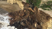
The remains of the Signorello Estate Winery in Napa County, California, destroyed by wildfires this week. Justin Sullivan/Getty Images.

The fires have a variety of causes and have been fueled by dry winds blowing from the mountains in the northeast of the state, but are essentially due to a prolonged drought in the state, which has been experiencing dry conditions since 2011, the longest such drought in the state's recorded history. This drought has killed vegetation, including thousands of trees, across much of central California, providing dry tinder to fuel the fires, despite high rainfall that caused flooding in parts of the state in the winter of 2016-7. The draught has been made worse by the diversion of water to suit Human purposes, such as agriculture, industry and leasure, which has taken water away from other ecosystems, resulting in the build-up of dead, dry vegetation that has produced fuel for the fires.

Dry vegetation near Shandon in San Luis Obispo County, California, in May 2015. Al Seib/Los Angeles Times.

See also...

http://sciencythoughts.blogspot.co.uk/2017/10/sewage-spill-closes-beaches-in-orange.htmlhttp://sciencythoughts.blogspot.co.uk/2017/09/british-tourist-killed-by-rockfall-on.html
http://sciencythoughts.blogspot.co.uk/2017/09/state-of-emergency-declared-in-san.htmlhttp://sciencythoughts.blogspot.co.uk/2017/07/magnitude-51-earthquake-off-coast-of.html
http://sciencythoughts.blogspot.co.uk/2017/04/evacuations-following-landslide-in.htmlhttp://sciencythoughts.blogspot.co.uk/2017/02/sinkhole-swallows-two-cars-in-studio.html
Follow Sciency Thoughts on Facebook.

Sunday, 24 May 2015

Magnitude 4.1 Earthquake in Napa County, California.

The United States Geological Survey recorded a Magnitude 4.1 Earthquake at a depth of about 13 km about 6 km to the east of Yountville in Napa County, California, slightly after 7.50 pm local time on Thursday 21 May 2015 (slightly after 2.50 am on Friday 22 May, GMT). There are no reports if any damage or injuries associated with this event, though it was felt across much of Napa and Sonoma counties.

The approximate location of the 22 May 2015 Napa County Earthquake. Google Maps.

California is extremely prone to Earthquakes due to the presence of the San Andreas Fault, a tectonic plate margin that effectively bisects the state. The west of California, including Santa Barbara and Los Angeles, is located on the Pacific Plate, and is moving to the northwest. The east of California, including Fresno and Bakersfield is on the North American Plate, and is moving to the southeast. The plates do not move smoothly past one-another, but constantly stick together then break apart as the pressure builds up. This has led to a network of smaller faults that criss-cross the state, so that Earthquakes can effectively occur anywhere.

The extent of and movement on the San Andreas Fault. Geology.

See also...

The United States Geological Survey recorded a Magnitude 3.6 Earthquake to the north of San Ramon in Contra Costa County, California, slightly after...


A woman has died and her male companion has been severely injured following a cliff collapse at the Point Reyes National Seashore to the northwest of San...


The United States Geological Survey recorded a Magnitude 6.0 Earthquake at a depth of 11.3 km in southern Napa County, California, at about 3.20 am local time (bout 10.20 am GMT) on Sunday 24...


Follow Sciency Thoughts on Facebook.

Monday, 25 August 2014

Over 150 injured after Earthquake in Napa County, California.

The United States Geological Survey recorded a Magnitude 6.0 Earthquake at a depth of 11.3 km in southern Napa County, California, at about 3.20 am local time (bout 10.20 am GMT) on Sunday 24 August 2014. This was a fairly large event, and the Queen of the Valley Medical Center in Napa City has reported 172 people being treated for injuries, three of them serious, one of whom has been described as a child. A large amount of damage has also been reported, with six fire breaking out as a result of the event, and 33 buildings in Napa City declared unsafe to enter due to damage. The area has been hit by a number of aftershocks following the initial event.

A building in Napa City, California, damaged by the 24 August 2014 Earthquake. AFP.

California is extremely prone to Earthquakes due to the presence of the San Andreas Fault, a tectonic plate margin that effectively bisects the state. The west of California, including Santa Barbara and Los Angeles, is located on the Pacific Plate, and is moving to the northwest. The east of California, including Fresno and Bakersfield is on the North American Plate, and is moving to the southeast. The plates do not move smoothly past one-another, but constantly stick together then break apart as the pressure builds up. This has led to a network of smaller faults that criss-cross the state, so that Earthquakes can effectively occur anywhere in the state.

The approximate location of the 24 August 2014 Napa County Earthquake. Google Maps.

Witness accounts of Earthquakes can help geologists to understand these events and the underlying structures that cause them. If you felt this quake (or if you were in the area but did not, which is also useful information) then you can report it to the United States Geological Survey here.

See also...


The United States Geological Survey recorded a Magnitude 4.5 Earthquake at a depth of 2.6 km, 6 km to the north of The Geysers...


The United States Geological Survey recorded a Magnitude 3.0 Earthquake at a depth of 6.4 km, roughly 7 km to the northwest of...


The United States Geological Survey recorded a Magnitude 2.6 Earthquake at a depth of 1.8 km in northeast Sonoma County in...


Follow Sciency Thoughts on Facebook.