Showing posts with label Transform Plate Margin. Show all posts

Thursday, 25 June 2026

Northern Venezeula hit by pair of major Earthquakes, leaving at least 164 dead.

The United States Geological Survey recorded a Magnitude 7.2 Earthquake at a depth of 20.3 km, roughly 23 km to the southeast of the town of Yumare in Yaracuy State on the north coast of Venezuela, slightly before 6.05 pm local (slightly before 10.05 pm GMT) time on Wednesday 24 June 2026. This was followed after 39 seconds by a Magnitude 7.5 Earthquake 4 km to the southeast of the original event, at a depth of 10 km. 

The approximate location of the second 24 June 2026 Yaracuy Earthquake. USGS.

At least 164 people are known to have died as a result of this event, with another 971 injured. However, more than a hundred buildings have collapsed as a result of the Earthquakes, it is thought likely that many thousands more people may be trapped or dead beneath the rubble. The worst of the damage occurred in the State of La Guaira, to the east of the epicentres of the events.

A partially collapsed apartment building in the city of Catia La Mar in the State of La Guaira, Venezuela. Federico Parra/AFP/Getty Images.

The northern coast of Venezuela forms the boundary between the South American Plate, which is being pushed to the west by the expansion of the Atlantic, and the Caribbean Plate, which is also being pushed westward, but at a slower rate due to a collision with the Cocos Plate (which lies to the west of Central America). This means that the two plates are moving past one-another, creating a transform plate margin. This is not a smooth process, rather the plates constantly stick together, causing pressure to build up, then break apart in often spectacular earthquakes.

See also...


Wednesday, 26 June 2024

Magnitude 6.0 Earthquake off the north coast of the Paria Peninsula, Venezuela.

The United States Geological Survey recorded a Magnitude 6.0 Earthquake at a depth of 87.4 km, slightly  off the  north coast of the Paria Peninsula on the north coast of Venezuela, slightly before midnight on Sunday 23  June 2024 local time (slightly before 4.00 am on Monday 24 June GMT). This was a large quake, but at some depth as well as offshore, and there are no reports of any casualties or damage, though the quake was felt over a large area, with people reporting feeling it across much of northern Venezuela, and northeastern Guyana as well as on the Caribbean islands of  Trinidad, Granada, St Vincent.

The approximate location of the 24 June 2024 Paria Peninsula Earthquake. USGS.

The Paria Peninsula forms part of the southern margin of the Caribbean Plate, which is moving eastward compared to the South American Plate, upon which the rest of Venezuela sits. This is not a smooth process, the two plates constantly stick together, then break apart as the pressure builds up, causing Earthquakes in the process. 

See also...

Sunday, 28 May 2023

Magnitude 6.5 Earthquake off the northern coast of Panama and Colombia.

The United States Geological Survey recorded a Magnitude 6.5 Earthquake at a depth of 13.0 km, off the Caribbean coasts of Panama and Colombia, about 50 km to the northeast of the border between the two countries, slightly after 10.05 pm local time on Wednesday 24 May 2023 (slightly after 3.05 am on Thursday 25 May, GMT). There are no reports of any damage or casualties associated with this event, though it was felt across much of northern Colombia, Panama and parts of Costa Rica.

The approximate location of the 24 May 2023 Pananma/Colombia Earthquake. USGS.

The event happened close to the triple junction between the Panama, Caribbean, and South American plates. All three plates are drifting to the northwest, being pushed by the expansion of the Atlantic Ocean, and to a lesser extent the eastward movement of the Nazca Plate, which is being subducted beneath the South American Plate along the west coast of South America. However, the South American Plate is moving somewhat faster than the other two plates, causing the Panama Plate to be pushed to the west, creating a transform plate margin, as the Panama Plate moves west relative to the Caribbean Plate, along the northern coast of Panama, and a subductive plate margin, as the Caribbean Plate is forced under the advancing South American Plate, along the northern coast of Colombia. 

The tectonic plates underlying Central America and the surrounding areas. Wikimedia Commons.

See also...


Follow Sciency Thoughts on Facebook.

Follow Sciency Thoughts on Twitter


Friday, 14 January 2022

Magnitude 3.9 Earthquake in Riverside County, California.

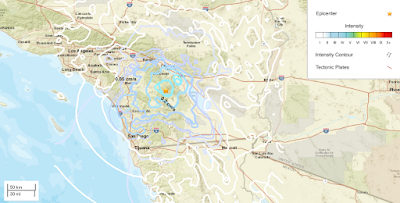
The United States Geological Survey recorded a Magnitude 3.9 Earthquake at a depth of about 14.0 km roughly 23 km to the southeast of Azna in Riverside County, California, slightly before 7.200 pm local time on Wednesday 12 January 2022 (slightly before 3.20 am on Thursday 13 January GMT). There are no reports of any damage or injuries relating to this quake, but people have reported feeling it across much of southern California.

 
The approximate location of the 12 January 2022 Riverside County Earthquake. USGS.

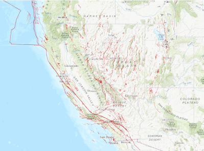
California is extremely prone to Earthquakes due to the presence of the San Andreas Fault, a tectonic plate margin that effectively bisects the state. The west of California, including Santa Barbara and Los Angeles, is located on the Pacific Plate, and is moving to the northwest. The east of California, including Fresno and Bakersfield is on the North American Plate, and is moving to the southeast. The plates do not move smoothly past one-another, but constantly stick together then break apart as the pressure builds up. This has led to a network of smaller faults that criss-cross the state, so that Earthquakes can effectively occur anywhere.

 
Tectonic boundaries and faults in California and the surrounding area. USGS.

Witness accounts of Earthquakes can help geologists to understand these events and the underlying structures that cause them. If you felt this quake (or if you were in the area but did not, which is also useful information) then you can report it to the United States Geological Survey here.

See also...


Follow Sciency Thoughts on Facebook.

Follow Sciency Thoughts on Twitter.
 

Tuesday, 15 December 2020

Magnitude 3.9 Earthquake beneath the northern Gulf of Aqaba.

The United States Geological Survey recorded a Magnitude 3.9 Earthquake at a depth of 10.0 km, beneath the Gulf of Aqaba, roughly 3 km off the coast of the city of Aqaba in southern Jordan, at about 5.30 am local time (about 2.30 am GMT) on Tuesday 15 December 2020. There are no reports of any serious damage or injuries from this quake, but people have reported feeling it in Jordan and Israel.

 
The approximate location of the 15 December 2020 Gulf of Aqaba Earthquake. USGS.

The Gulf of Aqaba lies on the boundary between the African and Arabian Plates, and is bisected by the Dead Sea Transform Margin (sometimes the Levant Transform Margin or Levant Transform Fault), with the east of the country located on the Arabian Plate, and the west on the African Plate. Both of these plates are moving northward, but the Arabian Plate is moving at a greater rate, driven by seafloor spreading beneath the Red Sea, creating a leading to transform movement on the plate margin that runs through the Gulf of Aqaba, the Dead Sea, and Lebanon, with the Arabian Plate moving northward relative to the African Plate. 

 
The relative movements of the African and Arabian Plates. School of Earth and Environment/University of Leeds.

Sea floor spreading is occurring at a faster rate beneath the southern Red Sea than the north, with the effect that the Arabian Plate is also rotating relative to the African Plate. This results in a slightly complex situation in Lebanon, with a network of faults underlying the region, all with the potential for movement, which can result in quakes anywhere in the country.

See also...


Follow Sciency Thoughts on Facebook.

Follow Sciency Thoughts on Twitter.
 

Saturday, 5 December 2020

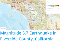
Magnitude 3.7 Earthquake in Riverside County, California.

The United States Geological Survey recorded a Magnitude 3.7 Earthquake at a depth of about 3.1 km roughly 6 km to the southwest of Aguanga in Riverside County, California, slightly after 9.40 pm local time on Friday 4 December 2020 (slightly after 5.40 am on Saturday 5 December GMT). There are no reports of any damage or injuries relating to this quake, but people have reported feeling it across much of southern California.

 
The approximate location of the 4 December 2020 Riverside County Earthquake. USGS.

California is extremely prone to Earthquakes due to the presence of the San Andreas Fault, a tectonic plate margin that effectively bisects the state. The west of California, including Santa Barbara and Los Angeles, is located on the Pacific Plate, and is moving to the northwest. The east of California, including Fresno and Bakersfield is on the North American Plate, and is moving to the southeast. The plates do not move smoothly past one-another, but constantly stick together then break apart as the pressure builds up. This has led to a network of smaller faults that criss-cross the state, so that Earthquakes can effectively occur anywhere.

Tectonic boundaries and faults in California and the surrounding area. USGS.

Witness accounts of Earthquakes can help geologists to understand these events and the underlying structures that cause them. If you felt this quake (or if you were in the area but did not, which is also useful information) then you can report it to the United States Geological Survey here.
 
See also...


Follow Sciency Thoughts on Facebook.

Follow Sciency Thoughts on Twitter.