Showing posts with label Bay of Bengal. Show all posts

Sunday, 7 December 2025

Number of dead in Sri Lanka following Cyclone Ditwah has now reached 619.

The number of people known to have died after Cyclone Ditwah made landfall in Sri Lanka on 28 November 2025 has reached 219, making the storm the worst natural disaster to befall the nation since the Boxing Day Tsunami of 2004. A further 209 people are still recorded as missing since the storm, with 18 people listed as having been injured. About 2 million people (almost 10% of the population) are thought to have been affected in some way by the storm, with 4071 homes destroyed and 71 121 damaged by flooding and landslides, as has much of the island's infrastructure and agricultural land. Authorities in Sri Lanka are warning that there is still a high risk of landslides, as monsoon rains fall onto already soaked hillside soils. Landslides are a common problem after severe weather events, as excess pore water pressure can overcome cohesion in soil and sediments, allowing them to flow like liquids. Approximately 90% of all landslides are caused by heavy rainfall.

Flooding in the Gampaha District of Colombo, Sri Lanka, following the passage of Cyclone Ditwah. Incept Change/UNICEF. 

Cyclone Ditwah was first detected as a tropical depression off the south coast of Sri Lanka by the Indian Meteorological Department on 26 November 2025. This depression increased in strength, becoming first a deep depression and then a cyclonic storm of 27 November. It crossed over Sri Lanka on the night of 28-29 November, bringing catastrophic levels of rainfall, then moved out over the Bay of Bengal. The storm continued to move northwatds along the Coromandel Coast, in the process bringing more flooding to the states of Tamil Nadu and Puducherry, which led to three Human and 149 Cattle deaths, as well as flooding much farmland, and damaging or destroying 234 homes. The storm weakened as it moved northward, eventually making landfall in Tamil Nadu as a low pressure system on 3 December.

Flood damage beside the Mahaweli River in Kandy, Sri Lanka, following the passage of Cyclone Ditwah. Reuters.

Tropical storms are caused by the warming effect of the Sun over tropical seas. As the air warms it expands, causing a drop in air pressure, and rises, causing air from outside the area to rush in to replace it. If this happens over a sufficiently wide area, then the inrushing winds will be affected by centrifugal forces caused by the Earth's rotation (the Coriolis effect). This means that winds will be deflected clockwise in the northern hemisphere and anti-clockwise in the southern hemisphere, eventually creating a large, rotating Tropical Storm. They have different names in different parts of the world, with those in the Indian Ocean being referred to as cylcones.

The structure of a tropical cyclone. Wikimedia Commons.

Despite the obvious danger of winds of this speed, which can physically blow people, and other large objects, away as well as damaging buildings and uprooting trees, the real danger from these storms comes from the flooding they bring. Each drop millibar drop in air-pressure leads to an approximate 1 cm rise in sea level, with big tropical storms capable of causing a storm surge of several meters. This is always accompanied by heavy rainfall, since warm air over the ocean leads to evaporation of sea water, which is then carried with the storm. These combined often lead to catastrophic flooding in areas hit by tropical storms. 

The formation and impact of a storm surge. eSchoolToday.

Cyclone Ditwah is not considered to be a large storm, but has caused extensive damage due to the large volumes of water it dropped onto Sri Lanka. It has been estimated that the cost of repairing the infrastructure damage caused by the storm will be about US$7 billion, coupled with a loss of income from the destruction of the agricultural and tourism sectors. Sri Lanka had a gross domestic product of about US$99 billion in 2024, but suffers from high levels of government debt. In 2023 the country was obliged to borrow US$3 billion from the International Monetary Fund to help with debt servicing, after a period of economic contraction in 2022 which led inflation to reach 57%. 

Sri Lanka is considered to have met the first United Nations' Millennium Development Goal, halving extreme poverty between 1990 and 2015, but 12% of the country is still considered to be living below the extreme poverty line, and 53% below the poverty line. While the country has made progress on growing its economy and lifting its people out of poverty, climatic events such as Cyclone Ditwah can set progress back significantly, and are predicted to become more common as the climate warms. Countries in the Global South are predicted to be particularly badly impacted by effects of global warming, despite having done little to cause the crisis; Sri Lanka is considered to have produced about 0.03% of global greenhouse gas emissions since the onset of the Industrial Revolution.

See also...

Wednesday, 6 December 2023

Nine people dead after Cyclone Michuang makes landfall in Andhra Pradesh.

Nine people have been confirmed dead after Cyclone Michuang made landfall to the south of the city of Bapatla in southern Andhra Pradesh on Tuesday 5 December 2023. The storm made landfall at about 12.30 pm local time, bringing with it winds of up to 110 km per hour, and causing flooding along large parts of the coasts of Andhra Pradesh, Tamil Nadu, Telangana and Odisha. Around 9000 people were evacuated from coastal areas in Andhra Pradesh and 61 600 in Tamil Nadu. One person was killed in Andhra Pradesh, described as a four-year-old child crushed by a falling wall. In Tamil Nadu a further eight people died during the storm, including two people killed when a poultry unit collapsed in Eluru District and a police officer struck by a falling tree in the Siddavatam Forest.

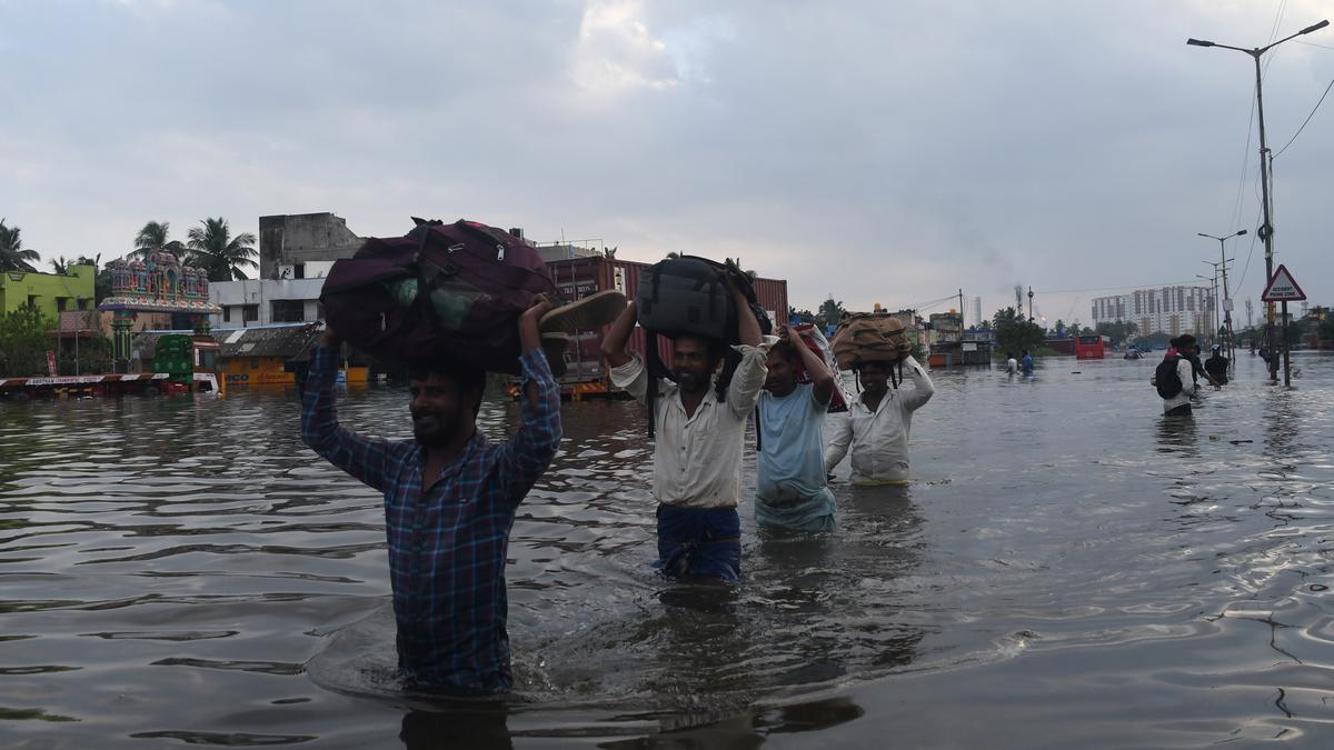
Flooding in Chennai, Tamil Nadu, on Tuesday 5 December 2023.  Jothi Ramalingam/The Hindu.

Tropical storms, called Cyclones in the Indian Ocean and South Pacific, are caused by solar energy heating the air above the oceans, which causes the air to rise leading to an inrush of air. If this happens over a large enough area the inrushing air will start to circulate, as the rotation of the Earth causes the winds closer to the equator to move eastwards compared to those further away (the Coriolis Effect). This leads to tropical storms rotating clockwise in the southern hemisphere and anticlockwise in the northern hemisphere. These storms tend to grow in strength as they move across the ocean and lose it as they pass over land (this is not completely true: many tropical storms peter out without reaching land due to wider atmospheric patterns), since the land tends to absorb solar energy while the sea reflects it.

The formation of a tropical cyclone. Natural Disaster Management.

Despite the obvious danger of winds of this speed, which can physically blow people, and other large objects, away as well as damaging buildings and uprooting trees, the real danger from these storms comes from the flooding they bring. Each drop millibar drop in air-pressure leads to an approximate 1 cm rise in sea level, with big tropical storms capable of causing a storm surge of several meters. This is always accompanied by heavy rainfall, since warm air over the ocean leads to evaporation of sea water, which is then carried with the storm. These combined often lead to catastrophic flooding in areas hit by tropical storms. 

The formation and impact of a storm surge. eSchoolToday.

See also...

Follow Sciency Thoughts on Facebook.

Follow Sciency Thoughts on Twitter.


Saturday, 23 April 2022

Sillago muktijoddhai & Sillago mengjialensis: Two new species of Sillago from Bangladesh.

Sillagos, Sillago spp., are inshore Perciform Fish widespread in the IndoPacific region. They form an important part of many food webs, feeding on Crustaceans and Molluscs in coastal waters or estuarine areas of rivers with open sandflats and muddy substrates, and in turn being fed upon by larger Fish, Marine Mammals, and Seabirds. Understanding the population structure of these Fish has proven difficult, as the genus contains a large number of very similar-appearing species, often identifiable only by the structure of their swim bladders, with the recent application of genetic profiling to the group suggesting that even this is not reliable, and that the group may contain more cryptic species (species which cannot easily be told apart by physical examination) than previously realised.

In a paper published in the journal Fishes on 18 April 2022, Shilpi Saha of the Fisheries College at the Ocean University of China, and the Department of Zoology at Jagannath University, Na Song and Zhengsen Yu, also of the Fisheries College at the Ocean University of China, Mohammad Abdul Baki, also of the Department of Zoology at Jagannath University, Roland McKay of the Chillagoe Museum, Jianguang Qin of the School of Biological Sciences at Flinders University, and Tianxiang Gao of the Fishery College at the Zhejiang Ocean University, describe two new species of Sillago from Bangladesh.

The new species are described from specimens obtained from fishermen at locations in Cox’s Bazar, Sundarbans, Patharghata, Maheshkhali and Saint Martin’s Island. These Fish are typically caught using beach seine nets in this area.

The first new species described is named Sillago muktijoddhai, were 'muktijoddhai' refers to the muktijoddha freedom fighters who fought for Bangladesh's independence from Pakistan from 1971 to 1979. 

Sillago muktijoddhai is elongated in shape, slightly steep anteriorly, and tubular posteriorly. The upper jaw is slightly protracted and crescentic, with minute villiform teeth on both jaws in one row. The back edge of the preopercle is slightly denticulated, and the opercle has one fragile spine posterodorsally. Gill rakers on the first arch are pointed and gradually become short towards the end. The body is covered with moderate-sized, overlapping ctenoid scales. The cheek scales cycloid, arranged in two rows.

There are two distinctly separate dorsal fins. The first dorsal fin is higher than the second, originating above the pectoral-fin base; its second spine is the longest, and the length of the succeeding spines decrease gradually. The base of the second dorsal fin is long, beginning at the midbody and not reaching the caudal-fin base when depressed. The anal fin originates slightly posterior to the anus, not reaching the caudal-fin base when depressed. The two disconnected pelvic fins are wide, roughly three-cornered, and shorter than the pectoral fin.

The body of Sillago muktijoddhai is greenish dorsally and light yellowish ventrally with black dots on the side below the lateral line. The cheek has black dots gathered on the anteroventral part of the eyes. The dorsal fins are hyaline, and small dark spots exist on the fin membrane, but those on the second dorsal fin form two or three distinct rows. The pectoral and pelvic fins are light yellowish. The anal fin is light yellowish with black spots. The caudal fin is light yellowish, dusky, and with a white edge; the lobes are truncated or emarginated.

Sillago muktijoddhai from the Bay of Bengal, Bangladesh. Saha et al. (2022).

The second new species is named Sillago mengjialensis, where 'mengjialensis' means 'from Mèngjiālā', where Mèngjiālā is the Chinese name for Bengal, in reference to the fact that the species was discovered as part of a collaborative project between scientists from China and Bangladesh.

The body of Sillago mengjialensis is elongated, somewhat conical anteriorly, and cylindric posteriorly. The back edge of the preopercle is slightly toothed. The opercle only has one weak spine posterodorsally. The gill rakers on the first arch are pointed and gradually become small towards the end. The body is covered with moderate-sized, overlapping ctenoid scales. The cheek scales are cycloid, arranged in two rows.

There are two disconnected dorsal fins. The first dorsal fin is higher than the second, originating above the pectoral fin base; its second spine is the longest, and the length of the succeeding spines decreases gradually. The base of the second dorsal fin is long, beginning at the midbody, and not reaching the caudal-fin base when depressed. The anal fin originates slightly posterior to the anus, not reaching the caudal-fin base when depressed. Two disconnected pelvic fins are large, roughly trigonal in shape, and smaller than the pectoral fin.

The body of Sillago mengjialensis is light olive greenish dorsally and silver ventrally with black spots on the sides below the lateral line. The cheek has black spots gathered on the anteroventral part of the eyes. The dorsal fins are hyaline with small dark spots on the fin membrane adjacent to the ray. The pectoral and pelvic fins are light yellowish. The anal fin is light yellowish to whitish with black dots. The caudal fin light yellowish, dusky, and has a white margin; the lobes are truncated or emarginated.

 
Sillago mengjialensis from the Bay of Bengal, Bangladesh. Saha et al. (2022).

See also...


Follow Sciency Thoughts on Facebook.

Follow Sciency Thoughts on Twitter.


Thursday, 21 May 2020

Cyclone Amphan kills at least 87 in India and Bangladesh.

At least 87 people have died in India and Bangladesh after Cyclone Amphan made landfall in the Indian State of West Bengal on Wednesday 20 May 2020, bringing with it winds at speeds of up to185 km per hour and a storm surge 4 m high. The majority of the deaths have occurred in West Bengal, where 72 people are known to have died, with a further twelve recorded deaths in Bangladesh and three in the Indian state of Odisha. Kolkata alone has suffered twelve known fatalities, as well as widespread flooding in low-lying parts of the city, and widespread power failures. The districts of North 24 Parganas, South 24 Parganas, and Minakha districts are reported to have suffered widespread devastation, with widespread flooding and tens of thousands of homes destroyed. In Bangladesh around half a million people are reported to have been made homeless and around five million have lost electricity. The number of deaths is thought to have been greatly reduced by the evacuation of around 2.4 million people from low-lying areas in Bangladesh and about 650 000 people from low-lying areas in West Bengal and Odisha.

Flooding in Bangladesh as Cyclone Amphan made landfall on Wednesday 20 May 2020. Xinhua.

Tropical storms, called Cyclones in the Indian Ocean and South Pacific, are caused by solar energy heating the air above the oceans, which causes the air to rise leading to an inrush of air. If this happens over a large enough area the inrushing air will start to circulate, as the rotation of the Earth causes the winds closer to the equator to move eastwards compared to those further away (the Coriolis Effect). This leads to tropical storms rotating clockwise in the southern hemisphere and anticlockwise in the northern hemisphere. These storms tend to grow in strength as they move across the ocean and lose it as they pass over land (this is not completely true: many tropical storms peter out without reaching land due to wider atmospheric patterns), since the land tends to absorb solar energy while the sea reflects it.

 A house destroyed by a falling tree in Nadia District, West Bengal, during the passage of Cyclone Amphan. PTI.

Despite the obvious danger of winds of this speed, which can physically blow people, and other large objects, away as well as damaging buildings and uprooting trees, the real danger from these storms comes from the flooding they bring. Each drop millibar drop in air-pressure leads to an approximate 1 cm rise in sea level, with big tropical storms capable of causing a storm surge of several meters. This is always accompanied by heavy rainfall, since warm air over the ocean leads to evaporation of sea water, which is then carried with the storm. These combined often lead to catastrophic flooding in areas hit by tropical storms.

Damage in Kolkata following the passage of Cyclone Amphan on 20 May 2020. Sandipan Chatterjee/Outlook India,

See also...
 
https://sciencythoughts.blogspot.com/2020/04/landlide-kills-three-workers-at-quarry.htmlhttps://sciencythoughts.blogspot.com/2019/10/collapse-at-illegal-coal-mine-traps.html
https://sciencythoughts.blogspot.com/2019/09/landslide-kills-two-children-in-coxs.htmlhttps://sciencythoughts.blogspot.com/2019/08/leopard-attack-thwarted-by-dog-in.html
https://sciencythoughts.blogspot.com/2019/07/flooding-kills-more-than-30-people-in.htmlhttps://sciencythoughts.blogspot.com/2019/05/cyclone-fani-kills-at-least-28-in-india.html
Follow Sciency Thoughts on Facebook.

Sunday, 5 May 2019

Cyclone Fani kills at least 28 in India and Bangladesh.

Cyclone Fani is reported to have caused 28 known fatalities in India and Bangladesh after making landfall in Odisha State, India, on Friday 3 May 2019. The majority of the deaths occurred in Odisha, where the storm was the largest to come ashore since the un-named storm of 1999, which killed over a thousand people, prompting India to initiate a program of mass-evacuations of low-lying coastal areas when large storms approach. On this occasion around 1.2 million people were evacuated from their homes in the 24 hours before the storm made landfall, though 16 people still lost their lives, with about 160 being injured, with the extensive storm damage reported in coastal areas, particularly around the town of Puri, close to where Fani made landfall, and in the state capital, Bhubaneswar. After hitting Odisha the storm veered to the northeast, making landfall in Bangladesh were 12 people were killed despite an evacuation of 1.6 million.

Storm damage in the town of Puri in Odisha, following the passage of Cyclone Fani. Dibyangshu Sarkar/AFP/Getty Images.

Tropical storms, called Cyclones in the Indian Ocean, are caused by solar energy heating the air above the oceans, which causes the air to rise leading to an inrush of air. If this happens over a large enough area the inrushing air will start to circulate, as the rotation of the Earth causes the winds closer to the equator to move eastwards compared to those further away (the Coriolis Effect). This leads to tropical storms rotating clockwise in the southern hemisphere and anticlockwise in the northern hemisphere.These storms tend to grow in strength as they move across the ocean and lose it as they pass over land (this is not completely true: many tropical storms peter out without reaching land due to wider atmospheric patterns), since the land tends to absorb solar energy while the sea reflects it.

 Damage to the railway station in Puri following the passage of Cyclone Fani. Partha Paul/Indian Express.

Despite the obvious danger of winds of this speed, which can physically blow people, and other large objects, away as well as damaging buildings and uprooting trees, the real danger from these storms comes from the flooding they bring. Each drop millibar drop in air-pressure leads to an approximate 1 cm rise in sea level, with big tropical storms capable of causing a storm surge of several meters. This is always accompanied by heavy rainfall, since warm air over the ocean leads to evaporation of sea water, which is then carried with the storm. These combined often lead to catastrophic flooding in areas hit by tropical storms.

See also...

https://sciencythoughts.blogspot.com/2018/10/woman-attacked-by-crocodile-in-odisha.htmlhttps://sciencythoughts.blogspot.com/2018/04/crocodile-kills-fourteen-year-old-boy.html
https://sciencythoughts.blogspot.com/2017/11/woman-killed-in-landslide-at-illegal.htmlhttps://sciencythoughts.blogspot.com/2017/10/elephants-kill-four-rohingya-refugees.html
https://sciencythoughts.blogspot.com/2016/10/identifying-cause-of-2016-bangladesh.htmlhttps://sciencythoughts.blogspot.com/2015/08/death-toll-thought-to-have-exceeded-120.html


Follow Sciency Thoughts on Facebook.

Saturday, 16 June 2018

Eight dead and five missing following landslide in Kozhikode District, Kerala.

Eight people, including four children, have been confirmed dead and another five are still missing, following a landslide which hit the village of Kattipara in Kozhikode District, Kerala, on Thursday 14 Jube 2018. The deceased have been named as Dilna, 13, Muhammad Shahabad, 7, Abdur Rahman, 60, Jannat, 25, Muhammad Jaseem, 5, Hassan, 67 and Jaffar, 45 and Rippa Mariam, 1½. The landslide is thought to have been caused by heavy rains associated with the Southwest Monsoon, which arrived in Kerala about six weeks ago, and brings the number of deaths attributed to flooding and landslides associated with the monsoon in the state this year to 43.

Rescue workers looking for survivors following a landslide that hit the village of Kattipara in Kozhikode District, Kerala, on 14 June 2018. Press Trust of India.

Monsoons are tropical sea breezes triggered by heating of the land during the warmer part of the year (summer). Both the land and sea are warmed by the Sun, but the land has a lower ability to absorb heat, radiating it back so that the air above landmasses becomes significantly warmer than that over the sea, causing the air above the land to rise and drawing in water from over the sea; since this has also been warmed it carries a high evaporated water content, and brings with it heavy rainfall. In the tropical dry season the situation is reversed, as the air over the land cools more rapidly with the seasons, leading to warmer air over the sea, and thus breezes moving from the shore to the sea (where air is rising more rapidly) and a drying of the climate.

 Diagrammatic representation of wind and rainfall patterns in a tropical monsoon climate. Geosciences/University of Arizona.

Kerala has a complex seasonal cycle, driven by the presence of the Western Ghats mountain range, which largely block the dry northerly winds which dominate the climate of much of India, and its proximity to the equator, which leads to a double monsoon system. Such a double Monsoon Season is common close to the equator, where the Sun is highest overhead around the equinoxes and lowest on the horizons around the solstices, making the solstices the coolest part of the year and the equinoxes the hottest. In Kerala this results in a Southwest Monsoon, which lasts from May to September, and is driven by winds from the southern Arabian Sea dumping water onto the Western Ghats, followed by a Northwest Monsoon, which lasts from October to December, where winds from the Bay of Bengal do the same. Of the two monsoons, the southwest is the wetter, due to the proximity of the sea, with June typically being the wettest month, with an average of 341 mm of rain falling in the month.

Flooding below the village of Kattipara in the Thamarassery Churam mountain passage in Kerala State, India. ANI.

See also...

http://sciencythoughts.blogspot.com/2018/05/eleven-confirmed-fatalities-in-nipah.htmlhttp://sciencythoughts.blogspot.com/2017/12/twenty-two-confirmed-deaths-as-cyclone.html
http://sciencythoughts.blogspot.com/2013/08/a-least-five-dead-following-landslide.htmlhttp://sciencythoughts.blogspot.com/2013/06/man-killed-in-kerala-landslide.html
Follow Scieny Thoughts on Facebook.