Showing posts with label Central American Arc. Show all posts

Monday, 24 April 2023

Eruption on Rincón de la Vieja volcano, Costa Rica.

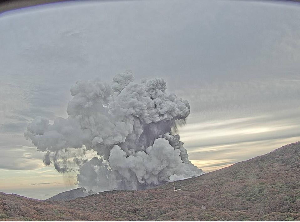
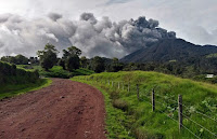
The Comisión Nacional de Emergencias in Costa Rica has reported a large eruption on Rincón de la Vieja, an active volcano in Guanacaste Province.in the northwest of the country, on Friday 21 April 2023. The volcano produced an ash column about 7.5 km high, and part of the northern perimeter of the volcano's caldera was breached, causing ash-laden waters from the volcano's lake to escape, and triggering a series of lahars along the courses of the Pénjamo, Azúl and Azufrada rivers. This event is not thought to have caused any injuries or damage to infrastructure, but people are being warned to keep away from the affected waterways.

An ash column over the Rincon de La Vieja volcano, Costa Rica, on 21 April 2023. Observatorio Vulcanológico y Sismológico de Costa Rica-Universidad Nacional.

Rincón de la Vieja is a complex volcano (volcano with multiple eruptive vents rather than a single crater at the top of a cone-shaped mountain) rising to 1916 m above sea-level in Guanacaste Province in the northwest of Costa Rica. It is located within the Rincón de la Vieja National Park, where along with an associated hot spring system it forms an important part of the local economy. Prior to the onset of activity in September 2014 the volcano had been inactive since September 2011, and the last major eruption occurred in 1966. A small geothermal energy project, the Las Pailas Geothermal Power Plant, runs on heat from underground rocks associated with the volcanic complex.

Rincón de la Vieja forms part of the Cordillera de Guanacaste, a range of volcanic mountains running through northern Costa Rica close to the border with Nicaragua and forming part of the Central American Arc. These volcanoes are fueled by the subduction of the Cocos Plate, which underlies part of the east Pacific Ocean, beneath the Caribbean Plate, on which Central America lies, along the Middle American Trench, which lies off the south coast of the country. As the Cocos Plate is subducted it is gradually melted by the heat and pressure of the Earth's interior, with some more volatile minerals rising through the overlying Caribbean Plate as volcanic magma.

Diagram showing the passage of the Cocos Plate beneath Costa Rica (not to scale). Carleton College.

See also...

Follow Sciency Thoughts on Facebook.

Follow Sciency Thoughts on Twitter


Tuesday, 1 October 2019

Eruption on Mount Poás, central Costa Rica.

Mount Poás, a 2708 m stratovolcano (volcano with a classic cone-shape, which is made from the build up of layers of ash and lava) in central Costa Rica, erupted at about 5.40 am local time on Monday 30 September 2019, producing a column of ash and debris about 2 km high. The volcano had been quiet since February this year, and Poás Volcano National Park, a popular tourist attraction centred on the volcano, had been re-opened to the public in August, but on Sunday 22 September underwent a significant degassing episode, which appears to have marked the onset of a new volcanic phase, and which prompted the closure of the national park until further notice.

Eruption on Mount Poás on 30 September 2019. Comisión Nacional de Emergencias.

Mount Poás rises to 2708 m above sea level, but has gently sloping, forested flanks making the summit easily accessible. The summit consists of two craters, each with a lake. To the south is the cool, clear, Lake Botos, which has not seen an eruption for 7500 years, and to the north is Laguna Caliente, which is thermally heated, extremely acidic (about pH 0), and prone to frequent eruptions. The volcano and its surrounding area form the Poás Volcano National Park.

Mount Poás forms part of the Cordillera Central, a range of volcanic mountains running through central Costa Rica and forming part of the Central American Arc. These volcanoes are fuelled by the subduction of the Cocos Plate, which underlies part of the east Pacific Ocean, beneath the Caribbean Plate, on which Central America lies, along the Middle American Trench, which lies off the south coast of the country. As the Cocos Plate is subducted it is gradually melted by the heat and pressure of the Earth's interior, with some more volatile minerals rising through the overlying Caribbean Plate as volcanic magma.

 Diagram showing the passage of the Cocos Plate beneath Costa Rica (not to scale). Carleton College.

See also...

http://sciencythoughts.blogspot.com/2019/09/magnitude-48-earthquake-on-caribbean.htmlhttps://sciencythoughts.blogspot.com/2018/04/magnitude-41-earthquake-in-san-jose.html
http://sciencythoughts.blogspot.co.uk/2018/02/eruption-on-mount-turrialba.htmlhttp://sciencythoughts.blogspot.co.uk/2018/01/magnitude-59-earthquake-off-coast-of.html
http://sciencythoughts.blogspot.co.uk/2017/12/american-tourist-killed-by-shark-in.htmlhttp://sciencythoughts.blogspot.co.uk/2017/09/magnitude-53-earthquake-on-nicoya.html
Follow Sciency Thoughts on Facebook.

Friday, 9 February 2018

Eruption on Mount Turrialba.

The University of Costa Rica’s National Seismological Network has reported a large eruption on Mount Turrialba, a 3340 stratovolcano (cone-shaped volcano made up of layers of ash and lava), in the central part of the country, on the morning of Tuesday 6 February 2018, which produced a column of ash that rose over a kilometer above the summit of the volcano. Turrialba has been more-or-less constantly active since December 2016, but this is the first eruption of 2018 to produce an eruptive column more than 500 m high.

Eruption on Mount Turrialba on Tuesday 6 February 2018. Red Sismológica Nacional/Universidad de Costa Rica.

Turrialba forms part of the Cordillera Central, a range of volcanic mountains running through central Costa Rica and forming part of the Central American Arc. These volcanoes are fuelled by the subduction of the Cocos Plate, which underlies part of the east Pacific Ocean, beneath the Caribbean Plate, on which Central America lies, along the Middle American Trench, which lies off the south coast of the country. As the Cocos Plate is subducted it is gradually melted by the heat and pressure of the Earth's interior, with some more volatile minerals rising through the overlying Caribbean Plate as volcanic magma.

 Diagram showing the passage of the Cocos Plate beneath Costa Rica (not to scale). Carleton College.

See also...

http://sciencythoughts.blogspot.co.uk/2018/01/magnitude-59-earthquake-off-coast-of.htmlhttp://sciencythoughts.blogspot.co.uk/2017/12/american-tourist-killed-by-shark-in.html
http://sciencythoughts.blogspot.co.uk/2017/09/magnitude-53-earthquake-on-nicoya.htmlhttp://sciencythoughts.blogspot.co.uk/2017/08/magnitude-48-earthquake-off-soth-coast.html
http://sciencythoughts.blogspot.co.uk/2017/04/access-to-mount-poas-costa-rica-closed.htmlhttp://sciencythoughts.blogspot.co.uk/2017/01/eruptions-on-mount-turrialba-costa-rica.html
Follow Sciency Thoughts on Facebook.

Tuesday, 18 April 2017

Access to Mount Poás, Costa Rica, closed off following eruptions.

Tourist access to Mount Poás, a stratovolcano (cone-shaped volcano made up of layers of ash and lava) in central Costa Rica, has been closed off following a series of eruptions over the weekend of 15-16 April 2017. The two largest eruptions occurred between 8.40 and 9.00 am on Sunday 16 April, producing an ash column about a kilometre high and throwing rocks over a kilometre from the summit, some falling onto viewpoints from which tourists can observe the volcano.

Rock embedded into the concrete of a viewing point near Mount Poás following the 18 April 2017 eruption. Redy Conejo/Poás Volcano National Park.

Mount Poás rises to 2708 m above sea level, but has gently sloping, forested flanks making the summit easily accessible. The summit consists of two craters, each with a lake. To the south is the cool, clear, Lake Botos, which has not seen an eruption for 7500 years, and to the north is Laguna Caliente, which is thermally heated, extremely acidic (about pH 0), and prone to frequent eruptions. The volcano and its surrounding area form the Poás Volcano National Park.

Ash column over Mount Poás following an eruption on 14 April 2016. Observatorio Vulcanológico y Sismológico de Costa Rica.

Mount Poás forms part of the Cordillera Central, a range of volcanic mountains running through central Costa Rica and forming part of the Central American Arc. These volcanoes are fuelled by the subduction of the Cocos Plate, which underlies part of the east Pacific Ocean, beneath the Caribbean Plate, on which Central America lies, along the Middle American Trench, which lies off the south coast of the country. As the Cocos Plate is subducted it is gradually melted by the heat and pressure of the Earth's interior, with some more volatile minerals rising through the overlying Caribbean Plate as volcanic magma.

Diagram showing the passage of the Cocos Plate beneath Costa Rica (not to scale). Carleton College.

See also...

http://sciencythoughts.blogspot.co.uk/2017/01/eruptions-on-mount-turrialba-costa-rica.htmlhttp://sciencythoughts.blogspot.co.uk/2016/09/airports-closed-after-eruptions-on.html
http://sciencythoughts.blogspot.co.uk/2016/07/magnitude-53-earthquake-in-guanacaste.htmlhttp://sciencythoughts.blogspot.co.uk/2016/05/eruptions-on-mount-turrialba.html
http://sciencythoughts.blogspot.co.uk/2016/05/exclusion-zone-established-around-mount.htmlhttp://sciencythoughts.blogspot.co.uk/2016/03/eruption-on-rincon-de-la-vieja-costa.html
Follow Sciency Thoughts on Facebook.

Sunday, 1 January 2017

Eruptions on Mount Turrialba, Costa Rica.

Mount Turrialba in central Costa Rica came back to life on Wednesday 28 December, having been inactive since the middle of the month. Since then the University of Costa Rica’s National Seismological Network has detected more or less constant seismic activity (tremors) below the volcano combined with a series of small (and not so small) eruptions, including large events at 11.00 pm on Thursday 29 December and 3.35 and 8.00 am on Friday 30 December, the largest of these producing an ash column that rose 300 m above the summit of the mountain.

Eruption on Mount Turrialba on Friday 30 December 2016. Red Sismológica Nacional/Universidad de Costa Rica.

Turrialba forms part of the Cordillera Central, a range of volcanic mountains running through central Costa Rica and forming part of the Central American Arc. These volcanoes are fuelled by the subduction of the Cocos Plate, which underlies part of the east Pacific Ocean, beneath the Caribbean Plate, on which Central America lies, along the Middle American Trench, which lies off the south coast of the country. As the Cocos Plate is subducted it is gradually melted by the heat and pressure of the Earth's interior, with some more volatile minerals rising through the overlying Caribbean Plate as volcanic magma.

  Diagram showing the passage of the Cocos Plate beneath Costa Rica (not to scale). Carleton College.

See also...


http://sciencythoughts.blogspot.co.uk/2016/07/magnitude-53-earthquake-in-guanacaste.html
http://sciencythoughts.blogspot.co.uk/2016/09/airports-closed-after-eruptions-on.html


http://sciencythoughts.blogspot.co.uk/2016/05/exclusion-zone-established-around-mount.html
http://sciencythoughts.blogspot.co.uk/2016/05/eruptions-on-mount-turrialba.html

http://sciencythoughts.blogspot.co.uk/2015/12/explosive-eruption-on-mount-turrialba.html
http://sciencythoughts.blogspot.co.uk/2016/03/eruption-on-rincon-de-la-vieja-costa.html


Follow Sciency Thoughts on Facebook.

Wednesday, 21 September 2016

Airports closed after eruptions on Mount Turrialba.

Several airports in Costa Rica were forced to close after a pair of eruptions on Mount Turrialba, a stratovolcano (cone shaped volcano made up of layers of ash and lava) in the central part of the country, Monday 19 September 2016. The first eruption occured at about dawn, the second at about noon, this latter event producing an ash column over four kilometers high, and causing ashfalls in the city of Cartago. A third eruption occured on Tuesday 20 September.

Eruption on Mount Turrialba on Monday 19 September 2016. Red Sismológica Nacional/Universidad de Costa Rica.

Volcanic ash is extremely hazardous to aircraft in a number of ways. At its most obvious it is opaque, both visually and to radar. Then it is abrasive, ash particles physically scour aircraft, damaging components and frosting windows. However the ash is most dangerous when it is sucked into jet engines, here the high temperatures can melt the tiny silica particles, forming volcanic glass which then clogs engine. When this happens the only hope the aircraft has is to dive sharply, in the hope that cold air passing through the engine during the descent will cause the glass to shatter, allowing the engine to be restarted.

 Residents of Cartago during an ashfall event on Monday 19 September 2016. AFP.

Turrialba forms part of the Cordillera Central, a range of volcanic mountains running through central Costa Rica and forming part of the Central American Arc. These volcanoes are fueled by the subduction of the Cocos Plate, which underlies part of the east Pacific Ocean, beneath the Caribbean Plate, on which Central America lies, along the Middle American Trench, which lies off the south coast of the country. As the Cocos Plate is subducted it is gradually melted by the heat and pressure of the Earth's interior, with some more volatile minerals rising through the overlying Caribbean Plate as volcanic magma.

  Diagram showing the passage of the Cocos Plate beneath Costa Rica (not to scale). Carleton College.

See also...

http://sciencythoughts.blogspot.co.uk/2016/05/exclusion-zone-established-around-mount.htmlExclusion zone established around Mount Turriabla after a series of eruptions on Sunday 1 May 2016.                                    The Costa Rican Comisión Nacional de Emergencias has...
http://sciencythoughts.blogspot.co.uk/2016/05/eruptions-on-mount-turrialba.htmlEruptions on Mount Turrialba                         The Observatorio Vulcanológico y Sismológico de Costa Rica-Universidad Nacional reported a series of eruptions on Mount Turrialba, a stratovolcano (cone shaped volcano made up of layers of ash and lava) in the central part of...
http://sciencythoughts.blogspot.co.uk/2015/12/explosive-eruption-on-mount-turrialba.htmlExplosive eruption on Mount Turrialba. The Observatorio Vulcanológico y Sismológico de Costa Rica-Universidad Nacional reported a short explosive eruption which lasted about ten minutes, beginning slightly after 1.10 pm local time on Monday 7 December 2015...
 
Follow Sciency Thoughts on Facebook. 

Friday, 20 May 2016

Eruptions on Mount Turrialba

The Observatorio Vulcanológico y Sismológico de Costa Rica-Universidad Nacional reported a series of eruptions on Mount Turrialba, a stratovolcano (cone shaped volcano made up of layers of ash and lava) in the central part of the country, on Thursday 19 May 2016. The initial eruption occurred at about 2.05 pm local time, and produced a column of ash about a kilometer im height. This was followed by a second slightly after 3.45 and a third slightly before 4.10 pm. Ash from the volcano was blown to the southwest. 

Ash column over Mount Turrialba on 19 May 2016. Comisión Nacional de Emergencias.

The volcano has been undergoing continual of small eruptions since September 2014, although the last week has been particularly active, with a number of reports of ash accumulating in fields and rivers nearby. Ash deposits falling in or near waterways are considered to be particularly hazardous due to the danger of lahars, ash-laden flash floods associated with volcanoes. These are also common in areas of high seasonal rainfall, where ash deposits from a volcano can build up during the dry season, creating dams on seasonal waterways, which temporarily halt the flow of water, then give way rapidly leading to dramatic flash floods. However May marks the beggining of the riany season across much of Costa Rica, and the increased rainfall appears to be washing much of the ash away before it can form hazardous dams.

Ashfall on pasture and woodland near Mount Turriabla. Comisión Nacional de Emergencias.

Turrialba forms part of the Cordillera Central, a range of volcanic mountains running through central Costa Rica and forming part of the Central American Arc. These volcanoes are fueled by the subduction of the Cocos Plate, which underlies part of the east Pacific Ocean, beneath the Caribbean Plate, on which Central America lies, along the Middle American Trench, which lies off the south coast of the country. As the Cocos Plate is subducted it is gradually melted by the heat and pressure of the Earth's interior, with some more volatile minerals rising through the overlying Caribbean Plate as volcanic magma.

Diagram showing the passage of the Cocos Plate beneath Costa Rica (not to scale). Carleton College.

See also...

http://sciencythoughts.blogspot.co.uk/2016/05/exclusion-zone-established-around-mount.htmlExclusion zone established around Mount Turriabla after a series of eruptions on Sunday 1 May 2016.                                                 The Costa Rican Comisión Nacional de Emergencias has...
http://sciencythoughts.blogspot.co.uk/2016/03/eruption-on-rincon-de-la-vieja-costa.htmlEruption on Rincón de la Vieja, Costa Rica. The Observatorio Vulcanológico y Sismológico de Costa Rica-Universidad Nacional reported a small eruption on Rincón de la Vieja, an active volcano in the northwest of the country, at about 4.20 pm local time on Tuesday 15 March...
http://sciencythoughts.blogspot.co.uk/2015/12/explosive-eruption-on-mount-turrialba.htmlExplosive eruption on Mount Turrialba. The Observatorio Vulcanológico y Sismológico de Costa Rica-Universidad Nacional reported a short explosive eruption which lasted about ten minutes, beginning slightly after 1.10 pm local time on Monday 7 December 2015...

Follow Sciency Thoughts on Facebook.