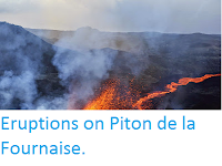
The Observatoire Volcanologique du Piton de la Fournaise
reported an eruption on Piton de la
Fournaise, an active volcano on Réunion Island, an overseas department
of France in the Indian Ocean, on Friday 27 April 2018. Seismic activity beneath the volcano began to increase sharply at about 8.15 pm local time, followed by an eruption that started at about 11.50 pm. This has been accompanied by the opening of an eruptive fissure on the southern flank of the volcano. Access to the summit of the volcano, which is home to several popular tourist trails, has been closed off due to concerns about the possibility of a collapse, and the Toulouse Volcanic Ash Advisory Centre has issued a warning to aviation in the area.

Eruption on Piton de la Fournaise on 27 April 2018. Préfet de La Réunion/Twitter.
Piton
de la Fournaise is believed to have been active for about 530 000
years, though its geology is complicated to unravel as lava flows are
interbedded with those from Piton des Neiges, a larger, older and now
extinct volcano to the northwest, which is responsible for the formation
of about two thirds of the island. The island sits on the Réunion
Hotspot, a deep mantle plume which is thought to have been active for
about 66 million years, originally forming under what is now
northeastern India, where it was responsible for the Deccan Traps flood
basalts, then moving southward across the Indian Ocean (or more
precisely sitting still while the continental plate upon which India and
the Indian Ocean sit moves to the north), over time forming the
Laccadive Islands, the Maldives, the Seychelles, Rodrigues Island,
Mauritius and Réunion.

See also...


Follow Sciency Thoughts on Facebook.