Showing posts with label Mongolia. Show all posts

Tuesday, 21 November 2023

Jaculinykus yaruui: A new species of Alvarezsaurid Dinosaur from the Late Cretaceous of Mongolia.

The Alvarezsaurids are a poorly understood group of Maniraptoran Theropod Dinosaurs, in which later members became miniaturized and independently obtained a number of features associated with Birds, including s a lightly built, kinetic skull, a keeled sternum, a fused carpometacarpus, and a retroverted pubis and ischium. This was combined with several features unique to the group which have been hard to interpret functionally, including a short robust forelimb with a greatly elongated first finger, which has been suggested as a possible adaptation to digging and hunting burrowing Insects, combined with elongate hind limbs, apparently adapted to fast running. It has also been suggested that the group show adaptations towards vision in low-light environments and highly acute hearing, possibly comparable to that of modern Barn Owls, which is likely an indication of nocturnal behaviour.  

The Alvarezsaurids had a global distribution, but the majority of fossils are known from South America or Asia. The most derived Alvarezsaurids are known from the Late Cretaceous Nemegt Basin of Mongolia, from where eight species have been described to date, although most of these are known from fragmentary remains, of little help in reconstructing the ecology of the living Dinosaurs, or the way in which they were related to one-another.

In a paper published in the journal PLoS One on 15 November 2023, Kohta Kubo of the Department of Natural History and Planetary Sciences at Hokkaido University, Yoshitsugu Kobayashi of the Hokkaido University Museum, Tsogtbaatar Chinzorig of the Department of Biological Sciences at North Carolina State University and the Institute of Paleontology of the Mongolian Academy of Sciences, and Khishigjav Tsogtbaatar, also of the Institute of Paleontology of the Mongolian Academy of Sciences, describe a new species of Alvarezsaurid Dinosaur from the Nemegt Basin.

The new species is described from a single nearly complete and articulated skeleton, from the Baruungoyot-Nemegt interfingering interval at the Nemegt locality of the Nemegt Basin in the Gobi Desert of Mongolia. It is named Jaculinykus yaruui, where 'Jaculinykus' is a combination of 'Jaculus' a small Dragon from Greek mythology, and 'onykus', meaning 'claw', while 'yaruui'- derives from the Mongolian word 'yaruu', meaning 'speedy'.

Holotype of Jaculinykus yaruui (MPC-D 100/209). (A) Photograph of the specimen. (B) Explanatory drawing of (A). Highlighted areas refer to the indication of the skeletal elements; skull in green, tail in grey, pectoral girdle and forelimbs in red, pelvis and hind limbs in purple. (C) Reconstruction of Jaculinykus yaruui. Grey areas are missing parts. Kubo et al. (2023).

The specimen comprises is a nearly complete skeleton with a skull, missing the vomers, nasals, postorbitals, and supraoccipitals, and a post-cranial skeleton missing the eighth or ninth cervical vertebra, posterior dorsal vertebrae, seven anterior caudal vertebrae, sternum, furcula, right manual phalanx (II-2), right manual ungual and left fibula. 

Surprisingly, it was discovered with the neck curved posteriorly on the right side of the body; the tail positioned on the left side and curled around the flexed hind limbs to the right. This is very different from the typical 'flexed' position seen in small Theropod Dinosaur remains, and closely resembles the sleeping posture in Birds, where the head is tucked under the wing. Such a posture has previously been recorded in numerous Troodontids, Dinosaurs closely related to Birds. However, Alvarezsaurids are much less closely related within the Maniraptora. This raises two possibilities; either this sleeping posture arose before or with the emergence of the first Maniraptorans, and can be expected in all members of the group, or is a convergent adaptation to heat conservation in sleeping small feathered Dinosaurs.

Evolution of Avian-like sleeping posture in Theropod Dinosaurs. Skeletal disposition of Jaculinykus yaruui  (MPC-D 100/209) in dorsal (A) and ventral (reversed) (B) views. (C), Interpretive line drawing of skeletal disposition. (D), Life restoration of sleeping posture of Jaculinykus yaruui . (E), Simplified coelurosaurian phylogeny represents presence for evidence of avian ‘tuck-in’ posture. Kubo et al. (2023).

See also...

Online courses in Palaeontology. 

Follow Sciency Thoughts on Facebook.

Follow Sciency Thoughts on Twitter.


Saturday, 24 June 2023

Shri devi: The (previously unknown) skull of a Dromaeosaurid Dinosaur from the Late Cretaceous Baruungoyot strata of Mongolia.

The Dromaeosaurs were a group of small-to-medium sized Theropod Dinosaurs, closely related to the earliest Birds. They are noted for the presence of an enlarged and highly curved claw on their second toe, a long, straight tail formed from tightly interlocked caudal vertebrae, and the presence of feathers. The group were widespread, with numerous fossils from the Cretaceous of Asia, North and South America, and Europe, although their Bird-like, often delicate skeletons did not usually preserve well, so most species are known only from fragmentary remains. One area where more complete Dromaeosaur skeletons are more frequently found is the Djadokhta strata of the Gobi Desert, Mongolia, an area which has produced several fairly complete skeletons of the Late Cretaceous Dromaeosaur, Velociraptor mongoliensis. 

These Upper Cretaceous deposits of the Gobi desert have produced a range of other Velociraptorine Dromaeosaurs, including Adasaurus mongoliensis, Tsaagan mangas, 'Velociraptor' osmolskae, Linheraptor exquisitus, Shri devi, and Kuru kulla, although most of these are known only from a single specimen.

In a paper published in the journal Acta Paleontologica Polonica on 21 June 2023, Łukasz Czepiński of the  Institute of Palaeobiology of the Polish Academy of Sciences, describes a new Dromaeosaur specimen from the Late Cretaceous Baruungoyot strata  of the Gobi Desert, which he assigns to the species Shri devi.

The new specimen, ZPAL MgD-I/97, was collected in 1970 by a Polish-Mongolian Palaeontological Expedition, and initially described and illustrated as Velociraptor sp., then later redescribed as a specimen of Velociraptor mongoliensis. However, upon re-examination of the specimen, Czepiński disagrees with this diagnosis, noting that the skull is much less elongated than in that species.

(A) Map of Mongolia and Inner Mongolia of China with the Upper Cretaceous sites yielding remains of dromaeosaurid dinosaurs. (B) Photograph of Khulsan locality, from where the specimen described in this paper was collected, photographed in the 1970 during the Polish-Mongolian Paleontological Expeditions (from the Collections of the Institute of Palaeobiology of the Polish Academy of Sciences). Czepiński (2023).

Specimen ZPAL MgD-I/97 comprises a partial skull, including the left jugal, left lacrimal, left maxilla, fragment of the right maxilla, palatine elements, both dentaries lacking the anteriormost portions, both splenials, surangulars, and angulars, in close association with a distal portion of the left hindlimb, containing the distal parts of the left fibula and tibia, astragalus and complete pes, with four metatarsals and all phalanges. The holotype specimen of Shri devi, MPC-D 100/980, is a partial articulated skeleton including cervical, dorsal, and proximal caudal vertebrae, the right femur, the right and left tibiotarsa, and the right pes but lacking a skull, There is almost no overlap in the bones of the two specimens, with ZPAL MgD-I/97 being about 20% smaller than MPC-D 100/980, but both specimens preserve a single hind foot (left in ZPAL MgD-I/97 and right in MPC-D 100/980), and Czepiński is confident that these are similar enough to assign the two specimens to the same species.

Reconstruction of the Dromaeosaurid Dinosaur Shri devi, based on ZPAL MgD-I/97 and MPC-D 100/980. (A) Skull; missing elements reconstructed on the base of Velociraptor mongoliensis (MPC-D 100/25 and MPC-D 100/54). (B) Whole body silhouette with known remains of the holotype and referred material. Czepiński (2023).

The skull of Shri devi is apparently much shorter than in other Mongolian Dromaeosaurids, based upon the shape of the antorbital fenestra (opening in the skull in front of the eye), which is almost round in Shri devi, but elongated in most Mongolian Dromaeosaurids, despite Shri devi otherwise being very similar, and presumably closely related to, Velociraptor mongoliensis. A similar short-snouted condition is seen in many North American Dromaeosaurids, though these are not thought to be closely related to Shri devi, suggesting that this is an ecological adaptation, rather than an indicator of relatedness.

Dromaeosaurid Dinosaur Shri devi (ZPAL MgD-I/97) from the Upper Cretaceous, Khulsan, Ömnögovi, Gobi Desert, Mongolia. Photographs (A₁), (A₂), (A₄), and (A₅) and 3D model (A₃), (A₆), and (A₇) obtained from the CT scan of the left side of the skull in dorsal (A₁), medial (A₂, A₃), anterior (A₆), and lateral (A₇) views. Elements of the left palate in dorsal (A₄) and ventral (A₅) views. Right maxilla in the lateral (A₈, A₉) and anterior (A₁₀) views, with the margin of the antorbital fenestra indicated by dashed lines, and the close up of the fifth (A₁₁) and the second (A₁₂) preserved tooth in labial views showing very weakly developed denticles on the mesial carina. Right mandible in the lateral (A₁₃) and (A₁₄) and medial (A₁₅) and (A₁₆) views. (B) Explanatory drawings of the skull in left (B₁) and right (B₂) lateral views with the preserved bones (in grey). Czepiński (2023).

Most of the Dromaeosaurid Dinosaurs from Mongolia, particularly those with very long snouts, are found in palaeodesert environments, covered by aeolian sands. Both specimens of Shri devi, on the other hand, comes from a more mixed environment, with a mixture of aeolian and fluvial deposits, suggesting a wetter (though still fairly arid) environment. The available prey to a small predatory Dinosaur would appear to have been similar in both environments, including Lizards, Mammals, Protoceratopsids, Oviraptorosaurs, and Birds (larger Ankylosaurids were also present, but unlikely to have been hunted by small Dromaeosaurs), suggesting that the variation in snout length is unlikely to be related to feeding. Instead, Czepiński suggests that an elongated snout may have been related to an elongated sinus, something which would have improved thermoregulation in Dromaeosaurs living in exposed, arid environments.

See also...

Online courses in Palaeontology. 

Follow Sciency Thoughts on Facebook.

Follow Sciency Thoughts on Twitter.


Thursday, 5 January 2023

The causes and impacts of dust and sand storms on the steppes of Northeast Asia.

The Eurasian Steppes stretch from Manchuria in the east to Hungary in the west, and can be loosely divided into three areas, the Mongolian Steppe, the Kazakh-Russian Steppe, and the Ukrainian-Hungarian Steppe. These are dry environments, which rely on small amounts of water reaching them from distant seas by repeated precipitation-evaporation cycles (i.e. the re-evaporation of water that has already fallen as rain once or even several times), and have suffered repeated cycles of desertification and rehabilitation with changes in the climate cycle, as fairly small changes in atmospheric moisture can lead to the advance and retreat of desert regions. This is in part due to the feedback loop between vegetation cover and heat distribution, with the air heating more rapidly above patches of ground denuded of vegetation, promoting gustier, windier conditions.

The peoples of these steppes have developed a nomadic pastoralist system which has persisted since at least the Bronze Age, which balances livelihoods with grassland stability by never staying in one place to long, thus preventing overgrazing and the desertification which would follow. While the livestock remove Grass from the system during grazing, they also contribute to the nutrient cycle by the production of manure, which returns nutrients to the soil. 

However, while over long periods of time the movements of nomadic groups are an essential part of the ecology of the steppes, over shorter periods this link can be broken by either natural forces or Human nature. From the 1970s onwards both crop cultivation and livestock farming were increased in the Chinese province of Inner Mongolia, resulting in a series of droughts and desertification events in the 1980s and 1990s. Between 1924 and 1990 the Mongolian People's Republic viewed all livestock in Mongolia as property of the state, and maintained livestock at low densities in keeping with traditional practices. However, following the peaceful democratic revolution of 1990, the nation's herds were privatised, following which the number of Animals being raised in the grazed in the country rose from 25 million in 1991 to 56 million in 2015, despite two severe winter livestock disasters within this period.

These severe winter events are called 'dzud' in Mongolian, and are periods when the steppes are visited by waves of extreme cold, accompanied by frozen ground and sometimes heavy snowfall. These events can lead to large-scale die-offs of livestock, but do not always do so; livestock die-offs generally only happen in years when there has been a summer drought, causing the Animals to enter the winter season with low fat reserves. On average, a dzud event happens every 4-5 years, causing significant hardship for nomads who lose their stock, but also enabling the grasslands to recover by reducing the number of grazing Animals.

Southward of the Mongolian steppes lie the deserts of the Gobi and the Hexi (or Gansu) Corridor, which are major suppliers of material to the dust and sandstorms of Northeast Asia. These storms are largely driven by weather conditions over the distant Pacific, Indian, and even Atlantic oceans, but are a major source of public health concerns, due to the high density of particulate matter in the air. For example the Korean warning threshold of 800 μg of particulate matter per square meter of air was last surpassed in the spring of 2021, when northern China was also affected by severe dust storms.

Northeast Asia suffered a string of these dust storm events in the early 2000s, leading to changes in agricultural policy in Inner Mongolia, which were thought to have alleviated the problem, but the storms returned in 2010, 2015, and 2016, underlining the difficulty of trying to predict such events, and their complicated relationships to other weather phenomena. Notably, dust storms appear to be connected to desertification and dzud events on the steppes, with dust storms and dzuds often occurring in the same years.

In a paper published in the Journal of Ecology and Environment on 26 November 2022, Sinkyu Kang of the Department of Environmental Science at Kangwon National University, Sang Hun Lee of the Center for Global Cooperation at the Korea Environment Institute, Nanghyun Cho and Casmir Aggossou, also of the Department of Environmental Science at Kangwon National University, and Jungwha Chun of the Forest ICT Research Center at the Korean National Institute of Forest Science, present a review of the current understanding of the causes and consequences of dust storm events in Northeast Asia, taking account of the geographical, climatic, and Human influences on these events.

The dust storms of Northeast Asia receive material from the shifting sands of Inner Mongolia and Mongolia, the Loess Plateau of north-central China, and the Gobi, Taklamakan, and Hexi Corridor deserts, with the majority of the dust reaching as far east as Korea and Japan coming from the Gobi Desert, Hexi Corridor, and Inner Mongolia.

A conceptual map of the geography and climate for major sources of dust and sandstorms in Northeast Asia. Major sources of dust and sandstorms are italicised. The straight line shows the approximate boundary of the dry area. The block arrows indicate the inflow path of moisture, and the stars are sample cities selected to demonstrate long-term climatic variability: Ulaanbaatar, Dalanzadgad, Yinchuan, and Lanzhou in the southward direction. Kang et al. (2022).

The contribution of different areas to dust and sandstorms from different areas varies over time, with the amount of dust and sand coming from the Taklamakan Desert and Loess Plateau having fallen steadily over the past few decades, while the amount of material coming from the Hexi Corridor and Mongolian Plateau fell off in the 1980s and 1990s, then rose again in the 2000s. In particular, the amount of dust coming from the southeastern Mongolian Plateau and Manchurian Drylands has risen during this time. 

The dust and sandstorms reach Korea are driven by the prevailing westerly winds coming from Central Asia. These events are most likely to happen in spring, with 80% of days affected by dust storm events since records began in 1960 having occurred between March and May. The frequency of such events appears to have varied on both five and thirty year cycles, and risen sharply after 1990, with an average of 2.6 dust storm days before 1990 and 7.1 after, rising to 9.7 in the 2000s and falling back to 6.1 in the 2010s. The worst affected year was 2001, when there were 23 dust storm days. At the same time, the these events shifted earlier in the year, with April being the most affected month in the twentieth century, but events in March becoming as common as those in April in the twenty first. By May 2021 the number of days with dust storm events recorded in that year had reached 9.3, exceeding the average for the 2010s (6.1).
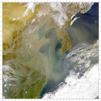
A dust cloud moving from China over Korea and towards Japan on 21 March 2001. SeaWIFS Project/NASA/Godard Space Flight Center/Wikimedia Commons.

During dust and sandstorms sediment particles are swept up by winds, often reaching hundreds of metres into the atmosphere. Larger particles generally fall back to Earth close to the source, but fine dust particles, in the size range 1-10 μm, can be carried for hundreds of kilometres on the westerly winds, often falling on Korea or Japan two or three days after being picked up by the storm.

These storms only develop when strong winds blow over dry sediments, and a combination of high and low pressure centre's generates a strong updraught. As air is swept from an area of high pressure to one of low pressure it is deflected by the Coriolis forces generated by the Earth's rotation, at a direction tangential to the boundary between the two systems, forming what meteorologists refer to as a trough. The greater the difference between the pressure centres, the higher the wind-speed, and when the wind-speed reaches the 'dust point' it is able to lift dust into the atmosphere. In Asia this dust is then carried eastwards by the prevailing westerly winds. Thus, as the Sun more readily heats exposed soil, leading to higher air pressures, the dust storms are driven by the combination of strong sunlight and dry conditions.

This means that dust is easily generated in areas of semi-desert and desert grassland; as the vegetative cover increases, the roots of Grass and Shrubs hold the soil in place more effectively, and the amount of organic matter, which tends to bind the soil together increases. Eventually the ground vegetation becomes dense enough for leaves and branches to slow the winds, effectively preventing dust formation.

Plants also cool the ground through the transpiration process, further hampering the development of low pressure systems, effectively stopping dust formation. Whereas exposed soil absorbs heat from the Sun, then radiates it back into the atmosphere above, fuelling the generation of low pressure systems. Eventually this will manifest as strong gusts or even a whirlwind as a new trough forms.

A dust storm sweeps across Beijing in March 2021. Todd Lee/Zuma Wire/Rex/Shutterstock. 

A straight line can be drawn across a map of East Asia, separation the lowlands to the south and east from the highlands to the north and west. North of this line lie the Mongolian and Tibetan plateaus, and the drylands between them. To the south lie the forests and agricultural lands of China. This line also marks the effective limit of the Asian Monsoon climate.

During the Northern Hemisphere summer, high evaporation over the Indian and Pacific oceans form rain clouds, which are driven north and east by the prevailing westerly winds, depositing rain across East Asia. An atmospheric system known as the North Pacific High blocks the eastward migration of these rain systems, pushing them northward onto land. However, as these systems move north they meet the prevailing westerlies of Central Asia at the margins of the plateaus, preventing them from carrying their moisture onto the steppes, and creating a permanently arid climate across the interior of Northeast Asia.

However, this system is not immutable, and has changed throughout the Holocene. Around 8000 years ago, during the Holocene Climatic Maximum, global temperatures were significantly higher than today, leading to a much stronger Monsoon, which pushed further inland, causing the drylands to shrink. As the climate cooled after this event, the Monsoon limit retreated to something like its current mark, and the drylands moved eastwards into formerly fertile areas. However, the Monsoon line has continued to shift to a lesser extent throughout Human history, with the rise of the nomad empires of East Asia occurring during the Medieval Warm Period, when the drylands retreated and the plains of Mongolia became more fertile.

A small amount of moisture does make its way northward to the Asian steppes from the East Asian Monsoon, although most is pushed back by the prevailing westerly winds. Similarly, a small amount of moisture from the Sount Asian Monsoon, makes it over the Himalayas to the Tibetan Plateau, and the lands to the northeast. However, the largest source of moisture to this region is the remote Atlantic Ocean; the prevalent westerly winds blowing across Europe and Asia can carry moisture as far as Siberia and the drylands to the east, making this the biggest single source of rainwater in Mongolia and western China.

The annual formation of two weather systems over the North Atlantic, the Azores High and the Icelandic Low, creates a strong pressure trough which directs a stream of rain clouds towards northern Europe in the summer and central Europe in the winter, with some of these rain clouds moving onwards through eastern Europe and Siberia into Mongolia. This is not a simple process, with a series of high and low pressure systems along the way serving to keep pushing the moisture eastwards. The Mediterranean on the other hand, appears to make no contribution to the climate of Central and East Asia.

Thus the three largest contributors of moisture to the drylands of Northeast Asia are the Atlantic, Pacific, and Indian oceans, and the climate of these drylands is influenced by climatic events over these oceans, such as the El Niño/La Niña oscillations, the Atlantic Multidecadal Oscillation, and the Pacific Decadal Oscillation. Thus desertification cycles and dust storm events can be driven by climatic oscillations far from the drylands where they occur.

Rainfall records exist since 1940 for the cities of Ulaanbaatar and Dalanzadgad in Mongolia and Yinchuan and Lanzhou in China, to the north and south of the Gobi Desert, respectively. These records show that rainfall in Mongolia follows a roughly twenty year cycle, while in the two northern Chinese cities it follows a roughly five year cycle. This is likely to be connected to the arrival of dust storms in Korea, which has been shown to vary on both five and twenty year cycles. In addition, a general climatic warming in the region from 1970 onwards appears to have fuelled a series of droughts across Northeast Asia, by increasing the rate of evaporative water loss.

Schematic illustration of the recurrent circumglobal teleconnection (CGT) and Atlantic-Eurasian teleconnection (AEA) patterns in summer (June-July-August). The six ellipses denote the six centres of action of the circumglobal teleconnection. The shades areas denote the five centres of action of the Atlantic-Eurasian teleconnection. The solid black and green curves with arrows denote the wave paths of the circumglobal teleconnection and Atlantic-Eurasian teleconnection, respectively. Li & Ruan (2018).

Natural cycles are not the only cause of dust storm events in Northeast Asia. A range of Human activities, including excessive livestock farming, inappropriate crop cultivation in dryland environments, and large-scale mining operations can all reduce vegetative cover, and lower groundwater reserves, leading to droughts and desertification. Nevertheless, desertification does not automatically lead to dust storm events, it simply increases the size of the area in which these conditions can develop. This may mean that global climate change has a greater impact on the formation of dust storms than local desertification events. In the 1980s and 1990s, the drylands of northern China experienced extensive deretification, but this did not lead to a rise in dust storms due to a fall in wind speeds over the same period.

Desertification is the process by which non-desert areas are converted into deserts, a process with is accompanied by a loss of vegetative cover, leading to more exposed soil areas where dust storms can form. Furthermore, this process promotes the development of low pressure systems, and the accompanying winds, by leaving the ground exposed to direct sunlight.

The Ordos Plateau of Inner Mongolia, the area which includes the Kubuqi Desert, has had a 2000 year climatic record reconstructed from lake core samples. This shows that high levels of dust formation were associated with periods when the levels of Human settlement in the area were the highest. This in turn coincided with a period when the Asian Monsoon was strong, and higher levels of moisture were reaching the Plateau, leading to more vegetation growth, indicating that Human actions were overwhelming the natural processes in the region a thousand years ago.

Pastorialism has occurred for a long time on the steppes of Asia. Livestock grazing crops the the grass close to the ground, lowering the wind speed needed for dust uplift, while at the same time increasing ground temperatures by leaving more soil exposed to the direct sun.  Thus livestock farming has an inherent tendency to drive desertification and dust storm generation, particularly if to many Animals are raised densely in a small area of the dryland.

In the 1980s and 1990s attempts to convert parts of the drylands of northern China, including Inner Mongolia, into arable land led to widespread desertification. Then in the early 2000s a severe drought led to a series of massive dust storm events, leading to a change in policy. Since this time efforts have been made to reverse this desertification and restore natural vegetation to the area. These have been successful in some places, but the extent to which the dry grasslands of Inner Mongolia have recovered remains uncertain.

Livestock farming has also increased rapidly in Mongolia since 1991, when the country transitioned from a socialist to a market economy. This has been partly driven by the herding of Goats for cashmere, a valuable commodity. Overgrazing of the grasslands has accompanied this expansion in herding, particularly in areas around cities, and there are concerns that this may lead to a major desertification event. At the same time, a change in rainfall patterns has led to a recovery of the grasslands of northern and eastern Mongolia, which had previously been affected by desertification, which has caused many to question the link between overgrazing and desertification within the country.

Mongolia suffered severe dzud events in 2000-2002 and 2009-2010, during each of which periods about 30% of the country's livestock was lost. These years were also severe dust storm years. The term dzud can refer to any severe winter, but livestock die-offs generally happen when a summer drought is followed by a severe winter. Ecologically speaking, this is an effective control mechanism, reducing the number of grazing Animals, and therefore enabling the grasslands to recover from overgrazing. However, this caused severe social problems for the people involved, destroying the livelihood of nomads, causing migrations of impoverished people to the cities, and widening the gap between the rich and the poor.

Over the past few decades, a variety of efforts have been made to prevent desertification events on the grasslands of Northeast Asia, some of which have been quite successful. However, the difficulty in proving a direct connection between Human activities and climatic events, in this case desertification, can place pressure on policy makers to pursue other priorities. Nonetheless, the reduction of desertification and dust storm genesis hinges in maintaining vegetative cover in the drylands, although this will often be complicated by far away events beyond the control of policy makers.

A herder with her goats in southern Mongolia.. Adam Oswell in McLaughlin (2019).

Dust storms in Northeast Asia are driven by the geography, climate, and vegetation cover of the grasslands of the Asian Steppes, which in turn are driven by global climatic events. Thus any future global climate change will have an impact on the climate of these grasslands, and the occurrence of dust storms across Northeast Asia.

Rising spring temperatures appear likely to cause earlier onsets of the spring dust storm season, while alterations to the Siberian High pressure system may increase the number of dust storms in the autumn, and effect the spring weather in unpredictable ways. Intensification of the El Niño/La Niña oscillation could potentially destabilise the climate of Northeast Asia, by causing larger fluctuations in annual rainfall in the drylands. A decrease in the Arctic ice cover is likely to increase the range of temperature fluctuations in the region, with adverse affects for both livestock and vegetation.

Desertification, dust storms, and dzuds are all the result of a combination of events hitting the grasslands of Northeast Asia. The most obvious factors are droughts and vegetation cover, but these in turn are driven by a variety of other factors, including distant climate systems and grazing management by Humans. Ultimately, all other factors are probably less important than global climate patterns, which fluctuate on a scale of decades, and currently considered to be under threat of severe modification by Human actions.

See also...

Follow Sciency Thoughts on Facebook.

Follow Sciency Thoughts on Twitter.


Tuesday, 27 December 2022

Calcitic shells in an Earliest Cambrian Mollusc.

Calcium carbonite can be precipitated from water into two polymorphs with different crystal structures, calcite and aragonite. The type of crystal precipitated by non-biological processes, such as abiotic marine cement and ooid formation, is determined by seawater chemistry, with aragonite being precipitated when magnesium ions are at least twice as numerous in the seawater as calcium ions in the water, and calcite being precipitated when magnesium ions are less numerous. 

Some simple reef-producing organisms also produce calcium carbonate in either form, in response to seawater chemistry, but most organisms produce either calcite or aragonite, with the process occurring within their tissues, where they effectively control the seawater chemistry. Most marine organisms produce low-magnesium calcite rather than aragonite, which is probably advantageous, as calcite is far more stable to changes in seawater chemistry. However, the earliest small shelly fossils from the Lowest Cambrian Terreneuvian Epoch (between 538.8 and 521 million years ago) appear to all have been arogonitic in nature, with various groups of Animals having subsequently evolved calcitic skeletons, which has led to the assumption that the Earliest Cambrian had an 'Aragonitic Ocean', with a high magnessium content.

In a paper published in the journal Geology on 2 November 2022, Luoyang Li of the Frontiers Science Center for Deep Ocean Multispheres and Earth System at the Ocean University of China, and the Laboratory for Marine Mineral Resources at the National Laboratory for Marine Science and Technology, Timothy Topper of the Shaanxi Key Laboratory of Early Life and Environments at Northwest University, and the Department of Palaeobiology at the Swedish Museum of Natural History, Marissa Betts, also of the Shaanxi Key Laboratory of Early Life and Environments at Northwest University, and of the Palaeoscience Research Centre at the University of New England, Dorj Dorjnamjaa of the Institute of Paleontology of the Mongolian Academy of Sciences, Gundsambuu Altanshagai and Gundsambuu Altanshagai, also of the Institute of Paleontology of the Mongolian Academy of Sciences, and of the School of Arts and Sciences at the National University of Mongolia, Guoxiang Li of the State Key Laboratory of Palaeobiology and Stratigraphy at the Nanjing Institute of Geology and Palaeontology, and Christian Skovsted, again of the Shaanxi Key Laboratory of Early Life and Environments at Northwest University, and the Department of Palaeobiology at the Swedish Museum of Natural History, describe an apparent low-magnesium calcite-producing Mollusc from the Terreneuvian Bayangol Formation at Bayan Gol in the Zavkhan Basin of southwestern Mongolia.

The Bayangol Formation has produced hundreds of shells of the Helcionelloid Mollusc, Postacanthella voronini, considered to be a stem-group Conchiferan (i.e. an early member of the group that includes Bivalves, Gastropods, Cephalopods, Monoplacophorans, and Scaphopods). These come from the Purella shelly biozone, which has been dated to approximately 555 million years ago.

Changes in Metazoan skeletal mineralogy in oscillating seawater conditions across the Ediacaran/Cambrian transition. (A) Animal skeletal mineralogy (top); Mollusc (middle); and constraints on seawater chemistry (bottom). Boxes denote fluid inclusions in marine evaporite deposits; dashed line denotes the possible turning point of seawater chemistry from the Terreneuvian aragonite sea to subsequent calcite sea. E, Ediacaran; Fort, Fortunian. (B) Specimen NRM Mo196849 showing preservation of phosphatic infillings (white arrow), prismatic organic matrix (yellow arrow), and delicate polygonal textures (black arrow) on the surface of the internal molds. (C) Specimen NRM Mo196850 showing overall morphology of Postacanthella voronini. Li et al. (2022).

Seen under the scanning electron microscope, the structure of the shell organic matrix and prismatic crystalline microstructure of the shells of Postacanthella voronini can be seen, replicated in apatite, a phosphatic mineral which has replaced the mineral structure early in the preservation process. Apatite has the ability to adopt the structure of other minerals as it replaces them (most minerals form crystals of a specific shape, tending to destroy fine structures during replacement. This mimicking process gives apatite its name, which derives from the Greek ἀπατάω (apatáō), meaning 'to deceive', but also makes it extremely useful to palaeontologists wishing to study the microstructure of ancient tissues.

The crystalline microstructure of the shell of Postacanthella voronini is comprised of tightly-packed, parallel, columnar prismatic crystals with polygonal cross sections. Clusters of these columnar crystals are bound together by a sinuous intraprismatic organic membrane, similar to that seen in shells of modern Pearl Oysters, Pinctada spp., although the individual crystals of the Postacanthella shells are somewhat smaller than seen in Pinctada. The surface of the Postacanthella shells shows polygonal structures, derived from the cross-sectional shape of the columnar crystals, these being about 10 μm in diameter and slightly convex and cell-like, with the raised margins apparently corresponding to the intraprismatic organic membrane.

Prismatic organic matrix of Terreneuvian Postacanthella and modern Pinctada shells. (A), (B) Digital and scanning electron microscope observations of partly decalcified Pinctada prisms showing three-dimensional organic matrix framework (specimen NRM Mo196851). (C), (D) Scanning electron microscope details of interprismatic and intraprismatic organic matrix of a Cambrian Terreneuvian Postacanthella shell (specimen NRM Mo196852). PM, prismatic organic membrane. Li et al. (2022).

The preservation of prismatic microstructures of Cambrian shells in apatite is not a new concept; it is this preservation which tells us about the aragonite structure of many Cambrian shells (aragonite itself is unstable, and seldom survives for hundreds of millions of years). However, this is the first time that the organic matrix of a Cambrian shell has been observed in this way. This general absence is not surprising, as the organic matrix typically makes up less than 5% of the shell's structure, and is made of proteinaceous material which generally breaks down quickly after the death of the Animal. Fossil shell organic matrices have been recovered before, but only from Mesozoic or later specimens.

However, it is the nature of the crystals moulds preserved within the apatite microstructure that is remarkable. Aragonite and calcite crystals form in quite different ways, with aragonite crystals fanning outwards from a central radiant point, to form a flower-like structure, so that the shell structure comes to resemble a series of interlocking flowers. Calcite crystals, on the other hand, grow in a linear fashion, and bundles of parallel crystals are quite typical. 

Calcitic simple prismatic microstructure of Postacanthella. (A) Scanning electron microscope images of specimen NRM Mo196853 showing overall morphology of Postacanthella voronini. (B), (E), (F) Small prisms with parallel second-order crystal subunits. (C), (H) Inter- and intraprismatic organic membranes of large mature prisms. (D) Prismatic organic matrix. (G) Two adjacent small prisms and mutually parallel second-order structural subunits. (I)–(L) Small individual prisms with numerous lath-like second-order subunits encased within organic sheaths. (M)–(P) Well-defined polygonal texture formed by interprismatic organic membranes. PM, prismatic organic membrane. Li et al. (2022).

The widespread presence of aragonitic shells in Early Cambrian organisms has led to the conclusion that the Earliest Cambrian ocean had a high-magnessium, 'arogonitic' nature. Under such circumstances, it would be easier for organisms to evolve the ability to develop aragonite shells, which would then persist within evolutionary lineages. 

Most organisms will produce either calcite or aragonite shells regardless of the water chemistry (as the crystal formation occurs within their tissues, where chemistry is under their control), with switches between the two systems being rare. This means that organisms will, in theory, develop the ability to form calcium carbonate crystals of a type that matches the water chemistry.

This is not, however, an absolute rule. The Micrabaciids, a group of Sclerectinian Corals today restricted to the deep oceans, produce aragonitic skeletons, but first appeared in the Cretaceous, when the seas had a high calcium, low magnesium chemistry (i.e. a 'calcite' ocean). Some calcite-producing Bivalves will produce aragonite shells if places in water with a high enough magnesium content. Furthermore, there has been a general tendency throughout the Phanerozoic for organisms in warm seas to produce aragonitic shells, while those in cold seas make shells from calcite.

Molluscs are unique in their ability to secrete calcium carbonate crystals from an organic membrane within the shell. In the aragonitic Terreneuvian ocean, Mollusc shells were built from aragonite in a variety of ways, including prismatic aragonite, foliated aragonite, and various regular-irregular fibrous microstructures. Subsequently, in the calcitic seas of the Stage 3 Cambrian and above, Molluscs developed the ability to secrete calcite from their shell membranes, forming foliated calcite and calcitic semi-nacre microstructures. Postacanthella voronini appears to be an exception to this rule, having already developed the ability to secrete a low-magnesium calcite shell in the high-magnessium shell in the high magnesium aragonitic Terreneuvian ocean.

This in turn suggests that the selection of a calcium carbonate polymorph when developing the ability to secrete a shell is influenced by, but not absolutely controlled by seawater chemistry.

See also...

Online courses in Palaeontology. 

Follow Sciency Thoughts on Facebook.

Follow Sciency Thoughts on Twitter.


Friday, 25 October 2019

Musk Deer from the Miocene of Mongolia.

Musk Deer, Moschidae, are small Artiodactyls closely related to True Deer, Cervidae, but differing from them in the absence of antlers; instead the males have enlarged, tusk-like canine teeth which are used in conflict with other males. Musk Deer also lack the facial glands of True Deer, instead the males have a musk gland in their genital area. Unfortunately this musk gland is highly prised in the perfume industry and Chinese medicine, with the effect that six of the seven extant species of Musk Deer are now classified as Endangered under the terms of the International Union for the Conservation of Nature's Red List of Threatened Species, with the remaing species being classed as Vulnerable. All extant species of Musk Deer are placed in a single genus, Moschus, found within wooded areas of Asia. The group is represented by twenty seven fossil species, split into fourteen genera, dating from the Miocene onwards, with the oldest known specimens coming from Serbian strata dated to about 17 million years ago. However, almost all known fossil specimens assigned to the group are from Europe, with fossil Musk Deer only reported from two Miocenesites in China, Silong in  Jiangsu Province, and Damiao in Hebei, with the Sihong specimens being lost.

In a paper published in the journal Palaeontologica Electronica in August 2019, Bastien Mennecart of the Naturhistorisches Museum Wien and the Naturhistorisches Museum Basel, Manuela Aiglstorfer of the Staatliches Museum für Naturkunde Stuttgart, and Ursula Göhlich and Gudrun Daxner-Höck, also of the Naturhistorisches Museum Wien, describe a serious of isolated Musk Deer teeth from Loh Formation at the Miocene Ulan Tolgoi locality in the Valley of Lakes Region of Mongolia.

The locality Ulan Tolgoi is situated in the northeast of the Taatsiin Tsagaan Nuur Basin, which is part of the Valley of Lakes in Central Mongolia. From bottom to top, the basin is filled with Mesozoic and Cenozoic continental sediments. From 1995 to 2012, the Mongolian Academy of Sciences and the Natural History Museum of Vienna carried out an extensive program of field work in Oligocene and Miocene deposits of the Valley of Lakes region in Mongolia. This project’s output included several scientific publications, the identification of about 19 000 fossils, the description of 175 fossil Mammal species (including 32 newly erected species), and the first precise integrated stratigraphy of the Mongolian Oligocene and Miocene combining biostratigraphy and radiometric dating. 

Geographic position (1) of Mongolia (black) in Asia (light grey) and (2) of the Ulan Tolgoi locality (black square). (3) Photo of the Ulan Tolgoi locality taken by Gudrun Daxner-Höck during fieldwork in August 2015. Mennecart et al. (2019).

A 50 m thick sediment sequence of the Loh Formation is exposed along a southwest to northeast striking ridge at Ulan Tolgoi. From bottom to top, the beds are: (1) reddish-brown sandy siltstone, followed by (2) whitish-grey sandstone and siltstone with gravel lenses (scattered bones included). The sandy whitish part is locally covered by (3) a reddish-brown silty claystone, followed by (4) a rose-grey siltstone layer Towards the top of the sequence (5) brown silt, and (6) quaternary gravels follow.

The age of the Ulan Tolgoi fauna can only be inferred from biostratigraphic data, because no Miocene basalt is exposed in this region, and no magnetostratigraphic data are available so far. Comparisons of the Ulan Tolgoi fauna to Mammals from early and middle Miocene faunas from Inner Mongolia in China show that most genera listed from Ulan Tolgoi have their lowermost occurrences in the early Miocene and beginning of the middle Miocene.

The Ulan Tolgoi fossil collection is composed of small and large Mammals. Small Mammals were selected from three screen washed samples, and scattered large Mammal remains were collected from surface in the vicinity of the sample places. Though the fauna comprises 21 genera, though species identification is almost impossible, because the taxa are represented by only one or a few specimens.

Very few Ruminant species and specimens were described from the Ulan Tolgoi Miocene deposits during the course of the project, with those that were assigned to the genera Eotragus (a Bovid) and Lagomeryx (a member of the Lagomerycidae, or Rabbit Deer, an extinct group that may have been ancestral to both the True Deer and Musk Deer). 

The first specimen discussed by Mennecart et al. is a right lower second premolar with preserved roots, measuring 5.8 x 2.9 mm. The enamel of this specimen is slightly pleated on the lingual side (inner side, literallty the side towards the tongue). The anterior conid (front cust of a lower premolar) is located anteromedian (in front of the midline), forming a pointed anterior part of the tooth. The straight anterolabial cristid (front outside ridge) starts from the apex of the mesolabial conid (outside middle cusp) and joins the anterior conid (back cusp) on its posterolabial (outside back) side. The anterior conid is low and does not form any labial relief. The large mesolabial conid is the highest cuspid. It is located central and median. It possesses a broad posterior part. Since the posteriolingual conid is labiolingually oriented, it forms a narrow and deep posterior valley. The posterolingual conid is long, reaching to the lingual side of the tooth, forming a small protrusion. On its labial face (outside, towards the lips), we can observe a vertical depression. The posterolabial cristid (boack outside ridge), reaching from the mesolabial conid apex to the labial part of the posterolingual conid, is curved. The posterolabial conid (back outside cusp) is quite distinct. It forms the posterolabial corner of the tooth. As there is no posterior stylid (ridge running vertically down the middle of the tooth), the back valley is widely open. The posterolingual conid (back inside cusp) is higher than the anterior conid. There is no cingulid (ridge that runs around the base of the crown of a lower tooth).

Right lower second premolar from the Ulan Tolgoi Miocene deposits in labial (7), occlusal (8), and lingual (9) views. Mennecart et al. (2019).

The second specimen described is a fourth lower premolar with preserved roots measuring 8.6 x 4.9 mm,  which was formerly assigned to Lagomeryx, but which they consider to be an indeterminated Musk Deer. This specimen is a little worn, high crowned, and the enamel is slightly wrinkled. There is a short anterolabial cingulid (ridge running around the front and exterior surfaces) and a vestigial anterolingual cingulid (ridge running around the back and interior surfaces). The mesolabial conid (medium outside cusp) is located median (in the middle). It is smaller than the mesolingual conid (middle inside cusp). The latter is slightly shifted to anterior (front) and is laterally compressed (flattened sideways). It is the highest conid. The very deep anterior valley is closed by the connection of the anterolingual cristid (front inside ridge) and an enlarged anterior conid (front cusp). The anterior conid shows an additional minute anterior bifurcation. The anterior stylid (central ridge) forms the anterolingual (front inside) edge of the tooth. The oblique transverse cristid (diagonal ridge crossing the tooth) fuses with the posterior end of the posterolingual cristid (back inside ridge) building the posterior wall of the anterior valley. Transverse cristid and posterolingual conid (inside back cusp) are oriented parallel, as are posterior and back valley. The valleys are both deep and oriented obliquely. The posterior valley is open lingually. The posterior cristid turns posteriorly at the base and almost reaches the posterolingual edge of the tooth closing the back valley basally. The posterolabial cristid is very short, and the posterolabial conid is well-marked. There is a distinct labial depression anterior to it. The posterior stylid (back central ridge) is very weak. The posterior interdental contact surface implies that the fourth premolar was considerably intruded by the first premolar.

Right fourth premolar from the Ulan Tolgoi Miocene deposits in labial (4), occlusal (5), and lingual (6) views. Mennecart et al. (2019).

The next specimen is a medium-sized molar has a fully developed The medium-sized molar has a fully developed selenodonty (form suited to herbivory, with a low crown and cresent-shaped cusps). The enamel is slightly wrinkled. The lingual side of the tooth is flattened. The conids (cusps) are not fully aligned, comprising an intermediate situation between the condition of Bovids and Cervids/Palaeomerycids, as observed in some Moschid taxa. All cristids (ridges) are more or less straight. The preprotocristid and prehypocristid (front ridges) are parallel and oriented obliquely to the main axis of the tooth. The same applies to internal postprotocristid and posthypocristid (back ridges). The prehypocristid is lower and terminates in the posterior wall of the internal postprotocristid. It does not meet the connection between internal postprotocristid, preentocristid, and postmetacristid. A well-developed, long and  slender, external postprotocristid starting from the apex of the protoconid forms a deep 'Palaeomeryx fold'. The metastylid is weak and the entostylid is absent. Postentocristid and posthypocristid are fused and close the posterior wall. The ectostylid is very well-developed. The anterior cingulid is weakly developed. Due to the strong 'Palaeomeryx fold' and the still marked anterior cingulid, Mennecart et al. consider the tooth to be a first.

First molar from the Ulan Tolgoi Miocene deposits in labial (1), occlusal (2), and lingual (3) views. Mennecart et al. (2019).

The final specimen is a right third molar measuring 11.1 x 5.4 mm, formerly identified as Lagomeryx sp., but considered to be assignable to the genus Micromeryx and probably the species Micromeryx primaevus, a species previously described from the Miocene of Europe and China. The specimen is selenodont. The enamel is slightly wrinkled. The lingual wall is more bulgy than in the first molar, and the lingual cuspids are less aligned. The and the lingual cuspids are less aligned. The metastylid (ridge in front of the middle cusp) is very strong. The prehypocristid nearly meets the connection between internal postprotocristid, preentocristid, and postmetacristid. A well-developed, long, and bulky external postprotocristid, starting from the apex of the protoconid, forms a deep 'Palaeomeryx fold' with the internal one. There is a quite distinct entostylid (inside ridge) sitting lingual on the developed entoconulid (on the toungeward side of the inside cusp). The preentoconulidcristid connects the posthypocristid and the entostylid. The back fossa (depression) of the molar is oblique. The selenodont and quite large hypoconulid forms the posterolabial corner of the molar. The ectostylid and the posterior ectostylid are very well developed. The anterior metastylid is weakly developed.is very strong. The prehypocristid nearly meets the connection between internal postprotocristid, preentocristid, and postmetacristid. A well-developed, long, and bulky external postprotocristid, starting from the apex of the protoconid, forms a deep 'Palaeomeryx fold' with the internal one. There is a quite distinct entostylid sitting lingual on the developed entoconulid. The preentoconulidcristid connects the posthypocristid and the entostylid. The back fossa of the mollar is oblique. The selenodont and quite large hypoconulid forms the posterolabial corner of the molar. The ectostylid and the posterior ectostylid are very well developed. The anterior cingulid is weakly developed.

Micromeryx. cf. primaevus: left third molar fromthe Ulan Tolgoi Miocene deposits in labial (10), occlusal (11), and lingual (12) views. Scale bar is 10 mm. (13) dental nomenclature of the lower molar: Ci, anterior cingulid; Ec, ectostylid; En, entoconid; End, entoconulid; Hy, hypoconid; Hyd, hypoconulid; Me, metaconid; Med, metastylid; PF, “Palaeomeryx fold”; Pr, protoconid. (14) dental nomenclature of the lower premolar: AC, anterior conid; AS, anterior stylid; MaC, mesolabial conid; Mic, mesolingual conid; PaC, posterolabial conid; PiC, posterolingual conid; PS, posterior stylid; TC, transverse cristid. Mennecart et al. (2019).

See also...

https://sciencythoughts.blogspot.com/2019/07/charging-bison-injures-nine-year-old.htmlhttps://sciencythoughts.blogspot.com/2019/06/muntiacus-gigas-new-specimen-of-giant.html
https://sciencythoughts.blogspot.com/2018/03/giraffe-tracks-from-late-pleistocene-of.htmlhttps://sciencythoughts.blogspot.com/2016/08/lightning-kills-323-reindeer-in.html
https://sciencythoughts.blogspot.com/2016/01/ammotragus-lervia-diet-of-barbary-sheep.htmlhttps://sciencythoughts.blogspot.com/2015/12/capreolus-constantini-roe-deer-from.html
Follow Sciency Thoughts on Facebook.