Showing posts with label Palynology. Show all posts

Saturday, 24 August 2024

Using microfossils and pollen to determine the origin of a set of stocks in the collection of the Rijksmuseum, Amsterdam.

In 2019 a man donated a set of stocks to the Rijksmuseum in Amsterdam, which he claimed his  grandfather had acquired in the  1970s from a farm in Zeeland Province.  The museum put the stocks on display in 2021, as part of an exhibition about the Dutch colony in Brazil between 1630 and 1654. In 2023, the stocks were loaned to the United Nations in New York, where they formed part of an exhibition about slavery in Dutch colonies. However, during the New York exhibition, questions were raised as to whether the stocks had ever actually been to South America. A radiocarbon analysis suggested that the tree from which the stocks had been made was probably felled in about 1800, with the stocks probably being made in the first quarter of the nineteenth century. Furthermore, DNA testing established that the wood came from a lineage of Oak trees, which today is found growing in Europe between northern Spain in in the south and southern Scandinavia in the north. 

In a paper published in the journal Review of Palaeobotany and Palynology on 10 August 2024, Hans Piena of the Vrije Universiteit Amsterdam, the Dutch Open Air Museum, and the Royal Netherlands Historical Society, Bas van Geel of the University of Amsterdam, Tom Hakbijl of the Naturalis Biodiversity Center, Arie Kalis of Goethe University, Pim van der Knaap and Jacqueline van Leeuwen, also of the University of Amsterdam, and Kees Nooren of Utrecht University, describe the results of a study which looked at palynological evidence (preserved pollen and spores) to develop a forensic picture of the environment in which the stocks had been used.

Oak stocks in the collection of the Rijksmuseum in Amsterdam (Inv.nr. NG.2019–502). Measurements: 265 × 37.5 × 23 cm. Piena et al. (2024).

Sediment was extracted from holes and cracks in the stocks, and analysed for palynomorphs (pollen, algae and spores), and the surface of the stocks were analysed for surface wear and other traces of use.

The stocks comprise two oak beams resting on a pair of cross-braces. Each beam has nine semicircular openings, which correspond to similar openings on the other beam, with the pair making a hole. on the other beam. At one end of the beams is an iron hinge, at the other an obliquely worn padlock eye. The insides of the holes have been smoothed to a shiny surface, suggesting that the stocks were used frequently. The upper surface of the beams are also smooth, having apparently been rubbed frequently with sand; cracks and small holes on this surface were filled with sediment. There are also a large number of chopping and cutting marks on the upper surface, in places forming a chequerboard pattern. The underside shows no signs of similar wear or sanding, and is largely free of sediment. 

The two cross-braces yielded traces of attacks by Fungi and Woodworm, which are not seen on the beams, and are interpreted by Piena et al. as feet upon which the stocks sat. They were previously interpreted as side braces in the two slavery exhibitions, which would have led to the stocks being horizontal, holding prisoners seated on the floor. Under Piena et al.'s interpretation, the holes would have been vertical, forcing anyone  trapped in the stocks to stand.

The number '22' has been written on the upper surface of the stocks in blue chalk. The fact that this has not been rubbed of strongly suggests that it was written after the stocks ceased being used, possibly as part of an inventory process or auction sale. Before the twentieth century, chalk could be produced in few colours other than white, but blue is one of those colours, making it possible the number was written in the nineteenth century. 

The contents of a sediment-filled hole on the upper surface of the stocks were analysed for siliceous microfossils. This produced about 500 000 Diatoms per gram of sediment, with fifty different species identified. These were largely indicative of a mesotrophic freshwater environment, such as a slow-flowing stream or ditch.  This included the epiphytic Diatom Cocconeis placentula, which grows on the surface of aquatic Plants or Macroalgae. No marine or brackish water species were found. Phytoliths (opaline silica crystals which build up in the leaves of Plants as dissolved monosillicic acid taken up with groundwater and precipitated out as water is lost from the leaves via transpiration) associated with Grasses were found, but none associated with Palms. Also present in great numbers were the stomatocysts of Chrysophytes (Golden-brown Algae), which are also typical of freshwater environments, with about 460 000 stomatocysts per gram of sediment. Also present were samples of the freshwater Alga Spirogyra and pollen of the freshwater Plant Myriophyllum alterniflorum. All of these species are indicative of freshwater ecosystems, but otherwise fairly cosmopolitan, and can be found in tropical and temperate environments.

Samples of pollen and spores were extracted from eight different cracks and holes on the surface of the stocks, with five samples being extracted from one large hole. A total of 7106 individual specimens were found, including 142 taxa of spores and pollen, from 18 trees, 21 shrubs, 91 herbs, 5 Ferns, and 7 types of Fungi, Algae, and Moss. This high proportion of herb pollen is likely to be indicative of an open agricultural environment, probably with low nutrient levels. This contained only a small proportion of Chenopodiaceaetype and Plantago maritima-type pollen, making a salt marsh environment unlikely. Many of the pollen types are cosmopolitan in distribution, but others, including Armeria, Cistaceae, Erica arborea, Lavandula, Nerium oleander, Olea, Pinus pinaster, Quercus ilex, Urtica pilulifera, Eryngium tenue, Corrigiola telephiifolia, and Vitis vinifera, are typical of the Mediterranean region, while others, including Erica australis, Erica umbellata, Cistus albidus, Cistus populifolius, Cistus ladanifer, and Halimium halimifolium, are found only on the western Iberian Peninsula and in western North Africa. Notably, the pollen of Cedrus and Chamaerops, which are more-or-less ubiquitous in recent North African sediments, were absent. 

Many pollen samples from cereal species showed signs of heat-deformation, something which has previously been observed in samples from medieval cesspits, and which is thought to be associated with bread or porridge-making.

The stocks also show signs of Insect damage in places, and yielded some Insect samples. The Insect damage comes in two forms. The first of these is wide flat tunnelling in the cambium layer, which would have underlain the bark, and which is caused by the larvae of Buprestid or Cerambycid Beetles. The second form of damage is a series of small boreholes likely to have been caused by Anobium punctatum, a small boring Beetle commonly associated with wooden beams and objects in Europe, which favours humid indoor environments. The Insect remains found belong to Ptinus fur or Ptinus clavipes, Adistemia watsoni, Latridius minutus, and two unidentified members of the Corticariinae. Adistemia watsoni is a species native to South America, but which had spread to Europe by the nineteenth century. The Spider Beetles, Ptinus fur and Ptinus clavipes, are typically found in indoor settings, feeding on Human food or other Pland and Animal remains. A small Mite belonging to the family Macrochelidae was also found. This assemblage has been found in other archaeological settings, and is considered typical of an indoor environment with mouldy food, litter and/or hay, and possibly excrement. 

The underside of one of the cross-braces, which is worn and shows traces of Fungal and Woodworm attack. Piena et al. (2024).

Artefacts will typically begin to assemble traces and small microparticles of biological origin from the moment when they are made, enabling researchers to build up a life history of  objects of interest. Examination of the assemblage associated with the Rijksmuseum stocks showed no evidence of these ever having visited South America, despite earlier interpretations.

A prior DNA analysis of the wood suggests that the stocks were made from a tree which probably grew somewhere between northern Spain and southern Scandinavia, and it seems unlikely that it was transported for any great distance before being worked. This is because only wood with a high market value is typically shipped for any great distance, which effectively means wood with a straight grain and few knots. The wood from which the stocks are made has an irregular grain pattern and is somewhat knotty, which would generally only be used if the desired task required wood to be sourced locally. The stocks also show signs of having been worked using techniques typical for green wood usage, which again makes it highly unlikely that the wood was transported any distance before being used.

The style of the stocks, with holes on top forcing the prisoner(s) to stand is unusual, but is known to have been used widely on the Iberian Peninsula during the early nineteenth century, leading Piena et al. to conclude that the stocks are likely to be of Iberian origin.

The samples collected can be expected to have started to accumulate as soon as the stocks were  made, and to have continued to accumulate throughout their existence. Samples were taken from locations all over the stocks, and in one in one location, a hole, a succession of samples were taken from different depths. Despite this, other than samples from the lower side being dusty and samples from the upper side being sandy, there was remarkably little difference in the samples, suggesting that the stocks spent much of their lives in a single environment. 

The pollen samples collected from the stocks suggest that this environment was in western Iberia, while the DNA collected from the wood suggests that it grew no  further south than northern Iberia, which is at least a neighbouring region. 

The Insects collected from the stocks suggest a humid, indoor environment, while the presence of cereal pollen, and good preservation of the Diatoms and pollen suggest that the sediment in which they were preserved did was not exposed to moisture for long periods.

Based upon this evidence, Piena et al. consider two separate scenarios, which could account for the accumulation of microfossils seen on the stocks. 

It is possible that the entire assemblage is post-use, representing a time when the stocks had been abandoned in a slow-moving stream or ditch, in an open agricultural environment with poor soils and intensive Rye cultivation, an environment typical of the Iberian Peninsula in the nineteenth century. This scenario is supported by the good preservation of pollen and Diatoms, the type of sediment found, and the low number of Fungal spores, but contradicted by the presence of sediment only on the upper side of the stocks, not on the underside or in the cavities between the beams and cross-braces. 

Alternatively, the large amount of pollen from wild Grasses and Cereals, particularly Rye, makes it possible that the stocks were used in an indoor environment where Grass and Rye straw were used as litter. This is supported by the types of spores present, which are all from species associated with decaying Plant matter or Animal dung (including Human). This is consistent with the idea that the stocks were used in a humid, indoor environment. The presence of Fungal and Woodworm damage to the underside of the stocks would be consistent with them sitting on a moist floor covered with a litter of straw and hay, possibly in a stable or dungeon (with the latter being more likely, given the presumed purpose of the stocks). Thus the deformed Cereal pollen could have come from bread or porridge fed to prisoners, or their faeces if they were forced to produce this while trapped in the stocks, and the sand in the cracks on the upper surface would be consistent with frequent scrubbing of this surface. 

Historically, most stocks around the world were positioned on their sides, with prisoners thus able to lie down. The Rijksmuseum stocks, however, are of a far rarer design, which held the prisoner in an upright position, forcing them to stand upright. Such stocks were often ued in conjunction with a neck brace on a wall, so that prisoners could be held upright and restrained. This was once common in Spanish prisons, providing a likely origin for the stocks. Notably, such stocks were particularly common during the Peninsula War of 1807-1814 and the Spanish War of Independence of 1814-1823, both wars which were noted for numerous attocities. In other settings, however, stocks of this type were combined with a latrine bench with holes, with prisoners being held in a sitting position.

Por liberal?, 1814–1823, by Francisco de Goya y Lucientes, showing a  woman trapped in a horizontal type of stocks. Piena et al. (2024).

When obtained, little was known about the set of stocks present in the collection of the Rijksmuseum. They were identified as having (recently) come from Zeeland, and were considered appropriate for an exhibition about the Dutch colony in Brazil between 1630 and 1658. Subsequent investigations have suggested that they were most likely made in Europe around 1800, and never taken to South America. Subsequent investigations by Piena et al. have narrowed the likely point of origin to the western Iberian Peninsula, and suggest that they were used in a moist indoor environment, most likely a dungeon.

See also...

Friday, 14 April 2023

Examining the impact of the Palaeocene–Eocene Thermal Maximum on sedimentation in the Gulf of Mexico.

Roughly 56 million years ago, global temperatures abruptly rose by 5-9°, leading to profound environmental changes across the planet, an event known as the Palaeocene–Eocene Thermal Maximum. This event was marked (and probably caused by) a sharp rise in atmospheric carbon dioxide, something marked in the rock record by a 3.0‰ negative carbon isotope excursion (three parts per thousand drop in the proportion of carbon¹³ to total carbon), which developed over a period of less than 5000 years. Three main stages to this negative carbon isotope extension have been detected; the onset, during which the proportion of carbon¹³ dropped from the pre-excursion level to the excursion level; the body, during which the proportion of carbon¹³ remained steady at the new, lower level; and the recovery, during which the proportion of carbon¹³ returned to the pre-excursion level.

This interval was also marked by a dramatic increase in the prevalence of the Dinoflagellate cyst Apectodinium spp., and a widespread dissolution of carbonates (a sign that the sea had become slightly acidic due to the higher atmospheric carbon dioxide levels). The negative carbon isotope excursion has been detected in a wide range of sedimentary setting, from continental interiors to ocean basins, although its cause is still debated. It is generally accepted that the rise in atmospheric carbon dioxide, combined with the drop in the proportion of carbon¹³, is indicative of the atmosphere receiving a sudden, and very large, input of carbon¹³-depleted carbon dioxide, with the most popular explanations for this being a volcanic source or a sudden increase in the proportion of carbon dioxide being released from land Plants and soils (this could be response to heating, leading to a feed-back loop in which the released carbon dioxide causes a rise in temperature, leading to further carbon dioxide being released, something which concerns climate scientists studying current rising global temperatures). It has also been suggested that the initial pulse of heating might have been caused by an increase in the proportion of biogenic methane (another potent greenhouse gas).

The Gulf of Mexico forms an enclosed basin within the area bounded by the southern coast of the United States, the east coasts of northern Mexico, and the Yucatan and Florida Peninsula. This basin formed by sea-flood spreading during the Jurassic and Early Cretaceous, with deposits of clasitic and carbonate sediments building up along its northern margin during the Cretaceous and Palaeocene. This sedimentation increased rapidly during the Palaeocene–Eocene Thermal Maximum, leading to a prograding  (movement of shoreline towards the sea) of the fluvio-deltaic Wilcox Group. During this time, most of what is now the southern United States formed a single catchment area, driven by the Laramide Orogeny as the Rocky Mountains began to form. The sedimentary material formed by erosion within this catchment was carried into the Gulf of Mexico, forming the deltas of the Houston, Mississippi, and Rio Grande rivers. These sediments served as a trap for hydrocarbons derived from organic material swept into these deltas, which has led to extensive hydrocarbon exploration of the basin in the twentieth and twenty first centuries. This data has enabled geologists to build up a good picture of sedimentation rates within the Gulf of Mexico throughout the Cainozoic, with a distinct increase on sedimentation rates visible at the Palaeocene–Eocene Thermal Maximum.

The Wilcox Group is a succession of fluvial, deltaic, and shallow marine sediments, which outcrops in parts of Alabama and Texas, where it is targeted by numerous onshore oil wells. The group progresses offshore, where its outer margins contain turbidite deposits, which are drilled by offshore oil rigs. The Wilcox Group can be divided into Lower, Middle, and Upper units, which the base of the Upper Unit marked by the Yoakum Shale, which is thought to mark the onset of the Palaeocene-Eocene boundary. The carbon isotope excursion associated with the Palaeocene–Eocene Thermal Maximum has been detected at several locations within the Wilcox Group, although principally within the onshore fluvial and deltaic deposits and the plains of the Gulf of Mexico. Within the distal part of the submarine fan, the Palaeocene–Eocene Thermal Maximum has been detected biostratigraphically, but not through the detection of the carbon isotope excursion. There is localized evidence of environmental change within the delta, recorded by prograding of sediments over an area of thousands of kilometers, with material from river drainages reaching to the deep ocean floor. 

The ability to connect a prograding deep sea fan to a well understood river catchment system provides a unique opportunity to study enviromental changes across an entire sedimentary system from the source to the outer part of the marine basin.

In a paper published in the journal Geology on 9 February 2023, Lucas Vimpere of the Department of Earth Sciences at the University of Geneva, Jorge Spangenberg of the Institute of Earth Surface Dynamics at the University of Lausanne, Marta Roige of the Departament de Geologia at the Universitat Autònoma de Barcelona, Thierry Adatte of the Institute of Earth Sciences at the University of Lausanne, Eric De Kaenel of DeKaenel Paleo-Research, Andrea Fildani of the Deep Time Institute, Julian Clark and Swapan Sahoo of Equinor, Andrew Bowman of the Louisiana Geological Survey, Pietro Sternai of the Dipartimento di Scienze dell’Ambiente e della Terra at the  Università degli Studi di Milano-Bicocca, and Sébastien Castelltort, also of the Department of Earth Sciences at the University of Geneva, present the results of a study that located the isotopic signal of the Palaeocene–Eocene Thermal Maximum within marine sediments in the northern part of the Gulf of Mexico, use this data to place a chronostratigraphic data-point within the strata, and examine the relationship between sedimentation rates and climate change as recorded within the sediments of the Gulf of Mexico.

Vimpere et al. obtained a 543 m thick section from the Logan-1 ultra-deep-water wildcat well, which was sunk in 2011 on Walker Ridge Block, which includes the outer part of the Wilcox Group, about 400 km to the southeast of New Orleans. This well excavated a core beneath 2364 m of water, to a depth of 8351 m beneath sea level. One hundred and seventy eight samples were taken from this section, at three meter intervals, then subjected to bulk and clay X-ray diffraction, Rock-Eval pyrolysis, granulometric, organic carbon isotope, palynological, and calcareous nannofossil analyses.

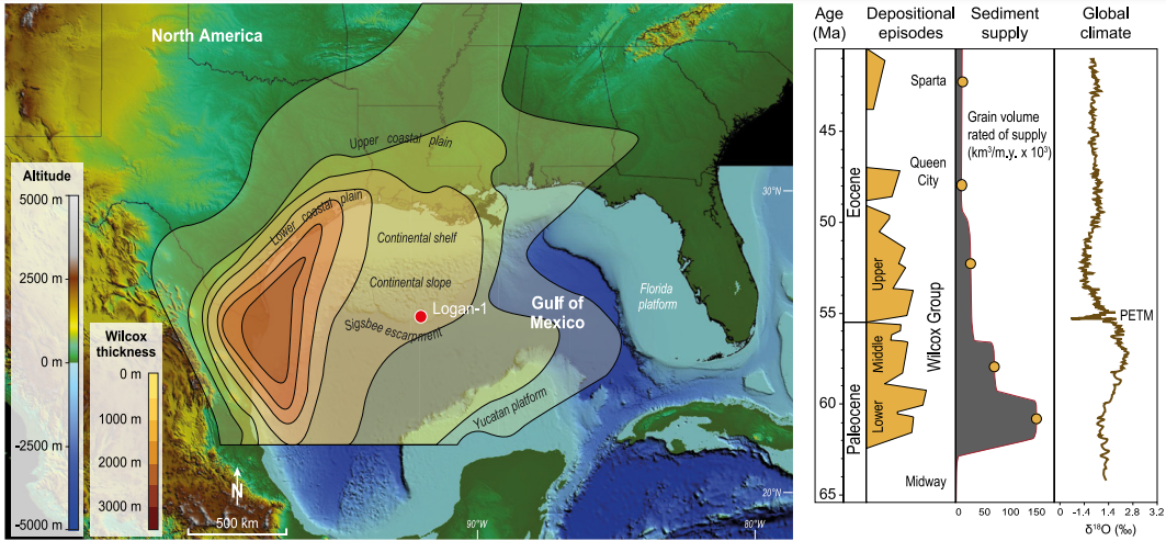
Topobathymetric elevation model of North America showing the Logan-1 well location (drilled in 2011 on Walker Ridge Block 969, ID WR 969 ST0 #1) and present main geographic features. Depositional context during the Paleocene-Eocene transition is represented by Wilcox Group thickness and key tectono-stratigraphic events in the Gulf of Mexico sediment routing system. PETM; Palaeocene–Eocene Thermal Maximum. Vimpere et al. (2023).

Examination of palynomorphs and calcareous nanofossils identified the Palaeocene–Eocene Thermal Maximum interval as being present between  8181 and 8001 m within the Logan-1 core, and the  Palaeocene-Eocene boundary as lying between the NP9 and NP10-0 horizons of the calcareous nannofossil assemblage. The carbon-isotope excursion can also be identified within the core, at 8196–8001 m, with an onset 15 m below the Palaeocene-Eocene boundary, and no hiatus in sediment deposition. This pattern has been observed at a variety of locations, and suggests a link between the onset of the Palaeocene–Eocene Thermal Maximum and late Palaeocene volcanism on the e North Atlantic volcanic province, the Caribbean, and mid-ocean ridge areas. The main body interval of the carbon-isotope excursion is found between  8196 and 8108 m, and the recovery phase between 8108 and 8101 m. This gives a Palaeocene–Eocene Thermal Maximum deposit with a thickness of 195 m, making it the thickest Palaeocene–Eocene Thermal Maximum deposit yet discovered. This contrasts with other well cores sunk in the Gulf of Mexico, in which the Palaeocene–Eocene Thermal Maximum sequence has been truncated. A marked increase in the abundance of Dinoflagellate cyst Apectodinium spp. was observed at 8169 m, while glauconite concentrations increased at 8172 m. Both of these are thought to represent sediments having become condensed, and a shift in the shoreline to landward, caused by deepening sealevels associated with the global temperature rise. 

Carbon isotope, glauconite concentration, chronostratigraphic, and lithostratigraphic data and correlations with Gulf of Mexico standard stratigraphy for the section studied in the Logan-1 well (drilled in 2011 on Walker Ridge Block 969, ID WR 969 ST0 #1). δ13Corg measurements and three-point averages are illustrated by the circles and the curve, respectively. GR, gamma ray; Sh, shale; Slt, silt; Snd, sand; YS, Yoakum Shale; CIE, carbon isotope excursion; PETM, Palaeocene–Eocene Thermal Maximum. Nannofossils: Bomolithus aquilus, Discoaster araneus, Discoaster mahmoudii, Discoaster diastypus, Fasciculithus tympaniformis, Rhomboaster cuspis, Rhomboaster bitrifida, Tribrachiatus bramlettei, Discoaster mahmoudii, Coccolithus bownii, Bomolithus supremus, Tribrachiatus bramlettei, Thomsonipollis, Fasciculithus richardii, Caycedoae megastypus, Discoaster multiradiatus, Fasciculithus lillianiae, Fasciculithus richardii, Discoaster acutus. Vimpere et al. (2023).

These results suggest that, in this part of the Gulf of Mexico, sedimentation rates were significantly increased during the Palaeocene–Eocene Thermal Maximum. If the Palaeocene–Eocene Thermal Maximum is assumed to have lasted 170 000 years, then this part of the Gulf of Mexico apparently had an average sedimentation rate of 1.15 m per 1000 years during this interval. The main body of the event comprises 88 m of sediment, thought to have been laid down in 80 000 years, giving a sedimentation rate of 1.1 m per 1000 years, while the recovery period is represented by 107 m of sediment laid down in 118 000 years, giving a sedimentation rate of 1.18 m per 1000 years, although distinguishing the main body from the recovery period is difficult, leading to a substantial margin of error in these calculations.

The Yoakum Shale is considered to represent a maximum flooding surface, created when the Palaeocene–Eocene Thermal Maximum caused the shoreline to retreat by 150 m. In the submarine deposits of the Gulf Coastal Plain this corresponds with a drop in the amount of terrestrial sedimentary material arriving, and the formation of an number of submarine canyons, most notably the Yoakum Canyon off the coast of Texas. These canyons tended to funnel sediments down into the ocean basin, bypassing much of the continental shelf, which became starved of sediment. The sediments of the shelf show a higher proportion of marine palynomorphs (which settle out of the water column) than terrestrial palynomorphs (which are carried out to sea with sediment) during this interval, and are also enriched in glauconite (which only forms in marine settings) relative to the rest of the sediment column. 

Palaeographic map of the northern Gulf of Mexico showing evolution of the depositional systems throughout the Paleocene–Eocene Thermal Maximum. Vimpere et al. (2023).

It could be presumed that the heating and increase in sealevel associated with the Palaeocene–Eocene Thermal Maximum led to the transgression onto the shores of the Gulf of Mexicoby itself, however Vimpere et al.'s findings suggest that this was at least in part due to subsidance of the coastal margins associated with the formation of the submarine canyons, although there is not sufficient data to make an absolute assessment of the influence of the two phenomena.

During the Early Eocene, uplift associated with the second pulse of the Laramide Orgeny forced the waterways carrying sediments into the Gulf of Mexico to shift towards the southwest. This is recorded in the Upper Wilcox deposits, where several major fluvio-deltaic systems are rejuvinated. This in turn led to stabilization of the system, with less wandering by channels, enabling sediments to build up and prograde out over the shelf margin. This prograding of the delta sediments is matched by the development of a sandy apron in the deep sea basin, probably formed as the prograding sediments reached the head of the submarine canyons.

Schematic representation of the evolution of the sediment-routing system of North America throughout the Palaeocene–Eocene Thermal Maximum. Increased channel mobility and floodplain reworking led to preferential transport of clays into the basin (i.e., Yoakum Shale) through bypass of the shelf within submarine canyons. Upper Wilcox corresponds to resuming of preferential transport of coarse material into basin-floor aprons due to progradation of deltaic sands onto the shelf and the mud removal by waves. Vimpere et al. (2023).

Within the Logan-1 drill core the Yoakum Shale is overlain by a series of sandy beds which reach from the top of the Yoakum at 8120 m up to 8007 m. This is thought to be linked to the development of a more extreme climate, which switched periodically between intense drought phases and intervals of heavy precipitation. This created periodic heavy flows within the river basins, washing out to see accumulated sands, derived from rocks uplifted by the Laramide Orogeny. The inshore environment is also likely to have suffered an increase in storm and wave action, washing sediments from the delta lobes down into the deep ocean basin. 

Vimpere et al. were able to use a multi-disciplinary approach to locate the Palaeocene-Eocene boundary, Palaeocene–Eocene Thermal Maximum, and the associated carbon isotope excursion, in sediments about 400 km away from the nearest coast. The carbon isotope excursion here is 195 m thick, and confirmed to represent the Palaeocene–Eocene Thermal Maximum by palynological and microfossil analysis, making it the longest Palaeocene–Eocene Thermal Maximum section known. This implies that sedimentation rates in this part of the basin were extremely high during this interval, which in turn implies a strong sedimentological response to the changing hydrological conditions associated with the Palaeocene–Eocene Thermal Maximum. Since other fan deposits of equivalent age are known at many locations around the world, it is reasonable to assume that this was a global, rather than a regional, response to the Palaeocene–Eocene Thermal Maximum.

See also...

Follow Sciency Thoughts on Facebook.

Follow Sciency Thoughts on Twitter.


Wednesday, 22 January 2020

Fluctuations in mercury and organic carbon in the peatlands of southwest China before the End Permian Extinction.

Carbon has two stable isotopes, carbon¹² and carbon¹³, of which plants preferentially incorporate carbon¹² into their tissues as it requires less energy to fix; this means that sediments with a high plant-derived carbon content (such as coal bed) will tend to be enriched in carbon¹² relative to sediment without (such as marine limestones). Furthermore, an increase in carbon in the atmosphere from burning plant matter, either as forests or coal beds, will tend to lead to an increase in the relative amount of carbon¹² in all sediments, known to geochemists as a positive organic carbon isotope excursion, whereas an increase in atmospheric carbon from other sources, such as volcanic eruptions, will tend to lead to a a drop in carbon¹² in all sediments, or a negative organic carbon isotope excursion.The Permian-Triassic mass extinction was the most severe extinction event of the Phanerozoic, both in marine and terrestrial settings, but the relative timing of these crises is debated. A negative carbon isotope excursion in both carbonate and organic matter is seen at the main extinction horizon and is usually attributed to release of volcanic carbon. Most proposed kill mechanisms for the Permian-Triassic mass extinction are linked to the effects of Siberian Traps eruptions. A spike in mercury concentrations observed at the onset of the Permian-Triassic mass extinction, thought to be derived from Siberian eruptions, provides a chemostratigraphic marker in marine records. A similar mercury enrichment event has also been documented in contemporaneous terrestrial sediments. Marine records show widespread environmental instability prior to the Permian-Triassic mass extinction, and a new study of the Sydney Basin (New South Wales, Australia), suggests that the collapse of southern high-latitude floras occurred significantly before the onset of marine extinctions roughly coincident with onset of northern high latitude marine stress.

In a paper published in the journal Geology on 3 January 2020, Daoliang Chu of the State Key Laboratory of Biogeology and Environmental Geology at the China University of Geosciences, Stephen Grasby of the Geological Survey of Canada, Haijun Song, also of the State Key Laboratory of Biogeology and Environmental Geology at the China University of Geosciences, Jacopo Dal Corso of the School of Earth and Environment at the University of Leeds, Yao Wang, again of the State Key Laboratory of Biogeology and Environmental Geology at the China University of Geosciences, Tamsin Mather of the Department of Earth Sciences at the University of Oxford, Yuyang Wu, Huyue Song, Wenchao Shu, and Jinnan Tong, once again of the State Key Laboratory of Biogeology and Environmental Geology at the China University of Geosciences, and Paul Wignall, also of the School of Earth and Environment at the University of Leeds, evaluate the timing and nature of the terrestrial crisis at the End of the Permian in southwest China by examining variations in fossil charcoal abundance from paleo–tropical peatlands to explore changes in wildfire occurrence and the carbon-isotope composition of land plant cuticles, charcoal, and bulk organic matter to track changes in the isotopic composition of atmospheric carbon dioxide. In addition they investigated sedimentary mercury concentrations, and the integration of their record with carbon isotope values permits chemostratigraphic correlation of terrestrial and marine records.

Chu et al. examined the continental Permian-Triassic transition in cored borehole ZK4703, drilled 15 km south of Fuyuan County in Yunnan Province, China, and the Chinahe outcrop section, 30 km southeastern of Xuanwei City, both from the border area between western Guizhou and eastern Yunnan in southwestern China. Latest Permian to earliest Triassic terrestrial strata in this region include, in ascending order, the fluvial-coastal swamp facies of the Xuanwei and Kayitou Formations. The former consists of sandstone, mudstone, and common coal beds. The associated plant fossils belong to the Gigantopteris flora and include Pecopterids (Tree Ferns), Gigantopterids (a morphologically advanced group of Permian Vascular Plants that disappeared in the End Permian Extinction), Lycopsiales (Giant Club Mosses), and Equisetales (Horsetails) taxa, collectively regarded as tropical rainforest-type vegetation. The Kayitou Formation (latest Permian to earliest Triassic age) is similar to the underlying Xuanwei Formation, but lacks coal and is shale dominated. Previous studies showed that the loss of the Gigantopteris flora occurred in the lowest Kayitou Formation.

Late Permian to Early Triassic palaeogeographic map showing locations of the ZK4703 core (25.54151°N, 104.28994°E) and the Chinahe section (26.13077°N, 104.35637°E) in southwestern China, and the Meishan section, south China. Chu et al. (2020).

Organic carbon isotopes, charcoal abundance, fossil plant ranges, total organic carbon, total sulphur concentrations, and aluminium and Mercury contents were assessed through the Permian-Triassic transition in the ZK4703 core and at the Chinahe outcrop. To avoid facies variation issues, only mudstone samples were processed for charcoal. Some charcoal was examined under scanning electron microscope to confirm identification. To ensure that the charcoal concentrations were not affected by variations in the nature or abundance of organic material, its abundance was normalised to phytoclast abundance and total organic carbon.

 Location map of the studied section. Chinahe section (26.13077°N, 104.35637°E) is located in the Chinahe Viliage of the Tianba town, Xuanwei City. ZK4703 core (25.54151°N, 104.28994°E), drilled in Anzichong Viliage of Dahe Town, Qujing City. Chu et al. (2020).

The proportion of carbon¹² drops sharply in the lower part of the Kayitou Formation at Chinahe, both in organic matter and charcoal (a negative organic carbon isotope excursion). At the same time bulk organic matter and palynomorphs (pollen fossils) from the ZK4703 core section also show a drop in carbon¹² values.

Cuticle and charcoal particles under binocular microscope and scanning electron microscope. Chu et al. (2020).

The abundant, peat-forming Gigantopteris flora is seen at six levels in the Xuanwei Formation at Chinahe, and is dominated by well-preserved, large leaves. Both diversity and abundance of this flora decline drastically at the very top of the formation at a level that corresponds to the onset of the negative negative organic carbon isotope excursion. Thereafter, the flora consists of a monotonous assemblage of small plants, mostly Annalepis and Peltaspermum.

 Typical Gigantopteris flora from the Xuanwei Formation of the Chinahe section. (A) Gigantopteris dictyophylloides; (B) Annularia pingloensis; (C) Lobatannularia sp.; (D) Pecopteris marginata; (E) Gigantonoclea guizhouensis; (F) Pecopteris sp.; (G) Compsopteris contracta; (H) Abundant plant leaf fossils preserved on the same bedding surface. Chu et al. (2020).

At Chinahe, the charcoal abundance is less than 300 particles per 100 g rock prior to the a negative organic carbon isotope excursion, but rises briefly above background levels during the onset of the excursion (1524 particles per 100 g at 25 m log height), and ranges from 400 to 1600 particles per 100 g in the 4 m interval of the uppermost part of the Xuanwei Formation to lower part of the Kayitou Formation. Similarly, in the ZK4703 record there is a sharp increase in charcoal abundance, from under 400 particles per 100 g below 15 m, to over 2400 particles per 100 g above 16.5 m height at the base of the Kayitou Formation. Scanning electron microscope observation shows that the charcoal preserves anatomical details and has similar preservation and structures with variable size, indicating minimal transport sorting. The reported variations in charcoal abundance do not appear to be an artifact of preservation or changes in terrestrial organic delivery, because variations in preserved phytoclasts (microscopic plant fragments) and total organic carbon do not vary with charcoal abundance.

The plant fossil ranges and species richness of the Chinahe section. (1) Peltaspermum sp.; (2) Annalepis sp.; (3) Compsopteris contracta; (4) Fascipteris densata; (5) Cladophlebis permica; (6) Annularia pingloensis; (7) Compsopteris sp.; (8) Lobatannularia heianensis; (9) Pecopteris marginata; (10) Lobatannularia cathaysiana; (11) Pecopteris guizhouensis; (12). Rajahia guizhouensis; (13) Gigantonoclea sp.; (14) Stigmaria sp.; (15) Gigantonoclea guizhouensis; (16) Gigantopteris dictyophylloides; (17) Pecopteris sp.. Chu et al. (2020).

Mudstone total organic carbon concentrations are relatively high in the Xuanwei Formation and modestly enriched concentrations persist into the lower part of Kayitou Formation before dropping at the 27 m log height at Chinahe. Both overall mercury levels and the mercury-total organic carbon ratio rise above background levels immediately above the interval with the onset of the negative organic carbon isotope excursion and increased charcoal abundance. High overall mercury levels and the mercury-total organic carbon ratios can also be observed at higher stratigraphic levels, with a peak value at 19.75 m in the ZK4703 core, which is about 50 times background levels. Overall mercury levels and the mercury-total organic carbon ratio drop to the previous baseline values above 37 m at Chinahe and 25 m in ZK4703. The weak correlation between overall mercury levels and the mercury-total organic carbon ratios suggests that the mercury fluctuations are not affected by changes in total organic carbon. Additionally, the ZK4703 core has low total sulphur contents which show no significant covariation with mercury values. Correlation between Aluminium and Mercury concentrations is also weak, indicating that mercury fluctuations are not controlled primarily by clay content, even if some mercury is probably adsorbed onto clay. Nonetheless, there is secular variability in the mercury/aluminium ratio, with very low background mercury/aluminium values below and above the mercury anomaly and enriched mercury/aluminium values within the interval.

Volcanic emissions represent one of the largest natural inputs of mercury to the atmosphere, and the mercury enrichment seen in many marine Permian-Triassic boundary sequences is thought to record large-scale Siberian Traps eruptions. Volcanic mercury emissions from this source may have been up to 10 000 milligrammes per year (roughly 14 times natural background levels). Thermogenic release of mercury from baking of organic-rich sediments on contact with Siberian Traps intrusions is another potential source of mercury. Terrestrial plants constitute a large mercury reservoir, and so wildfires can also contribute significantly to mercury fluxes to the atmosphere and freshwater environments such as those studied by Chu et al., who propose that the mercury spikes observed in terrestrial and marine successions provide a useful correlative tool between terrestrial and marine records along with carbon isotope ratios.

The onset of the main phase of marine extinctions in South China, at the top of the Clarkina yini Zone, correlates with a peak in mercury concentrations and mercury/total organic carbon ratios, while a second phase of extinctions at the top of the Isarcicella staeschi Zone corresponds to a rise in mercury concentrations and mercury/total organic carbon ratios that peaks in the following Isarcicella isarcica Zone. The relative magnitude of these peaks varies between sections: at Meishan, South China, the lower mercury/total organic carbon ratios peak is the largest, whereas at Guryul Ravine, Kashmir, the second peak is larger. Levels of organic carbon began to decline somewhat before the marine extinctions in the Clarkina changxingensis Zone.

In the terrestrial sections of southwestern China, the floral mass extinction (and charcoal peak) starts with the onset of the negative organic carbon isotope excursion. Mercury concentrations begin to slightly rise at the same time, while mercury/total organic carbon ratios shows a sharp spike at the minimum of the negative organic carbon isotope excursion. The mercury and mercury/total organic carbon ratios peak 4–6 m above the terrestrial extinction level and likely correlate with the rise in mercury/total organic carbon ratios values seen at the end–Isarcicella staeschi Zone that saw diverse taxa disappear from Triassic oceans. Thus, the terrestrial crisis seen in equatorial sections of China appears to predate the main marine extinction phase (which occurred near the low point of negative organic carbon isotope excursion), and likely dates to the late Clarkina changxingensis Zone.

Chu et al.'s results demonstrate that a synchronous onset of the negative organic carbon isotope excursion is present in the bulk organic matter, cuticle, and charcoal carbon isotope records from terrestrial settings. Changes in organic carbon values of land plant cuticles record changes in atmospheric CO₂. Chu et al. suggest that the observed negative organic carbon isotope excursion in cuticles and fossil charcoal reflects an injection of carbon¹³-depleted emissions associated with the Siberian Traps. Interestingly, in our study, the peak in mercury concentrations and mercury/total organic carbon ratios also occurred after the onset of the negative carbon isotope excursion, suggesting a decoupling between the carbon and the mercury records that could result from the source of these two elements, be it volcanic, thermogenic, continental runoff, wildfire, or a combination of different reservoirs. Such decoupling deserves further investigation because it suggests different mechanisms of carbon and mercury release and/or processing in End Permian environments.

Studies have shown insignificant or constant fractionation of carbon isotopes during the burning process, and so charcoal carbon isotope ratios are a direct record of the original wood tissue carbon isotope ratios. The gradual decrease in the proportion of carbon¹³ in terrestrial plant-derived charcoal in the studied successions indicates, as discussed also for cuticle carbon isotope ratios, a change in the proportion of carbon¹³ in the original peat and vegetation due to changes in the proportion of carbon¹³ in the atmospheric CO₂. The charcoal carbon¹³ negative shift is coeval with an increase in charcoal abundance, i.e., with increased wildfire activity suggesting that the latest Permian forests experienced recurring wildfires and regrowth while the atmosphere became more carbon¹³ depleted. Additionally, burning of terrestrial plant biomass can also increase the emission of mercuty into the atmosphere, and then this mercury can be scavenged and buried in sediments.

The intensification of wildfire activity at the time of terrestrial mass extinction provides evidence of the harmful climatic changes in the lead-up to terrestrial crisis. The Gigantopteris coastal swamp flora thrived in humid, warm equatorial locations and was unlikely to have been adapted to intense levels of wildfire, as evidenced by the low charcoal abundance prior to the extinction interval. Thus, the increased wildfires suggest a transition to more unstable conditions punctuated by dry periods that would have been detrimental to coastal swamp floras. 

Chu et al.'s study sheds new light on the temporal links between the deterioration in the terrestrial environment and floral extinction, and the geochemical changes that mark the Permian-Triassic mass extinction. Their terrestrial mercury record from the Permian-Triassic transition shows a sharp peak contemporaneous with the disappearance of Permian flora that correlates with marine mercury records. Carbon isotope data from cuticles and fossil charcoal, thought to reflect changes in the carbon isotope composition of the atmosphere, show a negative carbon isotope excursion during the terrestrial flora mass extinction interval. However, this was prior to the increase in mercury concentrations. Charcoal abundance shows that the floral extinctions coincided with an increase of wildfire activity and the carbon-cycle disruption. This likely reflects a change from persistent humidity to an unstable climate with frequent drought episodes. The temporal relationships between the events show that terrestrial disruption occurred shortly (but measurably) before the marine crisis.

See also...

https://sciencythoughts.blogspot.com/2018/02/declining-ammanoid-diversity-before-end.htmlhttps://sciencythoughts.blogspot.com/2017/08/understanding-conection-between.html
https://sciencythoughts.blogspot.com/2015/12/evidence-for-middle-permian-extinction.htmlhttps://sciencythoughts.blogspot.com/2015/01/the-fate-of-soil-microbes-during-end.html
https://sciencythoughts.blogspot.com/2014/04/the-cause-of-end-permian-extinction.htmlhttps://sciencythoughts.blogspot.com/2011/11/end-of-permian.html
Follow Sciency Thoughts on Facebook.

Sunday, 26 May 2019

Ancient forest on Welsh coast exposed by storm.

A forest of petrified trees on the coast of Ceredigion County, Wales, has been exposed by a storm this week. The forest, which comprises the stumps of hundreds of Pine, Pinus, Alder, Alnus, Oak, Quercus, and Birch, Betula, stumps stretches from Ynyslas to Borth, and is thought to be between 4500 and 6000 years old. While the forest is usually covered by sediment, it is periodically exposed following storms, having last been seen in 2014, and is even found in local folklore, as Cantre'r Gwaelod, a mythical kingdom on the west coast of Wales that sunk into the sea, sometimes known as the 'Welsh Atlantis'.

Exposed tree stumps on the Ceredigion Coast in May 2019. Matthew Horwood/Getty Images.

Most of the trees show a distinctive growth pattern of growth, with most of the roots spreading along the surface, with only a few roots extending downwards as anchors. The exception to this rule is the Alder stumps, which have consistently deeper root systems. This style of growth is typical of trees growing in wetland environments with a high water table, where most trees struggle to get oxygen to deep roots submerged in water, something which Alder trees are adapted for such environments. Alder trees typically lower the water table where they live, and often form the first stage of the colonisation of wetland environments by terrestrial woodlands, but in this case the reverse seems to have happened, with the waters rising and eventually drowning the trees.

 Exposed tree stumps on the Ceredigion Coast in May 2019. Matthew Horwood/Getty Images.

A study of the Ceredigion Submerged Forest published in the journal New Phytologist in 1938 by Harry Godwin and Lily Newton, based largely on pollen and Foraminifera extracted from boreholes by Florence Campbell James, suggested that an ancient Reed-bed trapped a raised bogland behind it, which was then colonised by first the peat-forming Moss Sphagnum sp., then an Alder woodland, which was in turn overwhelmed by marine waters.

The Ceredigion Submerged Forest exposed in May 1923. Challinor in Godwin & Newton (1938).

See also...

https://sciencythoughts.blogspot.com/2019/03/lophelia-pertusa-cold-water-coral.htmlhttps://sciencythoughts.blogspot.com/2018/08/using-strontium-isotope-analysis-to.html
https://sciencythoughts.blogspot.com/2016/10/understanding-ancestry-of-european-bison.htmlhttps://sciencythoughts.blogspot.com/2016/08/analysing-distribution-of-pleistocene.html
https://sciencythoughts.blogspot.com/2016/08/identifying-cloths-of-otzi-iceman.htmlhttps://sciencythoughts.blogspot.com/2016/08/determining-diets-of-late-mesolithic.html
Follow Sciency Thoughts on Facebook.

Wednesday, 6 February 2019

Sclerosperma protomannii & Sclerosperma protoprofizianum: Two new fossil Palms from the Late Oligocene of northwestern Ethiopia.

Palms are an important part of the flora of most tropical environments, but are notoriously under-represented in Africa, where there are around 65 described species, compared to 437 in South America. Palms appeared during the Cretaceous, and their current diversity and biogeography is thought to be connected to a series of extinction and diversification events, though why this has left Africa with relatively few species of Palm is unclear. The genus Sclerosperma contains three living species, found in the understories of lowland tropical rainforests from Liberia to Rwanda. They typically form bushy Palms growing from a horizontal underground stem (rhizome), though one species can produce erect stems up to 9 m in height. The genus has a poor fossil record, with a few fossil leaves from the Miocene of South Kivu Province in the Democratic Republic of Congo and some pollen from the Miocene of Senegal.

In a paper published in the journal Grana on 25 October 2018, Friðgeir Grímsson of the Department of Palaeontology at the University of Vienna, Bonnie Jacobs of the Roy M. Huffington Department of Earth Sciences at Southern Methodist University, Johan Van Valkenburg and Jan Wieringa of the Naturalis Biodiversity Center, Alexandros Xafis, also of the the Department of Palaeontology at the University of Vienna, Neil Tabor, also of the Roy M. Huffington Department of Earth Sciences at Southern Methodist University, Aaron Pan of the Don Harrington Discovery Center, and Reinhard Zetter, again of the Department of Palaeontology at the University of Vienna, describe two new species of Sclerosperma, based upon pollen obtained from Late Oligocene Deposits exposed in the Guang River Valley at Chilga in the Amhara Region of northwest Ethiopia.

The Guang River exposure comprises a sedimentary sequence about 100 m thick, bounded at the bottom by a basalt layer dated to 32.4 million years ago using potassium-argon dating and at the top by an ash layer dated to 27.36 million years ago using argon-argon dating. The pollen grains described by Grímsson et al. come from a lignite (coal) layer about 30.5 m above the base of this sequence, which is estimated to be between 27 and 28 million years old on the basis of palaeomagnetic data.

Stratigraphic section, measured along the Guang River. Stars indicate stratum that produced the Sclerosperma fossil pollen, and the fossil leaf locality, CH41, is labelled and marked by a leaf icon. Radioisotopic dates are shown near the base and top of the section. Grímsson et al. (2018).

Potasium-Argon dating relies on determining the ratio of radioactive Potasium⁴⁰ to Argon⁴⁰ within minerals from igneous or metamorphic rock to determine how long ago the mineral cooled sufficiently to crystallise. Potasium⁴⁰ is often incorporated into cooling volcanic rocks, whereas any inert Argon present will escape as a gas. No further Potasium⁴⁰ or Argon⁴⁰ will enter the mineral from this point, but Argon⁴⁰ is produced by the decay of radioactive Potassium⁴⁰ at a steady rate, enabling scientists to establish a precise date for the crystallisation of the minerals containing the two elements.

Argon-Argon dating relies on determining the ratio of radioactive Argon⁴⁰ to non-radioactive Argon³⁹ within minerals from igneous or metamorphic rock (in this case volcanic ash) to determine how long ago the mineral cooled sufficiently to crystallise. The ratio of Argon⁴⁰ to Argon³⁹ is constant in the atmosphere, and this ratio will be preserved in a mineral at the time of crystallisation. No further Argon³⁹ will enter the mineral from this point, but Argon⁴⁰ is produced by the decay of radioactive Potassium⁴⁰, and increases in the mineral at a steady rate, providing a clock which can be used to date the mineral.

Palaeomagnetic dating relies on the fact that the Earth’s magnetic field undergoes periodic reversals to provide dates for strata. In deposits where iron rich minerals are able to settle slowly in liquids these will settle in alignment with the Earth’s magnetic field. Since this field reverses periodically, but irregularly, and these reversals have been mapped for many well dated deposits, these reversals can be used to date suitable deposits.

Grímsson et al. collected four samples from the lignite layer at closely spaced localities. These were treated with hydrochloric acid (HCl) and hydrofluoric acid (HF) in the laboratory, to remove any carbonates and silicates, then further treated with an oxidising agent to free any pollen.

Pollen is extremely useful to archaeologists and palaeontologists. It is resilient both and distinctive, and plants produce it in large amounts, and scatter it freely in the environment. Scientists who study pollen, called palynologists, are able to use pollen to date ancient sediments and to reconstruct the vegetation, and therefore climate, of ancient sites.

The pollen of modern species of Sclerosperma is roughly triangular, with a pattern of perforations on its surface and an aperture at the apex of one corner. The only previously described fossil material reliably assigned to the genus, from the Miocene of Senegal, conforms to this pattern but is to poorly preserved for further diagnosis.

The first new species is named Sclerosperma protomannii, meaning ‘before mannii’, in reference to the modern species Sclerosperma mannii, which it resembles. This species is described from roughly triangular pollen grains measured as 24–35 μm across with a scanning electron microscope, with up to 20 lumina (openings) per 100 μm², compared to 25 lumina per 100 μm² in the modern Sclerosperma mannii.

Light microscopy (A) and scanning electron microscopy (B)–(E) micrographs of Sclerosperma protomannii. (A) Pollen grain in polar view (upper, high focus) and equatorial view (lower). (B) Pollen grain in polar view, distal side. (C) Pollen grain in polar view, proximal side. (D) Close-up of apex with aperture, distal side. (E) Close-up of central polar area, distal side. Scale bars are 10 μm in (A)–(C), and 1 μm in (D) and (E). Grímsson et al. (2018).

The second new species is named Sclerosperma protoprofizianum, meaning ‘before profizianum’, in reference to the modern species Sclerosperma profizianum, which it resembles. The pollen of this species is triangular in polar view, but bean-shaped in profile, with a convex side and a concave side and measures 21–29 μm across with a scanning electron microscope. The grains have 50-65 lumina (openings) per 100 μm², compared to between 35 and 55 lumina per 100 μm² in the modern Sclerosperma profizianum.

Light microscopy (F) and scanning electron microscopy (G)–(J) micrographs of Sclerosperma protoprofizianum. (F) Pollen grain in polar view (high focus). (G) Pollen grain in polar view, distal side. (H) Pollen grain in polar view, proximal side. (I) Close-up of apex with aperture, distal side. (J) Close-up of central polar area, distal side. Grímsson et al. (2018).

In addition to the pollen grains Grímsson et al. describe a partial Palm leaf, collected from an ash layer 43 m above the lignite layer that produced the pollen samples (i.e. 73 m above the base of the section). This leaf comprises a leaflet (part of a divided leaf that itself resembles a leaf) attached to a rachis (leaf stem), with two other leaflets, presumed to have come from the same leaf in proximity.

Fossil leaf fragment collected at 74 m above the base of the measured Guang River section. Grímsson et al. (2018).

The leaf fragments are not preserved in sufficiently well preserved to be assigned to a species or even genus, but almost certainly come from one of two still extant families of Palms, the Arecoideae or the Ceroxyloideae. The Family Ceroxyloideae is absent from mainland Africa today, but is found in Madagascar, the Comoros Islands and Australia, so a presence in Africa in the past is not implausible. The Family Arecoideae, which includes the genus Sclerosperma, is present in Africa today, though it is not a major part of the African flora; of the four extant genera of Arecoideae on the African mainland and one on the island of Pemba (off the coast of Tanzania), the fossil leaf fragments most closely resemble those of Sclerosperma.

The ash layer that produced the leaf fragment, and the one at the top of the sequence that yielded the 27.36 million year argon-argon date, have produced a variety of Plant fossils including Ferns, Horsetails, Palms and other flora consistent with modern African forests found on seasonal floodplains, an environment consistent with that favoured by Sclerosperma today.

 An example of the modern Palm, Sclerosperma mannii, in the Forêt de la Mondah lowland rainforest of coastal Gabon. Thomas Couvreur/Palms of Africa.

See also...

https://sciencythoughts.blogspot.com/2018/11/raphia-gabonica-raphia-zamiana-two-new.htmlhttps://sciencythoughts.blogspot.com/2017/01/endothermy-in-ivory-palms.html
https://sciencythoughts.blogspot.com/2015/05/pathogenic-oomycete-chromists-from-new.htmlhttps://sciencythoughts.blogspot.com/2014/11/fossil-coryphoid-palm-leaves-from.html
https://sciencythoughts.blogspot.com/2014/11/the-impact-of-yellow-crazy-ant-on.htmlhttps://sciencythoughts.blogspot.com/2014/10/the-conservation-status-of-madagascan.html
Follow Sciency Thoughts on Facebook.