Showing posts with label Phreatic Eruptions. Show all posts

Monday, 10 October 2022

Eruption triggers partial crater collapse and pyroclastic flow on Mount Stromboli, Italy.

An eruption on Mount Stromboli, a volcanic island off the coast of Italy, has caused part of the volcano's crater to collapse, triggering a pyroclastic flow (avalanche of hot ash and gas) which reached the sea, triggering a phreatic explosion (explosion caused by superheated volcanic material coming into contact with water). The incident, which caused no injuries or damage to property, happened slightly after 9.20 am local time on Sunday 9 October 2022, and was part of a cycle of volcanic activity which began on Thursday 29 September.

Pyroclastic flow on Mount Stromboli, Italy, on Sunday 9 October 2022. Italy News Online.

Stromboli has been in more-or-less constant eruption since at least Roman times, and is thought to be about 5000 years old, though it is not generally considered dangerous if not approached closely; there are three settlements on the island, all less than three kilometres from the summit. Stromboli is noted for frequent small explosive eruptions, which through lava bombs, ash and incandescent rock fragments out of the crater, a type of eruption known by vulcanologists around the world as 'strombolian'. The summit rises 924 m above sea level.

The approximate location of Mount Stromboli. Google Maps.

Southeastern Italy lies on the edge of the Eurasian Plate, close to its margin with Africa. The African Plate is being subducted beneath Italy on along a margin that cuts through the island of Sicily. The African plate is being subducted beneath Italy, and as it sinks is melted by the friction and heat of the Earth's interior. Some of the melted material then rises through the overlying plate fuelling the volcanoes of southern Italy.

Map showing the tectonic plates underlying Italy and southern Europe, and the location of the l'Aquila Earthquake. Napoli Unplugged.

See also...

Follow Sciency Thoughts on Facebook.

Follow Sciency Thoughts on Twitter.


Thursday, 20 January 2022

Tonga devastated by tsunami following eruption on the Hunga Ha'apai volcano

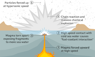
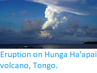
Three people, including a British citizen, have been confirmed dead and many more are missing following a tsunani that swept across the island nation of Tonga on Saturday 15 January 2022, following an eruption on the Hunga Ha'apai volcano. The volcano, which is usually underwater and is about 65 km to the north of the nation's capital, Nukuʻalofa, began erupting on 20 December 2021, producing a small island by the first week of January. However, on 15 January the centre of this island sank abruptly beneath the sea about two hours before the eruption. Vulcanologists have hypothesised that the eruption was caused by the collapse of a magma chamber, allowing seawater to come into contact with the hot magma, and triggering a phreatic explosion (rapid expansion of gas as a large volume of water turns to vapour more-or-less instantly).

 
Devastation on Tonga caused by the 15 January 2022 tsunami. Consulate of the Kingdom of Tonga.

Following the explosion a huge wave swept across the islands of Tonga, then out across the Pacific Ocean, reaching Australia and New Zealand in four hours, Japan in eight hours, California in ten hours and Alaska in eleven. Ths islands of Tonga suffered extensive damage, which destroyed much of the nation's communications infrastructure, with the extent of the destruction only becoming clear as ships from the New Zealand Navy reached the area several days later. As well as the obvious problems caused by the devastation of the nation's infrastructure, much of the area has been covered by sulphur-rich volcanic dust, which can be harmful if breathed in, and can react with fresh water to form sulphuric acid, threatening drinking water supplies. 

 
How a submarine phraetic explosion can cause a tsunami. BBC.

Hunga Ha’apai lies on the Tonga/Kermadec Ridge, and is fed by the subduction of the Pacific Plate beneath the Australian Plate along the Kermadec/Tonga Trench. As the Pacific Plate sinks into the Earth, it is warmed by the heat from the planets interior. This leads to partial melting of the Pacific Plate, with some of the melted material rising through the overlying Australian Plate as magma, fuelling the volcanos of the Kermadec/Tonga Ridge.

 
Diagram showing subduction along the Tonga Trench, and how this feeds the volcanoes of the Tonga Volcanic Arc. York University.

See also...


Follow Sciency Thoughts on Facebook.

Follow Sciency Thoughts on Twitter.


Thursday, 14 December 2017

Phreatic eruptions on Mount Kanlaon, Negros Island.

The Philippine Institute of Volcanology and Seismology reported a series of phreatic eruptions (explosions caused by magma or other hot volcanic material coming into contact with water) on Mount Kanlaon, a 2465 m stratovolcano (cone shaped volcano made up of layers of ash and lava) on northern Negros Island in the central Philippines, between about 9.45 and 10.00 am local time on Saturday 9 December 2017. These eruptions were heard as far away as La Castellana, roughly 25 km to the southwest, and produced a column of ash and steam that rose 3-4 km above the summit of the volcano, with ashfalls recorded in the communities of Guintubdan, Ara-al, Sag-ang, and Ilihan.

Column of ash and steam over Mount Kanlaon, Negros Island, on 9 December 2017. GMA News.

The volcano has remained active since this event, with 578 seismic tremors recorded beneath it between 8.00 am on Tuesday 12 and Wednesday 13 December. Seismic activity beneath volcanoes can be significant, as they are often caused by the arrival of fresh magma, which may indicate that a volcano is about to undergo an eruptive episode.

The approximate location of Mount Kanloan. Google Maps.

The geology of the Philippines is complex, with the majority of the islands located on the east of the Sunda Plate. To the east of this lies the Philippine Sea plate, which is being subducted beneath the Sunda Plate (a breakaway part of the Eurasian Plate); further east, in the Mariana Islands, the Pacific Plate is being subducted beneath the Philippine Sea Plate. This is not a smooth process, and the rocks of the tectonic plates frequently stick together before eventually being broken apart by the rising pressure, leading to Earthquakes in the process. Material from the subducting Philippine Plate is heated by the temperature of the Earth's interior, causing lighter minerals to melt and the resultant magma to rise through the overlying Sunda Plate, fuelling the volcanoes of the Philippines.

 Subduction beneath the Philippines. Yves Descatoire/Singapore Earth Observatory.
 
See also...

http://sciencythoughts.blogspot.co.uk/2017/11/landslides-kills-two-on-luzon-island.htmlhttp://sciencythoughts.blogspot.co.uk/2017/11/landslide-kills-man-in-camarines-sur.html
http://sciencythoughts.blogspot.co.uk/2017/10/magnitude-54-earthquake-in-batangas.htmlhttp://sciencythoughts.blogspot.co.uk/2017/10/landslide-kills-man-in-cebu-city.html
http://sciencythoughts.blogspot.co.uk/2017/09/one-killed-in-landslide-and-three-in.htmlhttp://sciencythoughts.blogspot.co.uk/2017/09/landslide-kills-two-in-cebu-city.html
Follow Sciency Thoughts on Facebook.

Tuesday, 30 June 2015

Japan restricts access to Mount Hakone after small eruption.

Authorities in Japan have closed off part of Mount Hakone, a popular tourist resort in Kanagawa Prefecture with hot springs and views of Mount Fuji, following a small eruption on Monday 29 June 2015. Nobody was injured in the event, in which a small amount of ash was produced slightly before 7.00 am, and was preceded by a Magnitude 3.3 Earthquake, but about 40 people were evacuated from the area due to the possibility of a phreatic eruption (explosion caused by water coming into contact with hot lava and vapourising).

Ash cloud over Mount Hakone. Reuters.

The Hakone area is noted for its hot springs, which are caused by water coming into contact with burried hot rocks, then rising to the surface, however Earthquakes near volcanoes are often caused by liquid magma moving through chambers beneath the volcano, and can be symptoms of future eruptions. In the case of Hakone there is a concern that magma closerto the surface my come into contact with liquid water, leading to explosions capable of throwing debris into the air at the surface.

The location of Mount Hakone. Google Maps.

Japan has a complex tectonic situation, with parts of the country on four different tectonic plates. Eastern Honshu area lies on the boundary between the Pacific, Eurasian and Philipine Plates, where the Pacific Plate is passing beneath the Eurasian and Philipine Plates as it is subducted into the Earth. This is not a smooth process; the rocks of the two plates constantly stick together, only to break apart again as the pressure builds up, causing Earthquakes in the process. 

The movement of the Pacific and Philippine Plates beneath eastern Honshu.Laurent Jolivet/Institut des Sciences de la Terre d'Orléans/Sciences de la Terre et de l'Environnement.

Mount Hakone is located directly on the Bonin Arc, a chain of volcanoes fed by liquified material from the Pacific Plate which is melted by the heat of the Earth's interior and rises through the overlying Eurasian Plate.

See also...

Authorities in Kanagawa Prefecture have closed off an area of Mount Hakone, a popular tourist destination, following a rise sharp in seismic activities since 26 April 2015. An area of around 300 m around the...


The Japan Meteorological Agency (which also monitors seismic activity) recorded a Magnitude 5.7 Earthquake at a depth of 50 km off the coast of Iwate Prefecture, slightly after 1.45 pm Japan Standard Time (slightly after 4.45 am GMT) on Tuesday 17 February 2015. There...


The Japan Meteorological Agency (which also monitors seismic activity) recorded a Magnitude 6.8 Earthquake at a depth of 10 km in Nagano...

Follow Sciency Thoughts on Facebook.

Thursday, 25 June 2015

Eruptions on Mount Bulusan.

Mount Bulusan, a 1565 m stratovolcano (cone shaped volcano made up of layers of ash and lava) on the southern tip of the Bicol Peninsula on Luzon Island, in the Philippines, began erupting slightly after 9.45 am local time on Friday 1 May 2015, with a small explosive eruption producing an ash column that rose 250 m above the summit of the volcano. This was the first eruption on the mountain since May 2012, though a series of small Earthquakes (often indicative of magma moving into chambers beneath a volcano) were reported under Mount Bulusan in July 2014. A second small eruption occurred later that day, along with a series of Earthquakes beneath the mountain, causing the Philippine Institute of Volcanology and Seismology to issue a warning against people entering the 'permanent danger zone' around the volcano, which in the case of Mount Bulusan extends 4 km from the summit due to the danger of lahars (extremely rapid floods of ash-laden mud).

An ash column over Mount Bulusan on 21 June 2015. Benedict Del Valle Ocampo/Facebook/Earth on Fire.

Slightly after 9.45 pm local time on Wednesday 6 May a small explosion was recorded in a vent on the northwest flank of the volcano, again producing a 250 m ash column. This was determined to have been phreatic in origin, i.e. caused by hot magma coming into contact with liquid water. Small ash-falls were recorded by several local communities, and steam was observed to be emitted from several other vents on the flanks of the volcano.

Ash column produced by an explosive eruption on Mount Bulusan on 16 June 2015. Ronald Belleza/Bicol Today.

A series of small Earthquakes and steam emissions were recorded from Mount Bulusan between 13 and 19 May, but no further eruptions. Then on 16 June a 10 minute eruption occurred slightly after 11.00 am, this also being thought to be phreatic in origin, and producing an ash column 1 km high. A second smaller eruption was recorded at about 11.20 am local time, combined with a series of small Earthquakes. Another small explosive eruption was recorded close to the summit of Mount Bulusan on Thursday 18 June, and on Friday 19 June a seven minute eruption starting at about 2.45 pm local time created a 1.5 km ash column that drifted to the west, causing ash falls in several local communities. A smaller eruption later that afternoon caused a 250 m ash column which drifted to the southwest. A small eruption at about 1.15 pm local time on Sunday 21 June produced a 150 m ash-and-stream plume that drifted to the east. Ash falls were also recorded by several local communities from this event. Another small eruption was recorded slightly before 10.10 pm local time on Tuesday 23 June.

The location of Mount Bulusan. Google Maps.

The geology of the Philippines is complex, with the majority of the islands located on the east of the Sunda Plate. To the east of this lies the Philippine Sea plate, which is being subducted beneath the Sunda Plate (a breakaway part of the Eurasian Plate); further east, in the Mariana Islands, the Pacific Plate is being subducted beneath the Philippine Sea Plate. This is not a smooth process, and the rocks of the tectonic plates frequently stick together before eventually being broken apart by the rising pressure, leading to Earthquakes in the process. Material from the subducting Philippine Plate is heated by the temperature of the Earth's interior, causing lighter minerals to melt and the resultant magma to rise through the overlying Sunda Plate, fueling the volcanoes of the Philippines.

Subduction beneath the Philippines. Yves Descatoire/Singapore Earth Observatory.

See also...

The United States Geological Survey recorded a Magnitude 5.3 Earthquake at a depth of 10 km about 37 km off the east coast of Luzon Island in the...


The Philippine Institute of Volcanology and Seismology has recorded an increase in seismic activity over the past 24 hours (Saturday 28-Sunday 29 June 2014) beneath Mount Mayon, a 2463 m stratovolcano (cone shaped volcano) on southern Luzon Island. White smoke has also been seen...


ive people are reported to have been killed in an eruption on Mount Mayon, an active stratovolcano (cone shaped volcano) on Luzon Island in the Philippines...


Follow Sciency Thoughts on Facebook.

Saturday, 6 June 2015

Kuchinoerabu Island evacuated following eruption on Shindake Volcano.

Shindake Volcano, on the island of Kuchinoerabu in the northern Ryukyu Islands, began to erupt suddenly slightly before 10.00 am local time on Friday 29 May 2015, when a loud explosion, thought to be a phreatic event (explosion caused by hot magma coming into contact with liquid water and vaporizing it instantly) was heard, followed by the production of a 9 km high ash plume that drifted to the southeast. A number of small pyroclastic flows (avalanches of hot gas and ash) were detected on the southwest and northwest flanks of the volcano, with those on the northwest observed to reach the sea. Local authorities ordered the evacuation of all 141 people present on the island at the time (about a hundred locals and a few visitors) as a precaution, and only a single injury was reported, an elderly man who received minor burns (it is unclear if this was caused directly by the volcano or some accident during the evacuation). Following the evacuations the volcano has been monitored closely, with a 1.2 km ash column observed on 30 May and several small pyroclastic flows on the northwest, southwest and southeastern flanks of the volcano.

Ash column over Kuchinoerabu Island on 29 May 2015, observed from the neighbouring island of Yakushima. Itaru Takaku/Kyodo News.

Japan has a complex tectonic environment with four plates underlying parts of the Islands; the Pacific in the east and the Othorsk in the North, there are the Philipine Plate to the south and the Eurasian Plate to the West. All of these plates are moving in different directions, and some subducting beneath the islands, leaning to a complex tectonic situation where earthquakes and volcanoes are common.

The location of Kuchinoerabu Island. Google Maps.

Kuchinoerabujima lies at the northeast end of the Ryukyu Island Arc, which sits on top of the boundary between the Eurasian and Philippine Plates. The Philippine Plate is being subducted beneath the Eurasian Plate, in the Ryukyo Trench, to the Southeast of the Islands. As it is drawn into the interior of the Earth, the tectonic plate is partially melted by the heat of the Earth's interior, and liquid magma rises up through the overlying Eurasian Plate to form the volcanos of the Ryukyu Islands and Kyūshū.

See also...

The Japan Meteorological Agency recorded an eruption on Mount Furudake on Kuchinoerabujima, an island about 130 km south of Kagoshima, at about 12.25 pm local time on Sunday 3 August 2014. The eruption consisted of a single powerful explosion followed by...


On 9 August 2013 the Japan Meteorological Agency reported a 50 minute eruption on Sakurajima Volcano, which is one of Japan's most active and sits on an island in Kagoshima Bay, Kyushu Island, which produced a 3.5 km high ash column, as well as...


The Tokyo Volcanic Ash Advisory Center reported that a 1.5 km ash plume was sighted over Suwanosejima on 3 July 2013. Such events are frequent on Suwanosejima, a sparsely inhabited 8 km...


Follow Sciency Thoughts on Facebook.

Friday, 8 May 2015

Alert level around Mount Hakone raised amid fears of a phraetic erruption.

Authorities in Kanagawa Prefecture have closed off an area of Mount Hakone, a popular tourist destination, following a rise sharp in seismic activities since 26 April 2015. An area of around 300 m around the Oowakudani Vent, as authorities are concerned about the possibilities of a phraetic eruption (explosion caused by water coming into contact with hot lava and vapourising). The Hakone area is noted for its hot springs, which are caused by water coming into contact with burried hot rocks, then rising to the surface, however Earthquakes near volcanoes are often caused by liquid magma moving through chambers beneath the volcano, and can be symptoms of future eruptions. In the case of Hakone there is a concern that magma closerto the surface my come into contact with liquid water, leading to explosions capable of throwing debris into the air at the surface.

 Steam burst at a hot spring in the Owakudani hot spring district of Mt. Hakone on 6 May 2015. Such bursts are common in the area, but have become larger and more frequent in the past week, wich may be a sign of liquid magma close to the surface. Kyodo News.

Japan has a complex tectonic situation, with parts of the country on four different tectonic plates. Eastern Honshu area lies on the boundary between the Pacific, Eurasian and Philipine Plates, where the Pacific Plate is passing beneath the Eurasian and Philipine Plates as it is subducted into the Earth. This is not a smooth process; the rocks of the two plates constantly stick together, only to break apart again as the pressure builds up, causing Earthquakes in the process. 
 The approximate location of Mount Hakone. Google Maps.
Mount Hakone is located directly on the Bonin Arc, a chain of volcanoes fed by liquified material from the Pacific Plate which is melted by the heat of the Earth's interior and rises through the overlying Eurasian Plate.
 The movement of the Pacific and Philippine Plates beneath eastern Honshu. Laurent Jolivet/Institut des Sciences de la Terre d'Orléans/Sciences de la Terre et de l'Environnement.
 
See also...

http://sciencythoughts.blogspot.co.uk/2015/02/magnitude-57-earthquake-off-east-coast.htmlMagnitude 5.7 Earthquake off the east coast of Honshū Island, Japan.                                  The Japan Meteorological Agency (which also monitors seismic activity) recorded a Magnitude 5.7 Earthquake at a depth of 50 km off the coast of Iwate Prefecture, slightly after 1.45 pm Japan Standard Time (slightly after 4.45 am GMT) on Tuesday 17 February 2015. There...
http://sciencythoughts.blogspot.co.uk/2014/11/magnitude-68-earthquake-in-nagano.htmlMagnitude 6.8 Earthquake in Nagano Prefecture, Japan.                                                 The Japan Meteorological Agency (which also monitors seismic activity) recorded a Magnitude 6.8 Earthquake at a depth of 10 km in Nagano...
Ten people have been confirmed dead and 63 have been injured following an unpredicted eruption of Mount Ontake on central Honshū on Saturday 27 September 2014. At least 26 people remain...

Follow Sciency Thoughts on Facebook.