Showing posts with label Explorer Plate. Show all posts

Tuesday, 23 October 2018

Three major Earthquakes off the west coast of British Columbia.

Natural Resources Canada recorded a series of three Earthquakes at a depth of 10 km about 200 km off the west coast of British Columbia on 21/22 October 2018, with the first occurring slightly before 10.40 pm local time on Sunday 21 October (slightly before 5.40 am on Monday 22 October GMT), and having a Magnitude of 6.5 , the second occurring slightly after 11.15 pm local time (slightly after 6.15 am GMT), and having a Magnitude of 6.8, and the third occurring slightly after 11.20 pm local time (slightly after 6.20 am GMT) and having a Magnitude of 6.5. These events were felt along much of the coast of British Columbia and Washington State, but there are no reports of any damage or casualties.

The approximate location of the 21/22 October 2018 British Columbia Earthquakes. USGS.

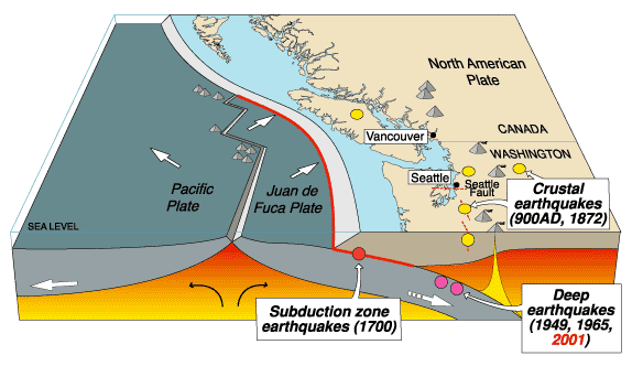
Vancouver Island is located on the western margin of the North American Plate, close to the Challenger Trench, along which the Explorer and Juan de Fuca Plate are being subducted. These are two remnant parts of the ancient Farallon Plate, which formerly underlay part of the eastern Pacific, and which has now been largely subducted beneath North America. The Explorer an Juan de Fuca Plates pass under the North American Plate as they sink into the Earth, but this is not a smooth process, with the plates constantly sticking together then breaking apart as the tectonic stresses build up.
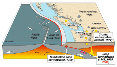
 The subduction of the Juan de Fuca Plate beneath North America. United States Geological Survey.

On this occasion the Earthquake occurred on the northern part of the Juan de Fuca Plate, close to the Juan de Fuca Ridge. The Juan de Fuca ridge marks the extensional margin between the Juan de Fuca Plate and the Pacific Plate. The Juan de Fuca Plate is thought to be a remnant of an ancient plate known as the Farallon Plate, a once vast plate now largely subducted beneath the North American Plate. There are three remnants of this plate remaining off the west coast of the US; the Juan de Fuca Plate, the Gorda Plate to the south and the Explorer Plate to the north. The Juan de Fuca Ridge was once part of the longer Farallon Ridge, which ran along the eastern margin of the Farallon Ridge before it was fractured into three parts.

 Spreading on the Juan de Fuca Ridge, and its relationship to the volcanoes of the North American west coast. Wikimedia Commons.

Witness reports can help geologists to understand the processes going on in Earthquakes and the structures in the rocks that cause them. If you felt any of these quakes you can report it to Natural Resources Canada here.

See also...

https://sciencythoughts.blogspot.com/2018/05/homes-evacuated-due-to-wildfires-in.htmlhttps://sciencythoughts.blogspot.com/2018/05/canadian-couple-survive-being-swept-of.html
https://sciencythoughts.blogspot.com/2018/03/avalanche-kills-skier-in-british.htmlhttps://sciencythoughts.blogspot.com/2018/02/british-colombia-avalache-victim-dies.html
https://sciencythoughts.blogspot.com/2018/01/homes-evacuated-after-landslide-in.htmlhttps://sciencythoughts.blogspot.com/2017/05/magnitude-62-earthquake-in-northwest.html
Follow Sciency Thoughts on Facebook.

Saturday, 24 October 2015

Magnitude 4.4 Earthquake off the coast of British Columbia.

The West Coast and Alaska Tsunami Warning Center reported a Magnitude 4.4 Earthquake roughly 90 km off the northwest tip of Vancouver Island, British Columbia, slightly before 4.10 pm local time (slightly before 11.10 pm GMT) on Thursday 22 October 2015. There are no reports of any damage or casualties associated with this event, but people have reported feeling it on Vancouver Island.

The approximate location of the 22 October 2015 British Columbia Earthquake.Google Maps.

Vancouver Island is located on the western margin of the North American Plate, close to the Challenger Trench, along which the Explorer and Juan de Fuca Plate are being subducted. These are two remnant parts of the ancient Farallon Plate, which formerly underlay part of the eastern Pacific, and which has now been largely subducted beneath North America. The Explorer an Juan de Fuca Plates pass under the North American Plate as they sink into the Earth, but this is not a smooth process, with the plates constantly sticking together then breaking apart as the tectonic stresses build up.

The subduction of the Juan de Fuca Plate beneath North America. United States Geological Survey.

Witness accounts of Earthquakes can help geologists to understand these events, and the structures that cause them. The international non-profit organization Earthquake Report is interested in hearing from people who may have felt this event; if you felt this quake then you can report it to Earthquake Report here.

See also...

A mine tailings pond at the Imperial Metals operated Mount Polley Mine, an open-pit copper mine in the Cariboo Region of British Columbia was breached on Monday 4 August 2014 after...


Two people were injured when part of a cliff collapsed onto Highway 97 in British Columbia, about 6 km north of Summerland, at about 11.30 am local time on Sunday 6 July 2014. The pair, thought to be a couple in their 60s from Alberta, were taken to a local hospital for...


The Natural Resources Canada reported a Magnitude 6.6 Earthquake roughly 20 km off the southwest coast of Vancouver Island, British Columbia, at about...


Follow Sciency Thoughts on Facebook.

Thursday, 24 April 2014

Magnitude 6.6 Earthquake off the southwest coast of Vancouver Island.

The Natural Resources Canada reported a Magnitude 6.6 Earthquake roughly 20 km off the southwest coast of Vancouver Island, British Columbia, at about 8.10 pm local time on Wednesday 23 April 2014 (about 3.10 am on Thursday 24 April, GMT). This is a large quake, and was felt across much of southern British Columbia and northwest Washington State, although there are no reports of any damage or casualties, and no tsunami warning was issued.

The approximate location of the 23 April 2014 Vancouver Island Earthquake. Google Maps.

Vancouver Island is located on the western margin of the North American Plate, close to the Challenger Trench, along which the Explorer and Juan de Fuca Plate are being subducted. These are two remnant parts of the ancient Farallon Plate, which formerly underlay part of the eastern Pacific, and which has now been largely subducted beneath North America. The Explorer an Juan de Fuca Plates pass under the North American Plate as they sink into the Earth, but this is not a smooth process, with the plates constantly sticking together then breaking apart as the tectonic stresses build up.

The subduction of the Juan de Fuca Plate beneath North America. United States Geological Survey.

Witness reports can help geologists to understand the processes going on in Earthquakes and the structures in the rocks that cause them. If you felt this quake you can report it to Natural Resources Canada here.

See also...


Follow Sciency Thoughts on Facebook.

Wednesday, 4 September 2013

Magnitude 6.2 Earthquake of the coast of British Columbia.

Natural Resources Canada recorded a Magnitude 6.2 Earthquake roughly 200 km off the coast of British Columbia slightly before 1.20 pm local time (slightly before 8.20 pm GMT) on Tuesday 3 September 2013. This is a large quake and would be potentially quite dangerous in an inhabited area, but occurred significantly offshore and no witness reports have been made, though it is possible it was felt in coastal areas by people who have not come forward. No tsunami warning was issued for this quake, which has been followed by at least five aftershocks with Magnitudes between 4 and 6.

The approximate location of the 3 September 2013 British Columbia Earthquake. Google Maps.

British Columbia is located on the western margin of the North American Plate, close to the Challenger Trench, along which the Explorer and Juan de Fuca Plate are being subducted. These are two remnant parts of the ancient Farallon Plate, which formerly underlay part of the eastern Pacific, and which has now been largely subducted beneath North America. The Explorer an Juan de Fuca Plates pass under the North American Plate as they sink into the Earth, but this is not a smooth process, with the plates constantly sticking together then breaking apart as the tectonic stresses build up.

Witness reports can help geologists to understand the processes going on in Earthquakes and the structures in the rocks that cause them. If you felt this quake you can report it to Natural Resources Canada here.


Follow Sciency Thoughts on Facebook.

Monday, 5 August 2013

Magnitude 5.3 Earthquake shakes Vancouver Island.

A Magnitude 5.5 Earthquake occurred off the southeast coast of Vancouver Island in British Columbia, slightly after 6.20 am local time (slightly after 1.20 pm GMT) on Sunday 4 August 2013, according to Natural Resources Canada. The quake was felt across much of the island, but there are no reports of any damage or casualties, and no tsunami warning has been issued.

The approximate location of the 4 August 2012 Vancouver Island Earthquake. Google Maps.

Vancouver Island is located on the western margin of the North American Plate, close to the Challenger Trench, along which the Explorer and Juan de Fuca Plate are being subducted. These are two remnant parts of the ancient Farallon Plate, which formerly underlay part of the eastern Pacific, and which has now been largely subducted beneath North America. The Explorer an Juan de Fuca Plates pass under the North American Plate as they sink into the Earth, but this is not a smooth process, with the plates constantly sticking together then breaking apart as the tectonic stresses build up.

Witness reports can help geologists to understand the processes going on in Earthquakes and the structures in the rocks that cause them. If you felt this quake you can report it to Natural Resources Canada here.


Follow Sciency Thoughts on Facebook.

Saturday, 10 November 2012

Earthquake off Vancouver Island.

On Wednesday 8 November 2012, slightly after 2.00 am local time (slightly after 6.00 pm on Thursday 7 November, GMT) the United States Geological Survey recorded a magnitude 6.3 Earthquake at a depth of 16.6 km, roughly 120 km off the southwest coast of Vancouver Island, British Columbia. This is a large quake and would potentially be very dangerous in an inhabited area, but it happened a long way off shore, and at an hour when most human beings were asleep, so there was no damage or casualties and only a few people on Vancouver Island felt the quake.

Map showing the location of the 8 November quake. Google Maps.

Vancouver Island is located on the western margin of the North American Plate, close to the Challenger Trench, along which the Explorer and Juan de Fuca Plate are being subducted. These are two remnant parts of the ancient Farallon Plate, which formerly underlay part of the eastern Pacific, and which has now been largely subducted beneath North America. The Explorer an Juan de Fuca Plates pass under the North American Plate as they sink into the Earth, but this is not a smooth process, with the plates constantly sticking together then breaking apart as the tectonic stresses build up.

Diagrammatic representation of the subduction of the Explorer and Juan de Fuca Plates beneath the North American Plate, close to Vancouver Island. Black Stars show major historic Earthquakes. Government of British Columbia.

Witness reports can help geologists to understand the processes going on in Earthquakes and the structures in the rocks that cause them. If you felt this quake you can report it to Natural Resources Canada here.


Follow Sciency Thoughts on Facebook.
Wednesday, 10 August 2011

Scientists predict eruption of Axial Seamount. August 2011.

Axial Seamount is a submarine volcano located on the Juan de Fuca Ridge, 480 km west of the Oregon Coast. It has been the subject of extensive study as it is extremely active and is of complex origins: it is on the intersection of the Cobb Hotspot Seamount Chain, and the Juan de Fuca extensional ridge; it is also close to the Blanco Fracture Zone. The seamount rises 700 m above the rest of the Juan de Fuca Ridge and about 1100 m above the surrounding sea floor; it is 1400 m bellow the sea surface. It is a biodiversity hotspot, hosting several 'black-smokers' - underwater hot springs producing super-heated mineral rich water, which support unique ecosystems.

The location of the Axial Seamount.


The Juan de Fuca Ridge, including Axial Seamount, was discovered by the SEASAT satellite using satellite alimentary, a technique which bounces radio-waves of the sea-floor to build up a three dimensional picture. SEASAT was a satellite launched by NASA's Jet Propulsion Laboratory in 1978. It carried a range of instruments intended to study and monitor the world's oceans. Its mission was short-lived, being cut off by a massive short-circuit 105 days after its launch.

In 1981 the National Oceanic and Atmospheric Administration (NOAA) Survey Ship Surveyor carried out a bathymetric study of the area using ship mounted sonar and thermal mapping equipment. This identified a number of thermal hotspots.

In 1983 the ridge was explored by the NOAAs submersible Pisces IV and 1984 by the Woods Hole Oceanographic Institution's DSV Alvin, between them discovering a number of black smokers. The Axial Seamount was named for its position on the intersection (Axis) between the Juan de Fuca Ridge and the Cobb Seamount Chain.

The DSV Alvin.

The seamount was further investigated by the NOASS Discoverer in 1991 and the German research ship RV Sonne in 1996. Later in 1996 the NOAA founded the New Millennium Observatory at Mount Axial, the first ever permanent monitoring station at a submarine volcano.

In January 1998 this reported a marine eruption on the site; when the site was visited in February it was found that there had indeed been an eruption, burying some of the station's equipment but confirming that the station was indeed able to detect eruptions.

In 2006 Bill Chadwick of the Hatfield Marine Science Center at Oregon State University and Scott Nooner of the Lamont-Doherty Earth Observatory at Columbia University published a paper in the Journal of Volcanology and Geothermal Research in which they analyzed movements on the sea-floor before and after the 1998 eruption, and found that there had been a long period of inflation prior to the eruption, followed by an abrupt deflation of the sea-floor during the eruption, with 3.2 m of subsidence. They then analyzed more recent data from the seamount and found that the sea-floor was once again swelling. From this they concluded that Axial Seamount was likely to erupt again within 8 years.

In April this year (2011) monitors on the seamount once again detected signs of an eruption, and in late July a visit by the Woods Hole Oceanographic Institutions ship RV Atlantis revealed that there had indeed been an eruption, with extensive lava flows, already showing signs of new colonization by benthic animals.

The Juan de Fuca ridge marks the extensional margin between the Juan de Fuca Plate and the Pacific Plate. The Juan de Fuca Plate is thought to be a remnant of an ancient plate known as the Farallon Plate, a once vast plate now largely subducted beneath the North American Plate. There are three remnants of this plate remaining off the west coast of the US; the Juan de Fuca Plate, the Gorda Plate to the south and the Explorer Plate to the north. The Juan de Fuca Ridge was once part of the longer Farallon Ridge, which ran along the eastern margin of the Farallon Ridge before it was fractured into three parts.

The former parts of the Farallon Plate.

The Cobb Seamount Chain runs from the Aleutian Trench off the south coast of Alaska south to Axial Seamount. It is gets its name from the Cobb Seamount, which is 500 km west of the Washington coast, and was named after the research vessel MV John M Cobb; this can cause some confusion as other objects on the seafloor of the NE Pacific are also named after this vessel (Cobb) and are not necessarily related to the seamount chain.

The Cobb Seamount Chain, top right.