Showing posts with label Middle Stone Age. Show all posts

Wednesday, 17 April 2024

Earlier and Middle Stone Age tools from Egypt's Eastern Desert.

During the Pleistocene interglacial phases, Hominin and Human groups migrated out of Africa and into Asia through Egypt. For a long while it was presumed that the main route of migration was along the Nile, but in recent years it has become increasingly apparent that the Eastern Desert was also a significant migration route, although little is known about the populations that inhabited this region.

In a paper published in the journal AntiquityAlice Leplongeon of the Center for Archaeological Research of Landscapes at KU Leuven, the Department of Anthropology at the University of Connecticut, and Histoire Naturelle de l’Homme Préhistorique and the Muséum National d’Histoire Naturelle at the Université de Perpignan Via DomitiaMaxence Bailly of the Maison méditerranéenne des sciences de l’homme at Aix Marseille Université, and Gwenola Graff of the Département Homme et Environnement at the Muséum national d’Histoire naturelle, report on a series of new Earlier Stone Age and Middle Stone Age finds in the Wadi Abu Subeira area of the Eastern Desert.

During 2022, Leplongeon et al. mapped 22 new sites, including single artefact sites, sites with scatters of stone tools, and workshops where stone was worked.  All were found either on plateaux tops or plateaux slopes, never in the wadis that separate the plateaux The isolated tools included a large symmetrical handaxe and a cleaver made from coarse ferruginous sandstone. Scatters of artefacts appear to have no pattern to them; the largest being over 500 m long, with an artefact density of between 0 and 10 artefacts per square meter. Tools were made from a variety of rock types, including quartz, silicified wood, silicified sandstone and chert. Of these, only quartz was available in the immediate area, although the other materials could often be found in wadi bottoms or on nearby plateaux. The items were a mixture of Earlier Stone Age tools, such as large axes, and Middle Stone Age tools, such as Levallois cores, probably representing an accumulation of items which had built up over a long period of time, and reflecting several distinct phases of occupation at the same sites, as well as, in places, accumulations of items caused by erosion.

Earlier Stone Age isolated finds: (A) & (B) context and photograph of cleaver L652; (C) & (D) handaxe L672. Leplongeon et al. (2024).

Leplongeon et al. identified five workshops where stone tools were manufactured, each comprising an accumulation of lithic artefacts next to a ferruginous sandstone, although the nature of this sandstone otherwise varied considerably. The highest density of artifacts was found at a workshop on a site referred to as the 'Leaf Plateaux', where there were more than 50 artefacts per meter squared, adjacent to outcrops of fine-grained red and yellow ferruginous sandstone. Blocks of material had apparently been broken from the outcrops, then reduced using a variety of knapping techniques. These include several Levallois cores, as well as blade cores and a few retouched tools including two bifacial points, indicating that this site is of Middle Stone Age origin. 

Middle Stone Age lithic workshop (L618-623). Overview (A) and detail (B) of an area of the workshop; (C) extraction face; (D) Levallois core; (E) bifacial point. Leplongeon et al. (2024).

About 800 m to the east of this Middle Stone Age workshop, an outcrop of a coarser type of ferruginous sandstone, another workshop yielded several large centripetally flaked cores and several handaxes and preforms. All of the artefacts here had a dark desert varnish (indicating age), and appeared attributable to an Acheulean technology. Acheulean sites are rare in northeast Africa, making this a significant discovery.

Earlier Stone Age lithic workshop (L602–603). (A) overview of the site with the two main concentrations of artefacts; (B) detail of area 2; (C) large centripetal core; (D) handaxe preform. Leplongeon et al. (2024).

The presence of two workshops from very different periods shows repeated utilisation of outcrops in the area by different waves of inhabitants, but also that these different peoples with different technologies selected slightly different types of stone as most ideal for their purposes. Notably, workshops and artefact clusters appear to be particularly connected to outcrops of the Nubia Sandstone and in particular the Timsah Formation, suggesting that ancient inhabitants of the Wadi Abu Subeira were capable of following a particular geological formation, apparently for the workable qualities of this material.

See also...

Sunday, 5 November 2023

Evidence for shoes in the Middle Stone Age of the Cape Coast, South Africa.

The appearance of clothing is considered to be one of the key stages in the development of Modern Humans, and the development of footwear, a complex form of clothing, is in itself an important technological leap. However, the exact time when footwear first appeared is unknown, with the first foot-coverings presumed to have been made of perishable materials unlikely to have survived. In the absence of preserved footwear, ichnology (the study of tracks and traces) provides the most plausible technique for detecting the first use of footwear among Hominins.

The oldest known shoes in the archaeological record are sandals made of woven Sagebrush bark from Oregon in the United States, the oldest of which have been dated to between 10 500 and 9200 years old. Also from the United States, a variety of sandals, moccasins, and slip-on footwear have been uncovered in Missouri, dating from between 8000 and 1000 years ago. The oldest shoe from Eurasia is a leather wrap-around shoe from southeastern Armenia, dated to between 5600 and 5400 years ago. Also from Eurasia, ‘Ötzi the Iceman' a frozen natural mummy found in the High Alps on the border between Austria and Italy, dated to more than 5000 years old, had a complete set of clothing, including complex footwear made from Bear-skin, Deer hide, and tree bark. A pair of Cow-hide sandals from Israel has also been dated to more than 5000 years ago.

Hominin trackways are known from many sites around the world, and can be identified by features such as the alignment and shape of the hallux, relative digit lengths, and the presence of a prominent medial longitudinal arch. However, these identifying features are based upon the assumption that the track-maker was unshod, and it is unlikely that all would be present were they to have been wearing some form of foot-covering. Thus, unsurprisingly, the majority of known Hominin tracks are considered to have been made by unshod tracemakers, although a few exceptions are known.

The oldest apparently shod Human tracks in the Americas are in Jaguar Cave, Tennessee, which are thought to be about 5000 years old. In Europe such traces include traces associated with a Magdalenian (Upper Palaeolithic) tool assemblage in Fontanet Cave, France, which appear to have been made by an individual wearing a soft shoe or sock. Also in France, Cussac Cave, footprints associated with a Gravettian assemblage and dated to between 38 000 and 31 000 years ago lack any digit impressions, despite these being present on both Human handprints and Bear footprints within the same cave, leading to the possibility that the trace-makers may have been shod.

Footprints without digit impressions are also known from a third site in France, Le Rozel, although these are about 80 000 years old, implying that the trace-makers were Neanderthals rather than Modern Humans. Possible evidence for footwear use by Neanderthals comes from Theopetra Cave in Greece, where a mixture of shod and unshod traces appears to have been left by a group of children around 130 000 years ago.

In South Africa, a number of possible footwear traces have been found on the Cape Coast, an area noted for its excellent Pleistocene tracks, including one trace which appears to show a clear sandal-imprint.

The use of clothing is thought to have been developed by Hominins inhabiting cool environments during Pleistocene cold spells, although the perishable nature of the material from which such cloths are likely to have been made, makes it unlikely that any preserved material will ever be found. Instead, tools used for the processing of skins, leather, and textiles are used as proxies for the materials themselves. This begins with the appearance of scrapers presumed to have been used for the preparation of skins, shortly followed by bone awls, needles and eyed needles, which imply the manufacture of increasingly complex clothing. Based upon this, it has been calculated that the first simple clothing probably appeared around 800 000 years ago, long before the emergence of Modern Humans, with several different Hominin species probably manufacturing and wearing cloths, with the possibility that footwear appeared at the same time. Molecular clock analysis suggests that Body Lice probably diverged from Head Lice between 170 000 and 80 000 years ago, by which time is is assumed that Humans were habitually wearing cloths all the time.

The Contrebandiers Cave site in Morocco, which has been dated to between 120 000 and 90 000 years ago, has yielded a variety of bone tools thought to have been used for the processing of leather and furs, but for the most part Pleistocene sites with evidence for tools likely to have been used in clothing manufacture and tracks made by Hominins are restricted to two areas, Western Europe and the Cape Coast of South Africa.

Such tools in Europe are known from the Middle Palaeolithic of southwestern France, with the oldest dating to about 51 400 years ago, and other examples between 48 000 and 41 000 years ago. These tools were presumably made by Neanderthals, and include lissoirs, tools which can be used to process hides, giving a smooth, tough, and reasonably impermeable finish (although not the same as modern commercially produced leathers).

The oldest sites in South Africa yielding tools which could have been made for making cloths are at Klasies River and Blombos Cave on the Cape Coast, with the Klasies River site dated to about 100 000 years ago and Blombos Cave mostly to about 80 000 years ago, although one awl, made from the bone of a Bird, was dated to at least 125 000 years ago.

Although these tools are taken as the earliest tools which are clearly associated with clothing manufacture, in both Europe and South Africa earlier stone tools could have been used to cut or pierce hides during the manufacture of simple garments, as could sharpened shell tools known from the Cape Coast. However, the fact that the oldest surviving footwear was made from woven Sagebrush rather than leather does suggest that caution should be applied when judging what ancient populations would have seen as suitable materials for making footwear.

It has also been suggested that wearing shoes might affect the way in which the foot develops, something which has been implied for a set of Human remains from Tianyuan in China dated to about 50 000 years ago, although the phalanges of the foot are seldom well preserved, limiting the number of instances in which this method can be applied.

Another Upper Palaeolithic site at Sunghir, in northern Russia, yielded a buried individual with remnant body decoration implying leggings or boots, as well as having extremely gracile lateral phalanges, something thought to be associated with habitual shoe wearing. This was particularly surprising as all Upper Palaeolithic Hominin tracks from Eurasia appear to have been made by barefoot trace-makers.

The relationship between footwear and foot morphology is complicated. Individuals who minimise their use of footwear are thought to have stronger foot muscles, and fewer pathologies of the feet, but this would be unlikely to result in any detectable skeletal difference between someone who never wore shoes and someone who occasionally did so, or even somebody who habitually wore very lightweight shoes.

In a paper published in the journal Ichnos on 28 August 2023, Charles Helm of the African Centre for Coastal Palaeoscience at Nelson Mandela University, Martin Lockley, also of the African Centre for Coastal Palaeoscience at Nelson Mandela University, and of the Dinosaur Trackers Research Group at the University of Colorado Denver, Hayley Cawthra, again of the African Centre for Coastal Palaeoscience at Nelson Mandela University, and of the Minerals and Energy Unit at the South African Council for Geoscience, Jan De Vynck, again of the African Centre for Coastal Palaeoscience at Nelson Mandela University, and of the Evolutionary Studies Institute at the University of the Witwatersrand, Mark Dixon, again of the African Centre for Coastal Palaeoscience at Nelson Mandela University, Renée Rust, again of the African Centre for Coastal Palaeoscience at Nelson Mandela University, and of the School of Geography, Archaeology and Environmental Studies at the University of the Witwatersrand, Willo Stear and Monique Van Tonder, once again of the African Centre for Coastal Palaeoscience at Nelson Mandela University, and Bernhard Zipfel, also of the Evolutionary Studies Institute at the University of the Witwatersrand, describe three Middle Stone Age sites on South Africa’s Cape Coast where tracks appear to have been made by Hominins wearing shoes, and discuss ways in which future studies of this topic could be approached.

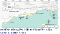
Map of the Cape Coast of South Africa, showing Cenozoic deposits and places mentioned in the text. Helm et al. (2023).

Scientists from the African Centre for Coastal Palaeoscience have been studying the trace fossils of the Cape Coast since 2007. Here, a 350 km section of coast has frequent coastal aeolianites (wind-blown sand deposits) which have been buried by subsequent similar deposits than set with a carbonate cement, preserving a record of the people and animals which moved over them during the Middle Stone Age. As well as trackways left by Hominins, these studies revealed imprints left by Crocodiles, Giraffe, breeding Sea Turtles and very large Tortoises, none of which have left skeletal remains in the area.

The Cape Coast region has a remarkably rich archaeological record, tracing the appearance and development of numerous stages considered key steps on the way to Modern Human behaviour, including personal adornments, jewellery, the heat treatment of stone tools, art, and the use of abstract symbols. Palaeoclimatic studies of the same region indicate that the coastal plains upon which these deposits were laid down went through a cycle of exposure and inundation throughout the Pleistocene, which probably helped to maintain an ideal Hominin environment in the region. 

Prior to this project, Hominin tracks had previously been discovered at Langebaan on the west coast of South Africa, and Nahoon on the east coast of the country. Extensive study of the Cape Coast has produced four new track localities, and while another probable set of tracks has recently been identified at Langebaan. Combined with a set of tracks on an ancient lakebed in the Nefud Desert of Saudi Arabia, this represents the entire global inventory of tracks more than 46 000 years old which are attributed to Modern Humans.

All of the Hominin tracks on the Cape Coast are within the aeolianites of the Waenhuiskrans Formation, which together with the cemented foreshore, shoreface and lagoon deposits of the Klein Brak Formation, comprise the Bredasdorp Group. These deposits have been dated to between 400 000 and 36 000 years old, although the majority belong to Marine Isotope Stage 5, making them between 130 000 and 80 000 years old. To the east of Robberg, the correlate of the Waenhuiskrans Formation is the Nahoon Formation, which forms part of the Algoa Group. These Pleistocene aeolianites split readily along their bedding planes, so that tracks are often exposed on fallen blocks on the coast. Thes blocks are ephemeral, quickly being eroded away by the action of the waves.

Due to this ephemeral nature, tracks needed to be recorded quickly when exposed. This was done by recording their locality with a GPS unit and taking numerous photographs, which were then used to build photogrammetric models. Exposed trackways and footprints were also measured for track length, track width, track depth, pace length, stride length, and thickness of foresets, and individual footprints were examined for evidence of strap attachment points. 

In addition, studies were made of newly created tracks on sandy surfaces on the Cape Coast, with varying levels of moisture, slope, and firmness, and a variety of shoe types, including shoes with an open soft sole, an open hard sole, a closed soft sole and a closed hard sole. The best match for the fossil footprints was made by using an open hard soled shoe on soft, moist sand.

Shoe designs for this study were based upon shoes made by examples of sandals made by San peoples of southern Africa from the collections of the Blombos Museum of Archaeology in South Africa and Zambezi Heritage Museum in Namibia. The shoe which gave the closest results to the preserves footprints was based upon two such sandals, and was made from two layers of Cow-hide glued together, and laced by piercing three holes through this sole, one between the big toe and the adjacent digit, and two about half way along the length of the shoe, one at each side. The laces were made from the same Cow-hide as the upper part of the shoe, and were threaded through the holes and knotted underneath, protruding below, although in the museum examples prolonged use had levelled out the knots with the base of the sole. These sandals proved easy to attach to the foot.

Helm et al. present details of three footprint-bearing sites on the Cape Coast, these being, from west to east, Kleinkrantz, Goukamma, and Woody Cape.

At Kleinkrantz a slab measing 55 cm x 55 cm and 20 cm thick with apparent footprints on its upper surface, was found lying on a modern coast dune beneath a vegetated slope, which in turn lies beneath a cliff with an exposure of the Waenhuiskrans Formation. There was no sign of a recent rockfall, and samples taken from the Waenhuiskrans Formation in this area have been dated to between 148 000 and 79 000 years old.

(A) The Kleinkrantz site in the Garden Route National Park; scale bar is 10 cm. (B) Photogrammetry colour mesh of the Kleinkrantz site, using 48 images. Photos were taken average 36.4 cm from the surface. The reprojection error is 0.39 pix. Vertical and horizontal scales are in metres. Arrows indicate possible strap attachment point impressions. Helm et al. (2023).

This slab has two similar depressions, one in front of the other, each with crisp three crisp and well-defined margins, two straight parallel, the third near semicircular. One of these appears to have been a double impression, with a slightly narrower impression overlying an slightly wider one. The wider of these is 9 cm wide, the narrower 7 cm, while the single impression is 8 cm wide. Both features are at least 16 cm long. The narrowest impression also has three depressions within it consistent with the position of the strap knots on the experimental sandal.

Two other possible track prints are also present, although these are more amorphous, and were apparently made by a person travelling in a different direction, though again possible strap-attachment knot impressions are present. 

The second site lies within the Goukamma Nature Reserve, between Sedgefield and Knysna, where the Waenhuiskrans Formation has been dated to between 136 000 and 79 000 years old, although recent dates obtained suggest parts of the formation may be as young as 73 000 years old. Here a fallen slab has three footprints with crisp margins and no signs of digits, one of which particularly resembles the imprint of a shod foot. This print measures 11.5 cm in length and 6 cm in width.

(A) The Goukamma surface; scale bar = 10 cm. (B) Angled view of the Goukamma site; scale bar is 10 cm. (C) Photogrammetry colour mesh of the Goukamma site, using 59 images. Photos were taken average 29.9 cm from the surface. The reprojection error is 0.39 pix. Vertical and horizontal scales are in metres. Helm et al. (2023).

The third site, Woody Cape, is situated in the coastal portion of the Addo Elephant National Park. Here a detached slab from the Nahoon Formation shows a trackway comprising four footprints, one of which is partial. The prints are 10-12 cm long and 5-6 cm wide, with a pace length of 19 cm. Raised areas to the left of each print imply some downslope movement.

Photogrammetry colour mesh of the Woody Cape site, using 37 images. Photos were taken average 29.2 cm from the surface. The reprojection error is 0.57 pix. Vertical and horizontal scales are in metres. Helm et al. (2023).

Helm et al. also attempted to recreate a trackway similar to the Pleistocene examples, using a hard-soled sandal based upon museum specimens, on a modern, moist, soft, level dune surface. This produced footprints with slight out-toeing about 26 cm in length, with a width of 11.5 cm and a pace length of 63 cm. The front and back margins of the prints were semicircular, the sides parallel. Strap attachment marks can be seen.

Photogrammetry colour mesh of the neoichnological trackway (level surface, hard-soled sandal, soft substrate) using 63 images. Photos were taken average 37 cm from the surface. The reprojection error is 2.07 pix. Vertical and horizontal scales are in metres. Helm et al. (2023).

Helm et al. accept that the evidence they provide cannot be seen as irrefutable, however, the presence of similar tracks at three separate sites, combined with the recreation of similar prints with a pair of modern sandals based upon a historic design, does strongly suggest that similar sandals were being worn by Humans in the area more than 70 000 years ago. All three sets of footprints appear to have been made by trackmakers smaller than modern adult Humans, suggesting that they were either adults of smaller stature, or children.

A pair of sandals on exhibit in the Blombos Museum of Archaeology in Still Bay, viewed from above (A), and below (B), showing strap attachment points; scale bars are 10 cm. Helm et al. (2023).

The tracks of bare feet are distinctive, due to the presence of digits and the raised arch of the foot. The impression likely to have been made by a shoe of unknown design is less easy to predict, but it is likely to have followed the general plan of a Hominin footprint, i.e. twice as long as wide, and soft foot-coverings may still preserve the presence of an arch, and rounded front and back margins. It is also quite likely that the front portion of the print will be wider than the rear portion, and that the curve of the front and back parts of the foot will be different. Trackways will reflect the fact that Hominins are bipeds with a narrow stride. In some cases, distinctive traces may be made by the footwear, such as attachment marks from straps.

A pair of sandals on exhibit in the Zambezi Heritage Museum in Katima Mulilo, Namibia, viewed from above (A), and below (B), showing strap attachment points; scale bars are 10 cm. Helm et al. (2023).

Previous attempts to recreate impressions likely to have been made by ancient footwear mostly concentrated on the use of soft leather shoes by persons walking over clay substrates. These studies found that shod tracks were typically longer and narrower than unshod tracks, and that this became more exaggerated as the substrate got moister and the footprints deeper. Shod footprints were also typically simpler than unshod ones, most obviously in the lack of toe-prints. 

These findings may have some implications for studies being carried out on the Cape Coast of South Africa, where some footprints have been considered questionable due to their apparently elongate shape.

Historic sandals in the collections of museums shed light on the appearance of shoes within the region in the recent past, and therefore possibly those that might have been used by people in the remote past armed with similar resources and environmental challenges. These sandals are remarkably symmetrical, with little difference between the width of the front and rear portions of the shoe. The pair from the Zambezi Heritage Museum in Namibia are believed to have been made from Buffalo hide in the 1920s.

The San people who made these sandals are known to have used a variety of Animal skins, with different groups using specific hides, including Eland, Hartebeest, and Wildebeest, while other Animals, such as Gemsbok, were avoided by all groups. Furthermore, different types of sandals were made for different purposes, including special shoes for seniors, shoes for uphill travel, and running sandals with a hook under the toe giving extra purchase when running over soft sand (possibly in imitation of the foot of an Ostrich, the fastest bipedal Animal present in the region).

A pair of ‘running sandals’ in the Fourie Collection in Museum Africa, accession number MM40-69-2416; scale bar is 10 cm. Justine Wintjes in Helm et al. (2023).

Rock art in Southern Africa also provides a record of the use of footwear in the region, albeit one that only stretches back a few thousand years. The artwork at Baviaanskloof in Eastern Cape Province is thought to be about 2000 years old, and includes a 21 cm high figure interpreted as a shaman, naked apart of a pair of laced sandals and a kaross (cloak made from Animal skin). The fact that a largely naked figure is wearing elaborate sandals suggests that these were important items to the people of the region.

(A) A male figure, apparently with footwear and shoelaces (magnified in inset), in a San pictograph from Baviaanskloof.  (B) Rock art of footwear that appears to depict shoelaces, Baviaanskloof. Helm et al. (2023).

In total, four figures with footwear are present within at Baviaanskloof, two of which have identifiable laces. Sandals can also be seen in the rock art of the western US, where Pueblo petroglyphs made between 1000 and 1200 AD also depict footwear.

Helm et al. note that the identification of tracks made by Hominins with footwear can be difficult, and suggest a set of criteria which may make this easier for future researchers. Firstly, any trackway examined should be of sufficient length for the study to be useful. Secondly, Hominins are bipedal, with a narrow gait, and any track made by them should reflect this. Thirdly, Hominin footprints are roughly twice as long as wide, regardless of footwear. Fourthly, Hominin tracks tend to have rounded fronts and backs. Fifthly, any trackway analysed for the presence of footwear should be of sufficient quality, with crisp margins. Sixthly, shod footprints will lack the diagnostic features of unshod footprints, such as digit marks. Finally, the footprints may have diagnostic features associated with the footwear, such as strap attachment points.

See also...

Follow Sciency Thoughts on Facebook.

Follow Sciency Thoughts on Twitter.


Saturday, 3 December 2022

New investigations at Holly Shelter, KwaZulu-Natal, South Africa.

South Africa is considered to be a key area for the understanding of the history both of Hominins as a group and Modern Humans as a species. Despite this importance, only a limited number of sites attributed to the Middle Stone Age, an important developmental stage for Modern Humans, have been excavated within South Africa, and only six from KwaZulu Natal. The Holly Shelter site on Fountainhill Estate near Wartburg is one of only two such rockshelters in KwaZulu-Natal which are not located in coastal areas, the other being Border Cave, on the western scarp of the Lebombo Mountains. 

Holly Shelter was first investigated by archaeologist Gordon Cramb in the 1950s. The site produced both organic material and stone tools, a combination with the potential to yield a great deal of information about the period using modern techniques unavailable in Cramb's time. Recent re-examination of Cramb's material has suggested that it is similar to the assemblage recovered from Sibhudu Cave, about 40 km to the north of Durban, which would make the material likely to be 50-60 thousand years old, although the site itself has not been dated. 

In a paper published in the South African Journal of Science on 30 November 2022, Gregor Bader of the Senckenberg Centre for Human Evolution and Palaeoenvironment at the University of Tübingen, and Manuel Will of the Department of Early Prehistory and  Quaternary Ecology, also at the University of Tübingen, present the preliminary results of a new investigation at Holly Shelter, which aimed to establish whether there are any intact archaeological deposits left at the site, whether the site features a discernible stratigraphic sequence which can be dated, is there any useful preservation of organic remains at the site, and whether distinct techno/typological units can be identified within the stratigraphic sequence.

(a) Location of Holley Shelter and other archaeological and palaeoenvironmental sites mentioned in the text.  (b) Three-dimensional model of the site produced with Agisoft Metashape Professional. Gregor Bader in Bader & Will (2022).

In the early 1950s Gordon Cramb excavated two areas close to the entrance of Holly Shelter, uncovering two distinct layers of occupation, the upper one producing a Later Stone Age technology, and the lower a Middle Stone Age technology, including bone tools. Bader and Will refrained from carrying out excavations close to this area, as there are now several large rock slabs lying on the surface here. Cramb's later investigations concentrated on an are further north, and deeper within the cave, an area which Bader and Will also concentrated on, as it was clear of large surface debris, and appeared more likely to yield a full stratigraphic sequence, excavating two new test trenches.

Excavation plan of Holley Shelter. Cramb Exc. 1 and 2 mark the areas of Cramb’s excavations in the 1950s. Exc. 1 was described by Cramb as the ‘Smaller habitable area’, Exc. 2 as the ‘Larger habitable area’. Green squares were excavated in 2022. Gregor Bader in Bader & Will (2022).

Both of Bader and Will's new trenches confirmed the existence of layered archaeological remains. The northern trench produced an upper layer of disturbed soil 5-10 cm thick, beneath which was a layer of orange-brown sandy silt, with charcoal inclusions. This layer contained several small hearths (former fire sites) as well as Middle Stone Age stone artefacts, predominantly made from hornfells, and a significant amount of faunal remains. Beneath this was a grey sandy silt layer. At the southern site this grey sandy silt produced a large hearth which covered most of the excavated area, as well as a large number of stone artefacts, including numerous splintered pieces similar to the ones identified in the Cramb collection, unifacial points, and frequent blades and points with faceted platforms. This layer also produced a lot of faunal remains, along with large charcoal fragments and Plant fossils. In both layers the finds were concentrated at the hearth sites, with little material in the surrounding area.

(a) West-profile of the northern section with layers redrawn, (b) west-profile of the northern section (original), and (c) three-dimensional model of the northern section at the end of the 2022 excavation season. Gregor Bader in Bader & Will (2022).

The lithic assemblage recovered by Cramb contained a high proportion of modified tools compared to debitage (flakes). This was previously assumed to be bias on the part of the mid-twentieth century archaeologist, who was operating at a time when the importance of small flakes was less well understood, and these were commonly overlooked. However, Bader and Will's assemblage contains a similarly high proportion of large tools, with  splintered pieces and unifacial points being the most common items in both collections. 

Artefacts from the lower layer in the northern section at Holley Shelter: (a)–(c) unifacial points, (d)–(f) splintered pieces, (g), (h), (k), (m), (n), (o) identifiable faunal remains, (i), (j) bone flakes, (l), (p) bones with cutmarks. Gregor Bader in Bader & Will (2022).

Bader and Will's excavations revealed a clear stratigraphic sequence at Holley Shelter, with archaeological evidence including material excellent organic preservation and clearly delineated anthropogenic hearth features. The sedimentology of the tool-bearing layers clearly matches Cramb's original description, as does that of the underlying layers, providing support for the accuracy of Cramb's descriptions.

The low proportion of debitage to finished tools, particularly when compared to assemblages from coastal sites in KwaZulu-Natal, suggests that the tools were not being manufactured on site, and the combination of these with the presence of multiple small hearth features, suggests that the site was repeatedly used as a location for short stays, while the coastal sites were likely to be more permanent settlements.

Bader and Will uncovered numerous pieces of charcoal from both artefact-producing layers at Holley Shelter, which opens the potential to establish a timeline for the site based upon radiocarbon dating. The excellent preservation of much of the organic material recovered from the site also has the potential to reveal much about the climate and ecology of the interior of KwaZulu-Natal during the Late Pleistocene, data which is at present not available. Furthermore, the archaeological evidence has much to tell us about the people living in this area at the time, and how they interacted with the wider environment.

See also...

Follow Sciency Thoughts on Facebook.

Follow Sciency Thoughts on Twitter.


Sunday, 18 September 2022

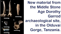
New material from the Middle Stone Age Dorothy Garrod archaeological site, in the Olduvai Gorge, Tanzania.

The Olduvai Gorge in Tanzania is famous for its archaeological sites, notably those associated with early Hominins and the appearance of the genus Homo. However, the area also produces later material, and in particular is home to a number of important Middle Stone Age sites, providing incite into a key stage in the development of Modern Humans. The Middle Stone Age material of the Olduvai Gorge is found within the Ndutu Beds, a succession of tuffacious (volcanic ash), aeolian (wind-blown) and fluvial (river deposited) sediments. These beds can be divided into Upper and Lower units, and are overlain by the Naisiusiu Beds, which produce Later Stone Age material.

Various attempts have been made at dating the Ndutu Beds, none of which is considered definitive. In the 1970s, Richard Hay used amino-acid dating to estimate that the Lower Unit of the Ndutu Beds was laid down between 400 000 and 60 000 years ago, while the Upper Unit is between 60 000 and 32 000 years old. In 1993 Paul Manega used  single‑crystal laser fusion to estimate that the Lower Unit is between 450 000 and 210 000 years old, and that the bottom of the Naisiusiu Beds dates from 42 000 years ago, while a decade later a team led by Anne Skinner dated the start of the Naisiusiu Beds to 62 000 years ago using electron spin resonance.

Two sets of fragmentary Human remains have been recovered from the Ndutu Beds, a palate and maxillary arch considered robust by modern standards, and which was consequently assigned to Homo sp., was described by Mary Leaky in 1971, and  partial calvaria (top part of the skull) assigned to Homo sapiens was described by a team led by Whitney Rainer in 2017. Both of these specimens are derived from the Upper Member of the Ndutu Beds, but neither has been directly dated.

The palate and maxillary arch were found at a location called Dorothy Garrod, which is on the northern side of the Main Olduvai Gorge, 200 m to the west of the KK Fault and opposite the junction with the Side Gorge. Mary Leaky believed the material here was related to the Middle Stone Age material from the Ngaloba Beds at Laetoli, but was not able to date it more precisely. In 1990 Audax Mabulla revisited the area, but again was unable to date the location. In the 2010s a team led by Metin Eren gathered a series of Middle Stone Age stone tools from Dorothy Garrod, but were not able to produce a date for the site.

In a paper published in the journal Archaeological and Anthropological Sciences on 18 August 2022, a team led by José Manuel Maíllo‑Fernández of the Department of  Prehistory and Archaeology at the Universidad Nacional de Educación a Distancia, and the Institute of Evolution in Africa at Alcalá University, presents the results of excavations at Dorothy Garrod, carried out in February and July 2018 and February 2019.

The same team previously carried out excavations at  the Victoria Cabrera Site, 400 m to the southwest of Dorothy Garrod, revealing several layers containing Middle Stone Age tools and faunal remains, which they were able to date to between 86 000 and 75 000 years before the present. 

(A)–(C) Location of Dorothy Garrod Site (DGS) and Victoria Cabrera Site (VCS) in the Olduvai Gorge; (D) view of the Dorothy Garrod Site excavation. Maíllo‑Fernández et al. (2022).

All of the exposed sediments at Dorothy Garrod are attributed to the Upper Unit of the Ndutu Formation, and are assumed to be slightly older than the sediments at Victoria Caberera, based upon their stratigraphic context, but has not been dated more accurately than this.

Excavations were carried out to a depth of 3.5 m, exposing a series of layers identified as Levels 1-4. Level 4, at the base of the sequence, is a perfectly sorted and cemented sand layer interpreted as aeolian in origin. Level 3 is a well sorted but poorly cemented tuffaceous silt, also interpreted as aeolian in origin, which yielded a variety of Middle Stone Age material. Level 2 is a well sorted and cemented tuffaceous silt, again interpreted as aeolian in origin, which produced no archaeological material. Level 1 is a well sorted and cemented very fine sand, which again produced no archaeological material.

Stratigraphic section of the Dorothy Garrod Site. Maíllo‑Fernández et al. (2022).

The faunal remains recovered from Dorothy Garrod comprise 247 fragments of bone, 27 teeth and fragments of teeth, two Ostrich shell fragments, and four terrestrial Mollusc shell fragments. Two of the teeth could be identified as those of Equids (Horses, Asses, Zebras etc.), a mandible could be assigned to the Hippotragini (Grazing Antelopes), and four teeth to the Alcelaphini (Wildebeest, Hartebeest, Bonteboks etc.). None of the other tooth or bone fragments could be identified. The bones were generally poorly preserved, at least in part due to the presence of sediment concretions which had affected the surface of many bones. Fifty eight of the bones show evidence of burning, while two (both interpreted as the long bones of Ungulates) have notches cut into them; only one has a carnivore tooth mark.

Faunal remains from the Dorothy Garrod Site. (1) Femur of Ungulate of size 1b with fresh bone breakage; (2) fragment of a femur of an Ungulate of size 2 with generalised sediment concretions; (3) fragment of a vertebra with burning; (4) fragment of a long bone of size 2 with burning damage; (5) fragment of a vertebra of ungulate of size 3 with generalised sediment concretions. Maíllo‑Fernández et al. (2022).

A total of 1179 lithic items were recovered from Level 3 at Dorothy Garrod, 40 of which showed signs of reatouching. Of these tools 113 were excluded from the study due to subsequent alteration, the majority of these being made from phonolite. 

Only six pieces showed signs of rounding (i.e. shaping by being rolled in an aquatic environment), and in only one case was this severe, so hydraulic damage (which can sometimes break rocks in a way that can resemble early stone tools) can be ruled out as a cause of the lithic assemblage. 

The assemblage included 615 blanks (pieces of rock of suitable size and shape to make stone tools from) with pseudo‑retouching (damage which at first site resembled the actions of a toolmaker). The majority of these are likely to have been caused by trampling, but a few may have been caused by a knapping process, in which they were removed from a rock source.

The majority (79.9%) of the tools at Dorothy Garrod are made from Naibor quartzite, a metamophicly recrystalized sandstone which outcrops at Naibor Soit Hill, 2 km to the north of the Olduvai Gorge. Another 8.2% are made from phonolite, derived from the Engelosen Volcano, 7 km to the north, and 3.6% are made of a basalt derived from the Lemagrut Volcano, 10-12 km to the south. The remainder of the material appears to be locally sourced, including sandstone (6.1%), hyaline quartz (1.4%), chert (0.3%), quartzite (0.1%), and gneiss (0.1%).

Only 7% of the blanks were completely covered by a cortex (the natural surface of a rock caused by chemical weathering, which is removed during toolmaking), while 18% had a partial cortex surface; over 75% had no cortex at all on at least one side.

Of the 757 worked blanks found, 458 could not be associated with any toolmaking scheme, while the remainder were either single platform blanks, or prepared core blanks, either discoid or Levallois. There were no bipolar cores.

Discoidal knapping (removing chips to be used as tools from the surface of a rock by working around it in a circular pattern) was the most common toolmaking method, with 26 discoid cores found, and 222 blanks with chips removed in a discoid pattern. Chips had been removed both unifacially (all from one side) and bifacially (from both sides). The most commonly used rock for this was Naibor quartzite, but some basalt and local quartzite were also used. The knapping had been used to produce chordal flakes, pseudo Levallois points, square f lakes, and flakes wider than they are long.

Lithics from Dorothy Garrod. (1) Discoid core; (2)–(4) discoid flakes. All on Naibor quartzite. Maíllo‑Fernández et al. (2022).

Only 24 blanks and 1 core had been exploited using the Levallois technique; forming a striking platform at one end of a stone tool, then trimming the core's edges by flaking off pieces around the outline of the intended lithic flake, prior to separating the tool with a final blow, which creates a tool with a distinctive plano-convex profile, and leaves a core with a rounded 'tortoiseshell' pattern. The core and the majority of the blanks were made using the centripetal Levallois technique, which can be difficult to tell from the discoidal method, and possibly evolved from it, with the remainder using the preferential, unidirectional, and bidirectional variants of the technique. No Levallois points were found.

Single platform knapping had been used to make 38 flakes and a single core. These were again predominantly made of Naibor quartzite, with phonolite, basalt, and hyaline quartzite also used.

Other cores at the site appeared to have been worked using the polyhedric and/or oportunistic methods (which can be hard to tell apart. A single Kombewa flake (large flake made by striking a core from two different sites) was discovered.

The majority of the retouched items were denticulate tools, followed by retouched flakes, notches, and sidescrapers. Two large retouched items were found, a bifacial and a transversal sidescraper. Again, the majority of these were made from Naidor quartzite. 

Lithics from Dorothy Garrod. (1) Unipolar Levallois flake; (2) pseudo Levallois flake; (3) preferential Levallois flake; (4) discoid flake; (5) denticulate on ordinary flake; (6) sidescraper on ordinary flake; (7) Centripetal Levallois core; (8) Centripetal Levallois flake; (9) unifacial discoid core. Raw materials: (1), (2), and (8): basalt; (2)–(7) and (9): Naibor quartzite. Maíllo‑Fernández et al. (2022).

The combination of a plentiful lithic assemblage and faunal remains showing signs of Human modification make the Dorothy Garrod Site a regionally important Middle Stone Age locality. The precise age of this deposit is still unknown, but only an area of 28 m² has been excavated, so it is quite possible that datable material will be uncovered in the future. The material does not appear to be preferentially orientated or abraded, suggesting that it has not been moved significantly by post-depositional processes. 

None of the Mammal remains are well preserved, but the vast majority appear to represent Ungulates, and many show signs of modification, either by burning or breaking. Although burning of bones is common, no charcoal usable for dating was recovered. Evidence of modification of the bones by non-Human predators was almost absent.

The majority of the tools found were made for which a manufacturing technique could be identified were made using the discoidal or Levallois methods, with single platform and opportunistic knapping being much less common, and only a single bifacial tool was found, and Levallois points were completely absent. A small number of tools showed signs of retouching. The majority of the tools were made from Naibor quartzite, sourced from a hill 2 km to the north.

The absence of datable material makes it hard to assess the age of the Dorothy Garrod Site, but it may be contemporary with the Kisele industry, found at Mumba Cave near Lake Eyasi and the Nasera Rockshelter in the Ngorongoro Conservation Area, and the Loiyangalanian industry from Loiyangalani in the Serengeti National Park. However, such comparisons are difficult to make; discoidal manufacture is common at almost all Middle Stone Age sites in East Africa, as is the use of materials obtained fairly locally, and while the tool-making appears closest to the Kisele and Loiyangalanian industries, both unifacial and bifacial points are common components of the Kisele industry, but absent at Dorothy Garrod, and bipolar knapping also absent at Dorothy Garrod, is a common feature at Loiyangalani. The low level of retouching at Dorothy Garrod may reflect the material being used; quartzite lends itself to this far less well than chert (rare at Dorothy Garrod) or obsidian (absent altogether).

Although Maíllo‑Fernández et al. have expanded on previous work at Dorothy Garrod, they consider the site still has much more to reveal. The site records a Middle Stone Age technology along with faunal remains almost certainly left by the tool-makers. The site has not been dated, but based upon comparison to tools from other sites it is probably dates from Marine Isotope Stage 5-Marine Isotope Stage 4 (i.e. is between 130 000 and 71 000 years old).

Further excavations at Dorothy Garrod have the potential to resolve the dating of the site, as well as shedding light upon Middle Stone Age patterns of settlement, and how these people interacted with their environment.

See also...

Follow Sciency Thoughts on Facebook.

Follow Sciency Thoughts on Twitter


Tuesday, 28 December 2021

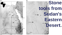
Stone tools from Sudan's Eastern Desert.

The key areas for the migration of Hominins from Africa into Eurasian appear to have been the Eastern Sahara Desert of Egypt and Sudan and the Arabian Peninsula. Two distinct groups of Hominins appear to have used this route, Homo erectus/ergaster in the Middle Pleistocene, and Homo sapiens in the Late Pleistocene. This area appears to have undergone a considerable cultural shift around the boundary between Marine Isotope Stages 7 and 6, i.e. about 191 000 years ago, with material associate with the Early Stone Age Acheulean Tradition, which is associated with Homo erectus/ergaster, and which had dominated Africa, Europe, and Asia for about 1.5 million years, being replaced by material associated with the Sangoan Complex, which is considered to be a Early Stone Age/Middle Stone Age transitional technology that might be associated with the arrival of Early Modern Humans in the area (although the earliest known Early Modern Human remains are associated with the more advanced Levallois technology).

The Acheulean technology is largely associated with large cutting tools, such as handaxes, cleavers, picks, and choppers, worked symmetrically by removing flakes from each side, but with little use of the smaller flakes produced. The Sangoan is marked by the production smaller bifaced stone tools, with more retouching to produce finer edges, as well as a greater use of bone and antler tools. The Levallois Technology involved preparing a stone core, then chipping away flakes progressively to form a pattern resembling a Tortoise shell, with the primary objective apparently being to produce a series of small, sharp chips, which were themselves used as tools.

Sangoan assemblages are found over a wide area of Africa, with several sites in Sudan having produced them, notably Sai-8-B-11, Khor Abu Anga, and al-Jamrab. A number of site associated with the Levallois technology have also been found in northeast Africa, with the best known being Dakhleh Oasis  and Kharga Oasis Locus IV in the Egyptian Western Desert, both of which have been dated to about 220 000 years ago, and Bir Sahara East and Bir Tarfawi, also in Egypt, which have been dated to younger than 130 000 years ago.

In a paper published in the Journal of Field Archaeology on 11 November 2021, Grzegorz Michalec of the University of Wrocław, Marzena Cendrowska, also of the University of Wrocław, and of the Archeolodzy Foundation, Eric Andrieux of the University of London and Durham University, Simon Armitage, also of the University of London, and of the University of Bergen, Maciej Ehlert, again of the niversity of Wrocław, and of the Archeolodzy Foundation, Ju Yong Kim of the Korea Institute of Geoscience and Mineral Resources, Young Kwan Sohn of the Gyeongsang National University, Joanna Krupa-Kurzynowska of the Wroclaw University of Science and Technology, Piotr Moska of the Silesian University of Technology, Marcin Szmit of the Gdańsk Archaeological Museum, and Mirosław Masojć, once again of the University of Wrocław, present the results of an excavation carried out in 2019 at a site called EDAR 135 in the in the Atbara River region of Sudan's Eastern Desert. 

Acheulean remains were first recorded in the in the Atbara River region at Khor Hudi and Khashm el Girba by Anthony John Arkell in the 1940s, with subsequent exploration around Khashm el Girba by Waldemar Chmielewski in 1967 uncovering a further 26 sites yielding Acheulean and Levallois artifacts. In 2005-2008 a series of expeditions led by Ernesto Abbate revealed uncovered a 50 m thick sequence along the mid-Atbara River between Khashm el Girba and Halfa al Jadida, which produced Pleistocene faunal remains and Acheulean handaxes dated to Marine Isotope Stage 7 (243 000-191 000 years ago) and Levallois assemblages dated to between 126 000  and 92 200 years ago.

 
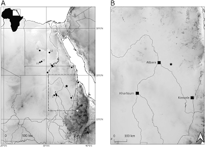
Location of Acheulean and Levallois sites in Sudan and Egypt (EDAR 135 marked with a star). (1) Khashm el Girba; (2) Khor Abu Anga; (3) Al-Jamrab; (4) Khor Shambat; (5) Hayna and Tagrada; (6) Sai Island 8-B-11; (7) Gebel Karaiweb; (8) Wadi Halfa; (9) Arkin 8; (10) Bir Sahara; (11) Bir Tarfawi; (12) Kharga Oasis; (13) Dakhla Oasis. Michalec et al. (2021).

The Eastern Desert Atbara River Project was a collaboration between the Institute of Archaeology at the University of Wrocław, the Faculty of Archaeology & Tourism at Al Neelain University, the Korea Institute of Geoscience and Mineral Resources, and the Research Institute of Natural Science of the Gyeonsang National University, which aimed to identify new Middle and Upper Pleistocene archaeological sites in a stretch of the Sudanese Eastern Desert about 70 km to the east of Atbara city, in a series of expeditions between 2016 and 2019.

The project took advantage of recent excavations carried out by gold prospectors. Gold has been excavated in Sudan since ancient times, with a recent gold rush beginning in 2008. This has been somewhat of a mixed blessing for archaeologists working in the region, on the one hand uncovering a number of new, previously unknown, archaeological deposits, but on the other damaging or destroying a number of sites completely, both new and previously known, including some which were specifically targeted for their gold artefacts.

 
EDAR 135 site. (A) Aerial photography of mining shaft complex; EDAR 135 marked with black arrow; (B) aerial photography of the EDAR 135 site; (C) eastern profile of mining shaft with marked (red dots) places of Optically Stimulated Luminescence dating samples S4 and S5 sampling places; (D) northern profile; (E) northern profile before upper level excavations; (F) removing sterile sediments above the lower horizon; and, (G) excavating lower horizon (Acheulean). Michalec et al. (2021).

The EDAR 135 site was discovered in 2017, when lithic items were discovered in the wall of a 5 m deep mining shaft. The site was cleaned up, a geological assessment made, and a series of samples collected for Optically Stimulated Luminescence dating. In 2018 the team returned to the site, to carry out further mapping and sampling. Finally, in 2019, a 5 m² trench was excavated northward of the mining shaft, by removing the overburden with hoes and pickaxes, then excavating the archaeological layers with brushes, geological picks, and small trowels, and finally sieving the excavated sediment through a 5 mm mesh.

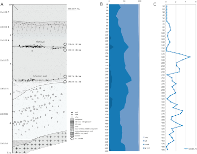
The excavated section is 5 m deep, with a base of weathered rhyolite (high silica volcanic rock), which is overlain by a sequence of sand/silt sediments with interbedded gravel and rock fragment horizons. The oldest sediments were dated to more than 391 000 years old. Artefacts were recovered from two gravel horizons, the lower dated to between 194 800 and 144 700 years ago, the upper dated to between 125 300 and 116 400 years ago.

 
Northern profile and chronology of EDAR 135. (A) Stratigraphy and two cultural horizons with Optically Stimulated Luminescence dating results; (B) results of granulometry analysis; and, (C) calcium carbonate content. Michalec et al. (2021).

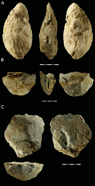
The lower tool-producing layer at EDAR 135 produced three Acheulean large cutting tools; a quartz handaxe, a partial rhyolite handaxe, which had apparently been crushed by gold mining machinery, and a rhyolite chopper.

 
Large Cutting Tools from EDAR 135: (A) handaxe, quartz; (B) basal fragment of a handaxe, rhyolite; and, (C) chopper made from a rhyolite cobble. Michalec et al. (2021).

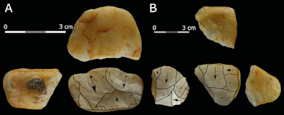
In addition to the large cutting tools, seven cores were recovered from the lower tool-bearing layer. Five of these were small cores made from quartz, all of which were heavily reduced by the removal of multiple flakes. These show signs of a number of different preparation methods being used.

 
Cores made from quartz pebbles: (A) bipolar and (B) flake core with changed orientation. Michalec (2021).

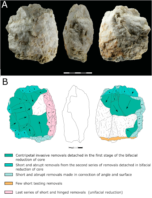
The first of the larger cores is a discoidal piece of quartz, that has a non-hierarchized structure, and shows no traces of predetermination. The maker appears to have focused on bifacial, centripetal removals, then corrected the flaking angle with a series of short removals to prepare the striking platform, and finally aimed at unifacial reduction with the natural surface of the less transformed side used as the striking platform.

 
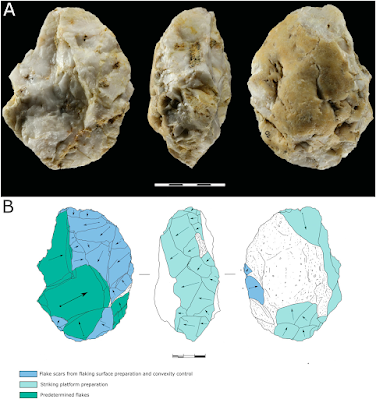
(A) Levallois core (quartz) from EDAR 135, lower horizon and (B) graphic presentation of scar pattern analysis results. Michalec et al. (2021)

The second larger core is also quartz, a prepared centripetal flake core, showing hierarchisation of structure and a high degree of preparation. The primary surface is completely decorticated by centripetal removals, while the secondary surface was used as the striking platform. This tool appears to have gone through three stages of development, firstly preparing the flaking surface by unifacial removals, with a 75–90° flaking angle, then the preparation and control of the main flaking surface, and finally the removal of invasive and long flakes.

 
(A) Discoidal core (quartz) from EDAR 135, lower horizon and (B) graphic presentation of scar pattern analysis results. Michalec et al. (2021).

The most abundant artefacts at EDAR 135 are debitage flakes and chips (pieces removed from a larger core, which may-or-may not be intended for use as tools in themselves) and waste. This comprised 549 chips, 119 flakes, and 36 other debris items. The overwhelming majority of this material is quartz, with only 7 flakes and 11 chips made of rhyolite. In addition, there were 23 retouched tools, formed by the modification of chips after they were removed from a core to form six denticulates, four sidescrapers, two flakes with simple retouch, three notches, three perforators, two endscrapers, two combined tools with mixed retouch, and one Levallois flake.

 
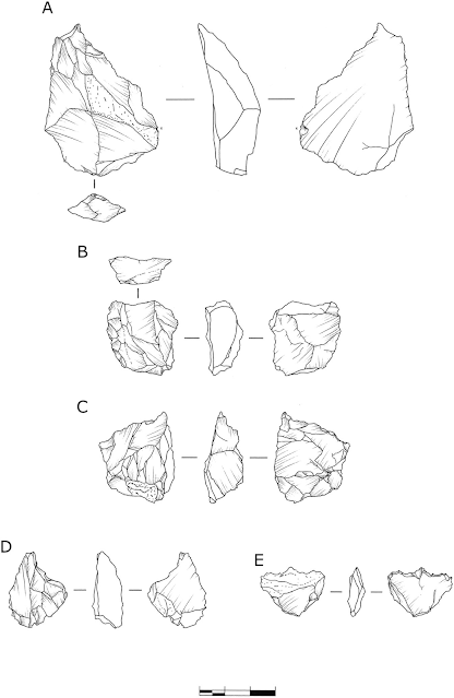
Retouched tools: (A)–(B) sidescrapers and (C)–(E) perforators. (A) Rhyolite and (B)–(E) quartz. Michalec et al. (2021).

The tools in the lower tool-bearing layer at EDAR 135 follow two basic patterns of construction, the preparation of large cutting tools such as axes and choppers, fairly typical of the Acheulean technology, and the preparation of smaller tools by chipping away from a core, sometimes with subsequent modification. This latter methodology is generally associated with the Levallois technology, but Michalec et al. feel they do not show the level of predetermination associated with true Levallois items. Rather, they point to similarities with tools made in the same way found at sites in Africa and the Near East alongside typical Acheulean tools, at sites such as Maunagidze (Zimbabwe), Victoria West (South Africa), and Jaljulia and Revadim (both Israel), as well as several sites in Egypt and Sudan, as evidence the site can be linked to a Late Acheulean culture, which produced some Levallois-type tools.

The dating of this Late Acheulean assemblage is itself somewhat complex. At Dakhla and Kharga Oasis in Egypt the latest Acheulean material has been dated to 400 000-300 000 years ago, while at Khashm el Girba in northeastern Sudan a Late Acheulean assemblage has been dated to Marine Isotope Stage 7 (i.e. 243 000-191 000 years ago), and an assemblage at ai Island 8-B-11 in northern Sudan has not been directly dated, but is overlain directly by a horizon dated to 223 000 years ago.

The oldest Middle Stone age assemblages appear in Afirca at Jebel Irhoud in Morocco with an age of 315 000 years, the Olorgesailie Basin, dated to 305 000 years ago, and in the Gademotta Formation of Ethiopia, which is at least 275 000 years old. Middle Stone Age assemblages are generally thought to replace Old Stone Age assemblages in a linear fashion, with the production of Old Stone Age tools has previously been thought to have stopped in Eastern Saharan Africa by about 200 000 years ago, but a later date of 175 000-160 000 has more recently been suggested. The lower tool-bearing horizon at EDAR 135 is dated to between 194 800 and 144 700 years ago, which is in keeping with this newer dating. Michalec et al. suggest the simple picture of one technology arriving in an area and immediately replacing another is probably wrong, and that a cultural mosaic, with different peoples in the same area using different technologies over long time intervals is probably more accurate.

See also...


Follow Sciency Thoughts on Facebook.

Follow Sciency Thoughts on Twitter.