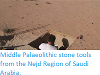
The key areas for the migration of Hominins from Africa into Eurasian appear to have been the Eastern Sahara Desert of Egypt and Sudan and the Arabian Peninsula. Two distinct groups of Hominins appear to have used this route, Homo erectus/ergaster in the Middle Pleistocene, and Homo sapiens in the Late Pleistocene. This area appears to have undergone a considerable cultural shift around the boundary between Marine Isotope Stages 7 and 6, i.e. about 191 000 years ago, with material associate with the Early Stone Age Acheulean Tradition, which is associated with Homo erectus/ergaster, and which had dominated Africa, Europe, and Asia for about 1.5 million years, being replaced by material associated with the Sangoan Complex, which is considered to be a Early Stone Age/Middle Stone Age transitional technology that might be associated with the arrival of Early Modern Humans in the area (although the earliest known Early Modern Human remains are associated with the more advanced Levallois technology).
The Acheulean technology is largely associated with large cutting tools, such as handaxes, cleavers, picks, and choppers, worked symmetrically by removing flakes from each side, but with little use of the smaller flakes produced. The Sangoan is marked by the production smaller bifaced stone tools, with more retouching to produce finer edges, as well as a greater use of bone and antler tools. The Levallois Technology involved preparing a stone core, then chipping away flakes progressively to form a pattern resembling a Tortoise shell, with the primary objective apparently being to produce a series of small, sharp chips, which were themselves used as tools.
Sangoan assemblages are found over a wide area of Africa, with several sites in Sudan having produced them, notably Sai-8-B-11, Khor Abu Anga, and al-Jamrab. A number of site associated with the Levallois technology have also been found in northeast Africa, with the best known being Dakhleh Oasis and Kharga Oasis Locus IV in the Egyptian Western Desert, both of which have been dated to about 220 000 years ago, and Bir Sahara East and Bir Tarfawi, also in Egypt, which have been dated to younger than 130 000 years ago.
In a paper published in the Journal of Field Archaeology on 11 November 2021, Grzegorz Michalec of the University of Wrocław, Marzena Cendrowska, also of the University of Wrocław, and of the Archeolodzy Foundation, Eric Andrieux of the University of London and Durham University, Simon Armitage, also of the University of London, and of the University of Bergen, Maciej Ehlert, again of the niversity of Wrocław, and of the Archeolodzy Foundation, Ju Yong Kim of the Korea Institute of Geoscience and Mineral Resources, Young Kwan Sohn of the Gyeongsang National University, Joanna Krupa-Kurzynowska of the Wroclaw University of Science and Technology, Piotr Moska of the Silesian University of Technology, Marcin Szmit of the Gdańsk Archaeological Museum, and Mirosław Masojć, once again of the University of Wrocław, present the results of an excavation carried out in 2019 at a site called EDAR 135 in the in the Atbara River region of Sudan's Eastern Desert.
Acheulean remains were first recorded in the in the Atbara River region at Khor Hudi and Khashm el Girba by Anthony John Arkell in the 1940s, with subsequent exploration around Khashm el Girba by Waldemar Chmielewski in 1967 uncovering a further 26 sites yielding Acheulean and Levallois artifacts. In 2005-2008 a series of expeditions led by Ernesto Abbate revealed uncovered a 50 m thick sequence along the mid-Atbara River between Khashm el Girba and Halfa al Jadida, which produced Pleistocene faunal remains and Acheulean handaxes dated to Marine Isotope Stage 7 (243 000-191 000 years ago) and Levallois assemblages dated to between 126 000 and 92 200 years ago.
The Eastern Desert Atbara River Project was a collaboration between the Institute of Archaeology at the University of Wrocław, the Faculty of Archaeology & Tourism at Al Neelain University, the Korea Institute of Geoscience and Mineral Resources, and the Research Institute of Natural Science of the Gyeonsang National University, which aimed to identify new Middle and Upper Pleistocene archaeological sites in a stretch of the Sudanese Eastern Desert about 70 km to the east of Atbara city, in a series of expeditions between 2016 and 2019.
The project took advantage of recent excavations carried out by gold prospectors. Gold has been excavated in Sudan since ancient times, with a recent gold rush beginning in 2008. This has been somewhat of a mixed blessing for archaeologists working in the region, on the one hand uncovering a number of new, previously unknown, archaeological deposits, but on the other damaging or destroying a number of sites completely, both new and previously known, including some which were specifically targeted for their gold artefacts.
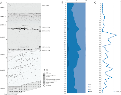
The EDAR 135 site was discovered in 2017, when lithic items were discovered in the wall of a 5 m deep mining shaft. The site was cleaned up, a geological assessment made, and a series of samples collected for Optically Stimulated Luminescence dating. In 2018 the team returned to the site, to carry out further mapping and sampling. Finally, in 2019, a 5 m² trench was excavated northward of the mining shaft, by removing the overburden with hoes and pickaxes, then excavating the archaeological layers with brushes, geological picks, and small trowels, and finally sieving the excavated sediment through a 5 mm mesh.
The excavated section is 5 m deep, with a base of weathered rhyolite (high silica volcanic rock), which is overlain by a sequence of sand/silt sediments with interbedded gravel and rock fragment horizons. The oldest sediments were dated to more than 391 000 years old. Artefacts were recovered from two gravel horizons, the lower dated to between 194 800 and 144 700 years ago, the upper dated to between 125 300 and 116 400 years ago.
The lower tool-producing layer at EDAR 135 produced three Acheulean large cutting tools; a quartz handaxe, a partial rhyolite handaxe, which had apparently been crushed by gold mining machinery, and a rhyolite chopper.
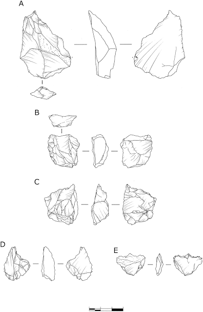
In addition to the large cutting tools, seven cores were recovered from the lower tool-bearing layer. Five of these were small cores made from quartz, all of which were heavily reduced by the removal of multiple flakes. These show signs of a number of different preparation methods being used.
The first of the larger cores is a discoidal piece of quartz, that has a non-hierarchized structure, and shows no traces of predetermination. The maker appears to have focused on bifacial, centripetal removals, then corrected the flaking angle with a series of short removals to prepare the striking platform, and finally aimed at unifacial reduction with the natural surface of the less transformed side used as the striking platform.
The second larger core is also quartz, a prepared centripetal flake core, showing hierarchisation of structure and a high degree of preparation. The primary surface is completely decorticated by centripetal removals, while the secondary surface was used as the striking platform. This tool appears to have gone through three stages of development, firstly preparing the flaking surface by unifacial removals, with a 75–90° flaking angle, then the preparation and control of the main flaking surface, and finally the removal of invasive and long flakes.
The most abundant artefacts at EDAR 135 are debitage flakes and chips (pieces removed from a larger core, which may-or-may not be intended for use as tools in themselves) and waste. This comprised 549 chips, 119 flakes, and 36 other debris items. The overwhelming majority of this material is quartz, with only 7 flakes and 11 chips made of rhyolite. In addition, there were 23 retouched tools, formed by the modification of chips after they were removed from a core to form six denticulates, four sidescrapers, two flakes with simple retouch, three notches, three perforators, two endscrapers, two combined tools with mixed retouch, and one Levallois flake.
The tools in the lower tool-bearing layer at EDAR 135 follow two basic patterns of construction, the preparation of large cutting tools such as axes and choppers, fairly typical of the Acheulean technology, and the preparation of smaller tools by chipping away from a core, sometimes with subsequent modification. This latter methodology is generally associated with the Levallois technology, but Michalec et al. feel they do not show the level of predetermination associated with true Levallois items. Rather, they point to similarities with tools made in the same way found at sites in Africa and the Near East alongside typical Acheulean tools, at sites such as Maunagidze (Zimbabwe), Victoria West (South Africa), and Jaljulia and Revadim (both Israel), as well as several sites in Egypt and Sudan, as evidence the site can be linked to a Late Acheulean culture, which produced some Levallois-type tools.
The dating of this Late Acheulean assemblage is itself somewhat complex. At Dakhla and Kharga Oasis in Egypt the latest Acheulean material has been dated to 400 000-300 000 years ago, while at Khashm el Girba in northeastern Sudan a Late Acheulean assemblage has been dated to Marine Isotope Stage 7 (i.e. 243 000-191 000 years ago), and an assemblage at ai Island 8-B-11 in northern Sudan has not been directly dated, but is overlain directly by a horizon dated to 223 000 years ago.
The oldest Middle Stone age assemblages appear in Afirca at Jebel Irhoud in Morocco with an age of 315 000 years, the Olorgesailie Basin, dated to 305 000 years ago, and in the Gademotta Formation of Ethiopia, which is at least 275 000 years old. Middle Stone Age assemblages are generally thought to replace Old Stone Age assemblages in a linear fashion, with the production of Old Stone Age tools has previously been thought to have stopped in Eastern Saharan Africa by about 200 000 years ago, but a later date of 175 000-160 000 has more recently been suggested. The lower tool-bearing horizon at EDAR 135 is dated to between 194 800 and 144 700 years ago, which is in keeping with this newer dating. Michalec et al. suggest the simple picture of one technology arriving in an area and immediately replacing another is probably wrong, and that a cultural mosaic, with different peoples in the same area using different technologies over long time intervals is probably more accurate.
See also...


Follow Sciency Thoughts on Facebook.
Follow Sciency Thoughts on Twitter.


