Thursday 31 July 2014

At least 41 dead following landslide near Pune in Maharashtra.

At least 41 people have died and between 120 and 350 are missing after a landslide destroyed the village of Malin, about 80 km north of Pune in Maharashtra State, on the morning of Wednesday 30 July 2014. The incident occurred after about two days of heavy rains, and continuing rain is said to be severely hampering rescue attempts. Landslides are a common problem after severe weather events, as excess pore water pressure can overcome cohesion in soil and sediments, allowing them to flow like liquids. Approximately 90% of all landslides are caused by heavy rainfall.

The scene of the Malin landslide on Wednesday 30 July 2014. AP/Press Trust of India.

July is peak monsoon season in Pune District, with an average monthly rainfall of 187.2 mm, out of an annual average of 721.7. This year, however, rainfall in the area has been exceptionally high with 83 mm falling in the 24 fours prior to the landslide. The situation is thought to have been made worse by extensive deforestation in the area, with trees being harvested in an unregulated way for timber for use in the construction and mining industries. Tree roots can help to hold soft sediments together on slopes, and deforestation is often associated with landslides.

Rescue workers at the scene of the Malin landslide on Wednesday 30 July 2014. Hindustan Times.

The approximate location of the 30 July 2014 Malin landslide. Google Maps.

See also...

 Five dead after landslide at Antop Hill, Mumbai.

Five people have died following a landslide in the Antop Hill area of central Mumbai on Wednesday 10 July 2013. The incident happened...

 Man killed in Kerala Landslide.

A man was killed when a landslide struck a the Rocha Hotel in the resort town of Munnar in the Idukki District of Kerala State, India at around 3.30 am on Tuesday 25 June local time (10.00 pm on Monday 24 June, GMT). He has been named as Zakariahkutty, a chef in his...


 Three workers killed in landslide at Mumbai quarry.

Three workers have been killed, and a further two injured, in a landslide at a quarry in Navi Mumbai (a satelite town of Mumbai)...


Follow Sciency Thoughts on Facebook.

A new species of Anthazoan Coral from the Abrolhos Archipelago and Royal Charlotte Bank, Brazil.

The Abrolhos Bank is an area of the Brazilian continental shelf to the south of Bahia State, noted for its large and rich coral reef fauna and unique geochemical nature, with high levels of siliclastic material (sand, quartz gravel etc.) being deposited in the area by the Brazil Current, which flows southward from the coast. The area includes the Abrolhos Archipelago, which is Brazil’s oldest marine reserve.

In a paper published in the journal Zootaxa on 4 July 2014, Sérgio Stampar of the Departamento de Ciências Biológicas at the Universidade Estadual Paulista and the Departamento de Zoologia at the Universidade de São Paulo, and André Morandini and Fábio Lang da Silveira, also of the Departamento de Zoologia at the Universidade de São Paulo, describe a new species of Anthazoan Coral from Abrolhos Archipelago and Royal Charlotte Bank on the Abrolhos Bank.

The new species is placed in the genus Pachycerianthus, and given the specific name schlenzae, in honour of Erika Schlenz formerly of the Departamento de Zoologia at the Universidade de São Paulo, and a well-known expert on Corals. Pachycerianthus schlenzae is a solitary Coral reaching about 15 cm in height, with 60-85 marginal tentacles reaching about 12 cm in length plus 60-80 labial tentacles, reaching about 4 cm. The tentacles are brown or purple with white spots.

Pachycerianthus schlenzae, live specimens. (A) From Guarapari in Espirito Santos State. (B) From Camamu Bay in Bahia State. Stampar et al. (2014).

See also…


Zoanthids are unusual Corals with similarities to both the reef-forming calcareous skeleton excreting Scleractinian Corals and the larger, free living Sea Anemones. Most species are colonial, with...


Scleractinian Corals first appeared in the fossil record in the Middle Triassic; they are distinct from, but  believed to be related to the Rugose and Tabulate Corals of the Palaeozoic. All modern Corals...


Corals on Australia's Great Barrier Reef, as in other parts of the world, are known to be in trouble, with declining Coral coverage, diebacks, bleaching events and replacement of Corals by Macroalgae (Seaweed) on much of the reef. Unfortunately, recording of Coral...


Follow Sciency Thoughts on Facebook.

Asteroid 2014 OD4 passes the Earth.

Asteroid 2014 OD4 passed by the Earth at a distance of 12 250 000 km (32.58 times the average distance between the Earth and the Moon, or 8.4% of the average distance between the Earth and the Sun), slightly before 12.45 pm GMT on Sunday 27 July 2014. There was no danger of the asteroid hitting us, though had it done so it would have presented only a moderate threat. 2014 OD4 has an estimated equivalent diameter of 25-78 m (i.e. it is estimated that a spherical object with the same volume would be 25-78 m in diameter), and an object of this size would be expected to break up in the atmosphere between 20 and 1.5 km above the ground, with only fragmentary material reaching the Earth's surface, although being directly beneath an object towards the upper end of this range would probably be quite unpleasant, as it would be expected to explode with the energy equivalent to about 20 megatons of TNT (over a thousand times as powerful as the Hiroshima bomb).

The calculated orbit of 2014 OD4. JPL Small Body Database Browser.

2014 OD4 was discovered on 25 July 2014 (two days before its closest approach to the Earth) by the University of Hawaii's PANSTARRS telescope on Mount Haleakala on Maui. The designation 2014 OD4 implies that it was the 104th asteroid (asteroid D4) discovered in the second half of July 2014 (period 2014 O).

While 2014 OD4 occasionally comes near to the Earth, it does not actually cross our orbital path. It has an elliptical 529 day orbit, at an angle of 18.4° to the plane of the Solar System, that takes it from 1.08 AU from the Sun (1.08 times the average distance at which the Earth orbits the Sun), slightly outside our orbit, to 1.48 AU from the Sun, (1.48 times the distance at which the Earth orbits the Sun, slightly less than the average distance at which the planet Mars orbits the Sun). As a Near Earth Object that remains strictly outside the orbit of the Earth it is classed as an Amor Family Asteroid. This means that close encounters with the Earth do occasionally occur, with the next predicted for July 2192.

See also...


Asteroid 2014 MG55 passed by the Earth at a distance of about 10 080 000 km (26.22 times the average distance between the Earth and the Moon, or 6.7% of the average distance between the Earth and...


 Asteroid 2014 OP2 passes the Earth.

Asteroid 2014 OP2 passed by the Earth at a distance of 199 700 km (0.52 times the average distance between the Earth and the Moon), at about 8.35 am GMT on Thursday 24 July 2014. There was no...


 Asteroid 2014 MJ55 passes the Earth.

Asteroid 2014 MJ55 passed by the Earth at a distance of about 11 080 000 km (28.83 times the average distance between the Earth and the Moon, or 7.4% of the average distance between the Earth and...


Follow Sciency Thoughts on Facebook.

Tuesday 29 July 2014

Magnitude 1.4 Earthquake on the Isle of Mull.

The British Geological Survey recorded a Magnitude 1.4 Earthquake at a depth of 7 km beneath the northwest Isle of Mull, off the west coast of Scotland, slightly after 2.10 am British Summertime (slightly after 1.10 am GMT), on Monday 28 July 2014. There is no danger of any damage or injuries from a quake this size, but it may have been felt locally.

The approximate location of the 28 July 2014 Isle of Mull Earthquake. Google Maps.

Earthquakes become more common as you travel north and west in Great Britain, with the west coast of Scotland being the most quake-prone part of the island and the northwest of Wales being more prone  to quakes than the rest of Wales or most of England.

The precise cause of Earthquakes in the UK can be hard to determine; the country is not close to any obvious single cause of such activity such as a plate margin, but is subject to tectonic pressures from several different sources, with most quakes probably being the result of the interplay between these forces.

Britain is being pushed to the east by the expansion of the Atlantic Ocean and to the north by the impact of Africa into Europe from the south. It is also affected by lesser areas of tectonic spreading beneath the North Sea, Rhine Valley and Bay of Biscay. Finally the country is subject to glacial rebound; until about 10 000 years ago much of the north of the country was covered by a thick layer of glacial ice (this is believed to have been thickest on the west coast of Scotland), pushing the rocks of the British lithosphere down into the underlying mantle. This ice is now gone, and the rocks are springing (slowly) back into their original position, causing the occasional Earthquake in the process. 

(Top) Simplified diagram showing principle of glacial rebound. Wikipedia. (Bottom) Map showing the rate of glacial rebound in various parts of the UK. Note that some parts of England and Wales show negative values, these areas are being pushed down slightly by uplift in Scotland, as the entire landmass is quite rigid and acts a bit like a see-saw. Climate North East.

Witness accounts of Earthquakes can help geologists to understand these events, and the structures that cause them. If you felt this quake, or were in the area but did not (which is also useful information) then you can report it to the British Geological Survey here.

See also...


The British Geological Survey recorded a Magnitude 2.9 Earthquake at a depth of 5 km roughly 10 km to the west of Fort William in Highland County, Scotland, slightly after 7.35 pm British Summertime (slightly after 6.35 pm GMT) on Thursday 3 July 2014. This is a large quake for Scotland, but not dangerous and there are...


The British Geological Survey recored a Magnitude 1.3 Earthquake at a depth of 7 km on the Ardnamurchan Peninsula in the...


 Magnitude 1.0 Earthquake off the Isle of Jura.

The British Geological Survey recorded a Magnitude 1.0 Earthquake at a depth of 2 km, about 5 km off the west coast of the Isle of Jura...


Follow Sciency Thoughts on Facebook.

Families evacuated after Trinidad oil leak.

Several families have been forced to evacuate their homes after an oil well in Penal on southwest Trinidad began leaking at about 11 pm local time on Saturday 26 July 2014. Resident in the area have described being woken by a loud noise that sounded like and explosion, then seeing oil and gas spraying about 12 m into the air and raining down on rooftops and gardens, a situation which persisted for at several hours before operators Petrotrin were able to shut it off. A clean-up operation in the village went on for much of the following day.

Workers clearing up after an oil spill in Penal, Trinidad, on Sunday 27 July 2014. Dave Persad/Trinidad Express.

The Trinidad Oilfields Workers’ Trade Union (OWTU) has called for an investigation into management practices at Petrotrin following an series of similar incidents. Six workers were fired from the company following a leak in December, but the union claims the problems are caused by a systematic failure of management rather than the fault of ordinary workers.

The approximate location of the 26 July 2014 Trinidad oil leak. Google Maps.

See also...


Beaches in South Trinidad were closed by authorities after being covered by a thick layer of crude oil on 18 December 2013. Local fishermen have also been prevented from putting to sea by the event, putting livelihoods at risk, and residents have complained of nausea...


An oil and gas rig 95 km off the coast off Louisiana which has been burning for a day has begun to collapse into the Gulf of Mexico. The Walter Oil & Gas owned Hercules 265 jack-up rig (an oil rig that...


Two workers are feared dead after an explosion on an oil rig in the Gulf of Mexico on Friday 16 November 2012. The men, described...


Follow Sciency Thoughts on Facebook.

Two new species of Chalinid Dermosponge from Western Australia.

Chalinid Dermosponges are among the hardest Sponges to classify taxonomically due to their simple anatomies and variable morphologies. They are encrusting Sponges with skeletons made up of individual spicules which support their structure, but are not helpful taxonomically. Species are often distinctively coloured, but this is not visible in preserved specimens, making comparison to museum specimens extremely difficult. Chalinid Dermosponges are found globally and at all depths, but are most abundant and diverse in shallow subtidal waters (i.e. just below the low-tide level).

In a paper published in the journal Zootaxa on 9 July 2014, Jane Fromont of the Aquatic Zoology Department at the Western Australian Museum and David Abdo of the Marine Ecology and Monitoring Section of the Department of Fisheries of the Government of Western Australia describe two new species of Chalinid Dermosponge from temperate coastal waters off the coast of Western Australia, both of which are placed in the genus Haliclona.

The first new species is named Haliclona djeedara, which means 'brown' in the Nyoongar language, spoken by the indigenous people of south Western Australia. Haliclona djeedara is an erect, lobate, encrusting Sponge, light brown or beige in colour. It is firm, but compressible with a springy texture and large internal canals. It was found living on limestone reefs at depths of 3-30 m, in temperate waters south of 30˚ south, from Jurien Bay in the north to Bremer Bay in the south. It was observed giving birth to cylindrical parenchymellae larvae (planktonic Sponge larvae consisting of clumps of ciliated cells) in February, which is summer in Western Australia. The individual Sponges are gonochoric (sexed, can be male or female).

Underwater image of Haliclona djeedara. David Abdo in Fromont & Abdo (2014).

The second new species is named Haliclona durdong, meaning 'green' in the Nyoongar language. Haliclona durdong is an erect or massive Dermosponge with a smooth, velvety surface. It is compressible and easily damaged. It was found living on limestone reefs at depths of 3-30 m, in temperate waters south of 30˚ south, from Jurien Bay in the north to Bremer Bay in the south. It gives birth to to cylindrical parenchymellae larvae in the summer; individuals can apparently be gonochoric or hermaphroditic. 

Underwater image of Haliclona durdong. David Abdo in Fromont & Abdo (2014).

See also…


Theonellid Sponges are predominantly deepwater Sponges found across the globe, with a rigid skeleton made up of interlocking silica spicules. They are noted for the production of an array of unusual...


Unlike most Sponges (Porifera), which feed by filter feeding water pumped through their bodies, Carnivorous Sponges (Cladorhizidae) feed by capturing Crustaceans and other small animals on hooked spicules on filaments, then digesting them externally.  The group are predominantly found in deep water, where carnivory...


 A hypercalcified Chaetetid Demosponge from the Late Carboniferous of northwest Spain.

Sponges (Porifera) are considered to be the most primitive form of animals. They lack differentiated cells, and can reform if...


Follow Sciency Thoughts on Facebook.

The larvae of an Apochrysinid Green Lacewing.


All Insects undergo a set number of moults in their lifetimes, with the phases between these moults known as ‘instars’. Many Insects undergo a dramatic metamorphosis with their final moult, producing an adult instar that bears little resemblance to the larval instars. This can make understanding the life-cycles of Insects difficult, since the larvae often lead very different lifestyles to the adults and may not be readily identifiable. The Apochrysinae are an ancient group of Green Lacewings (Chrysopidae), with  an abundent fossil record but only 25 known living species divided into six genera, of these only the third larval instar of a single Japanese species (Apochrysa matsumurae) has ever been described.

In a paper published in the journal Zootaxa on 10 July 2014, Catherine Tauber of the Department of Entomology at Cornell University and the Department of Entomology & Nematology at the University of California, Davis, describes the larvae of a second Apochrysinid Green Lacewing species, Apochrysa voeltzkowi from the Tsitsikamma National Park in South Africa.

One specimen each of the first and second instars were examined, and two specimens of the third instar. The second instar specimen was judged to be close to moulting, so that its head and body were slightly swollen and distorted. For this reason formal descriptions of only the first and third instars were made.

The first instar (neonate) is about 1.6 mm in length and cream in colour with light brown markings on the head; the rest of the body lacked markings. The eyes protrude sideways, and the mandibles are long, thin and curved.

The first instar larvae of Apochrysa voeltzkowi in dorsal view. Tauber (2014).


The third instar was 7.3-8.9 mm in length with a white body with a grey median line and brown markings. The mandibles were long, thin and curved. This was essentially similar to the third instar larvae of Apochrysa matsumurae, although the latter lacked markings.

The third instar larvae of Apochrysa voeltzkowi in dorsal view. Tauber (2014).

See also…


Silky Lacewings (Psychopsidae) are a group of...

Osmylids (Osmylidae) are a group of Neuropteran Insects with a fossil record dating back to the Early Jurassic and are still in existence today. They appear to have been at their most numerous and diverse in the Middle-Late Jurassic, with a number of lineages...


Snakeflies (Raphidioptera) are a group of carnivorous flying insects related to the Lacewings, Antlions and Alderflies. They have long life cycles, with a number of larval stages, but still feed as adults. Modern Snakeflies...


Follow Sciency Thoughts on Facebook.

Asteroid 2014 MG55 passes the Earth.

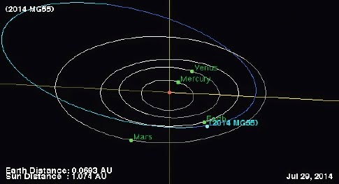
Asteroid 2014 MG55 passed by the Earth at a distance of about 10 080 000 km (26.22 times the average distance between the Earth and the Moon, or 6.7% of the average distance between the Earth an the Sun), slightly after 12.25 pm GMT on Friday 25 July 2014. There was no danger of the asteroid hitting us, though were it to do so it would have presented a serious threat. 2014 MG55 has an estimated equivalent diameter of 28-90 m (i.e. it is estimated that a spherical object with the same volume would be 28-90 m in diameter), and an object towards the upper end of this range would be predicted to be capable of passing through the Earth's atmosphere relatively intact, impacting the ground with an energy equivalent to about 35 megatons of TNT (roughly 2000 times the energy of the Hiroshima bomb). Such an event would result in a crater about 1 across, cause devastation on a wide scale and would have the potential to affect the climate globally for years after the impact event.

The calculated orbit of 2014 MG55. JPL Small Body Database Browser.

2014 MJ55 was discovered on 27 June 2014 (28 days before its closest approach to the Earth) by the University of Hawaii's PANSTARRS telescope on Mount Haleakala on Maui. The designation 2014 MG55 implies that it was the 1382nd asteroid (asteroid G55) discovered in the second half of June 2014 (period 2014 M).

While 2014 MG55 occasionally comes near to the Earth, it does not actually cross our orbital path. It has an elliptical 1027 day orbit, at an angle of 9.8° to the plane of the Solar System, that takes it from 1.07 AU from the Sun (1.07 times the average distance at which the Earth orbits the Sun), slightly outside our orbit, to 2.91 AU from the Sun, (2.91 times the distance at which the Earth orbits the Sun, almost twice the distance at which the planet Mars orbits the Sun). As a Near Earth Object that remains strictly outside the orbit of the Earth it is classed as an Amor Family Asteroid.

See also...

 Asteroid 2014 OP2 passes the Earth.

Asteroid 2014 OP2 passed by the Earth at a distance of 199 700 km (0.52 times the average distance between the Earth and the Moon), at about 8.35 am GMT on Thursday 24 July 2014. There was no...


 Asteroid 2014 MJ55 passes the Earth.

Asteroid 2014 MJ55 passed by the Earth at a distance of about 11 080 000 km (28.83 times the average distance between the Earth and the Moon, or 7.4% of the average distance between the Earth and...


 Asteroid 2014 MA6 passes the Earth.

Asteroid 2014 MA6 passed by the Earth at a distance of 7 275 000 km (18.93 times the average distance between the Earth and the Moon, or 4.9% of the average distance between the Earth and the...


Follow Sciency Thoughts on Facebook.

Monday 28 July 2014

Magnitude 3.2 Earthquake in Payne County, Oklahoma.

The United States Geological Survey recorded a Magnitude 3.2 Earthquake at a depth of 4.5 km in northeast Payne County, Oklahoma, slightly before 5.20 pm local time (Slightly before 10.20 pm GMT) on Sunday 27 July 2014. There are no reports of any damage or injuries associated with this event, though it was felt locally.

The approximate location of the 27 June 2014 Payne County Earthquake. Google Maps.

Oklahoma is naturally prone to Earthquakes, particularly in the southwest of the state, near the Meers Fault Zone, but since 2009 has suffered a sharp increase in the number of small quakes in the central and northeast parts of the state. While most of these quakes have been quite small, a few have been large enough to potentially cause problems, and any unexplained increase in seismic activity is a cause for concern. 

In a paper published in the journal Geology on 26 March 2013, a team of geologists led by Katie Keranen of the ConocoPhillips School of Geology and Geophysics at the University of Oklahoma linked one of the largest of these quakes, a Magnitude 5.7 event in November 2011 which caused damage locally and was felt across 17 states, to the practice of pumping liquids (usually brine) into injection wells, which is common in the hydrocarbons industry and used to displace oil or gas, which can then be extracted from nearby extraction wells (where this is done in bursts at pressure to intentionally break up rock it is called hydraulic fracturing, or fracking). Significantly they suggested that the practice could lead to quakes years or even decades after the actual injection.

Witness accounts of quakes can help geologists to understand these events and the rock structures that cause them. If you felt this quake (or if you were in the area but did not, which is also useful information) you can report it to the USGS here.

See also...


The United States Geological Survey recorded a Magnitude 3.1 Earthquake at a depth of 2.4 km in southern Grant County...


The United States Geological Survey recorded a Magnitude 3.3 Earthquake at a depth of 4.4 km in southwest Grant County...


The United States Geological Survey recorded a Magnitude 3.6 Earthquake at a depth of 5.0 km in northern Lincoln County...


Follow Sciency Thoughts on Facebook.

A Turiasaurian Sauropod from the Late Jurassic of Portugal.

Sauropod Dinosaurs reached their most diverse in the Late Jurassic, with about 180 species described from around the world. The best known Sauropod faunas from this period are from the Morrison Formation in the United States, the Tendaguru Formation in Tanzania and the Iberian Peninsula. The Sauropod fauna of Iberia appears to be very similar to that of the Morrison Formation, but with two important differences. Firstly the Morrison Formation contains a range of Sauropods of different sizes, suggesting an ecological diversity of animals with different feeding strategies, while all the Iberian Sauropods appear to have been very large animals. It has been suggested that the niches occupied by smaller Sauropod Dinosaurs in the Morrison Formation may have been occupied by other, non-Sauropod herbivores in Iberia, though the absence of juvenile members of the known species cannot be explained this way. Secondly three of the Iberian species, Galveosaurus herreroi, Losillasaurus giganteus and Turiasaurus riodevensis (all from Spain) appear to form a distinct evolutionary lineage, outside the Neosauropoda, which has been named the Turiasauria. This group is entirely absent from North America, although isolated teeth and fragmentary remains from elsewhere in Europe and Tanzania have been attributed to it.

In a paper published in the Journal of Vertebrate Paleontology on 6 may 2014, Octávio Mateus of the Faculdade de Ciências e Tecnologia at the Universidade Nova de Lisboa and the Museu da Lourinhã, Philip Mannion of the Department of Earth Science and Engineering at Imperial College London and Paul Upchurch of the Department of Earth Sciences at University College London, describe a new species of Turiasaurian Sauropod from the Late Jurassic Lourinhã Formation of west-central Portugal.

The new Dinosaur is named Zby atlanticus, where ‘Zby’ honours the distinguished Russian-French palaeontologist Georges Zbyszewski, who spent much of his career studying the geology and palaeontology of Portugal, and ‘atlanticus’ refers to the site where the specimen was found, in a bay overlooking the Atlantic Ocean. Zby atlanticus is described from a right pectoral girdle (shoulder) and forelimb, plus an isolated tooth and parts of two vertebrae (check). It shows close affinities to Turiasaurus riodevensis, but there are sufficient differences on the limited available material to merit placing it in a different genus.

Locality of Zby atlanticus. (A) photograph of the elements in the ground; (B) line drawing of the elements in the ground. Numbers refer to (1) chevron; (2) scapula; (3) coracoid; (4) humerus; (5) ulna; (6) radius; (7) metacarpal I; (8) metacarpal III; (9) metacarpal IV; (10) manual ungual phalanx I-2; (11) tooth. Note that the additional two manual phalanges are not visible in this view. Scale bar equals 500 mm. Mateus et al. (2014).

Silhouette outline and line drawings of Zby atlanticus. (A) Humerus; (B) tooth; (C) coracoid; (D) scapula; (E) chevron; (F) radius; (G) ulna; (H) metacarpal I; (I) metacarpal III; (J) metacarpal IV; (K) manual phalanx I-1; (L) manual ungual claw I-2. Figures not proportionally to scale to one another. Mateus et al. (2014).

See also…


Titanosaurs were the dominant group of Sauropod Dinosaurs in many Late Cretaceous faunas. The group included the very largest Sauropods, and therefore also the very largest known land animals of any type. Titanosaur remains were first found in Madagascar in the 1890s, though the first species from Madagascar...


Sauropod dinosaurs were massive, long-necked...


Sauropod dinosaurs were massive, long-necked, long-tailed creatures that have long been regarded as the largest land animals ever to have lived. They reached...


Follow Sciency Thoughts on Facebook.

A new species of Braconid Wasp from Madagascar.

Braconid Wasps are small parasitic Wasps which can typically lay several eggs on a large host species (typically another Insect or Spider). The larval Wasps grow inside the host, before emerging to pupate on its surface; unusually for parasitic Wasps the host is not usually killed. Braconid Wasps of the Afro-tropical region are very poorly understood, with little taxonomic sampling in many areas, and no overall phylogenetic analysis of relationships between different groups having been carried out to date.

In a paper published in the journal Zootaxa on 16 July 2014, Miles Zhang and Barbara Sharanowski of the Department of Entomology at the University of Manitoba, describe a new species of Braconid Wasp from the Ranomafana National Park in Madagascar.

The new species is placed in the genus Eudiospilus, which currently contains only a single species found in Cameroon and Angola, and is given the specific name rubrumbarus, meaning ‘Red Baron’ in honour of Baron Manfred von Richthofen, due to the resemblance of the head colouration to a leather aviator helmet. Eudiospilus rubrumbarus is described from two female specimens. These are 6.5 mm in length and bright yellow in colour except for the head which is black.

Eudiospilus rubrumbarus in lateral view. Zhang & Sharanowski (2014).

See also…


Braconid Wasps are parasitoid Wasps (i.e. Wasps whose larvae mature inside the living bodies of other insects, which generally die as a result) related to the more familiar Ichneumon Wasps, but much smaller. They have a formidable appearance, but are in fact stingless, making them harmless to non-host species. There are about...


Braconid Wasps are parasitoid Wasps (i.e. Wasps whose larvae mature inside the living bodies of other insects, which generally die as a result) related to the more familiar Ichneumon Wasps, but much smaller. They have a formidable appearance, but are in fact stingless, making them harmless to non-host species. There are about 150 000 known species found across the globe.


 Three new species of Braconid Wasps from the Late Cretaceous of Magadan Province in the Russian Far East.

Braconid Wasps are parasitoid Wasps (Wasp's whose larvae grow inside the bodies of other insects) related to Ichneumon Wasps, but...


Follow Sciency Thoughts on Facebook.