
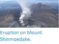
The Japan Meteorological Agency has expanded the warning area around Mount Shinmoedake to 4 km, a 1421 m volcano that forms part of the Kirishima Volcanic Complex on southern Kyūshū Island, following two large explosions on Saturday 10 March 2018. The volcano erupted slightly before 2.00 am and again slightly before 4.30 am, throwing rocks up to 1800 m from its crater, and produced an ash column that rose to an altitude of about 4.5 km.

Eruption on Mount Shinmoedake on 10 March 2018. Asahi Shimbun.
Japan has a complex tectonic situation, with parts of the country on
four different tectonic plates. Kyūshū Island lies at the northeast end of the Ryukyu Island Arc, which
sits on top of the boundary between the Eurasian and Philippine Plates.
The Philippine Plate is being subducted beneath the Eurasian Plate, in
the Ryukyo Trench, to the Southeast of the Islands. As it is drawn into
the interior of the Earth, the tectonic plate is partially melted by the
heat of the Earth's interior, and liquid magma rises up through the
overlying Eurasian Plate to form the volcanoes of the Ryukyu Islands and Kyūshū.

The movement of the Pacific and Philippine Plates beneath eastern Honshu. Laurent Jolivet/Institut des Sciences de la Terre d'Orléans/Sciences de la Terre et de l'Environnement.
See also....


Follow Sciency Thoughts on Facebook.