
The United States Geological Survey
recorded a Magnitude 5.2 Earthquake at a depth of 94.1 km about 27 km
off the southeast coast of the Rota Island, a US possession in the
Northern Mariana Islands, slightly after 10.40 pm local time (slightly after 12.40 pm GMT) on Saturday 19 October 2019. There
are no reports of any
casualties
this event, though it was felt across the Northern Marianas Islands and Guam.


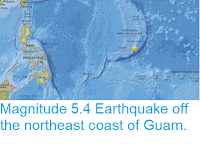
The approximate location of the 19 September 2019 Rota Island Earthquake. USGS.
The volcanic Mariana Islands are located on the eastern margin of the
Philippine Plate, close to its margin with the Pacific Plate. The
Pacific Plate is being subducted beneath the Philippine Plate along the
Mariana Trench. This is not a smooth process, an the plates constantly stick
together then break apart again as the pressure builds up, resulting in
Earthquakes.

Simplified diagram of the subduction of the Pacific Plate beneath the
Philippine plate, and how this fuels the volcanoes of the Mariana
Islands. NOAA Ocean Explorer.
Witness
accounts of quakes can help geologists to understand these events and
the rock structures that cause them. If you felt this quake (or if you
were in the area but did not, which is also useful information) you can
report it to the USGS here.
See also...


Follow Sciency Thoughts on Facebook.