
The Philippine Institute of Volcanology and Seismology recorded a Magnitude 6.3 Earthquake at a depth of 8 km about 22km to the southeast of the town of Tulunan in Cotabato Province on Mindanao
Island, Philippines, slightly after 7.35 pm local time (slightly after 11.35 am GMT) on Wednesday 16 October 2019. The Earthquake is known to have killed at least five people and injured at least fifty more, including two people killed and eighteen injured in a landslide in the town of Magsaysay in Davao del Sur Province, a child killed in a building collapse in the same town, and another child killed when a wall collapsed in Maguindanao Province. People have reported feeling the quake across the southern Philippines. More than 200 aftershocks have been reported following the initial event.

Damage to a building in the city of Digos in Davao del Sur Province, Mindanao Island, following an Earthquake on 16 October 2019. Manman Dejeto/AFP.
The geology of the central Philippines is Complex. The west of Mindanao
Island is located on the Banda (or Sunda) Microplate, and the east on
the Philippine Plate, which is being subducted beneath the Sunda (or
Banda) Microplate along the central part of the island. Immediately to
the east of the Island the Pacific Plate is being subducted along the
Philippine Trench, and passes beneath eastern Mindanao as it sinks into
the Earth. This is not a smooth process, an the plates constantly stick
together then break apart again as the pressure builds up, resulting in
Earthquakes.

Subduction beneath the Philippines. Yves Descatoire/Singapore Earth Observatory.
Witness
accounts of Earthquakes can help geologists to understand these events,
and the structures that cause them. The international non-profit
organisation Earthquake Report is interested in hearing from people who may have felt this event; if you felt this quake then you can report it to Earthquake Report here.

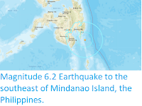
The
location of the 16 October 2019 Cotabato Province Earthquake. Contour
lines show rates of movement during the quake, the red line is a
boundary between two tectonic plates, in this case the Pacific and Philippine plates. USGS.
See also...


Follow Sciency Thoughts on
Facebook.