The Indonesian province of West Papua was hit by a Magnitude 7.0 Earthquake at a depth of 68 km beneath its Central Highlands, slightly after 1.40 pm local time (slightly after 4.40 am GMT) on Saturday 6 April 2013, according to the United States Geological Survey. This is a big, quake, but moderately deep, so it is unlikely to have caused widespread destruction; the United States Geological Survey estimate there is a 35% chance the quake may have led to loss of life. It will have been felt over a large area, and witnesses have reported feeling the quake on Bali. Large Earthquakes in Indonesia have caused major tsunami events in the past, but this is not likely on this occasion as the quake is both deep and on-land.
The epicenter of the 6 April Earthquake (black star) and the areas likely to have suffered the worst damage. Note that the epicenter does not fall within the area likely to suffer the worst destruction, which is in higher mountains slightly to the north. Damage to buildings is only likely within the yellow and green areas, the blue areas are likely yo have felt some shaking. USGS.
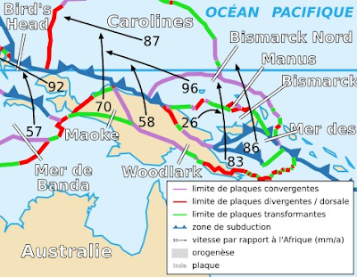
The tectonic situation underlying West Papua is complex, with the island being made up of a number of small tectonic plates being squeezed between the larger Pacific and Australian plates. The area affected by the 6 April quake lies on the boundary between the Maoke Plate, which underlies much of West Papua and the Woodlark Plate, which underlies much of the east of the island. Other parts of the island lie on the Bird's Head, Australian and South Bismarck Plates. To the north of West Papua the Caroline Plate is being subducted in the Manus Trench, which is parallel to the northern shore of the island.
The plates underlying West Papua and the surrounding area. Wikipedia.
See also Eruption on Manam Motu, Ash cloud reported over Karkar Island, north of Papua New Guinea, Magnitude 6.8 Earthquake hits Bam Island and Earthquakes on Sciency Thoughts YouTube.
Follow Sciency Thoughts on Facebook.


