Wednesday 30 March 2016

Asteroid 2016 FU6 passes the Earth.

Asteroid 2016 FU6 passed by the Earth at a distance of 178 900 km (0.47 times the average distance between the Earth and the Moon, or 0.12% of the average distance between the Earth and the Sun; 176 900 km above the orbit at which the satellites supporting GPS systems operate), slightly before 7.20 pm GMT on Friday 25 March March 2016. There was no danger of the asteroid hitting us, though had it done so it would have presented no threat. 2016 FU6 has an estimated equivalent diameter of 3-9 m (i.e. it is estimated that a spherical object with the same volume would be 3-9 m in diameter), and an object of this size would be expected to explode in an airburst (an explosion caused by superheating from friction with the Earth's atmosphere, which is greater than that caused by simply falling, due to the orbital momentum of the asteroid) in the atmosphere more than 32 km above the ground, with only fragmentary material reaching the Earth's surface.

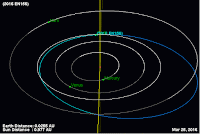
 The calculated orbit of  2016 FU6JPL Small Body Database.
 
2016 FU6 was discovered on 27 March 2016 (two days after its closest approach to the Earth) by the University of Arizona's Mt. Lemmon Survey at the Steward Observatory on Mount Lemmon in the Catalina Mountains north of Tucson. The designation 2016 FU6 implies that the asteroid was the 170th object (object U6) discovered in the second half of March 2016 (period 2016 F).
 
2016 FU6 has a 509 day orbital period and an eccentric orbit tilted at an angle of 2.23° to the plane of the Solar System that takes it from 0.74 AU from the Sun (i.e. 79% of the average distance at which the Earth orbits the Sun, outside the orbit of Venus) to 1.71 AU from the Sun (i.e. 171% of the average distance at which the Earth orbits the Sun, considerably more than the distance at which Mars orbits the Sun). It is therefore classed as an Apollo Group Asteroid (an asteroid that is on average further from the Sun than the Earth, but which does get closer).
 
This also means that 2016 FU6 has occasional close encounters with the planets Mars and Venus. Its most recent close approach to Venus is calculated to have occurred in February 2009, and the most recent close encounter with Mars happened in July 1920 with the next predicted for September 2042. Asteroid orbits that have close encounters with multiple planets are considered to be quite unstable, as any perturbations can quickly become magnified, throwing the astroid onto a new orbital path.
 
See also...
 
http://sciencythoughts.blogspot.co.uk/2016/03/asteroid-455148-1994-ug-passes-earth.htmlAsteroid (455148) 1994 UG passes the Earth.                                                      Asteroid (455148) 1994 UG passed by the Earth at a distance of 6 644 000 km (17.3 times the average distance between the Earth and the Moon, or 4.44% of the average distance between the Earth and the...
http://sciencythoughts.blogspot.co.uk/2016/03/asteroid-2016-en156-passes-earth.htmlAsteroid 2016 EN156 passes the Earth.  Asteroid 2016 EN156 passed by the Earth at a distance of 601 800 km (1.57 times the average distance between the Earth and the Moon, or 0.40% of the average distance between the Earth and the Sun), slightly before 6.25 am GMT on Saturday 19...
http://sciencythoughts.blogspot.co.uk/2016/03/asteroid-2016-em156-passes-earth.htmlAsteroid 2016 EM156 passes the Earth. Asteroid 2016 EM156 passed by the Earth at a distance of 531 500 km (1.38 times the average distance between the Earth and the Moon, or 0.56% of the average distance between the Earth and the Sun), slightly before 6.25 am GMT on Wednesday 16...
Follow Sciency Thoughts on Facebook.
  

Magnitude 4.2 Earthquake in Logan County, Oklahoma.

The United States Geological Survey recorded a Magnitude 4.2 Earthquake at a depth of 4 km slightly to the north of Crescent City in Logan County County, Oklahoma, slightly before 11.55 pm local time on Monday 28 March 2016 (slightly before 4.55 am on Tuesday 29 March GMT). There are no reports of any damage or injuries associated with this Earthquake, but it was felt across a large area of north-central Oklahoma.

The approximate location of the 15 November 2015 Woods County Earthquake. Google Maps.

Oklahoma is naturally prone to Earthquakes, particularly in the southwest of the state, near the Meers Fault Zone, but since 2009 has suffered a sharp increase in the number of small quakes in the central and northeast parts of the state. While most of these quakes have been quite small, a few have been large enough to potentially cause problems, and any unexplained increase in seismic activity is a cause for concern. 

In a paper published in the journal Geology on 26 March 2013, a team of geologists led by Katie Keranen of the ConocoPhillips School of Geology and Geophysics at the University of Oklahoma linked one of the largest of these quakes, a Magnitude 5.7 event in November 2011 which caused damage locally and was felt across 17 states, to the practice of pumping liquids (usually brine) into injection wells, which is common in the hydrocarbons industry and used to displace oil or gas, which can then be extracted from nearby extraction wells (where this is done in bursts at pressure to intentionally break up rock it is called hydraulic fracturing, or fracking). Significantly they suggested that the practice could lead to quakes years or even decades after the actual injection.

Witness accounts of Earthquakes can help geologists to understand these events, and the structures that cause them. The international non-profit organization Earthquake Report is interested in hearing from people who may have felt this event; if you felt this quake then you can report it to Earthquake Report here.
 
 See also...

http://sciencythoughts.blogspot.co.uk/2015/11/magnitude-43-earthquake-in-woods-county.htmlMagnitude 4.3 Earthquake in Woods County, Oklahoma.                                              The United States Geological Survey recorded a Magnitude 4.3 Earthquake at a depth of 5 km in...
http://sciencythoughts.blogspot.co.uk/2015/08/magnitude-37-earthquake-in-oklahoma.htmlMagnitude 3.7 Earthquake in Oklahoma County, Oklahoma.                                     The United States Geological Survey recorded a Magnitude 3.7 Earthquake at a depth of 5 km in northern Noble County, Oklahoma, before 7.20 am local...
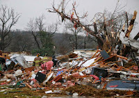
One man has died and at least 24 other have been injured following an outbreak of tornadoes across Oklahoma and parts of Arkansas on Thursday 26 March 2015. The dead man is reported to have died while trying to aid his injured father at the River...
Follow Sciency Thoughts on Facebook.

Tuesday 29 March 2016

Haya griva: A new speciemen of an enigmatic Cretaceous Dinosaur from the Cretaceous of Mongolia.

In 2011 a group of palaeontologists led by Peter Makovicky of the Department of Geology at the Field Museum of Natural History in Chicago described a curious Ornithischian Dinosaur from the Late Cretaceous Javkhlant Formation of the eastern Gobi Desert in Mongolia, one of a series of fossils collected by a joint expedition of the American Museum of Natural History and the Mongolian Academy of Sciences. Named Haya griva, it appeared to be a member of the Ornithopoda, the group that includes the Iguanodontids and Hadrosaurs, but to be a member of a lineage that had separated from other members of the group before these major lineages diverged. This was unexpected in a Late Cretaceous Dinosaur, as no previous 'primitive' members of the Ornithopoda had been found later than the early Cretaceous.

In a paper published in the American Museum Novitates on 18 February 2016, Mark Norell of the Division of Paleontology at the American Museum of Natural History and Daniel Barta of the Richard Gilder Graduate School and Division of Paleontology at the American Museum of Natural History, describe a new specimen of Haya griva from the Zos Canyon beds in the Nemegt Basin of southern Mongolia.

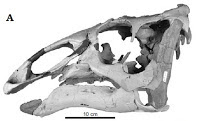
The new specimen was collected before the formal description of Haya griva, and was at the time considered too poorly preserved to be assigned to a species. However re-examination of the material leads Norell and Barta to conclude that it shows enough features unique to Haya griva fot it to be assigned to that species. The specimen comprises a partial skull, some loose teeth, a radius and ulna, several carpals, phalanges, and unguals, and a partial dorsal vertebral series and associated ribs. It is articulated, but had apparently been largely eroded away prior to its discovery.

Partial skeleton of Haya griva. Norell & Barta (2016).

This specimen does not add greatly to our knowledge of Hoya griva, however it does shed some light on the age of the beds which produced it. The fossil-bearing beds of the Gobi desert in Mongolia are notoriously hard to date with any precision, lacking any volcanic layers which can be used in dating, magnetic rocks holding clues to the orientation of the Earth's magnetic field, or even much in the way of pollen. The Javkhlant beds at Shine Us Khudug, which produced the first specimen of Haya griva, have previously been identified as being Santonian-Campanian in age (between 86.3 and 21.2 million years old), and the presence of the species in the Zos Canyon beds of the Nemegt Basin suggests that these must be of a similar age.

See also...

http://sciencythoughts.blogspot.co.uk/2015/12/morelladon-beltrani-styracosternan.htmlMorelladon beltrani: A Styracosternan Iguanodontid from the Early Cretaceous of Spain.                                                     Hadrosaurs, or Duck Billed Dinosaurs, were dominant herbivores in many ecosystems across the Northern Hemisphere in the Late Cretaceous, but the wider group of Iguandodontids from which they arose, the Styracosternans, first appeared in the Late Jurassic...
http://sciencythoughts.blogspot.co.uk/2015/11/probrachylophosaurus-bergei-new-species.htmlProbrachylophosaurus bergei: A new species of Brachylophosaurin Hadrosaur from the Late Cretaceous of northern Montana. Hadrosaurs were large, herbivorous Ornithischian Dinosaurs, commonly referred to as 'Duck-billed Dinosaurs', which...
http://sciencythoughts.blogspot.co.uk/2015/10/ugrunaaluk-kuukpikensis-new-species-of.htmlUgrunaaluk kuukpikensis: A new species of Hadrosaurid Dinosaur from the End Cretaceous of Alaska.                                  The Prince Creek Formation of Northern Alaska is noted for the production of numerous End...

 Follow Sciency Thoughts on Facebook.

Eruption on Mount Pavlof causes severe disruption to flights over Alaska.

Mount Pavlof, a 2.5 km high stratovolcano (cone-shaped volcano made up of layers of ash and lava) on the Alskan Peninsula, underwent a significant eruption slightly before 4 pm local time on Sunday 27 March 2016, producing an ash column 11.3 km high that drifted 650 km to the northeast. There are no reports of any ashfalls affecting local communities (which are mostly to the southwest of the volcano), however the ash cloud has cut across flight paths over Alaska, causing severe disruption to flights, as planes cannot safely approach such clouds. People in the area have also reported seeing lava fountains on the volcano. This is the first major eruption on Pavlof since November 2014.

Ash column over Mount Pavlof at about 7.00 pm on 27 March 2016. Colt Snapp/Twitter.

Pavlof is located between Cold Bay and Pavlof Bay near the tip of the Alaskan Peninsula. It has several active vents on its north and east flanks, it's remoteness and inaccessibility meaning that it is usually hard to tell from exactly which of these an individual eruption is occurring. Pavlof is considered to be one of America's most active volcanoes, and though it is located in a remote spot with no settlement close by, it still presents a serious threat to air-traffic.

 The approximate location of Mount Pavlof. Google Maps.

Volcanic ash is extremely hazardous to aircraft in a number of ways. At its most obvious it is opaque, both visually and to radar. Then it is abrasive, ash particles physically scour aircraft, damaging components and frosting windows. However the ash is most dangerous when it is sucked into jet engines, here the high temperatures can melt the tiny silica particles, forming volcanic glass which then clogs engine. When this happens the only hope the aircraft has is to dive sharply, in the hope that cold air passing through the engine during the descent will cause the glass to shatter, allowing the engine to be restarted. Obviously this is a procedure that pilots try to avoid having to perform.

The volcanoes of the Alaskan Peninsula and Aleutian Islands are fed by magma rising from the Pacific Plate, which is being subducted beneath the North American Plate to the south along the Aleutian Trench. As the subducting plate sinks into the Earth it is subjected to enormous heat and pressure, causing more volatile minerals to melt. These then rise through the overlying North American plate as magma, fueling the Alaskan volcanoes.

How the subduction of the Pacific Plate beneath the North American Plate fuels the volcanoes of Alsaska. Alaska Volcano Observatory.

See also...

http://sciencythoughts.blogspot.co.uk/2014/06/eruptions-on-mount-pavlof-on-alaskan.htmlEruptions on Mount Pavlof, on the Alaskan Peninsula.                                                  Mount Pavlof, a 2.5 km high stratovolcano began erupting on Saturday 31 May 2014, for the first time since the preceding September, according to the Alaska Volcano Observatory. This...
http://sciencythoughts.blogspot.co.uk/2013/09/magnitude-70-earthquake-in-aleutian.htmlMagnitude 7.0 Earthquake in the Aleutian Islands.                                                         The United States Geological Survey recorded a Magnitude 7.0 Earthquake at a depth of 33.5 km to the south of the Andreanof...
http://sciencythoughts.blogspot.co.uk/2013/08/eruption-on-mount-veniaminof.htmlEruption on Mount Veniaminof. Mount Veniaminof, an Alaskan volcano which has been experiencing low level activity since June, erupted suddenly on Friday 30 August, sending a column of ash 4.8 km into the air, according to the Alaska Volcano Observatory. There is no direct danger to anybody...
Follow Sciency Thoughts on Facebook.
 

Monday 28 March 2016

Haploperla triangulata: A new species of Stonefly from Qinghai Province, China.

Stoneflys, Plecoptera, are considered to be the most primitive group of Neopteran Insects (Insects capable of flexing their wings over their abdomens; essentially all winged Insects except Deagonflies, Damselflies, Mayflies and some extinct groups). They have a simple, generalized bodyplan compared to more 'advanced' Insects, and have aquatic larvae that retain external wings till their final metamorphosis, when they gain external wings and leave the water (some forms have been found with larvae that can survive in moist terrestrial habitats, or that remain in the water as adults). Members of the Plecoptera appeared in the Carboniferous, though the group gained its maximum diversity in the Cretaceous.

In a paper published in the journal ZooKeys on 15 March 2016, Zhi-Teng Chen and Yu-Zhou Du of the School of Horticulture and Plant Protection & Institute of Applied Entomology at Yangzhou University, describe a new species of Stinefly from the Huangzhong County in Qinghai Province, China.

The new species is placed in the genus Haploperla and given the specific name triangulata, in reference to the shape of the epiproct (plate above the anus). The species is described from one male and seven females. Both sexes are pale yellow in culture, with paler heads and brown markings. Females are slightly larger than the male, with forewings reaching 7.0-7.5 mm, compared to 6.5-7.0 mm.

Haploperla triangulata. (9) Male in dorsal view. (10) Female in dorsal view. Scale bars are 1 mm. Chen & Du (2016).

See also...

http://sciencythoughts.blogspot.co.uk/2014/01/interpreting-insect-trace-fossil-from.htmlInterpreting an Insect trace fossil from the Late Carboniferous of Massachusetts.           In a paper published in the Proceedings of the National Academy of Sciences of the United States of America in April 2011, Richard Knecht of the Department of Geology at Tufts University...
Follow Sciency Thoughts on Facebook.
 

Eremogone ali-gulii: A new species of Eremogone from eastern Turkey.

Eremogones are small perennial flower in the Carnation family, Caryophyllaceae. They have thread-like leaves and small white (or sometimes pink) flowers, and tend to grow in thick clumps from woody horizontal stems. Ergomogones favour warm, dry climates. 

In a paper published in the journal PhytoKeys on 25 February 2016, Murat Koç of the Department of Biology and Animal Production High School at Bozok University and Ergin Hamzaoğlu of the Department of Elementary Education at Gazi University describe a new species of Eremogone from Erzurum Province in eastern Turkey.

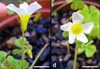
The new species is named Eremogone ali-gulii in honour of the hydrobiologist Ali Gül of the Gazi Faculty of Education at Gazi University. It is a tufted perennial herb reaching 10-18 cm in height, producing white flowers from June to July. The plant was found growing on serpentine soils (nutrient poor non-calcitic alkaline soils, typically derived from volcanic or metamorphic rocks) at two sites, one on Kop mountain between Bayburt and Aşkale and the other near Karasu village between Erzurum and Erzincan.

Eremogone ali-gulii, whole plant. Koç & Hamzaoğlu (2016).

Eremogone ali-gulii  has been found growing only at two locations, both of which are prone to human disturbances such as grazing animals or land-use change. For this reason Koç and Hamzaoğlu recommend that it be classed as Endangered under the terms of the International Union for the Conservation of Nature’s Red List of Threatened Species.

 See also...

http://sciencythoughts.blogspot.co.uk/2015/02/two-new-species-of-oxalis-from-northern.htmlTwo new species of Oxalis from Northern Cape Province, South Africa.                             Plants of the genus Oxalis are found in South America, where there are around 250 species of herbs, shrubs and vines, and Southern Africa, where there are around 210 species, all of which are bulbous perennials...
http://sciencythoughts.blogspot.co.uk/2014/12/a-new-species-of-burr-marigold-from.htmlA new species of Burr Marigold from Rapa in the Austral Islands, French Polynesia.            The Austral Islands are a group of eight volcanic islands to the south of the Society Islands in the southern Pacific Ocean. Rapa is the second largest of these...
http://sciencythoughts.blogspot.co.uk/2014/10/a-new-species-of-tulip-from-anhui.htmlA new species of Tulip from Anhui Province in eastern China.                                        Tulips of the genus Amana are found in eastern Asia. They are very similar to the Tulips of Western Asia and Europe, which are placed in the genus Tulipa, differing only in the presence of bracts on the upper part of...

Follow Sciency Thoughts on Facebook.
Middle Palaeolithic stone tools from the Nejd Region of Saudi Arabia.

For many years much of the Arabian peninsula was largely overlooked by palaeoarchaeologists who tended to concentrate on the more accessible Levant region of the Middle East, despite surveys in the 1970s and early 1980s which suggested there was much material to be found in Arabia. However in recent years the peninsula has been recognized as an important route for early Humans (and earlier Hominins) dispersing from Africa into Asia, and more attention has begun to be paid to the region.

In a paper published in the Journal of Field Archaeology on 16 March 2016, a team of archaeologists led by Huw Groucutt of the School of Archaeology at the University of Oxford describe a series of new sites yielding Middle Palaeolithic material from the Nejd Region of central Saudi Arabia.

The Nejd region has yielded a number of previous Middle Palaeolithic sites, suggesting that Humans or Hominins using these technologies were present in the area. Groucott et al. identified likely sites be examination of satelite images of palaeodrainage systems (dried up rivers, lakes etc.), then carrying out foot surveys of these sites. None of the sites examined has been dated yet, but rather are described as Middle Palaeolithic on the basis of the technologies used.

The first site examined Al Qana-1, is located on the outskirts of the village of Al Qana on the southern fringe of the Nafud Desert. The area has previously yielded Neolithic remains, an was identified as having sediments likely to be of interest in satelite images. A series of artifacts were found on the surface the edge of an aluvial fan extending from mountains to the south, which extends beneath the surrounding dunes, indicating that it is older. Three small test trenches dug into the sediments yielded no buried artifacts.

Test trench at Al Qana-1, dark blue items on surface are all Middle Palaeolithic rhyolite lithics. Groucott et al. (2016).

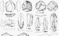
The lithic (stone) tools recovered at Al Qana-1 are made of dark blue rhyolite (a silica-rich volcanic rock) with numerous phenocrysts (large, visible crystals of a different mineral). A rhyolite dyke (volcanic intrusion) was located close to the site, suggesting that the material used was of local origin. Nevertheless rhyolite stone tools are unusual, and have not previously been described from Saudi Arabia; the only previously described rhyolite tool assemblage from Arabia comes from the late Middle Palaeolithic Wadi Surdud site in Yemen. A total of 40 artifacts were collected from Al Qana-1, these being predominantly discoidal cores (cores from which flakes have been chipped away), similar to Levallois cores (in Levallois technology initial flakes are chipped away from a central core, in order to produce a worked core from which more specialized flakes can be chipped for use as tools).

Al Qana-1 lithics, all rhyolite. (A) Levallois-like discoidal core; (B, C) Discoidal cores; (D) Levallois-like discoidal core; (E, F) Flakes; (G) Side retouched flake; (H) overshot discoidal flake. Groucott et al. (2016).

The second site examined, Shuwaymis 11, is beside a river channel connested to a tributaty of the Wadi al Batin, which flows from the Shuwaymis Region (noted for its Neolithic rock art) towards Kuwait. The channel cuts through a basalt lava flow, though most of the material found here was again of rhyolite, this being orange-brown in colour and apparently derived from nodules within the river. The tools were concentrated in a small area, roughly 60 m by 20 m, and were predominantly of the Levallois-type.

Shuwaymis 11 lithics, all rhyolite. (A, B) Preferential Levallois core with centripetal preparation; (C) Bidirectional Levallois core with centripetal preparation. Groucott et al. (2016).

The third site examined Dawadmi-23, is located on top of one of the numerous volcanic dykes cutting through the area around the town of Dawadmi, which comprises material that was injected into overlying sedimentary rock, and which has persisted after that rock was eroded away, forming a raised platform. The Dawadmi area area is known for a number of Early Palaeolithic sites, though relatively little Middle Palaeolithic material has been found there. The Dawadmi-23 site is about 90 km to the northwest of the town of Dawadmi, close to the villages of Badayi bin Naim and Al Mushash. The dyke which produced the material is felsic (silicone rich) and relatively unfractured compared to other dykes in the area, suggesting that it may comprise more suitable material for tool-making. A number of Early Palaeolithic hand-axes were found downslope of the dyke, with Middle Palaeolithic material upslope, closer to the exposed surface of the dyke.

Dawadmi-23, a dense combination of natural and knapped stone beneath a dyke (back left). Groucott et al. (2016).

The site produced a low density assemblage, comprising a few hundred Middle Palaeolithic objects made from a fine-grianed microgranite. This tool assemblage is dominated by Levallois-type cores, though it demonstrates a number of different approaches to toolmaking being used.

Dawadmi-23 lithics, all micogranite. (A) Preferential Levallois core with centripetal preparation; (B, C) Bidirectional Levallois core with centripetal preparation; (D) Core for a preferential flake, but non-Levallois volumetric configuration; (E) Pointed flake with bidirectional scar pattern; (F) Débordant-like flake. Groucott et al. (2016).

The forth site examined Az Zu’aynah-2, is located on a food plain within a stiil active wadi (channel through which water flows following episodes of rain) to the east of Dawadmi, a few meters above the active channel. This site yielded a low-density assemblage of Levallois-type artifacts, mostly made from a fine-grained material, though a single rhyolite object was found.

Az Zu’aynah-2 lithics, all fine grained igneous raw material other than A (rhyolite). (A, B) Recurrent centripetal Levallois cores; (C–E) Levallois flakes. Groucott et al. (2016).

The final site discussed, Jebel Abyad-1, is located on an isolated quartz hill in the Dawadmi area. A small number of Early Palaeolithic quartz habdaxes were found close to the hill, and a small number of Middle Palaeolithic objects about half way up one slope, though it is possible that more objects were overlooked due to the large amount of fractured quartz present at the site. The Middle Palaeolithic material consisted of a number of Levallois cores.

Jebel Abyad-1 lithics, all quartz. (A, C) preferential Levallois core with centripetal preparation; (B) Discoidal core; (D, E) Thick flakes with faceted platforms, centripetal scar patterns and cortex at distal ends. Groucott et al. (2016).

See also...

http://sciencythoughts.blogspot.co.uk/2014/10/acheulian-and-levallois-technologies.htmlAcheulian and Levallois technologies from a single Late Pleistocene site Armenia.        Stone tools associated with the Acheulian technology first appeared around 1.75 million years ago and spread across much of Eurasia from about 900 000 years...
http://sciencythoughts.blogspot.co.uk/2014/10/stone-tools-from-middle-to-late.htmlStone tools from the Middle to Late Pleistocene of the Nefud Desert.                 The Nefud Desert lies in the northwest of Saudi Arabia, and is thought to have been one of the key obstacles that early Humans, and other Hominids, had to pass as they expanded out of Africa...
The Thar Desert covers over  200,000 km² of land in the northwest part of the Indian Subcontinent, straddling the border between Pakistan and India. It marks the boundary between the deserts of North Africa and the...
Follow Sciency Thoughts on Facebook.

Echinolittorina nielseni: A new species of Periwinkle from the Pleistocene-Holocene of northern Chile.

Periwinkles, Littorinidae, are abundant shallow marine Gastropods, the shells of which are familiar from neaches around the world. However, while they have a fossil record dating back to at least the Eocene, fossil Periwinkles are rather rare, as they live high on the shore in rocky environments, a very bad environment for fossil preservation. To make matters worse, Periwinkle species are very hard to tell apart, as they tend to be similar and their growth is heavily influenced by their environment, so that members of different species growing in similar environments will often resemble one-another more closely than members of the same species growing in different environments.

In a paper published in the journal Palaeontologica Electronica in February 2016, Juan Francisco Araya of the Departamento de Geología at the Universidad de Atacama and the Programa de Doctorado en Sistemática y Biodiversidad at the Universidad de Concepción , and David Reid of the Mollusca Research Group at the Natural History Museum describe a new species of Periwinkle from the upperficial deposits on the coast of Región de Atacama in northern Chile, thought to be no more than Pleistocene in age.

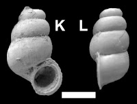
The new species is named Echinolittorina nielseni, in honour of Sven Nielsen of the Universidad Austral de Chile, for his work on Chilean fossil Molluscs. The species is described from a series of 23 specimens. These are large bodies Periwinkles (15.7–22.2 mm in height) with rounded whorls, a concave spire profile and 7-9 strong spiral ribs.

Shells of Echinolittorina nielseni. Araya & Reid (2016).

See also...

http://sciencythoughts.blogspot.co.uk/2014/10/fossil-land-snails-from-late.htmlFossil Land Snails from the Late Pleistocene of south central Jamaica.                                      Jamaica is considered to be a biodiversity hotspot for Land Snails, with over 505 species considered to be endemic to the island (i.e. coming from the island and not found anywhere else) and 562 species found on the island in total. This is despite the island...
http://sciencythoughts.blogspot.co.uk/2014/06/gastropod-predation-on-barnacles-in.htmlGastropod predation on Barnacles in the Late Pleistocene of southern South America. Muricid Gastropods (Murexes) are carnivorous Snails which are...
http://sciencythoughts.blogspot.co.uk/2014/02/three-new-species-of-vetigastropod.htmlThree new species of Vetigastropod Snails from the Plio-Pliestocene of The Philippines. Vetigastropods are considered to be the most ancient, and primative, group of Snails. They are exclusively marine, but found in almost all marine environments, from the intertidal zones to the deepest abysal...
Follow Sciency Thoughts on Facebook.