At the end of the last glaciation, the retreat of the ice exposed a scoured moraine landscape across Scandinavia and parts of northern Europe, into which groups of Human settlers began to move. These people are known as the Hamburgian Culture, after the type site, which lies slightly to the north of Hamburg and was excavated in the 1930s. The Hamburgian Culture lasted from about 14 700 to about 14 000 before the present, and used a modified form of the Palaeolithic Magdalenian tool-set. The Hamburgian Culture can be further divided into 'Classical' and 'Havelte' phases. based upon the form of projectile point used.
Exactly how these people dispersed into this landscape remains a matter of some controversy, with two predominant rival models having been applied. The Wave-of-advance model proposes that people move across a landscape in a homogeneous way, spreading out slowly from a common point of origin. The Leapfrog model proposed that people make relatively long 'hops' forming small, often ephemeral, settlements at scattered suitable sites and leaving large swaths of unsettled land in between such sites. Theoretically, the Leapfrog model should produce a small number of widely scattered settlements with little variation in technology (as people settle in parts of the landscape suited to their tools), whereas the Wave-of-advance model should produce more numerous evenly spaced settlements, with a more varied tool set (as people adjusted the tools needed to local conditions). On the whole, most post-Glacial expansions in Early Holocene Europe fit well with the Wave-of-advance model, but the Magdalenian, and in particular Hamburgian cultures seem to be better explained by the Leapfrog models.
Closely tied to the Leapfrog model is the concept of landscape learning. Landscape learning proposes that people moving into a new landscape will have a limited knowledge about the distribution of local resources, such as outcrops of workable stone, and the seasonal fluctuations of Animals and Plants. Such information is usually passed on within societies even when it is not regularly used, but a people entering a new landscape will need to acquire this knowledge for the first time, with failure to do so having severe effects, including local extinction.
The difference between these models is impossible to determine through direct examination of individual archaeological sites, but instead requires the accumulation of information from many different locations. This is particularly difficult for cultures such as the Hamburgian, for which sites are rare, particularly at the fringes of their activities, which for the Hamburgians was southern Scandinavia.
In a paper published in the Journal of Field Archaeology on 16 June 2022, Jesper Pedersen of Aarhus University, Martin Poulsen of Museum Sønderskov, and Felix Riede, also of Aarhus University, describe the discovery, excavation, and analysis of materials from a new Hamburgian site near the Jels Lake Complex in southern Denmark.
The Hamburgian tool-set is distinctive among Late and Final Palaeolithic technologies. The Hamburgians produced a unique type of asymmetric, single shouldered projectile-point (which became more extreme in nature in the later Havelte phase), combined with finely chiseled zinken and burin blades and scraping tools. Most of these tools are struck from from single-faced opposed-platform blade cores, and many tools are double-ended. There have been attempts at dividing the Hamburgian tool-set into several subcultures, but only two are generally recognised today, with the Classical phase restricted to sites in Germany and the Havelte phase pushing north and west into other regions, including southern Scandinavia.

The first Hamburgian sites in Denmark (and therefore the first such sites to the north of Germany) were discovered only in the 1980s, despite a long and rather thorough history of archaeological exploration within Denmark. The first of these sites, Jels 1 & Jels 2, were adjacent to the Jels Lake Complex, with a third site at nearby Slotseng appearing to support the idea of a cluster of settlements in this area. Subsequent Hamburgian sites have been found at Sølbjerg on the island of Lolland, and Krogsbølle on the island of Funen. A single site is known from Sweden, at Mölleröd in Skåne, Sweden's southernmost county. A scattering of individual tools is known from other locations in Denmark. These Scandinavian Hamburgian sites are all more than 100 km from the nearest sites in Germany, and represent the most northerly known Human settlements at the time.
This sparse distribution has been used to argue for a highly ephemeral culture, following Reindeer across the Steppes of Northern Europe and not settling in any one place for any length of time. However, application of radiometric dating methods to organic remains from Hamburgian sites in Germany and Northern Europe indicates that many of these sites were repeatedly occupied over long periods of time. As yet, only a single Danish site, Slotseng, has been dated in this way, with the results there suggesting that all of the material here was deposited in a single event, at the end of the Bølling/Meiendorf Warm Period, with Optically Stimulated Luminescence dating of material from Krogsbølle yielding a similar date, which appears to imply that the Hamburgian culture's occupation of Denmark was extremely brief.
The Jels 3 site is located at the southern end of the Jels Lakes. Hamburgian material in this area was first discovered in 1981, when an amateur archaeologist came across material by the Upper Lake (Ovsersø), which led to the excavations which uncovered the Jels 1 and Jels 2 sites. Both of these sites uncovered material consistent with the Havelte phase of the Hamburgian culture, although there were differences between the sites, with Jels 1 being interpreted as a workshop where stone tools were being made, whereas Jels 2 was interpreted as a hunting site. The Slotseng C is only 5 km from the Jels Lake Complex, and has yielded both lithic and faunal remains.
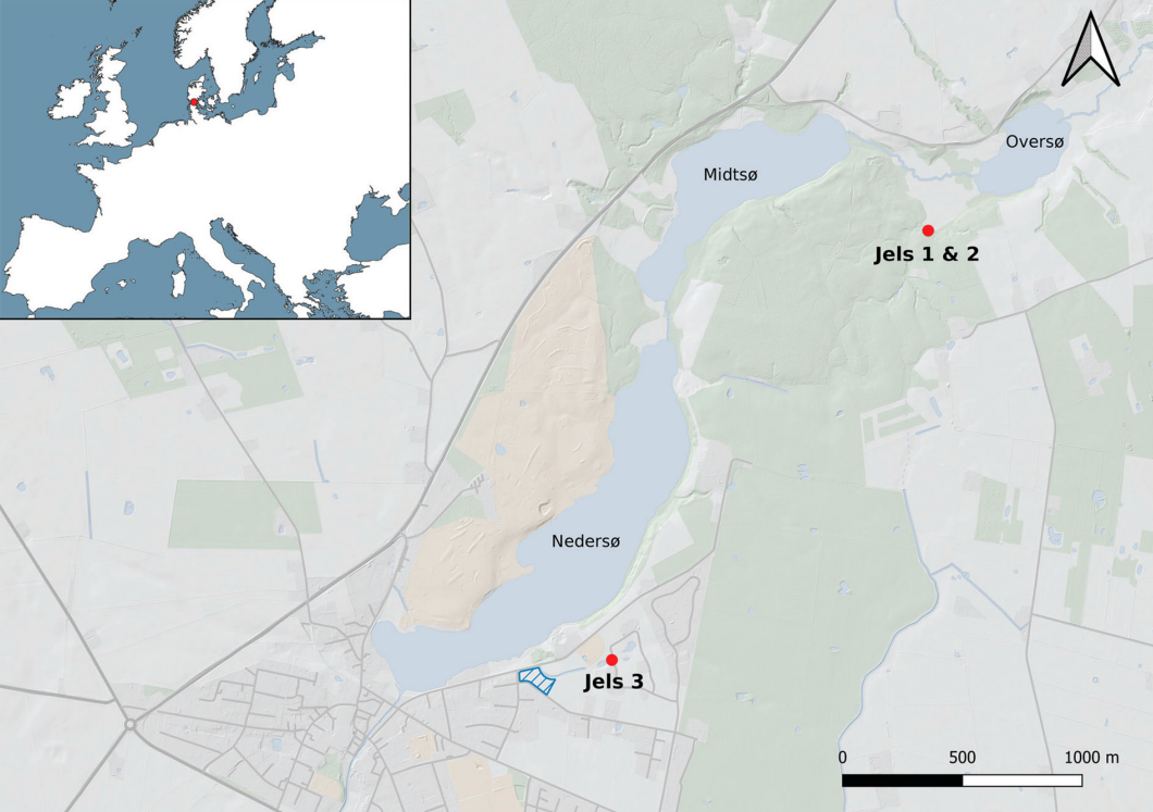
The Jels Lake Complex lies within a southwest pointing tunnel valley (U-shaped valley cut by a glacier), which itself forms part of the terminal moraine ridge system formed by the westernmost extension of the Scandinavian ice sheet during Greenland Stadial 2. The Jels 3 site is located on a sandy plateau 45-47.5 m above sealevel, 180 m to the south of the Lower Lake (Nedersø), and 32 m from a dried up watercourse.
The site was initially surveyed in October 2008 as part of preparation for the building of a new housing development. This survey consisted primarily of the digging of a series of trenches looking for Iron Age and Medieval material, but, due to the known proximity to the Jels 1 and Jels 2 sites, an area was also ploughed to look for ephemeral flint concentrations. In March 2009 flint tools of Late Palaeolithic manufacture were discovered in soil removed from trenches at the western end of the excavation site, leading to a revision of the investigation procedures. Subsequently the topsoil from a series of 1 m² grids was excavated, and the soil from them sieved for lithic artefacts, with the grid system being extended in the directions that produced artefacts, until a total area of 240 m² had been uncovered. A area of fine sand underlying the central part of the area where the topsoil was removed was subsequently divided into a 50 x 50 cm grid, with each grid section excavated in 10 cm sections until the production of material ceased.
A second surface survey in 2011 located a further 87 artefacts from a nearby area, many of which had a white or bluish patina, something common for Late Palaeothic flint tools in this region.
No organic material was recovered from Jels 3, but there were a total of 2846 lithic artefacts of probably Late Pleistocene origin. The grid system used produced 2652 of these artefacts, with 1835 coming from the sand layer and the remainder from the topsoil. The ploughed area yielded only 817 objects, which suggests (surprisingly) that the area has never been heavily ploughed for agricultural reasons. A series of test pits revealed that the sandy layer did not extend beyond the explored area. All of this strongly suggests that the sandy patch represents the original site of activity, which has not been subsequently disturbed by agricultural activity, but which will have been subjected to limited bio- and cryo-turbation. Twenty five of the lithic artefacts showed signs of burning, but this was spread across the site with no signs of the original fire.
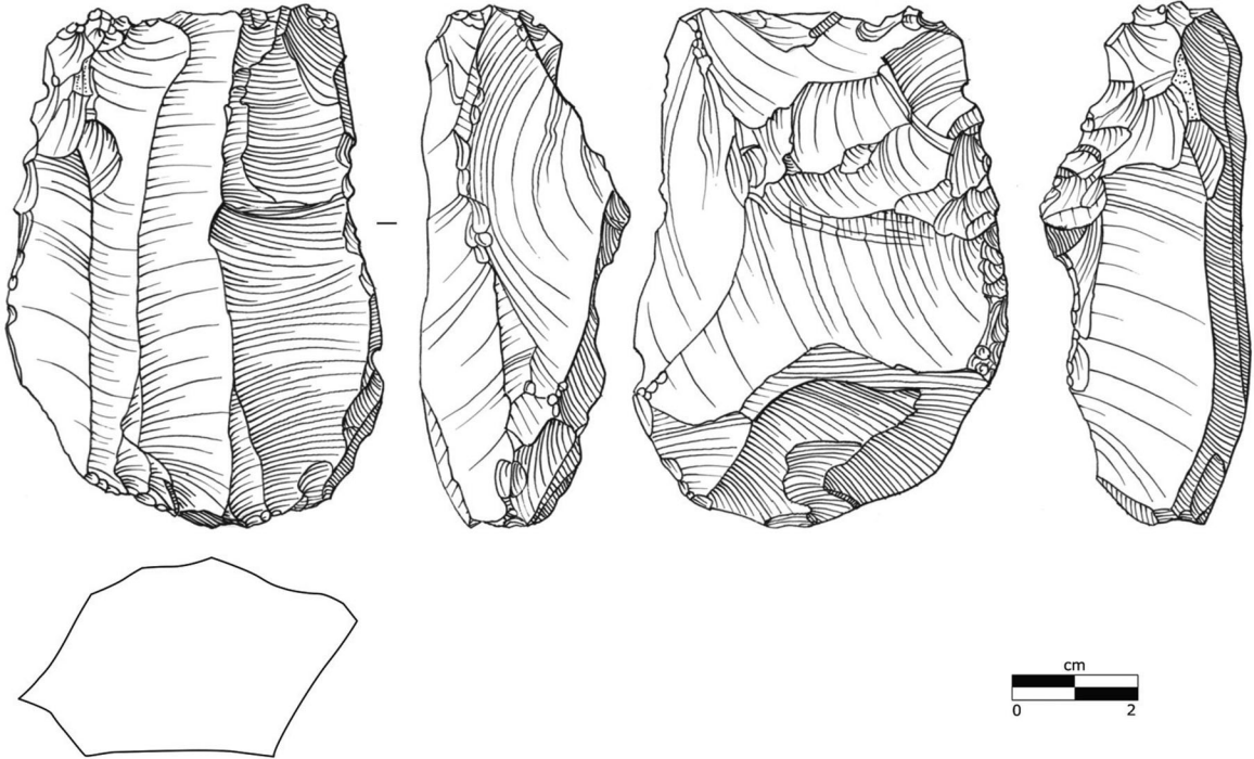
The majority of the material recovered from Jels 3 is the result of primary flint production; 90% of this being flakes, and the remaining 10% blades, blade fragments and cores. The remaining material consists of retouched tools and material. Four fragments of projectile points were found, one of which was hard to classify, but with the other three clearly representing the bases of Havelte tanged-points. The size and shape of these points makes it highly likely that they were used with a bow-and-arrow, although no such device has ever been recovered from a Hamburgian site. The Havelte tips from Jels 3 appear to have snapped on impact, although this is impossible to confirm. All of these blades appear to have been made using the same basic technique, although one shows signs of retouching.

Hamburgian stone tools tend to be very uniform in size, with Havelte tools being slightly smaller than Classical Hamburgian tools, whereas later Pleistocene tools tend to be more variable. There is currently some dispute about our ability to reconstruct the methods by which ancient stone tools were made, but we can say with some certainty that the makers of both Classical Hamburgian and Havelte tools appeared to preferentially start working on a tool from the lower left quadrant. All of the stone tools from Jels 3 for which an assessment was possible group strongly with Hamburgian tools from elsewhere on these features, differing from later Pleistocene technologies present in Denmark, such as those produced by the Federmesser or Bromme cultures.

The Jels 3 site represents a small, but tool rich site that can clearly be assigned to the Hamburgian culture. The most abundant tools here are burin blades and scrapers, and the range of tools differs from that present at Jels 1 and Jels 2, but not so much that post-depositional processes can be ruled out as a cause. Nevertheless, it is not impossible that the different tool abundances represent the Hamburgian people choosing different tools in a different environment, or occupying some sites for longer than others. Despite the limited size of the sample, and the relative paucity of some tools, the whole range of tools used by the Havelte phase of the Hamburgian culture are present in the Jels 3 assemblage.
No trace of a hearth could be found at Jels 3, but the presence of burned flints suggests that one was present. Pederson et al. suggest that the site was probably used by a small number of hunters, who stopped after a successful hunt to butcher a kill, prepare its hide, discard damaged tools and make new ones, an interpretation which fits well with previous assumptions about Hamburgian sites in southern Scandinavia being used only ephemerally.
Jels 3 forms part of one of two clusters of Hamburgian activity in Denmark, at the northernmost extent of that culture's range, and surrounded by an environment apparently devoid of other Human activity. This suggests that these people were capable of moving long distances fairly rapidly in order to find suitable environments, as predicted by the Leapfrog model. Further to the south, other Hamburgian settlements are closer together and appear to have been occupied for longer, potentially representing the filling in of gaps between far-flung communities as the landscape becomes more familiar.
A community moving into a new environment needs to overcome a variety of problems, ranging from how to find adequate resources to how indigenous populations might respond to them. In the case of this northward expansion of the Hamburgian people there was no indigenous population to compete (or trade) with, but the environment was very sparse in resources. In such a scenario a rapidly moving population could best survive by following a pathway through the new environment, requiring the learning of the availability of resources along that trail, rather than the whole landscape, although the wider landscape would probably be explored and utilised once the population became established.
The difficulty of becoming established in a new environment is largely dependent on how similar that environment is to the one being left. More recent migrations have been able to minimalise these differences by bringing familiar crops and livestock with them, but this was clearly not an option for the Palaeolithic Hamburgian hunters. However, their highly conservative tool-making technology is probably a sign of their bringing a reasonably strong cultural package, probably bringing their entire household with them as they followed Reindeer herds (which in turn would have kept one source of resources constant). The limited variation of tools is probably also a mark of a limited duration in the area; later Pleistocene peoples settling in the same area used a more varied set of tools because they were there for longer, giving generations of tool makers and users time to improve upon their methods, whereas the Hamburgians were present in limited numbers for a short period of time, giving little scope for innovation.
Following a known ecological resource, such as a herd of Reindeer, into an unfamiliar landscape may be a good way to form an initial bridgehead into a new environment. But this would have made the Hamburgians vulnerable to any environmental fluctuations which impacted that resource. The Hamburgian sites in Denmark date from a time of generally warming conditions, but also one in which severe climatic swings were still occurring. The Hamburgian culture appears to have disappeared in such a climatic fluctuation, as the climate went through a sudden bout of cooling, which probably caused the Danish Hamburgians to go locally extinct. Further to the south, the German Hamburgian population also disappeared, though it is unclear if these people actually died out, or were absorbed into a later cultural grouping, such as the End Palaeolithic Federmesser culture.
The Jels 3 site provides important new information on the presence of Havelte phase of the Hamburgian culture in southern Scandinavia. Although the site produces no novelty, it serves to underline the very conservative nature of this culture, and therefore lends support to the idea that this represents a people who had moved a long way into a new environment fairly rapidly, but who ultimately were not able to permanently establish themselves there.
See also...


Follow Sciency Thoughts on Facebook.
Follow Sciency Thoughts on Twitter.


.jpg)