Wednesday 30 January 2013

Dutch court fines Shell over pollution in ther Niger Delta.

A court in the Hague ruled that the Shell Petroleum Development Company of Nigeria Ltd., a subsidiary of oil company Shell must pay compensation to a Nigerian farmer for an oil leak that damaged fish ponds in his village. The damage was caused by a leak from a disused wellhead, dubbed the 'Christmas Tree' by locals because of its shape, which sprayed oil into fishponds in Icot Ada Udo village in the Niger Delta, belonging to farmer Friday Alfred Akpan, killing his fish and rendering the ponds unusable.

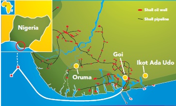
 The location of Ikot Ada Udo, and other villages involved in the case. Milieudefensie/Friends of the Earth Netherlands.

The wellhead was installed in the 1960s as part of an exploratory drilling program, then capped off and effectivelly abandonded when it was decided it would not be profitable to extract oil from the site. It began to leak in the 1990s; workers from Shell coming out when called upon by villigers to cary out ad-hoc repairs. This persisted until August 2007 when the Christmas Tree began to spray oil across the village. This (unsurprisingly) lead to disagreement between the villagers and Shell Nigeria, resulting in no work being carried out until government mediators became involved, with the leak finally sealed in November 2007.

The 'Christmas Tree' in Ikot Ada Udo village. Kadir van Lohuizen/NOOR/Milieudefensie/Friends of the Earth Netherlands.

Shell did not attempt a clean-up in the village until September 2008, by which time the rainy season had come, spreading the oil into fields and fishponds and contaminating the local water suply. Shell Nigeria provided the village with a water tank and pipes, but did not compensate them for the damage to crops and fish ponds.

This prompted Milieudefensie (Friends of the Earth Netherlands), working with NGO partners in Nigeria, to file a case on behalf of Mr Akpan in the Hague against both Shell Nigeria and its Anglo-Dutch parent company, along with four other cases on behalf of villagers in the Delta which the court rejected. Shell had argued that the spill was the result of sabotage, but the court rejected this on the grounds that Shell had an obligation to make the wellhead safe agianst such actions. Milieudefensie now plan to bring actions on behalf of other villagers in Ikot Ada Udo village, and ar considering appealing the other cases. Shell is also currently facing a law suit in London on behalf of 11 000 members of the Bodo community, who were affected by a major spill in 2008.

See also Pipeline explosion in Ogun State, southwest Nigeria, Oil barge explosion in Port of LagosAmnesty International reports on the 2012 Bodo Oil SpillExplosion aboard oil vessel in Port Harcourt, Nigeria, and Oil spill in Bayelsa State, Nigeria.
Follow Sciency Thoughts on Facebook.
 

Monday 28 January 2013

Magnitude 6.0 Earthquake in eastern Kazakhstan.

On Monday 28 January 2013, slightly before 10.40 pm local time (slightly before 4.40 pm, GMT), the United States Geological Survey recorded a Magnitude 6.0 Earthquake at a depth of 15 km in the southeast of Khazakhstan, close to the border with Kyrgyzstan and the Chines province of Xingjiang. This is a fairly large quake, capable of causing damage (the USGS estimate that a quake of this size in this area would have a 35% chance of causing fatalities), though on this occasion no damage has been reported. The quake was felt in Almaty, the countries largest city and former capitol, where it reportedly caused considerable alarm.

The location of the 28 January Earthquake. Google Maps.

The quake occurred on the northern fringes of the Dzungarian Alatau Mountains, which form the border between Kyrgyzstan, Khazakhstan and China, and form part of the greater  Tian Shan range. The Tian Shan are part of the Himalayan Orogenic Belt, mountains in Central Asia pushed upwards by the collision of India and Asia. The Indian Plate is currently pushing into the Eurasian Plate from the south at a rate of 3 cm per year. Since both are continental plates, which do not subduct, the Eurasian Plate is folding and buckling, causing uplift in the Himalayas and other mountains of Central Asia.

The movement of India relative to Asia, and the blocks within the eastern part if the Eurasian Plate. University of Wollongong.


Follow Sciency Thoughts on Facebook.

Saturday 26 January 2013

Two new species of Cichlid Fish from Lake Victoria.

Cichlid Fish are widespread freshwater Perch (Perciformes), found in Africa, South America, southern North America, parts of the Caribbean, Madagascar, the Middle East and South Asia. There are one of the most diverse Fish, and therefore Vertebrate, families, with over 1600 described species. They are popular in the aquarium trade, which has led to them becoming naturalized in many parts of the world where they are not native.

In a paper published in the journal ZooKeys on 2 January 2013, a team of scientists led by Marnix de Zeeuw of the Naturalis Biodiversity Center in Leden describe two new species of Cichlid Fish from the waters of southern Lake Victoria. Neither of these is, strictly speaking, new to science, but neither has been formally described before.

The first species described is named Haplochromis argens, it has appeared previously in numerous scientific publications under the name Haplochromis 'argens' (argens meaning silver) from the 1970s onwards, but has never actually been properly described. Haplochromis argens is a 53-78 mm, slender Cichlid Fish. Males have a blue-to-purple sheen on their upper sides and a yellow-to-green sheen on their flanks, as well as reddish fins with spots on the anal fin. They consume zooplankton in the photic zone (top part of the water that light can penetrate), being restricted to the top two meters at night, but foraging deeper at night. The species was abundant in the Mwanza, Speke and Emin Pasha Gulfs and around Kome Island until the 1980s, but suffered a collapse in population due to the introduction of Nile Perch (Lates niloticus) to the lake, and have not recovered despite the success of measures to reduce the Nile Perch population. The species is also well known in the aquarium trade.

Haplochromis argens; (top) male specimen from Emin Pasha Gulf, (middle) male specimen from Mwanza Gulf, (bottom) line drawing. Scale bar is 10 mm. de Zeeuw et al. (2013).

The second Cichlid Fish is named Haplochromis goldschmidti; it has previously been known as Haplochromis 'dusky argens', and is now named after Tijs Goldschmidt, the scientist who first referred to the Fish, and an expert on the Cichlids of Lake Victoria who has studied both their ecology and evolution, and the extinction event they suffered as a result of the introduction of the Nile Perch. It is similar to H. argens, but darker and with a curved profile. It is known only from Emin Pasha Gulf; it is unclear if the species survives.

Haplochromis goldschmidti; (top and middle) male specimens, (bottom) line drawing of male specimen. Scale bar is 10 mm. de Zeeuw et al. (2013).

Southern Lake Victoria. (A) The known distribution of Haplochromis argens (crosshatched area). (B) Area where Haplochromis argens specimens were collected in Mwanza Gulf. Letters indicate the locations of research stations. (C) Locations where specimens were collected in Emin Pasha Gulf. Circles are for H. argens, triangles for H. goldschmidtide Zeeuw et al. (2013).


Follow Sciency Thoughts on Facebook.

Sunday 20 January 2013

A new species of Chalcid Wasp from the Western Ghats of Kerala State, India.

Chalcid Wasps are among the most widespread and numerous of all Insects, with over 22 000 described species to date, and estimates of up to half a million species in total. Chalcids are found in almost every habitat on every continent except Antarctica, though they are often overlooked due to their small size. Most Chalcids are parasitoids, laying their eggs in other invertebrates, with the larvae devouring their hosts from the inside as they grow, though a few species mature their young in galls on plants or inside seeds. The larvae of Chalcid Wasps are known to parasitize Butterflies, Moths, Beetles, True Flies, True Bugs, Spiders and even Nematodes.

In a paper published in the Journal of Threatened Taxa on 26 May 2012, P.M. Sureshan of the Western Ghat Regional Centre of the Zoological Survey of India describes a new species of  Chalcid Wasp from the southern Western Ghats of Kerala State, India.

The new species is placed in the genus Cyrtoptyx, and given the specific name wayanadensis, after the Wayanad District where it was found. Cyrtoptyx wayanadensis is described from four female and one male specimens, found at an altitude of 834 m in the foot hills of Banasura peak. It is a 3-4 mm metalic blue Wasp with yellowish limbs and long, slender antennae. The host species for its larvae is unknown, but other members of the genus Cyrtoptyx are known to target Flies, Beetles, Butterflies and other Wasps.

Cyrtoptyx wayanadensis male (top) and female (bottom). Sureshan (2012).


Follow Sciency Thoughts on Facebook.

Saturday 19 January 2013

Two new species of Mole Cricket from Columbia.

Mole Crickets, Gryllotalpidae, are burrowing insects related to Grasshoppers and True Crickets. They dig extensive tunnel systems, which in places can cause erosion and habitat destruction. Mole Crickets are fairly common on all continents except Antarctica, though they are seldom seen or recognized due to their subterranean lifestyle. Temperate species are usually capable of hibernating in winter.

In a paper published in the journal Zootaxa on 27 April 2012, Fernando Rodríguez of the Grupo de Investigación en Artrópodos at the Universidad Distrital Francisco José de Caldas, and Sam Heads of the Illinois Natural History Survey at the Prairie Research Institute at the University of Illinois at Urbana-Champaign, describe two new species of Mole Cricket from Columbia.

Both new species are place in the previously described genus Scapteriscus, a genus native to South America, but which has at least three species that have been introduced to the United States, where they are considered to be destructive pests. 

The first species described is given the specific name cerberus, after the mythical dog that supposedly guarded the gates to the Underworld. Scapteriscus cerberus is a 28-35 mm robust, brown Mole Cricket with particularly large digging claws and reduced hind wings.

Scapteriscus cerberus, in ventral (top) and dorsal (bottom) views. Scale bars represent 1 mm. Rodríguez and Heads (2012).

The second species described is given the specific name zeuneri, in honour of Frederick Eberhard Zeuner, a noted entomologist who carried out a lot of work on Mole Crickets in the mid twentieth century. Scapteriscus zeuneri is a 41 mm Mole Cricket with a prominent dark patch on its head and well developed wings.

Scapteriscus zeuneriin ventral (top) and dorsal (bottom) views. Scale bars represent 1 mm. Rodríguez and Heads (2012).


Follow Sciency Thoughts on Facebook.

New species of Leafhopper from Laos, southeast Asia.

Leafhoppers (Cicadellidae) are small members of the True Bug Order Hemeptera, with specialized mouthparts for sucking sap. They are extremely abundant across the globe, with over 20 000 described species. Many species are considered to be agricultural pests, both for the damage they do to crops, and for the plant diseases that they can spread.

In a paper published in the journal ZooKeys on 8 November 2012, Wu Dai of the Key Laboratory of Plant Protection Resources and Pest Management at the Entomological Museum at Northwest A&F University and Chris Dietrich of the Illinois Natural History Survey at the Prairie Research Institute at the University of Illinois at Urbana-Champaign describe a new species of Leafhopper from Laos in Southeast Asia.

The new species is placed a new genus, Tardrabassus, which is a combination of the names of three previously described genera, Tartessus, Drabescus, and Iassus; it has a mixture of features seen in each of these three genera, which make its exact taxonomic position hard to assess. It is given the specific name pakneunensis, after the village where it was discovered, Pak Neun in Luang Prabang province. Tardrabassus pakneunensis is a 10-10.8 mm dark brown Leafhopper with yellow markings on its body and orange markings on its head. Only the male is known.

Tardrabassus pakneunensis in dorsal (top) and lateral (bottom) views. Scale bar is 1 mm. Dai & Deitrich, (2012).


Follow Sciency Thoughts on Facebook.

New species of Devonian Tetrapod from the northeast of Greenland.

Tetrapod is a term used to describe the four-legged Vertebrates, i.e. Amphibians, Reptiles, Birds and Mammals (it includes Vertebrates thought to have descended from four-legged ancestors, but which now lack all the limbs). It also includes the group of Palaeozoic Fish from which modern Tetrapods descend, animals in which the Tetrapod body configuration, comprising four limbs supported a pelvic and pectoral girdles and a skull separated from the pectoral girdle by a distinct neck, had emerged, but yet which were clearly still fully aquatic Fish.

In a paper published in the January 2012 edition of the journal Palaeontology, Jennifer Clack of the University Museum of Zoology at the University of Cambridge, Per Ahlberg and Henning Blom of the Department of Organismal Biology at Uppsala University and Sarah Finney of the Sedgwick Museum at the University of Cambridge, describe a new species of Tetrapod Fish from the Late Devonian of northeastern Devonian. The species is described on the basis of specimens collected in the 1930s and 1940s, which  have remained undescribed in the collection of the Geological Museum in Copenhagen until now.

The new species is named Ymeria denticulata, where Ymeria refers to Ymer Island, off the northeast coast of Greenland, where the specimens were found, and denticulata refers to the fact that it has teeth on its prearticular, a bone in the back of its jaw. The species is described on the basis of two partial specimens, both of the lower jaw. The post-cranial skeleton is unknown, the species being assigned to the Tetrapoda due to its close resemblance to the better known Ichthyostega.

(Top) Photograph of the first specimen of Ymeria denticulata, in ventral view. Scale bar is 10 mm.  (Bottom) interpretive drawing of (Top) Clack et al. (2012)


(Top) Photograph of the first specimen of Ymeria denticulata, in dorsal view. Scale bar is 10 mm.  (Bottom) interpretive drawing of (Top) Clack et al. (2012)

(Top) Photograph of the second specimen of Ymeria denticulata, in lateral view. Scale bar is 10 mm.  (Bottom) interpretive drawing of (Top) Clack et al. (2012)

Friday 18 January 2013

Earthquake in northern Leicestershire.

On Friday 18 January 2013 at 5.20 am, GMT, the British Geological Survey recorded a Magnitude 2.9 Earthquake at a depth of 13 km in northern Leicestershire, roughly 4 km northeast of Loughborough. This is too small to have caused any damage or casualties, but was felt by  large number of people, from as far away as Derby, Leicester and Nottingham.

Map showing the epicenter of the 18 January 2013 quake, and the locations of people who reported the feeling the quake. British Geological Survey.

The exact cause of Earthquakes in the UK can be hard to determine. The country is not close to a single  overriding source of tectonic stress such as an active plate margin, but rather is subject to stresses from a variety of different causes, with most quakes probably caused by a combination of pressures from more than one source.

Britain, along with the rest of Eurasia, is being pushed to the east by the expansion of the Atlantic Ocean and to the north by the impact of Africa into Europe from the south. There are  also lesser areas of expansion beneath the North Sea, the Rhine Valley and the Bay of Biscay, all of which exert some pressure on the rocks of the UK. Finally there is glacial rebound; much of the north of the UK was covered by a thick layer of glacial ice until about 10 000 years ago, which pushed the rocks of the British lithosphere down into the underlying mantle. This ice is now gone, and the rocks are still rebounding into their original, pre-Ice Age position, causing the occasional Earthquake in the process.

Witness accounts of Earthquakes can help geologists to understand the processes that cause them. If you felt this quake, or were in the area but did not (which is also useful information) then you can report it to the British Geological Survey here.


Follow Sciency Thoughts on Facebook.

Thursday 17 January 2013

Insect dispersal in a Miocene Springtail.

Springtails (Collembola) are wingless Insects (or not, some modern taxonomists classify them as non-Insect Hexapods), considered to be extremely ancient members of the group; unlike wingless Insects such as Ants of Fleas they are thought to have diverged from other Insects before the evolution of wings, not to have secondarily lost them. Springtails are found throughout the world, and are among the first organisms to colonize newly formed islands, though their dispersal methods are not properly understood.

In a paper published in the journal PLoS One on 17 October 2012, a team of scientists led by David Penney of the Faculty of Life Sciences at The University of Manchester describe a preserved Springtail attached to the wing of a Mayfly preserved in 16 million year old amber from the Miocene of the Dominican Republic.

The Springtail is attached to the Mayfly using its antennae, a form of behavior not known in modern Springtails. On its own this would not be considered very good evidence for such behavior, but a previous fossil has been described from Eocene Baltic amber, in which a number of Springtails are attached to the leg of a Harvestman. Penney et al. suggest that this implies the behavior is probably found in modern Springtails, but that it has yet to be recorded.

Light microscope images of (top) the entire Mayfly, and (bottom) detail showing the attached Springtail. Penney et al. (2012).

CT Scan images of (top left) the Springtail in lateral view, (top right) the Springtail on the wing of the Mayfly and (bottom) the Springtail in dorsal view. Penney et al. (2012).

See also Goblin Spiders from Cretaceous AmberA new species of Scorpionfly from Baltic AmberMiocene Quasimodo Flies in Dominican AmberA fossil Cricket in Miocene amber and A new species of Mayfly from western Ecuador.

Follow Sciency Thoughts on Facebook.

Sunday 13 January 2013

Pipeline explosion in Ogun State, southwest Nigeria.

At least three people, and possibly as many as ten, ate feared to have died in a pipeline explosion near Arepo Village in Owode, Ogun State, in southwest Nigeria, on Friday 11 January 2012. The explosion is said to have been caused by a stray bullet from a gun fired into the air during a dispute between thieves siphoning petroleum from the pipeline. A number of people have reportedly been arrested after a violent confrontation between rescuer teams and petroleum thieves.

Burning petroleum at Arepo on Friday. Naijalog.

The pipeline belongs to the Nigerian National Petroleum Corporation, and carries petroleum from Atlas Cove Jetty in Lagos to the surrounding states. Coming shortly after the explosion at Tin Can Island on Wednesday 9 January, this further event has lead to fears of petrol shortages in the region. 

Although Nigeria is a major exporter of crude oil, it is reliant on imported petroleum for its fuel needs, placing the country at a significant economic disadvantage. The combination of fuel poverty and pipelines criss-crossing the countryside has led to a thriving black market in stolen fuel, obtained at great risk from pipelines, either as processed petroleum or as crude oil which is then refined using home-made fractionation equipment (also dangerous). This raiding of oil pipelines is blamed by oil companies for the widespread pollution in the Niger Delta, though environmental and human rights groups claim that this is used as an excuse to cover poor maintenance practices, and that companies should be held responsible for the security of their pipelines anyway.

The location of the Ogun State explosion. Google Maps.


Follow Sciency Thoughts on Facebook.

Saturday 12 January 2013

Earthquake in northern Nottinghamshire.

On Saturday 12 January 2013, slightly before 4.00 am, GMT, the British Geological Survey recorded a Magnitude 1.3 Earthquake 1 km beneath northern Nottinghamshire, England, roughly 2 km southwest of the village of Ollerton, or 10 km northeast of the town of Mansfield. This is to small a quake to have caused any damage, but it was felt in the villages of Ollerton and Walesby.

The location of the 12 January 2013 Earthquake. Google Maps.

The UK is not close to any active plate margin, and it is seldom possible to point to a single cause for any Earthquake there. Rather most quakes are the result of a combination of several different tectonic pressures interacting. Britain, along with the rest of Eurasia, is being pushed to the east by the expansion of the Atlantic Ocean and to the north by the impact of Africa into Europe from the south. There are also lesser areas of expansion beneath the North Sea, the Rhine Valley and the Bay of Biscay, all of which exert pressure on British rocks. Finally there is glacial rebound; much of the north of Britain was covered by a thick layer of glacial ice until about 10 000 years ago. This pushed the rocks of the British lithosphere down into the underlying mantle. This ice is now gone, and the rocks of the lithosphere are now springing back into position (at geological speeds) causing the occasional Earthquake in the process.

Witness accounts can help geologists to understand Earthquakes and the geological structures that lead to them. If you felt this quake (or were in the area but did not, which is also useful information) then you can report it to the British Geological Survey here.


Follow Sciency Thoughts on Facebook.

Friday 11 January 2013

How a Marsh Pitcher Plant catches its diner.

Marsh, or Sun, Pitcher Plants (Sarraceniaceae) are Carnivorous Plants growing in nutrient poor marshy conditions in South America. They have the tubular leaves of all Pitcher Plants, but lack the lids of many such plants (Pitcher Plants are not a true taxonomic group, but the result of convergent evolution; the different groups of Pitcher Plants are not closely related), nor do they produce their own digestive enzymes, being reliant instead on symbiotic Bacteria to digest their prey.

In a paper published in the Proceedings of the Royal Society: Series B, Biological Sciences on 19 December 2012, Ulrike Bauer or the Department of Plant Sciences at the University of Cambridge, Mathias Scharmann of the Department of Animal Ecology and Tropical Biology at the University of WürzburgJeremy Skepper of the Department of Physiology, Development and Neuroscience at the University of Cambridge and Walter Federle of the Department of Zoology at the University of Cambridge, examine the way in which the Marsh Pitcher Plant, Heliamphora nutans, captures its prey.

Marsh Pitcher Plant, Heliamphora nutans, growing at Kew Gardens. Wikipedia.

Heliamphora nutans secretes nectar from the inner surface of an appendage on the upper part of the leaf known as a nectar spoon. Beneath this the inner surface of the upper part of the leaf, called the pubescent zone, is covered with a dense carpet of inward-pointing hairs, thought to be associated with prey capture. Beneath this is a smooth area known as the glandular zone, which contains the water in which the plant digests its prey; this does have some hairs at the bottom, though they are different from those on the upper wall.

The anatomy of Heliamphora nutans. Bauer et al. (2012).

Bauer et al. allowed Ants to access the plants under controlled conditions at Kew Gardens. They found that while the leaves were dry the Ants were able to move over the surface unhindered, but once they were exposed to moisture the hairs on the inner surface of the leaves trapped a layer of water, which caused ants to aquaplane into the trap.

Video showing the fate of Ants on wet and dry leaves of Heliamphora nutans. Bauer et al. (2012), supplementary material.


Follow Sciency Thoughts on Facebook.

Oil barge explosion in Port of Lagos.

At least five people are thought to have been killed following an oil explosion on a barge in the Port of Lagos on Wednesday 9 January 2013. Witnesses reported seeing a fire aboard a barge offloading petroleum motor spirit at Tin Can Island 11.00 am, followed by an explosion at 11.30 which caused damage to a number of buildings in the area, including the offices of the Nigerian Ports Authority and a branch of First Bank of Nigeria.

Fire blazing on Tin Can Island, 9 January 2012. The Nation.

The fire is reported to have caused a number of explosions, leading to widespread panic at the port. It took authorities at the port about two hours to get the fires under control, after brining in fire-fighting vehicles from both the Lagos State Fire Service and a number of oil companies operating in the port. Witnesses reported seeing a number of people injured, and at least five bodies being removed from the port, though local authorities have yet to confirm any casualties.

The facility at Tin Can Island is operated by MRS Oil and Gas, one of a number of companies importing fuel oil through the port. Nigeria is one of the world's largest exporters of crude oil, but is almost entirely dependent on imported refined oils to meet its own needs.


Follow Scienc Thoughts on Facebook.

Thursday 10 January 2013

Earthquake in southern Spain.

On Thursday 10 January 2012, slightly before 12.30 am local time (slightly before 11.30 pm on Wednesday 9 January 2012, GMT), the United States Geological Survey recorded a Magnitude 3.5 Earthquake, at a depth of 21 km, beneath souther Spain, roughly 30 km northwest of Granada. This is not large enough to have caused any serious damage, though it was reportedly felt across a fairly wide area.

The location of the 10 January Earthquake. Google Maps.

Iberia is located on the extreme southwest of the Eurasian Plate, close to the margin with Africa, which is pushing into Europe from the south. At the same time there is a lesser area of geological expansion beneath the Bay of Biscay, pushing Iberia southwards. This leads to considerable tectonic stress in southern Spain, leading in turn to the occasional Earthquake.


Follow Sciency Thoughts on Facebook.

Earthquake off the coast of Holland.

On Saturday 5 January 2013, at 11.15 pm GMT, the British Geological Survey recorded a Magnitude 2.7 Earthquake at a depth of 5 km, roughly 20 km off the coast of Den Helder, Holland. This is too small and too far offshore to present a risk of damage or injuries, and may not have been noticed at all.

The location of the 5 January Earthquake. Google Maps.

The Netherlands is not a country always associated with Earthquakes, but it is bounded to the south by the Lower Rhine Graben, an area of tectonic expansion beneath the Rhine Valley, and to the north by the North Sea Central Graben, the Terschelling Graben and The Horn Graben, two similar areas of expansion beneath the North Sea. These areas do not generate new ocean floor or expand on the same scale as the Mid Atlantic Ridge or similar structures, but they do exert pressure on the rocks around the North Sea Basin, and can lead to Earthquakes in any of the countries surrounding the Basin.

Map showing the location of the North Sea Central and Terschelling Grabens. Numbered locations are oil rigs. Abbink et al. (2001).


Follow Sciency Thoughts on Facebook.

Tuesday 8 January 2013

New species of Mantis from Brazil.

Mantises are large predatory insects noted for their grasping spiked forelegs, which are used to grab and hold prey while it is eaten. They are related to Cockroaches and Termites, and do not undergo a full metamorphosis as with most insects, instead developing from a nymph which is essentially a smaller version of the adult, but unable to fly. Most species are stealth predators, though some will actively chase prey down and others have been shown to consume some plant matter. Many species practice sexual cannibalism, with the female consuming the male, head-first, during copulation. This does not appear to put the males off their ardor; they will continue copulating whilst being eaten. Mantises are usually camouflaged, but will put on an aggressive display if threatened. The group is thought to have originated in the Cretaceous and diversified in the early Tertiary. They are found in tropical and warm temperate regions throughout the world.

In a paper published in the journal ZooKeys on 2 November 2012, Eliomar da Cruz Menezes and Freddy Bravo of the Laboratório de Sistemática de Insetos at the Departamento de Ciências Biológicas at the Universidade Estadual de Feira de Santana, describe a new species of Mantis from the Chapada Diamantina Mountain Range in Bahia State, northeastern Brazil.

The new species placed in the Neotropical genus Decimiana, which has five previously described species, three of them from Brazil, and given the specific name elliptica, a reference to the shape of part of the male genitalia. Decimiana elliptica is a 38-43 mm brown Mantis with a striped abdomen, opaque wings and an apical tubercle on the eyes. Only the male of the species is described.

Decimiana elliptica, male specimen. Sa Cruz Menezes & Freddy Bravo (2012).


Follow Sciency Thoughts on Facebook.

Monday 7 January 2013

99942 Apophis to fly by the Earth.

Asteroid 99942 Apophis will fly by the Earth at a distance of 14.5 million km on Wednesday 9 January 2012, slightly under 40 times the distance to the Moon. The asteroid is roughly 270 m in diameter and has an estimated mass of 27 megatonnes; enough to cause considerable damage should it hit the Earth. This is not a likely event this year, but when the object was discovered in December 2004 it was estimated that there was a 2.7% chance that it would hit the Earth in 2029, and there is still considered to be a one in 250 000 chance it could strike the Earth in 2036. As such 99942 Apophis will be carefully studied on this, and subsequent, passes, with the aim of better refining this estimate.

The orbit of 99942 Apophis. Image created using the JPL Small Body Database Browser.

99942 Apophis, which is named after a malign Egyptian serpent-god, circles the Sun every 323.5 days, in an orbit that takes it in to 0.746 AU from the Sun (74.6% of the distance at which the Earth orbits the Sun, just outside the orbit of Venus) and out to 1.1 AU from the Sun (1.1 times as far from the Sun as the Earth). It belongs to a family of Near-Earth Asteroids called the Atens, which have eccentric orbits and spend most of their time inside the Earth's orbit but which still cross it to reach the outermost point of their orbit.

See also The Earth approaches its perihelionPossible second meteor shower to coincide with the GeminidsAsteroid 4179 Toutatis/1989 AC to fly past the EarthThe Geminid Meteors and The Leonid Meteors.

Follow Sciency Thoughts on Facebook.

Saturday 5 January 2013

Earthquake off the coast of Alaska.

A few minutes before midnight on Friday 4 January 2012 (a few minutes before 9.00 am on Saturday 5 January, GMT), the United States Geological Survey recorded a magnitude 7.5 Earthquake at a depth of 9.8 km, off the southeast coast of Alaska, roughly 335 km south of Juneau. This is a large quake, and quite shallow, and the USGS predicted there to be a 31% chance of fatalities occurring, though no reports of casualties or serious damage have emerged. The National Oceanic and Atmospheric Administration initially issued a tsunami warning, but this was withdrawn after two hours.

The location of the 4 January quake (black star), and the areas likely to have suffered the worst shaking. Areas within the blue circle will have felt shaking, and within the green circle damage to buildings may have occurred. USGS.

Alaska lies on the North American Plate, with the Pacific Plate underlying the ocean to the south. The Aleutian Trench runs along much of the south coast of Alaska, with the Pacific Plate being subducted beneath this and passing under Alaska as it sinks into the Earth. The 4 January quake occurred in the far southeast of the state; east of the extent of the Aleutian Trench. Off the coast of southeast Alaska the Pacific and North American Plates pass one-another horizontally, with the Pacific Plate moving northward and the North American to the south (a transform plate margin). This is not a smooth process, and the plates frequently stick together, then break apart as the pressure builds up, causing Earthquakes.

Witness reports can help geologists to understand the processes going on in Earthquakes. If you felt this quake you can report it to the USGS here.


Follow Sciency Thoughts on Facebook.

Oil rig runs aground on Sitkalidak Island on New Years Day.

On 21 December 2012 the Shell Oil Exploration Rig Kulluk left the port of Dutch Harbor on Unalaska Island, Alaska, with the intention of reaching the port of Seattle, in Washington State. It did this despite extremely poor weather conditions, apparently to avoid paying a tax bill that would be incurred if the rig remained in Alaska on 1 January, attempting to make the voyage in winds described as 'near-hurricane force'. On 28 December the rig ran into trouble, when one of the vessels towing it, the Edison Chouest Offshore operated Anchor Handling Tug Supply Vessel Aiviq, suffered an engine failure. This lead to a loss of control of the Kulluk, which dragged the two attached vessels, the Aiviq and the Alert 16 km towards the rocks of Kodiak Island over the following four days, before a cable connecting the Aiviq to the Kulluk snapped and the struggle was abandoned to avoid the loss of the towing vessels. The vessel eventually ran aground on 500 m deep rocks of Sitkalidak Island.

The Kulluk on rocks of Kodiak Island. AP.

The United States Coast Guard has formed a unified incident command with companies involved in the salvage operation, including experts brought in from Dutch company Smit Salvage. A total of 630 people and twenty-one vessels, are said to be involved.

The Kulluk is in the Arctic as part of a Shell plan to drill for oil in the Beaufort and Chukchi Seas, a project which has provoked considerable controversy with environmental groups concerned that the rigs will not be able to operate safely in Arctic waters, and which has bee dogged by problems from the outset. In February 2012 protestors from Greenpeace occupied the Nobel Drilling vessel Nobel Discoverer, which will be forming the other part of the two-drilling rig operation. In December 2012 the Nobel Discoverer was again detained, this time by the US Coast Guard for safety reasons. A third vessel, the Arctic Challenger failed to meet seaworthiness requirements for some months. 

This new disaster has renewed calls for the US Department of the Interior to rescind Shells permits to drill in the Arctic. The event will also cost the company severely in financial terms, as it will be forced to reimburse all costs incurred by the recovery operation, as well as the original tax bill, estimated at US$6-7 million, since the vessel never made it out of Alaskan waters. 

Shell has issued no statement other than to confirm that there was no loss of life in the incident, that the rig was not leaking any oil, and that it will cooperate fully with the US Coast Guard.


Follow Sciency Thoughts on Facebook.

Friday 4 January 2013

A new species of Corythoderine Scarab Beetle from Cambodia.

Scarabs of the Tribe Corythoderini are small Beetles found living in the nests of Termites, found across much of Africa and south Asia. They are tolerated by the Termites, and apparently produce secretions which the Termites use in some way, though the relationship is not well understood.

In a paper published in the journal Zootaxa on 20 November 2012, Munetoshi Maruyama of the Kyushu University Museum describes a new species of Corythoderine Scarab Beetle from Angkor Wat in Cambodia, the first time a member of the group has been found in the country.

The new species is named Eocorythoderus incredibilis, meaning the Incredible Dawn-Corythoderine (dawn because this is the furthest east any member of the group has been found. It is a millimeter long, flightless brown Beetle, found living in the fungus-gardens of the Termite Macrotermes gilvus, the first time a Corythoderine has been found living with a Termite in the genus Macrotermes; they are more usually associated with the genus Odontotermes.

Eocorythoderus incredibilis in dorsal view. Maruyama (2012).

Eocorythoderus incredibilis (Top) being carried by a Termite. The Beetle retracts its legs while being carried, and the Termite caries it by a projection on its back, similar to one found on Termite nymphs, (Bottom) in lateral view, with arrow indicating the projection by which the Termite carries it. Maruyama (2012).


Follow Sciency Thoughts on Facebook.

Eruption on Mount Pacaya.

Mount Pacaya is one of Central America's most active volcanoes, having erupted at least 23 times in the last 500 years. It is located 30 km southwest of Guatemala City on the rim of the ancient Amatitlán Caldera, a 14 by 16 km structure that was last active in the Pliocene, between 5.3 and 2.5 million years ago. The volcano forms a massif on the rim of the older caldera, comprising the Cerro Grande Lava Dome, the eruptive MacKenney Cone, and the Cerro Chino Crater, which was last active in the nineteenth century. Pacaya is visible from Guatemala City, and its frequent small Stombolian Eruptions (ejections of lava bombs and incandescent ash) make it a popular tourist attraction.

MacKenney Cone, Pacaya Volcano, Guatemala. Steve McKenna.

On 28 December 2012 the Instituto Nacional de Sismologia, Vulcanologia, Meteorologia, e Hidrologia reported three explosions on the volcano, resulting in an ash plume that rose 500 m into the air and drifted to the southwest. This persisted till 1 January 2013.

The volcanoes of Guatemala, and Central America in general, are fed by the subduction of the Cocos Plate beneath the Caribbean Plate along the Middle American Trench, which runs roughly parallel to the southwest coast of the isthmus. As the Cocos Plate sinks into the Earth, it passes under Central America, which lies on the western margin of the Caribbean Plate. As this happens it is heated by the friction and the heat of the planet's interior, causing the sinking plate to partially melt. Some of the melted material then rises through the overlying Caribbean Plate as magma, fueling the volcanoes of Central America.


Follow Sciency Thoughts on Facebook.