Twenty one people are now known to have died, with six more still missing and around 80 000 forced to flee their homes amid flooding and landslides in West Sumatra Province, Indonesia. The worst affected area is Pesisir Selatan District, where a mudslide on the side of a mountain engulphed several villages on Friday 8 March 2024, with seven people killed in the village of Koto XI Tarusan, a popular tourist destination with many traditional houses, and two more in neighbouring villages. A further three people have been confirmed dead in the neighbouring district of Padang Pariaman, where around 700 homes are reported to have been damaged or destroyed by the flooding.
Flood damage in Western Sumatra. AP.
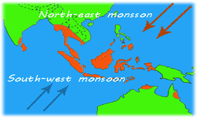
Sumatra has a wet tropical climate, with a rainy season that lasts from October to April, when rainfall typically reaches 200-300 mm per month and a dry season from May to September, when rainfall is usually below 200 mm per month (though the area is never truly dry. This is driven by the Southeast Asian Monsoon Seasons, with the Northeast Monsoon driven by winds from the South China Sea feuling the wetter rainy season and the Southwest Monsoon driven by winds from the southern Indian Ocean the drier dry season. Such a double Monsoon Season is common close to the equator, where the Sun is highest overhead around the equinoxes and lowest on the horizons around the solstices, making the solstices the coolest part of the year and the equinoxes the hottest.
The winds that drive the Northeast and Southwest Monsoons in Southeast Asia. Mynewshub.
Monsoons are tropical sea breezes triggered by heating of the land during the warmer part of the year (summer). Both the land and sea are warmed by the Sun, but the land has a lower ability to absorb heat, radiating it back so that the air above landmasses becomes significantly warmer than that over the sea, causing the air above the land to rise and drawing in water from over the sea; since this has also been warmed it carries a high evaporated water content, and brings with it heavy rainfall. In the tropical dry season the situation is reversed, as the air over the land cools more rapidly with the seasons, leading to warmer air over the sea, and thus breezes moving from the shore to the sea (where air is rising more rapidly) and a drying of the climate.
Diagrammatic representation of wind and rainfall patterns in a tropical monsoon climate. Geosciences/University of Arizona.
This year the rains were over a month late, not starting until January, and then exceptionally heavy, a pattern thought to be linked to the el Niño weather-system presently over the South Pacific; el Niño weather-systems typically being linked to more extreme weather patterns in Southeast Asia.
The El Niño is the warm phase of a long-term climatic oscillation affecting the southern Pacific, which can influence the climate around the world. The onset of El Niño conditions is marked by a sharp rise in temperature and pressure over the southern Indian Ocean, which then moves eastward over the southern Pacific. This pulls rainfall with it, leading to higher rainfall over the Pacific and lower rainfall over South Asia. This reduced rainfall during the already hot and dry summer leads to soaring temperatures in southern Asia, followed by a rise in rainfall that often causes flooding in the Americas and sometimes Africa. Worryingly climatic predictions for the next century suggest that global warming could lead to more frequent and severe El Niño conditions, extreme weather conditions a common occurrence.
Movements of air masses and changes in precipitation in an El Niño weather system. Fiona Martin/NOAA.
The development of an el Niño weather-system this year is considered particularly alarming by climate scientists, as the world has had several consecutive years in which average global sea-surface temperatures have equalled or slightly surpassed the hottest previous average temperatures recorded, despite the climate being in a la Niña phase. As sea surface temperatures are typically significantly warmer during an el Niño phase than a la Niña phase, the development of such a phase could push temperatures into areas not previously encountered on Earth since Modern Humans first appeared, potentially triggering or accelerating other climatic problems, such as glacial melting, droughts in tropical forests, and changes in ocean circulation, which might in turn take us further into unfamiliar climatic territory.
See also...


