Showing posts with label Derbyshire. Show all posts

Saturday, 17 October 2020

England's only Vulture returns to France.

A Bearded Vulture, Gypaetus barbatus, which has spent the summer in England's Peak District has returned to France. The Bird, which has a 2.5 m wingspan, was originally thought to have escaped from captivity, but DNA on two feathers recovered by a Yorkshire birdwatcher showed it to be a female Vulture which had hatched in the French Alps the previous year, part of a breeding program seeking to help re-establish the re-establish a permanent population there. The Vulture has spent four months in England, being sited in Derbyshire, Yorkshire, Lancashire, Lincolnshire, Cambridgeshire and Norfolk, but was seen flying out to sea over the coast of East Sussex on Thursday 15 July 2020. This is fairly typical behaviour for young Bearded Vultures, who often range over wide areas before returning to the area where they were raised, and is unlikely to result in a permanent population becoming established in the UK, although this is the second such Bird to have visited the UK in a relatively short period of time, with a previous visit having occurred in 2016, the first time the species had been recorded in Britain.

 
A Bearded Vulture, Gypaetus barbatus, over Derbyshire in July 2020.

Bearded Vultures are currently classified as Near Threatened under the terms of the International Union for the Conservation of Nature’s Red List of Threatened Species, having suffered sharp population declines in many areas of Asia and Africa since the start of the twenty-first century. In Europe the species was almost wiped out by the beginning of the twentieth century, due to a perception that it was a major predator of spring lambs, but in recent years has expanded its range due to successful conservation and reintroduction programs. The species is also reported to be doing well in the Himalayas and the highlands of Ethiopia, and is the subject of an active conservation plan in South Africa, but across the rest of its range, which includes all of Africa, South Asia and the Mediterranean Basin, populations of Bearded Vultures have been severely impacted by habitat loss due to expanding Human infrastructure, reduced food availability due to the disappearance of other species, deliberate poisoning intended to protect livestock from large carnivores, and, in places, active trophy hunting.

See also...


Follow Sciency Thoughts on Facebook.

Follow Sciency Thoughts on Twitter


Sunday, 3 January 2016

Magntude 1.1 Earthquake in Derbyshire, England.

The British Geological Survey recorded a Magnitude 1.1 Earthquake at a depth of about 16 km about 8 km to the southwest of the town of Chesterfield in north Derbyshire, England slightly before 9.00 pm GMT on Monday 28 December 2015. There are no reports of any injuries associated with this event, though it may have been felt locally.


The approximate location of the 28 December 2015 Chesterfield Earthquake. Google Maps.

Earthquakes become more common as you travel north and west in Great Britain, with the west coast of Scotland being the most quake-prone part of the island and the northwest of Wales being more prone  to quakes than the rest of Wales or most of England. However, while quakes in southern England are less frequent, they are often larger than events in the north, as tectonic presures tend to build up for longer periods of time between events, so that when they occur more pressure is released.

The precise cause of Earthquakes in the UK can be hard to determine; the country is not close to any obvious single cause of such activity such as a plate margin, but is subject to tectonic pressures from several different sources, with most quakes probably being the result of the interplay between these forces.

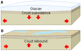
Britain is being pushed to the east by the expansion of the Atlantic Ocean and to the north by the impact of Africa into Europe from the south. It is also affected by lesser areas of tectonic spreading beneath the North Sea, Rhine Valley and Bay of Biscay. Finally the country is subject to glacial rebound; until about 10 000 years ago much of the north of the country was covered by a thick layer of glacial ice (this is believed to have been thickest on the west coast of Scotland), pushing the rocks of the British lithosphere down into the underlying mantle. This ice is now gone, and the rocks are springing (slowly) back into their original position, causing the occasional Earthquake in the process.


(Top) Simplified diagram showing principle of glacial rebound. Wikipedia. (Bottom) Map showing the rate of glacial rebound in various parts of the UK. Note that some parts of England and Wales show negative values, these areas are being pushed down slightly by uplift in Scotland, as the entire landmass is quite rigid and acts a bit like a see-saw. Climate North East.

Witness accounts of Earthquakes can help geologists to understand these events, and the structures that cause them. If you felt this quake, or were in the area but did not (which is also useful information) then you can report it to the British Geological Survey here.
 
See also...
 
http://sciencythoughts.blogspot.co.uk/2015/08/magnitude-18-earthquake-in-derbyshire.htmlMagnitude 1.8 Earthquake in Derbyshire, England.                                                The British Geological Survey recorded a Magnitude 1.8 Earthquake at a depth of 1 km about 1 km to the east of the town of Chapel-en-le-Frith in the Peak District in...
http://sciencythoughts.blogspot.co.uk/2015/07/magnitude-11-earthquake-in-south.htmlMagnitude 1.1 Earthquake in south Derbyshire, England.                             The British Geological Survey recorded a Magnitude 1.1 Earthquake at a depth of 7 km between the villages of Sutton on the Hill and Marston on Dove in...
A seven-year-old girl has escaped with cuts and bruises after falling into an 8 m sinkhole near her home in Shuttlewood, Derbyshire. Daisy-Mae Jones was playing with friends in a field near her home when she...
Follow Sciency Thoughts on Facebook.
 

Saturday, 29 August 2015

Magnitude 1.8 Earthquake in Derbyshire, England.

The British Geological Survey recorded a Magnitude 1.8 Earthquake at a depth of 1 km about 1 km to the east of the town of Chapel-en-le-Frith in the Peak District in Derbyshire, England slightly before 1.30 pm British Summertime (slightly before 12.30 pm GMT) on Wednesday 26 August 2015. There are no reports of any injuries associated with this event, though it may have been felt locally.

The approximate location of the 26 August 2015 Peak District Earthquake. Google Maps.

Earthquakes become more common as you travel north and west in Great Britain, with the west coast of Scotland being the most quake-prone part of the island and the northwest of Wales being more prone  to quakes than the rest of Wales or most of England. However, while quakes in southern England are less frequent, they are often larger than events in the north, as tectonic presures tend to build up for longer periods of time between events, so that when they occur more pressure is released.

The precise cause of Earthquakes in the UK can be hard to determine; the country is not close to any obvious single cause of such activity such as a plate margin, but is subject to tectonic pressures from several different sources, with most quakes probably being the result of the interplay between these forces.

Britain is being pushed to the east by the expansion of the Atlantic Ocean and to the north by the impact of Africa into Europe from the south. It is also affected by lesser areas of tectonic spreading beneath the North Sea, Rhine Valley and Bay of Biscay. Finally the country is subject to glacial rebound; until about 10 000 years ago much of the north of the country was covered by a thick layer of glacial ice (this is believed to have been thickest on the west coast of Scotland), pushing the rocks of the British lithosphere down into the underlying mantle. This ice is now gone, and the rocks are springing (slowly) back into their original position, causing the occasional Earthquake in the process.

(Top) Simplified diagram showing principle of glacial rebound. Wikipedia. (Bottom) Map showing the rate of glacial rebound in various parts of the UK. Note that some parts of England and Wales show negative values, these areas are being pushed down slightly by uplift in Scotland, as the entire landmass is quite rigid and acts a bit like a see-saw. Climate North East.

Witness accounts of Earthquakes can help geologists to understand these events, and the structures that cause them. If you felt this quake, or were in the area but did not (which is also useful information) then you can report it to the British Geological Survey here.

See also...

The British Geological Survey recorded a Magnitude 1.1 Earthquake at a depth of 7 km between the villages of Sutton on the Hill and Marston on Dove in south...


A seven-year-old girl has escaped with cuts and bruises after falling into an 8 m sinkhole near her home in Shuttlewood, Derbyshire. Daisy-Mae Jones was playing with friends in a field near her home when she fell into the whole, which was about a meter across...

A sinkhole 50 m across and 40 m deep opened up near the village of Foolow in the Peak District, Derbyshire, England, early in the morning of Monday 30 December 2013. No buildings were damaged nor any...

Follow Sciency Thoughts on Facebook.

Friday, 3 July 2015

Magnitude 1.1 Earthquake in south Derbyshire, England.

The British Geological Survey recorded a Magnitude 1.1 Earthquake at a depth of 7 km between the villages of Sutton on the Hill and Marston on Dove in south Derbyshire, England slightly before 2.35 pm British Summertime (slightly before 1.35 pm GMT) on Friday 27 June 2015. There are no reports of any injuries associated with this event, though it may have been felt locally.

The approximate location of the 27 June 2015 Derbyshire Earthquake. Google Maps.

Earthquakes become more common as you travel north and west in Great Britain, with the west coast of Scotland being the most quake-prone part of the island and the northwest of Wales being more prone  to quakes than the rest of Wales or most of England. However, while quakes in southern England are less frequent, they are often larger than events in the north, as tectonic presures tend to build up for longer periods of time between events, so that when they occur more pressure is released.

The precise cause of Earthquakes in the UK can be hard to determine; the country is not close to any obvious single cause of such activity such as a plate margin, but is subject to tectonic pressures from several different sources, with most quakes probably being the result of the interplay between these forces.

Britain is being pushed to the east by the expansion of the Atlantic Ocean and to the north by the impact of Africa into Europe from the south. It is also affected by lesser areas of tectonic spreading beneath the North Sea, Rhine Valley and Bay of Biscay. Finally the country is subject to glacial rebound; until about 10 000 years ago much of the north of the country was covered by a thick layer of glacial ice (this is believed to have been thickest on the west coast of Scotland), pushing the rocks of the British lithosphere down into the underlying mantle. This ice is now gone, and the rocks are springing (slowly) back into their original position, causing the occasional Earthquake in the process.

(Top) Simplified diagram showing principle of glacial rebound. Wikipedia. (Bottom) Map showing the rate of glacial rebound in various parts of the UK. Note that some parts of England and Wales show negative values, these areas are being pushed down slightly by uplift in Scotland, as the entire landmass is quite rigid and acts a bit like a see-saw. Climate North East.

Witness accounts of Earthquakes can help geologists to understand these events, and the structures that cause them. If you felt this quake, or were in the area but did not (which is also useful information) then you can report it to the British Geological Survey here.

See also...

The British Geological Survey recorded a Magnitude 1.4 Earthquake at a depth of 2 km about 10 km to the east of Loughborough in Leicestershire, England...


The British Geological Survey recorded a Magnitude 2.8 Earthquake at a depth of 7 km between Nottingham and Mansfield in southwest Nottinghamhire, England, slightly after 7.15 pm GMT on Tuesday 28 October 2014. An event of this size is highly unlikely to have caused any damage or injuries, but people have reported feeling the event across southwest Nottinghamshire.


The British Geological Survey recorded a Magnitude 1.3 Earthquake at a depth of 1 km in northern Nottinghamshire, England, slightly after 9.30 pm...


Follow Sciency Thoughts on Facebook.

Wednesday, 2 July 2014

Seven-year-old girl swallowed by 8 m sinkhole in Derbyshire, England.

A seven-year-old girl has escaped with cuts and bruises after falling into an 8 m sinkhole near her home in Shuttlewood, Derbyshire. Daisy-Mae Jones was playing with friends in a field near her home when she fell into the whole, which was about a meter across and covered by long grass. She was rescued shortly after by a neighbour with a ladder.

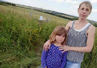
Daisy-Mae Jones with her mother,  Janine Jones, close to the Shuttlewood sinkhole. Chad.

Sinkholes are generally caused by water eroding soft limestone or unconsolidated deposits from beneath, causing a hole that works its way upwards and eventually opening spectacularly at the surface. Where there are unconsolidated deposits at the surface they can infill from the sides, apparently swallowing objects at the surface, including people, without trace.

The cause of this particular sinkhole has yet to be determined, however the area has a history of mining, and it is possible that the incident was caused by sediment subsiding into a disused mineshaft. The sinkhole is under investigation by The Coal Authority.

The approximate location of the Shuttlewood sinkhole. Google Maps.

See also...


Three homes were evacuated after a 7.5 m wide sinkhole oppened up in Rippon, North Yorkshire, on...


A sinkhole 50 m across and 40 m deep opened up near the village of Foolow in the Peak District, Derbyshire, England, early in the morning of Monday 30 December 2013. No buildings were damaged nor any injuries reported, but a power line was broken and had to be re-routed following the event.


The British Geological Survey recorded a Magnitude 1.2 Earthquake in Derbyshire, England, close to the Peak...

Follow Sciency Thoughts on Facebook.

Monday, 30 December 2013

Fifty meter sinkhole opens up in Peak District, Derbyshire.

A sinkhole 50 m across and 40 m deep opened up near the village of Foolow in the Peak District, Derbyshire, England, early in the morning of Monday 30 December 2013. No buildings were damaged nor any injuries reported, but a power line was broken and had to be re-routed following the event.

The Foolow Sinkhole on 30 December 2013. F Stop Press.

Sinkholes are generally caused by water eroding soft limestone or unconsolidated deposits from beneath, causing a hole that works its way upwards and eventually opening spectacularly at the surface. Where there are unconsolidated deposits at the surface they can infill from the sides, apparently swallowing objects at the surface, including people, without trace.

The precise cause of this sinkhole has yet to be determined, and it under investigation by the British Geological Survey. Much of the Peak District lies on porous limestone which can be eroded away by water percolating through the rock, forming numerous cave systems that are a popular tourist attraction in the area. When such caves reach the top of the limestone layers unconsolidated sediments above collapse into the resulting voids abruptly, creating sinkholes at the surface. The area has suffered high levels of rain over the past week (as has much of the UK), so erosion in such a cave system would not be a surprise. 

The area where the sinkhole opened is also a site of historic lead mining, and it is possible that an abandoned mine could have caved in causing the hole at the surface. Such mine collapses are also more likely in wet conditions, which can weaken mine supports and exposed strata.

The approximate location of the Foolow sinkhole. Google Maps.


Follow Sciency Thoughts on Facebook.

Wednesday, 7 August 2013

Magnitude 1.2 Earthquake in the Peak District, Derbyshire.

The British Geological Survey recorded a Magnitude 1.2 Earthquake in Derbyshire, England, close to the Peak District villages of Peak Forest and Old Dam slightly after 2.15 pm British Summertime (slightly after 1.15 pm GMT) on Tuesday 6 August 2012. This is a small quake, and unlikely to have caused any damage or injuries, but may have been felt locally. 

The approximate location of the 6 August 2013 Derbyshire Earthquake. Google Maps.

Earthquakes become more common as you travel north and west in Great Britain, with the west coast of Scotland being the most quake-prone part of the island and the northwest of Wales being more prone  to quakes than the rest of Wales or most of England.

The precise cause of Earthquakes in the UK can be hard to determine; the country is not close to any obvious single cause of such activity such as a plate margin, but is subject to tectonic pressures from several different sources, with most quakes probably being the result of the interplay between these forces.

Britain is being pushed to the east by the expansion of the Atlantic Ocean and to the north by the impact of Africa into Europe from the south. It is also affected by lesser areas of tectonic spreading beneath the North Sea, Rhine Valley and Bay of Biscay. Finally the country is subject to glacial rebound; until about 10 000 years ago much of the north of the country was covered by a thick layer of glacial ice (this is believed to have been thickest on the west coast of Scotland), pushing the rocks of the British lithosphere down into the underlying mantle. This ice is now gone, and the rocks are springing (slowly) back into their original position, causing the occasional Earthquake in the process. 

Witness accounts of Earthquakes can help geologists to understand these events, and the structures that cause them. If you felt this quake, or were in the area but did not (which is also useful information) then you can report it to the British Geological Survey here.


Follow Sciency Thoughts on Facebook.