Showing posts with label Kerguelen Microcontinent. Show all posts

Wednesday, 3 February 2016

Scientists observe eruption on Heard Island.

A group of scientists from the Australian Commonwealth Scientific and Industrial Research Organisation (CSIRO) have observed am eruption on Heard Island, a remote Australian territory in the southern Indian Ocean, while on a voyage to the remote Kerguelen Plateau in the Research Vessel Investigator. Eruptions on the island are thought to be quite common, but due to the remoteness of the location (nobody has set foot on the island for around 30 years) they tend not to be recorded unless they are large enough to be seen in satellite images.

A small volcanic plume emerging from the summit of Mawson Peak on Heard Island. Peter Harms/CSIRO.

Heard Island is part of the Kerguelen Plateau, a sunken microcontinent roughly 3000 km to the southwest of Australia, which is believed to have been part of the ancient supercontinent of Gondwana prior to its breakup. Most of the microcontinent is now an average of 600 m below the sea surface but the volcanic Kerguelen Islands plus the Heard and MacDonald Islands still rise above sealevel. Volcanism on the plateau began during the breakup of Gondwana, with the formation of the Kerguelen Hotspot between the landmasses that went on to become India and Antarctica, and is still going on to a minor extent on Heard and MacDonald Islands. The area is thought to have been covered with Conifer forests during the Cretaceous, and the islands still host unique floral communities.

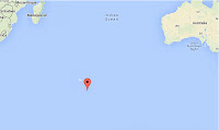
 The approximate location of Heard Island. Google Maps.

The scientists were in the area primarily to study underwater plumes associated with submarine volcanoes on the Kerguelen Plateau, of which about fifty have been observed to date, and were not confident of seeing the islands of the region at all, due to constant heavy cloud cover in the region, but in the event have witnessed plumes over both Heard and MacDonald islands, as well as lava flowing over the surface of a glacier on Heard Island.

Video footage of eruptive activity on Heard Island shot by scientists on the RV Investigator. Institute for Marine and Antarctic Studies.

See also...
http://sciencythoughts.blogspot.co.uk/2015/11/eruption-on-heard-island.htmlEruption on Heard Island.                                A United States Air Force satellite detected an ash plume above Heard Island, an uninhabited volcanic island roughly in the Southern Ocean, midway between Madagascar, Antarctica and Australia on Friday 30...
http://sciencythoughts.blogspot.co.uk/2012/11/volcanic-activity-on-heard-island.htmlVolcanic activity on Heard Island.              Heard Island is a remote volcanic island on the Kerguelen Plateau in the southern Indian Ocean. It is made up of two volcanoes, the larger Big Ben to the southeast and the smaller Mount Dixon...
Follow Sciency Thoughts on Facebook.

Thursday, 5 November 2015

Eruption on Heard Island.

A United States Air Force satellite detected an ash plume above Heard Island, an uninhabited volcanic island roughly in the Southern Ocean, midway between Madagascar, Antarctica and Australia on Friday 30 October 2015. This is the first activity detected on the island since 2013, though the island is so remote that activity in the intervening time cannot be ruled out.

The approximate location of Heard Island. Google Maps.

Heard Island is part of the Kerguelen Plateau, a sunken microcontinent roughly 3000 km to the southwest of Australia, which is believed to have been part of the ancient supercontinent of Gondwana prior to its breakup. Most of the microcontinent is now an average of 600 m below the sea surface but the volcanic Kerguelen Islands plus the Heard and MacDonald Islands still rise above sealevel. Volcanism on the plateau began during the breakup of Gondwana, with the formation of the Kerguelen Hotspot between the landmasses that went on to become India and Antarctica, and is still going on to a minor extent on Heard and MacDonald Islands. The area is thought to have been covered with Conifer forests during the Cretaceous, and the islands still host unique floral communities.

Plate reconstructions of the southern Indian Ocean region. Red stars = possible reconstructed positions of the Kerguelen Hotspot; those labeled “K” assume that the Kerguelen archipelago is the current location of the Kerguelen hotspot, and those labeled “H” assume that Heard Island is the hotspot’s current location. Black shading = magmatism associated with the Kerguelen Hotspot, diamonds = lamprophyres (labeled with “L” in 110 Ma panel) as they have appeared through geologic time. Dashed line = a possible northern boundary for Greater India. IND = India, ANT = Antarctica, AUS = Australia. (A), (B) Seafloor spreading initiated at ~133 Ma between Western Australia and Greater India and at ~125 Ma between Australia and Antarctica. This model assumes breakup between India and Antarctica at ~133 Ma, although the timing of this event is not well known. The Bunbury Basalt (BB) of Southwest Australia erupted close to these breakup events in both time and space. Continental portions of Elan Bank (EB) and the Southern Kerguelen Plateau (unknown dimensions) remained attached to Greater India at these times. The Naturaliste Plateau (NP) also contains continental crust. (C), (D) Seafloor spreading continued between India, Antarctica, and Australia. The initial massive pulse of Kerguelen magmatism created the Southern Kerguelen Plateau (SKP), the Rajmahal Traps (RAJ), and Indian/Antarctic lamprophyres (L) from ~120 to ~110 Ma (Fig. F3, p. 38) and may be linked to breakup and separation between Elan Bank and Greater India. The Central Kerguelen Plateau (CKP) formed between ~105 and ~100 Ma and Broken Ridge (BR) between ~100 and ~95 Ma (Fig. F3, p. 38). Igneous basement of the Wallaby Plateau (WP) is not well characterized geochemically and has not been dated, but its age is inferred to lie between ~120 and ~100 Ma. (E), (F) The hotspot generated the Ninetyeast Ridge (NER) and Skiff Bank (SB) as India continued its northward drift relative to Antarctica. (G), (H) At ~40 Ma, seafloor spreading commenced between the Central Kerguelen Plateau and Broken Ridge. The hotspot generated the Northern Kerguelen Plateau (NKP), and, since 40 Ma, as Broken Ridge and the Kerguelen Plateau have continued to separate, has produced the Kerguelen Archipelago, Heard and McDonald Islands, and the chain of volcanoes between Kerguelen and Heard. Frey et al. (2003).


See also...

Heard Island is a remote volcanic island on the Kerguelen Plateau in the southern Indian Ocean. It is made up of two volcanoes, the larger Big Ben to the southeast and the smaller Mount Dixon to the...


Mount Siple is one of the world's most remote volcanoes, located on Siple Island, off the coast of Marie Byrd Land, Antarctica. It is a shield volcano (volcano with a fairly flat profile made up mostly...


On Sunday 15 January 2012 at approximately 9.40 am local time (1.40 pm GMT) Elephant Island in the South Shetland Islands was shaken by an Earthquake measuring 6.6 on the Richter Scale at a depth of approximately 10 km, according to the United States Geological Survey. This was followed by a...


Follow Sciency Thoughts on Facebook.

Thursday, 1 November 2012

Volcanic activity on Heard Island.

Heard Island is a remote volcanic island on the Kerguelen Plateau in the southern Indian Ocean. It is made up of two volcanoes, the larger Big Ben to the southeast and the smaller Mount Dixon to the northeast. The crater of Big Ben forms a 5-6 km wide caldera, breached to the southwest, with a second smaller volcano, Mawson Peak, within. The summit of Mawson Peak forms the highest point on the island, at 2475 m above sea-level (it is also technically Australia's highest mountain). This is considered to be an active volcano, though little is known about its activity due to its remote location and covering of glaciers.

Composite Satellite image showing the position of Heard Island and the Kerguelen Plateau. Google Maps.

Heard Island seen from the sea. Heard Island Solo.

On 21 and 24 September and 10 and 19 October satellites passing over Heard Island detected thermal anomalies, suggesting that a an eruption could be occurring on the island. A visual image captured by NASA's Earth Observing-1 satellite on 13 October 2012 may support this, though it is not completely clear. The summit appears to show reduced snow cover and there is a dark area within the crater which may indicate fresh lava. The island is covered by cloud for much of the time, making these observations rare.

(Top) Earth Observing-1's 13 October image of Heard Island. (Bottom) An image taken in February 2009 from the International Space Station for comparison. Not the more defined shape of Mawson's Peak in the upper image, implying melting of snow cover. NASA/Earth Observatory.

The Kerguelen Plateau is an underwater volcanic large igneous province formed by volcanic activity starting about 110 million years ago. It has sedimentary rocks which suggest the bulk of the plateau may have been above the sea for much of this time, sinking about 20 million years ago, causing some to consider it a submerged continent. The volcanic activity is thought to come from a hotspot created during the breakup of the Gondwanan continent in the mid-Cretaceous. The landmass may once have been continuous with Australia and India; it is thought that in the Cretaceous it would have formed a microcontinent largely covered by vast coniferous woodlands. Most of the plateau is now about 600 m below sea-level.

Map showing the positions of the parts of the former Gondwanan continent in the Late Cretaceous, 85 million years ago. Kerguelen is highlighted in orange. Ali & Aitchison (2009).


Follow Sciency Thoughts on Facebook.