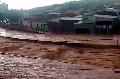
A series of landslides and flash floods have killed at least fifty four people in Brazil since Thursday 23 January 2020. As well as the known deaths a further eighteen people are currently missing, and over 30 000 people have been forced to flee their homes in the states of Minas Gerias, Espirito Santo, and Rio Grande do Sul. The rains began on Thursday 23 January, when over 100 mm of rain fell in twenty four hours in parts of Minas Gerias, the most rain recorded in a single day for over a century, and are predicted to continue for at least the rest of this week. Landslides are a common problem after severe weather events, as excess
pore water pressure can overcome cohesion in soil and sediments,
allowing them to flow like liquids. Approximately 90% of all landslides
are caused by heavy rainfall.
Rescue workers search the site of a landslide in the Vila Ideal neighborhood in Belo Horizonte, Minas Gerais State, Brazil, on Friday 24 January 2020. Cristiane Mattos/Reuters.
Southern Brazil has a rainy season that lasts from Ocotober to March, with peak rains from mid-November to mid-January, however, this year's rains have been exceptionally strong. Brazil has suffered a string of flood-related disasters in recent years,
most notably in 2011, when over 800 people died. The country has a
rapidly growing population, with little effective urban planning, which
has led to sprawling urban developments springing up with little thought
to natural hazards, and in particular poorer neighborhoods often
expanding up unstable hillsides, with the result that when floods occur
(which is not unusual) communities are often quickly overwhelmed. This
years exceptional rains have led to more widespread flooding, which may
also persist for longer, and there is a distinct danger that without
determined action the death toll may exceed that of 2011.
Flooding in Belo Horizonte on 24 January 2020. TV Brasil.
This extreme weather may be linked to a developing El Niño wearther system over the Pacific Ocean. The
El Niño is the warm phase of a long-term climatic oscillation affecting
the southern Pacific, which can influence the climate around the world.
The onset of El Niño conditions is marked by a sharp rise in
temperature and pressure over the southern Indian Ocean, which then
moves eastward over the southern Pacific. This pulls rainfall with it,
leading to higher rainfall over the Pacific and lower rainfall over
South Asia. This reduced rainfall during the already hot and dry summer
leads to soaring temperatures in southern Asia, followed by a rise in
rainfall that often causes flooding in the Americas and sometimes
Africa. Worryingly climatic predictions for the next century suggest
that global warming could lead to more frequent and severe El Niño
conditions, extreme weather conditions a common occurrence.
Movements of air masses and changes in precipitation in an El Niño weather system. Fiona Martin/NOAA.
See also...
Follow Sciency Thoughts on Facebook.


