The Philippine Institute of Volcanology and Seismology recorded a Magnitude 7.8 Earthquake at a depth of 33 km off the south coast of Mindanao Island, Philippines, slightly after 7.35 am on Monday 8 June 2026 local time (slightly after 11.35 pm on Sunday 7 June GMT).

Thirty five people have been confirmed dead following this event, with another 134 injured, and a large number of buildings damaged or destroyed, with about 10 000 families displaced as a result of this Earthquake. People reported feeling tremors as far away as Manilla and northern Borneo. Countries around the Pacific Rim issued tsunami warnings after the event, although the largest wave recorded was about 1.4 m. Mindanao has subsequently been hit by a number of large aftershocks.

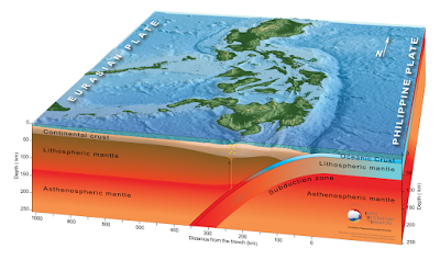
The geology of the central Philippines is Complex. The west of Mindanao Island is located on the Banda (or Sunda) Microplate, and the east on the Philippine Plate, which is being subducted beneath the Sunda (or Banda) Microplate along the central part of the island. Immediately to the east of the Island the Pacific Plate is being subducted along the Philippine Trench, and passes beneath eastern Mindanao as it sinks into the Earth. This is not a smooth process, an the plates constantly stick together then break apart again as the pressure builds up, resulting in Earthquakes.

See also...

.png)

.png)

.png)


.jpg)
.jpg)
.gif)